Archiv - Nach Datum
Archiv - Nach Aktivität
-
Andere Tour (1)
- Kayaking (1)
-
Andere Wintertour (4)
- Schneeschuhtour (4)
-
Fahrradtour (137)
- Fahrradtour Straße (9)
- Fahrradtour gemischt (51)
-
Fußtour (740)
- Bergtour (363)
- Jogging (18)
- Spaziergang (89)
- Wanderung (270)
-
Skitour (4)
- Tourenskilauf (4)
Archiv - Nach Geografie
Peakbookfreunde


Gesammelte Listen
-
Bergen ≥ 50m pf. og ≥ 100 m.o.h.
(87/89)
 97%
97% -
Most dominating tops of the Bergen peninsula
(68/75)
90%
-
Utvalgte topper og turmål i Bergen
(316/350)
90%
-
Alle topper i Bergen
(357/398)
89%
-
Opptur Bergen
(100/113)
88%
-
De syv fjell rundt Bergen
(6/7)
85%
-
Sund ≥ 50m pf.
(14/18)
77%
-
Os ≥ 50m pf.
(25/34)
73%
-
Søyler (fastmerker) i Bergen
(68/100)
68%
-
Fjell ≥ 50m pf.
(21/32)
65%

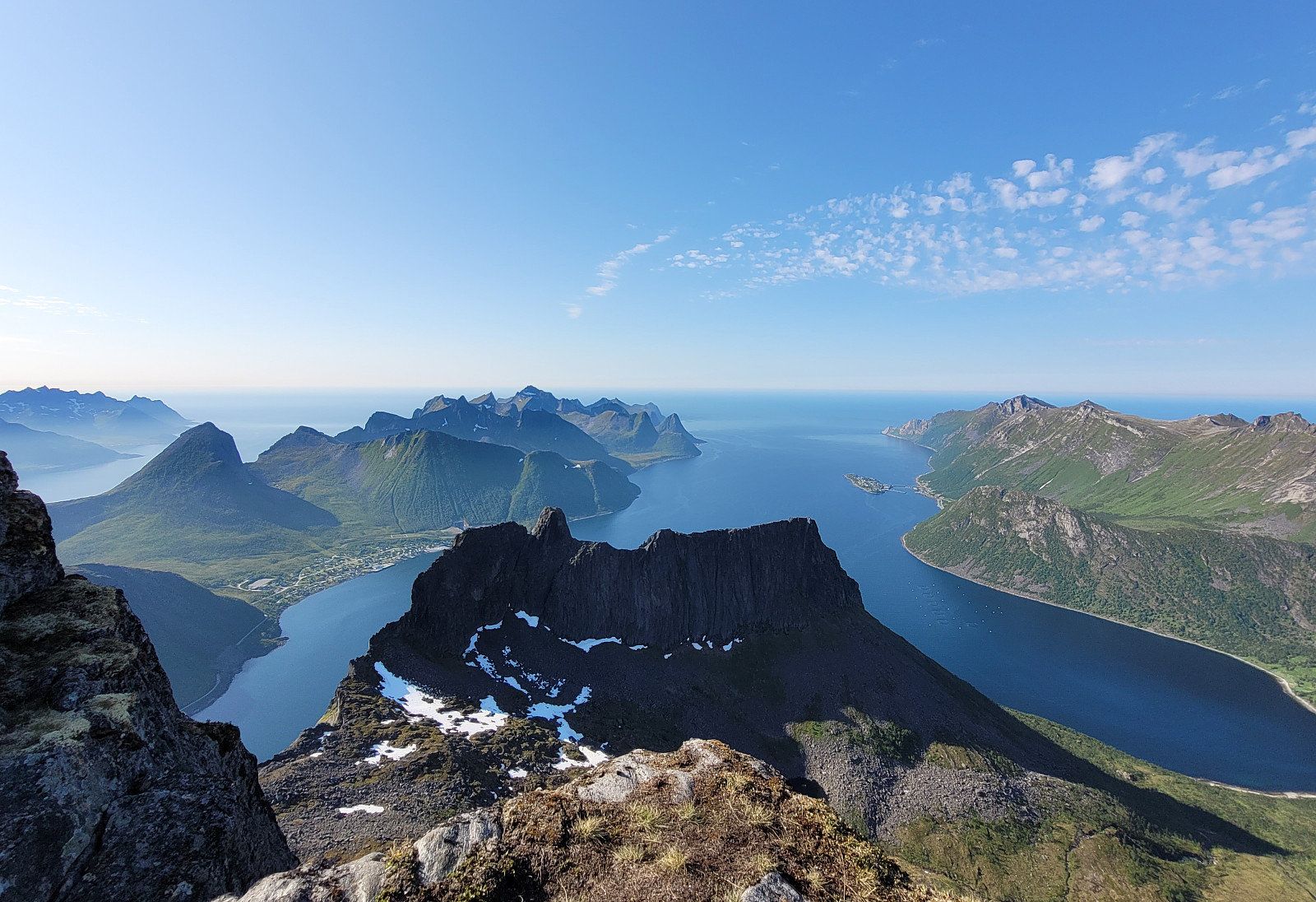
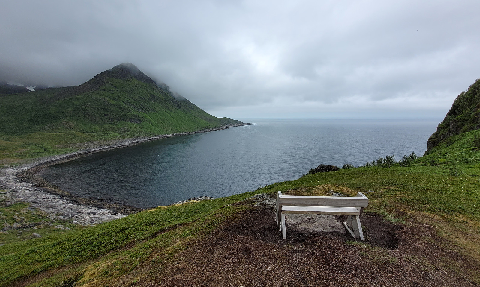
Vasstinden from Lauklineset
- Datum:
- 02.07.2023
- Tourcharakter:
- Wanderung
- Tourlänge:
- 4:00h
- Entfernung:
- 8,1km
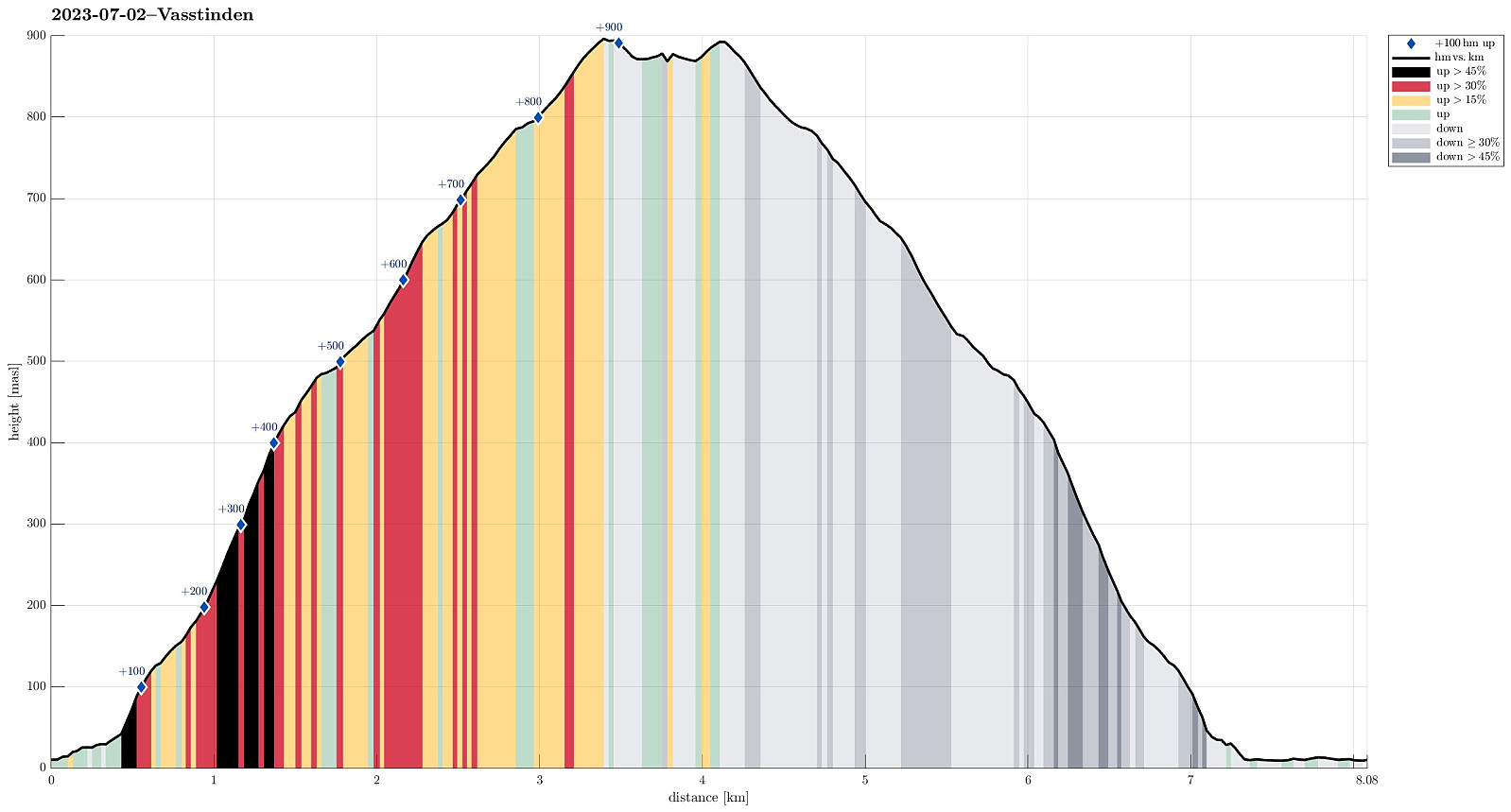 We estimated that there was enough time for another hike (before reaching our flight back from Tromsø). We drove towards Lauklineset on the north of Nordfjorden and parked a bit off from Lauklineset, where some parking place is set off for hikers (you pay a little for parking there, also). From this parking place, there's a marked trail up to Vasstinden. While still close to the road and Lauklineset, this trail is not very good (and one may prefer to walk the first meters along the road, instead). Once directly above Lauklineset, however, the trail is good, leading steeply upwards between the trees. At about 150masl, the trail levels out for a few meters before it gets steep again. At about 440masl, there's a sign that shows the hikers where the marked trail continues (towards the east, >>>
Buren (and an attempt to Rødtinden)
- Datum:
- 01.07.2023
- Tourcharakter:
- Wanderung
- Tourlänge:
- 4:30h
- Entfernung:
- 9,6km
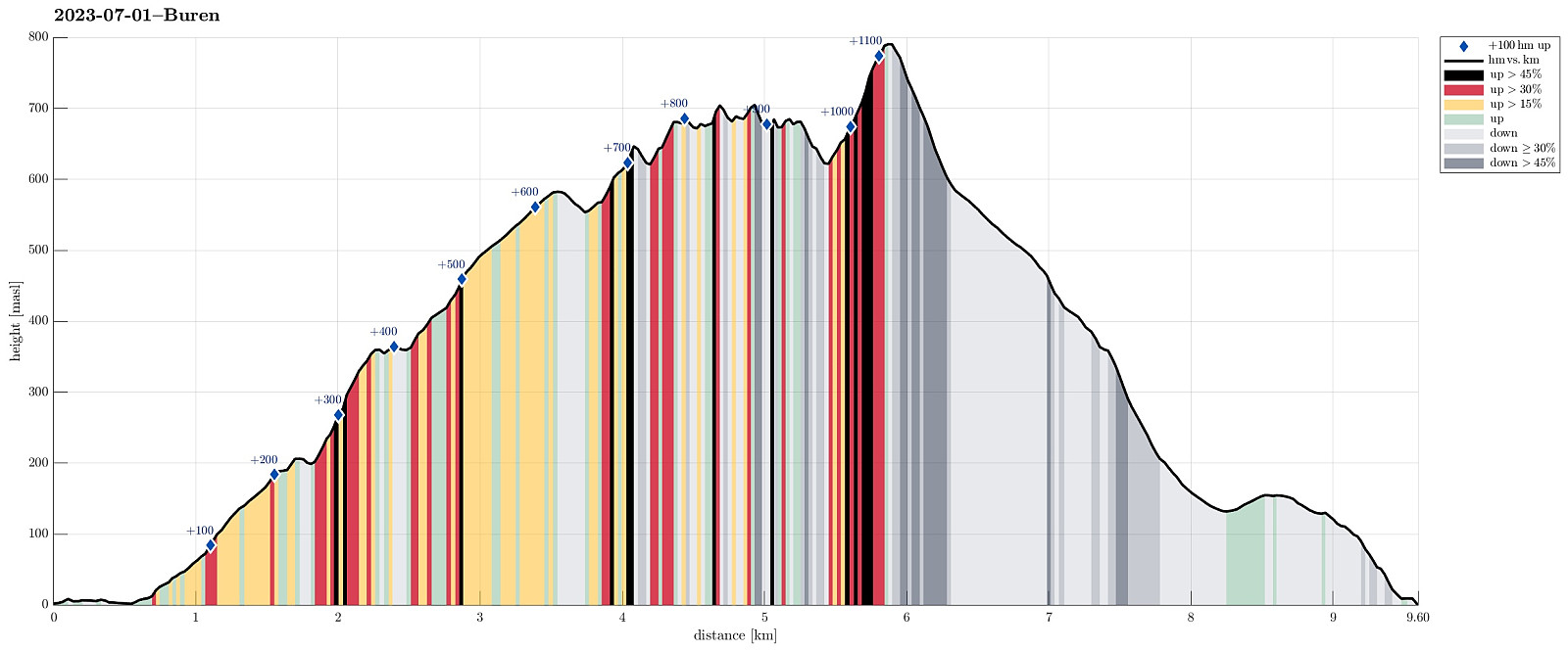 We had relocated ourselves from Senja to Kvaløya (to Ersfjordbotn -- as if there wasn't any Ersfjorden on Senja!). Also this day looked very promising and with wonderful mountains just "around the corner", the plan was to hike up to Buren (without driving). The hidden agenda for this hike was to also try an ascent to Rødtinden, if possible. Starting along Naustbuktvegen, I first walked along the coast into the direction of Gottberget. There, I found a trail that lead me up to a simple ridge which comes down from Skålhammaren (further up in the northeast of Gottberget). Also along this ridge, I could find a simple trail, leading me up to a nice viewpoint at about 200masl (also with a small cairn there). From there, however, I could not find any trail that would lead further >>>
Astritinden from Botnhamn
- Datum:
- 30.06.2023
- Tourcharakter:
- Wanderung
- Tourlänge:
- 4:00h
- Entfernung:
- 12,7km
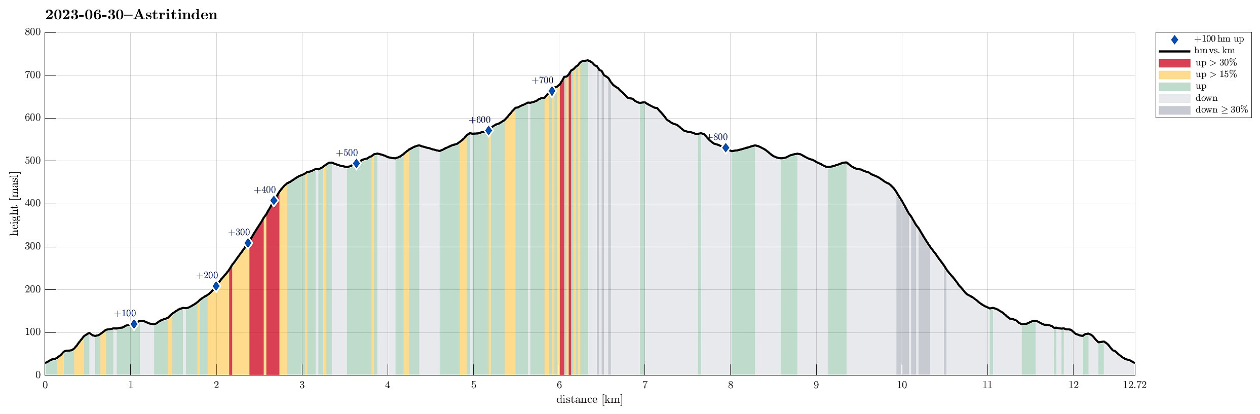 We had to catch a ferry from Botnhamn to Kvaløya and thus planned to hike Astritinden in the time given before the departure of "our" ferry. Right next to the soccer field of Botnhamn (near Mølnneset) we could park the car. The hike then starts with getting up to Sandbakkveihøgda, following one of the marked trails (eventually up right underneath the power line). Once up there, it's then "just" to follow the (long) ridge to Astritinden (steadily in northern / northwestern direction). Only a few kilometers into this hike, one puts in a significant ascent (up to Kvannaksla at about 500masl). There, the hike levels out, again, a little, before the actual ascent up to Astritinden follows a little later. While all of the hike to Astritinden is not really difficult, the >>>
Grytetippen and Keipen
- Datum:
- 29.06.2023
- Tourcharakter:
- Wanderung
- Tourlänge:
- 4:30h
- Entfernung:
- 10,2km
 Another nice day on Senja, another chance for a nice hike! :-) We drove to Mefjordeidet, basically where Arnakkveien "disappears" into the tunnel down to Ørnfjorden, and parked there at the small parking place. We then started to follow a marked trail "straight up" (in northern direction) that lead us to Daven, a first little top (with nice views, though!). From Daven, it was then across a small saddle (in the east of Daven) and up to some intermediate heights in the south of Keipen (at about 525masl). Crossing over these intermediate heights, first, and then ascending (steeply) up, we arrived at the saddle between Grtyetippen (in the west) and Keipen (in the east / northeast) at about 730 masl. From there, we first included Grytetippen, enjoying fantastic views from >>>
Sandsvika from Barbogen
- Datum:
- 28.06.2023
- Tourcharakter:
- Spaziergang
- Tourlänge:
- 5:00h
- Entfernung:
- 9,8km
 Given another day with low handing clouds, we chose to visit Sandsvika, Senja's longest sand beach! :-) While it seems possible to get to Sandsvika from Ballesvika (via Tortenberget, then passing by Teisten over Teisteskaret), also (long hike, in particular when done there and back in one go), we decided to walk over to Sandsvika from Barbogen. To get to Barbogen, just across Gryllefjorden, we contacted Kaikanten in Gryllefjord and they offered to ship us over (and later back, also) by boat from Gryllefjord. This worked just perfectly and easily got to Sandsvika from Barbogen, walking across Sandsvikskaret along the way. Sandsvika is indeed very impressive (also the history of it -- we learned, given that this information was accurate, that at one time longer ago a four-digits number of people lived >>>
Husfjellet and Litjebrusen
- Datum:
- 27.06.2023
- Tourcharakter:
- Wanderung
- Tourlänge:
- 3:00h
- Entfernung:
- 9,7km
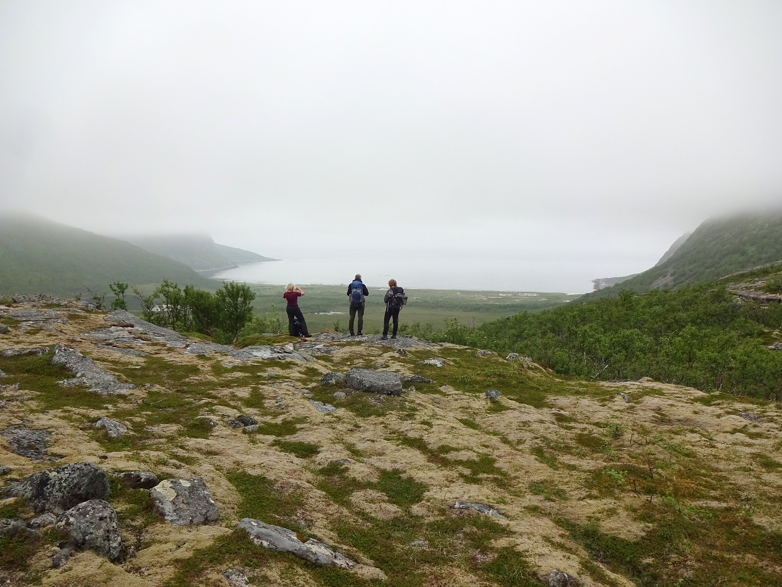
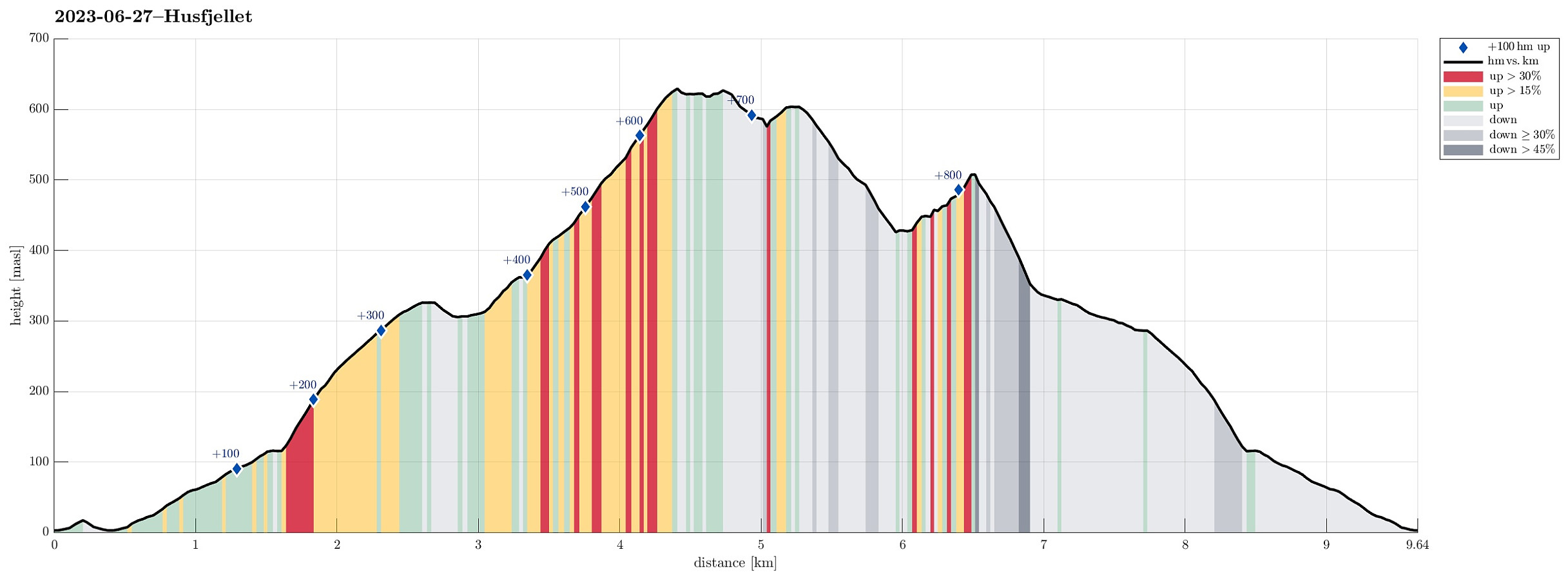 After looking at Husfjellet from Flobjørn , earlier the same day, we followed our plan to hike Husfjellet around midnight, exploiting the time of the year when the sun never sets at these latitudes. We parked near Berg church at Skaland and followed the marked trail up to Husfjellet. Up to about 115masl, this trail follows first a gravel road, before then continuing "straight up" on the western side of Sommardalen. On Sommardalhaugen, at about 325masl, then one can enjoy some nice views, already. The continuation towards the ridge that leads up to Rismåltua, which leads across some wet grounds in the uppermost parts of Sommardalen, has suffered by now from the many visitors that have hiked up here. It really looks that some protection, maybe with wooden planks, or the like, would be >>>
Flobjørn
- Datum:
- 27.06.2023
- Tourcharakter:
- Wanderung
- Tourlänge:
- 3:00h
- Entfernung:
- 5,6km
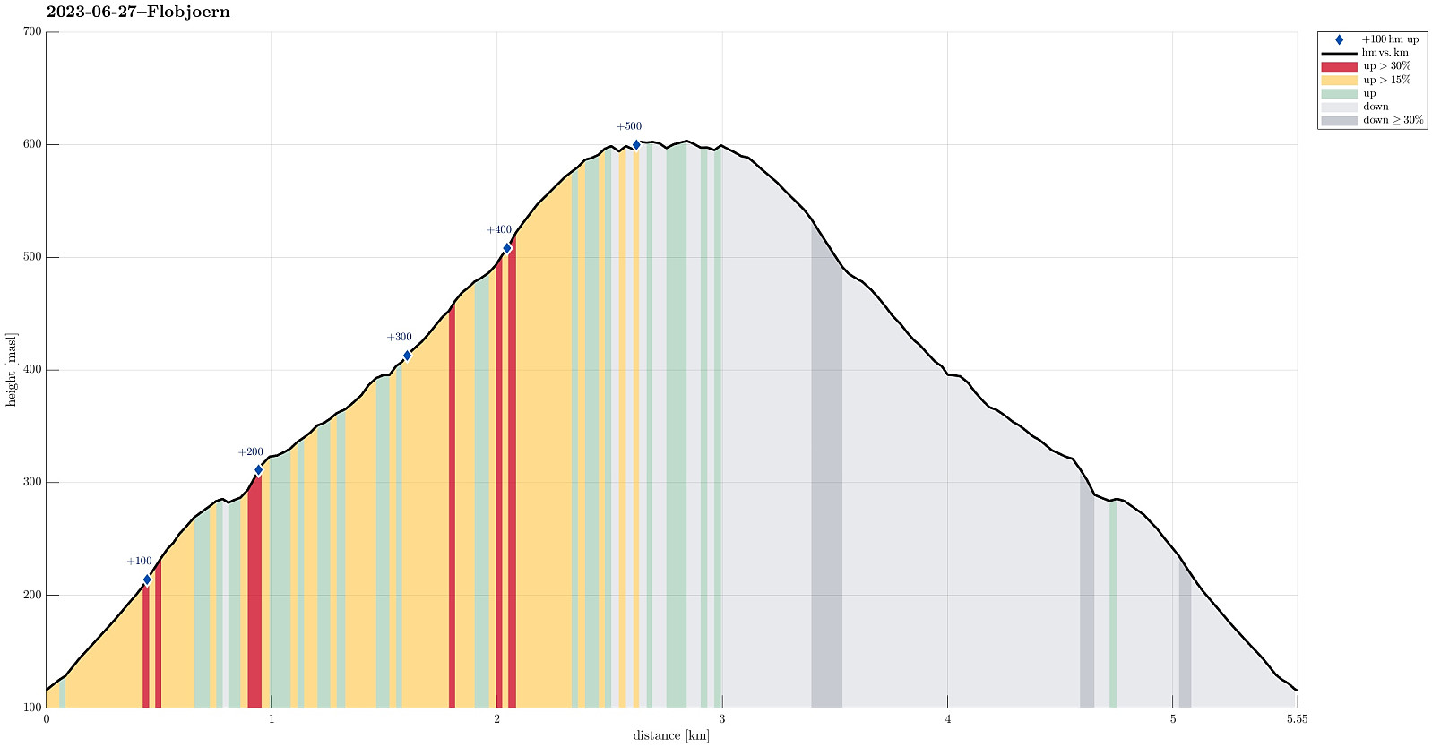 Since we also wanted to hike up Husfjellet in the evening/night, this day, we decided to take it a bit easier during noon-time. Following Bergsfjordveien (through the tunnel to Krokelvvatnet), we drove down Krokelvdalen towards Straumsbotn. Before getting all the way down, however, at about 115masl, we parked next to the road -- right next to the trailhead, also (while there isn't really a parking place, the street is widened there to ease the passing of cars; leaving as much as space as possible, we still found it OK to park there for a few hours). From there, it's then "just" following the marked trail up to Jøvikskaret, first, and then further up to Flobjørn. While this really is a very easy hike, one still gets wonderful views, especially from the top of Flobjørn! After having some >>>
Segla and Barden
- Datum:
- 26.06.2023
- Tourcharakter:
- Wanderung
- Tourlänge:
- 5:30h
- Entfernung:
- 8,3km
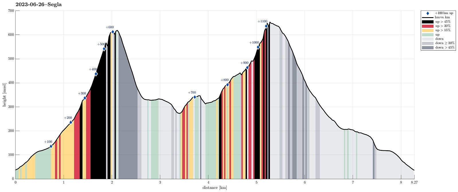 We woke up to a wonderful day and decided to do Senja's signature mountain, Segla, at once! :-) We drove through Senja's longest tunnel, Fjordgårdtunnelen, to Fjordgård, were we parked near the trailhead for Segla. We followed the marked trail, first into the direction of Storevatnet, before then turning more towards Segla. Many do this hike to Segla -- thus, the trail is wide and easy to follow. At about 330 masl, one gets to the ridge and thus looks down to Mefjorden first the first time on this hike. The west side of this ridge is really very, very steep (close to vertical, actually), so if you are afraid of heights, then it may be good to choose your steps and views with some care up there. To the top of Segla, it's then "basically" just "straight up" on the >>>
Bekkarhalsen at Skøyteneset
- Datum:
- 25.06.2023
- Tourcharakter:
- Spaziergang
- Tourlänge:
- 4:00h
- Entfernung:
- 7,3km
 With no major mountain tops to see (due to low hanging clouds), we decided to make another excursion along the shoreline -- this time to Skøyteneset from Medfjordvær. We parked near Knuten in the north of Mefjordvær and walked up to Halsen, first. Then we included Knuten, which offers some nice views (even though it's not really high). We then also stepped down to the small lighthouse in the north of Knuten, before returning to Mefjordvær along the outer route around Knuten on its eastern side (probably the connection for those, who have to work at the lighthouse; or had to, previously). After this short Knuten intermezzo, we then headed out to Skøyteneset along the marked trail in the west of Knutevika, reading first about Russehula and then about Munken. Further out, the trail leads >>>
Lykteneset at Flatneset
- Datum:
- 24.06.2023
- Tourcharakter:
- Spaziergang
- Tourlänge:
- 3:30h
- Entfernung:
- 10,4km
 The clouds were hanging low and we decided to make an excursion along the coastline to Flatneset. We left Hamnveien near the bridge over Straumen, heading (for a few meters only) towards Straumsnes. After turning right (into Morrvika), we just continued a few hundred meters further until we parked at a small parking spot near the beach. To get over to Flatneset, we had to first cross over Lavollskjosen. We followed a simple trail over Skjåneshaugen to get to the southwestern side of Kjosen. Then, we walked along it (in southeastern direction) until we found a place, where we thought that crossing over should be possible (and indeed it was). On the other side, we then changed course into northwestern direction, heading towards Lykteneset on the outermost end of Flatneset. At Lavollen, >>>
