Arkiv - dato
Arkiv - aktivitet
-
Annen tur (1)
- Kajakkpadling (1)
-
Annen vintertur (4)
- Trugetur (4)
- Fottur (740)
-
Skitur (4)
- Fjellskitur (4)
-
Sykkeltur (137)
- Blandet sykling (51)
- Gatesykling (9)
Arkiv - Etter geografi
"Peakbookvenner"


Lister jeg samler etter
-
Bergen ≥ 50m pf. og ≥ 100 m.o.h.
(87/89)
 97%
97% -
Most dominating tops of the Bergen peninsula
(68/75)
90%
-
Utvalgte topper og turmål i Bergen
(316/350)
90%
-
Alle topper i Bergen
(357/398)
89%
-
Opptur Bergen
(100/113)
88%
-
De syv fjell rundt Bergen
(6/7)
85%
-
Sund ≥ 50m pf.
(14/18)
77%
-
Os ≥ 50m pf.
(25/34)
73%
-
Søyler (fastmerker) i Bergen
(68/100)
68%
-
Fjell ≥ 50m pf.
(21/32)
65%

Gravdalsfjellet from Løvås
- Dato:
- 09.03.2024
- Turtype:
- Blandet sykling
- Turlengde:
- 3:00t
- Distanse:
- 12,5km
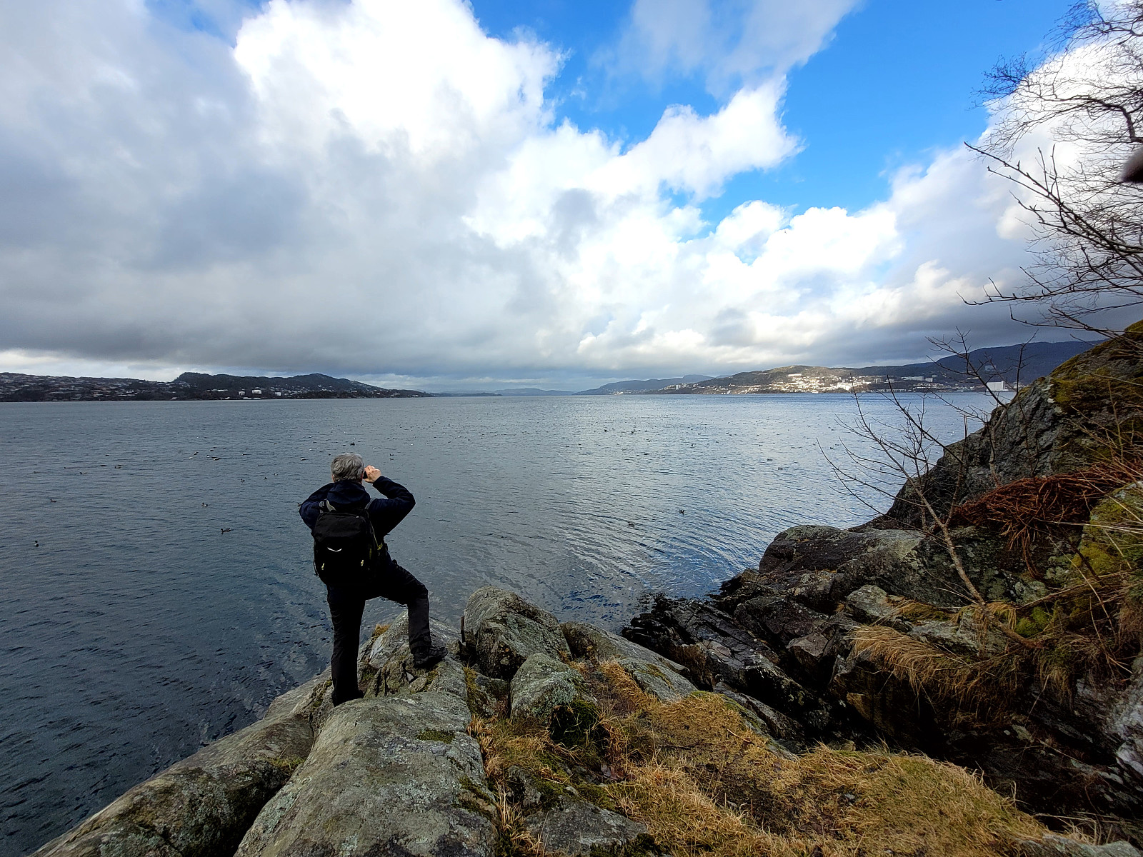
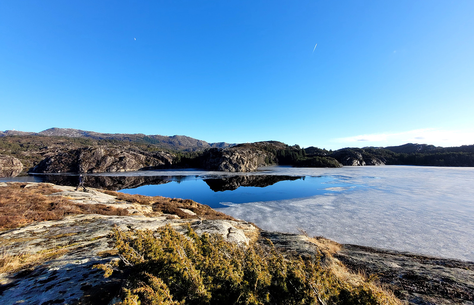
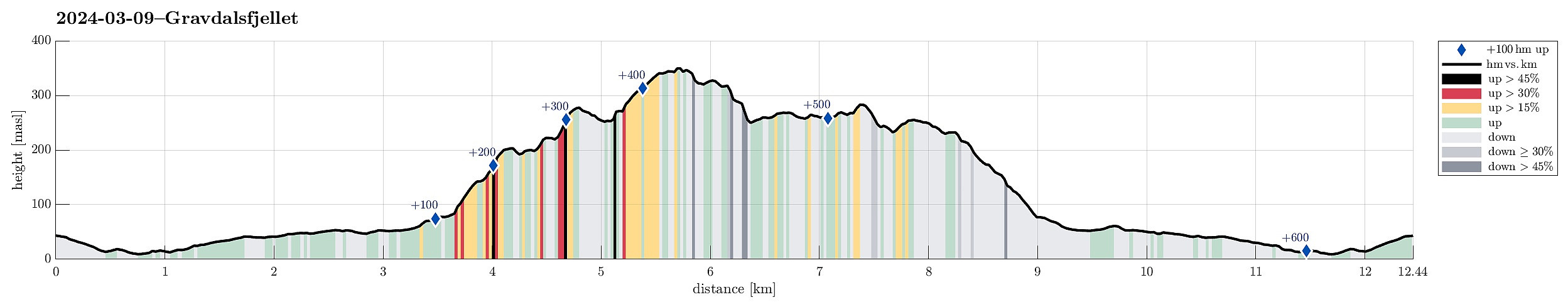 We took our eBikes and cycled to Løvås, first. From the end of Løvåsveien, we then aimed at Eikhaugen as our first intermediate hiking goal. We stayed on the eastern side of the small valley (between Eikelia in the west and Eikhaugen in the east) and ascended to Eikhaugen via the small ridges south of it. From Eikhaugen, we then continued to Tøshaugen, a little bit further north, and from there to Fyllingsnipa, yet a short bit further north. The approach to Fyllingsnipa from the south is a bit steep, but not really a problem. From Fyllingsnipa, we then continued along a proper trail to Gravdalsfjellet, passing by Viggohytten on our way up. From Gravdalsfjellet, we then continued towards Lyngbø and down to the northwestern end of Nipetjørna. After crossing over the little dam that >>>
Exploring Lyreneset on our bike-ride to Bergen
- Dato:
- 24.02.2024
- Turtype:
- Sykkeltur
- Turlengde:
- 2:00t
- Distanse:
- 17,2km
 We biked first along Bjørgeveien into the direction of Loddefjord, then around Bjørndalstjørna further northwards to Liavatnet. After cycling around Lyngbøvatnet, we made a detour to Lyreneset. There, we explored the cape by foot, also enjoying some nice views across Byfjorden. Thereafter, we continued our bike-ride towards Bergen. This bike-excursion came to an unplanned end due to a flat tire, requiring a change to public transport from there on.
Selected photos are available as Google photo album .
See also the related FB-page Hiking around Bergen, Norway .
We biked first along Bjørgeveien into the direction of Loddefjord, then around Bjørndalstjørna further northwards to Liavatnet. After cycling around Lyngbøvatnet, we made a detour to Lyreneset. There, we explored the cape by foot, also enjoying some nice views across Byfjorden. Thereafter, we continued our bike-ride towards Bergen. This bike-excursion came to an unplanned end due to a flat tire, requiring a change to public transport from there on.
Selected photos are available as Google photo album .
See also the related FB-page Hiking around Bergen, Norway .
Ørnafjellet and Austre Høghaugen
- Dato:
- 17.02.2024
- Turtype:
- Fottur
- Turlengde:
- 3:30t
- Distanse:
- 7,9km
 We expected some nice sun and decided to enjoy the day with an exploration of a part of Sotra that we had not visited before. We drove the car to Sotra and there to Fjell. South of Fjell, along Søre Fjellavegen and right next to Gardstjørna, we parked next to the road and started our hike, walking down a simple road towards Fjellspollen. Still on this road, we conveniently crossed over the waters, that spring down from Bosvatnet to Litlepollen, using the road-bridge. Studying the map at home had suggested that starting our ascent up to Ørnafjellet would be possible right from the road in the north of Litlepollen. Once there, however, we saw that the hill-side appeared a bit steeper than originally expected. Still, we could make it up to the heights in the north of Litlepollen without >>>
Kjerringafjellet from Heggland and Borgafjellet
- Dato:
- 04.02.2024
- Turtype:
- Fottur
- Turlengde:
- 4:00t
- Distanse:
- 6,9km
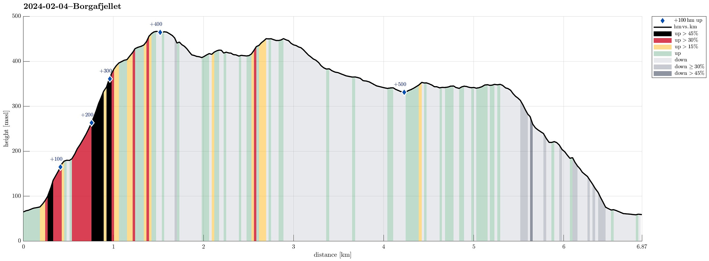 Thinking about snow at higher elevation, we made a plan for a hike that would not lead us so much up, altogether. Still, we aimed at something interesting: Hiking towards (not all the way up to, though) Møsnuken from Heggland. During an earlier hike, a sign was seen that pointed towards Møsnuken at Heggland (near Hegglandsdalsvegen in the northeast of Osøyro). The map shows an approximate trail (leading up to Hegglandstjørna), but no details are to be seen. Exploiting the fact that we came with two cars, we parked one near the planned end of the hike (below Borgafjellet) and then took the other one further along Hegglandsdalsvegen to park near Heggland. Indeed we quickly found the trail-head, again, at Heggland and started the ascent from there. The southeastern side of Møsnuken, >>>
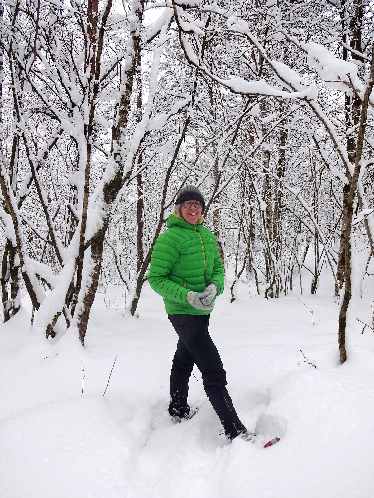
Pyttane in windy weather
- Dato:
- 03.02.2024
- Turtype:
- Fjelltur
- Turlengde:
- 1:30t
- Distanse:
- 6,7km
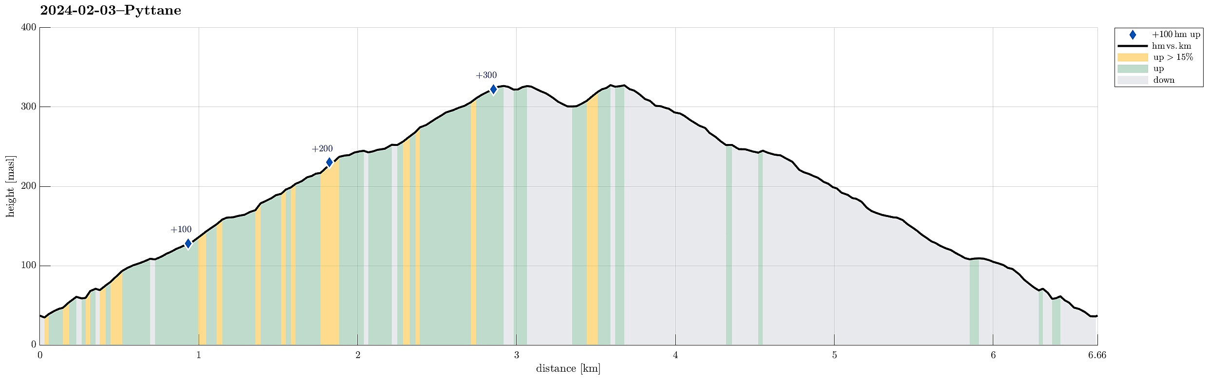 With quite a bit of weather outside, we decided to "just" go up and down Pyttane on Sotra. We took the car to Ekrhovdvegen in the very east of Sotra and parked near Nordre Stølen, where the service road up to Pyttane starts. We then walked up to the radar stations, experiencing significant weather on the top (strong winds, some precipitation). While it was nice to get out into the fresh air, we still did not feel like staying up there "in the elements" for any prolonged time, thus walking back down more or less immediately, again. All in all, this walk up to Pyttane is always nice (and easy), lending itself well to getting some fresh air without an all-too-long trip.
Selected photos are available as Google photo album .
See also the related FB-page Hiking around Bergen, Norway .
Web page WestCoastPeaks.com provides useful information about Liatårnet
and also Petter Bjørstad has a >>>
With quite a bit of weather outside, we decided to "just" go up and down Pyttane on Sotra. We took the car to Ekrhovdvegen in the very east of Sotra and parked near Nordre Stølen, where the service road up to Pyttane starts. We then walked up to the radar stations, experiencing significant weather on the top (strong winds, some precipitation). While it was nice to get out into the fresh air, we still did not feel like staying up there "in the elements" for any prolonged time, thus walking back down more or less immediately, again. All in all, this walk up to Pyttane is always nice (and easy), lending itself well to getting some fresh air without an all-too-long trip.
Selected photos are available as Google photo album .
See also the related FB-page Hiking around Bergen, Norway .
Web page WestCoastPeaks.com provides useful information about Liatårnet
and also Petter Bjørstad has a >>>
Allestadhaugen in deep snow
- Dato:
- 20.01.2024
- Turtype:
- Trugetur
- Turlengde:
- 2:30t
- Distanse:
- 3,8km
 Expecting that all the (lots of) snow would be rained away the coming day, we took out our snow shoes and made an excursion into Kanadaskogen (in the northwest of Varden). Stepping first around Gjeddevatnet in its northeast, we ascended to higher grounds in the east of Elvareidet. Making progress in the deep snow was quite a bit of a challenge, but it was very nice to explore this part of Kanadaskogen with so much snow. Near Allestadhaugen, we decided that not much more seemed reasonable on this day. Taking Allestadhaugen as our "turn-around" point, we headed back towards Varden (a bit further east than where we had stepped earlier. We still had to manage some steeper sections, but all in all, this excursion into the deep snow was very nice! :-)
Selected photos are available as >>>
Expecting that all the (lots of) snow would be rained away the coming day, we took out our snow shoes and made an excursion into Kanadaskogen (in the northwest of Varden). Stepping first around Gjeddevatnet in its northeast, we ascended to higher grounds in the east of Elvareidet. Making progress in the deep snow was quite a bit of a challenge, but it was very nice to explore this part of Kanadaskogen with so much snow. Near Allestadhaugen, we decided that not much more seemed reasonable on this day. Taking Allestadhaugen as our "turn-around" point, we headed back towards Varden (a bit further east than where we had stepped earlier. We still had to manage some steeper sections, but all in all, this excursion into the deep snow was very nice! :-)
Selected photos are available as >>>
Eikelisteinen on Eikelifjellet
- Dato:
- 25.11.2023
- Turtype:
- Blandet sykling
- Turlengde:
- 3:00t
- Distanse:
- 8,5km
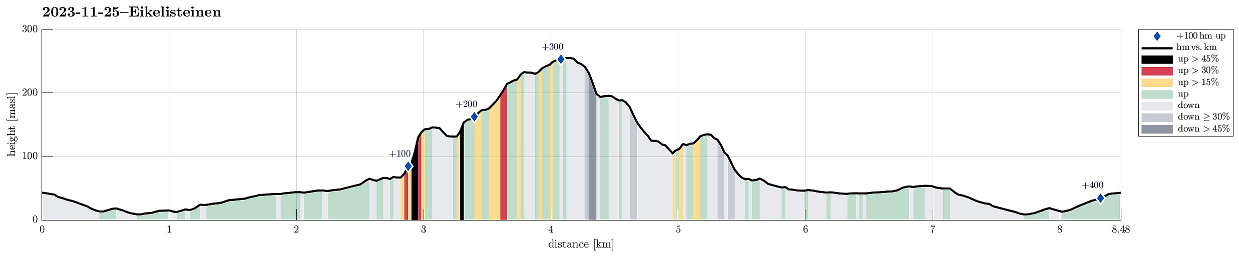 We started on our eBikes, first riding north into Fyllingsdalen, and then to Spelhaugen. At the northern end of Spelhaugen, we left our bikes behind, and continued on foot. Instead of following the main route (up the gravel road, into the direction of Tennebekk), we turned right "at once" (into the direction of Lurane in the northeast of Spelhaugen). Even there, we decided that we were up to choosing a quite steep route up (without a trail). Quite soon, we had made some height meters and, turning around, we could enjoy some nice views across Spelhaugen. Once on the heights, we traversed over to the southern end of Eikelia. Instead of following the more usual route (first northwards on the western side of Eikelifjellet's western cliff), we went around the wet area in the south >>>
Lyderhorn from Loddefjord
- Dato:
- 18.11.2023
- Turtype:
- Blandet sykling
- Turlengde:
- 2:00t
- Distanse:
- 15,0km
 To get some fresh air on this Saturday, we took our eBikes and biked to Loddefjord. In the west of Skarpafjellet, we took a side road up to the transformer station (west of Grøvledalen). From there we followed the trail up to the saddle in the north of Skarpafjellet, following the trail towards Lyderhorn from there. For the ascent to Lyderhorn, we chose the route via Små Lyderhorn, while we then descended along the trail a bit further in the east. Once down from Lyderhorn, again, we basically followed the same trail back to our bikes that we had taken up, first. Always nice to make a trip to Lyderhorn! :-)
Selected photos are available as Google photo album .
See also the related FB-page Hiking around Bergen, Norway .
Petter Bjørstad has a useful page about Lyderhorn and also web page WestCoastPeaks.com provides useful information about Lyderhorn and Ørnafjellet .
To get some fresh air on this Saturday, we took our eBikes and biked to Loddefjord. In the west of Skarpafjellet, we took a side road up to the transformer station (west of Grøvledalen). From there we followed the trail up to the saddle in the north of Skarpafjellet, following the trail towards Lyderhorn from there. For the ascent to Lyderhorn, we chose the route via Små Lyderhorn, while we then descended along the trail a bit further in the east. Once down from Lyderhorn, again, we basically followed the same trail back to our bikes that we had taken up, first. Always nice to make a trip to Lyderhorn! :-)
Selected photos are available as Google photo album .
See also the related FB-page Hiking around Bergen, Norway .
Petter Bjørstad has a useful page about Lyderhorn and also web page WestCoastPeaks.com provides useful information about Lyderhorn and Ørnafjellet .
Biking to and from Krambua
- Dato:
- 08.10.2023
- Turtype:
- Sykkeltur
- Turlengde:
- 1:30t
- Distanse:
- 17,6km
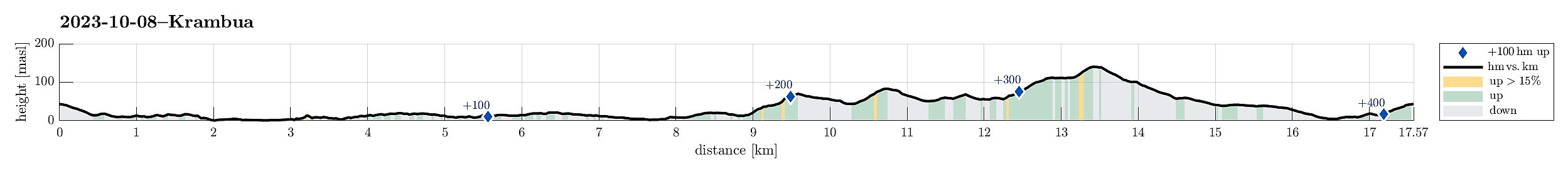 We started with the assumption that there was a joint hike agreed upon, starting from Krambua. After refilling some air, we biked along Sælevatnet and Nordåsvatnet to Krambua (just to find out that, yes, there was an agreement to hike, but not for this Sunday! :-)). We thus took our bikes back home, including a bit of a detour (first up through Langeskogen, then via Bønes to Fyllingsdalen). Altogether a nice bike-ride in nice weather! :-)
See also the related FB-page Hiking around Bergen, Norway .
We started with the assumption that there was a joint hike agreed upon, starting from Krambua. After refilling some air, we biked along Sælevatnet and Nordåsvatnet to Krambua (just to find out that, yes, there was an agreement to hike, but not for this Sunday! :-)). We thus took our bikes back home, including a bit of a detour (first up through Langeskogen, then via Bønes to Fyllingsdalen). Altogether a nice bike-ride in nice weather! :-)
See also the related FB-page Hiking around Bergen, Norway .
Saturday walk to Knappen
- Dato:
- 07.10.2023
- Turtype:
- Fjelltur
- Turlengde:
- 1:00t
- Distanse:
- 4,8km
 One of our afternoon walks to Knappen, enjoying some nice weekend weather. While we stepped up along one of our more usual routes (via Sandeidbrotet, continuing to Knappen via Eldtona), we chose a partially off-trail route down to Knappenveien. Good to get a bit of fresh air! :-)
See also the related FB-page Hiking around Bergen, Norway .
Petter Bjørstad has a useful page about Knappen .
Web page UT.no from the Norwegian Trekking Association recommends another hike to Knappen .
One of our afternoon walks to Knappen, enjoying some nice weekend weather. While we stepped up along one of our more usual routes (via Sandeidbrotet, continuing to Knappen via Eldtona), we chose a partially off-trail route down to Knappenveien. Good to get a bit of fresh air! :-)
See also the related FB-page Hiking around Bergen, Norway .
Petter Bjørstad has a useful page about Knappen .
Web page UT.no from the Norwegian Trekking Association recommends another hike to Knappen .
