Archiv - Nach Datum
Archiv - Nach Aktivität
-
Andere Tour (1)
- Kayaking (1)
-
Andere Wintertour (4)
- Schneeschuhtour (4)
-
Fahrradtour (137)
- Fahrradtour Straße (9)
- Fahrradtour gemischt (51)
-
Fußtour (740)
- Bergtour (363)
- Jogging (18)
- Spaziergang (89)
- Wanderung (270)
-
Skitour (4)
- Tourenskilauf (4)
Archiv - Nach Geografie
Peakbookfreunde


Gesammelte Listen
-
Bergen ≥ 50m pf. og ≥ 100 m.o.h.
(87/89)
 97%
97% -
Most dominating tops of the Bergen peninsula
(68/75)
90%
-
Utvalgte topper og turmål i Bergen
(316/350)
90%
-
Alle topper i Bergen
(357/398)
89%
-
Opptur Bergen
(100/113)
88%
-
De syv fjell rundt Bergen
(6/7)
85%
-
Sund ≥ 50m pf.
(14/18)
77%
-
Os ≥ 50m pf.
(25/34)
73%
-
Søyler (fastmerker) i Bergen
(68/100)
68%
-
Fjell ≥ 50m pf.
(21/32)
65%

Grosser & Kleiner Sonnstein
- Datum:
- 06.07.2015
- Tourcharakter:
- Bergtour
- Tourlänge:
- 3:00h
- Entfernung:
- 5,5km
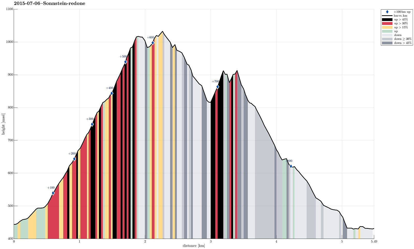 We started with two cars, leaving one a small parking spot south of Traunkirchen (if you drive from north, for ex., Gmunden, in the driection of Bad Ischl, then you first cut short Traunkirchen through a tunnel -- shortly afterwards you pass through a very short new tunnel and then the parking spot is on the right). Then we drove further, with the other car, towards Ebensee. As soon as we entered Ebensee, even before crossing the Traun, we turned right at the first opportunity (onto Hauptstrasse). After only a short distance -- basically at the first regular option to turn right, again -- we turned right (onto Langbarthstrasse). From there, we turn right again, into Kirchengasse -- this turn is not obvious (the turn is very sharp and Kirchengasse is very narrow). Right next to the church >>>
Hochleckenhaus (Höllengebirge)
- Datum:
- 06.08.2014
- Tourcharakter:
- Bergtour
- Tourlänge:
- 4:00h
- Entfernung:
- 12,1km
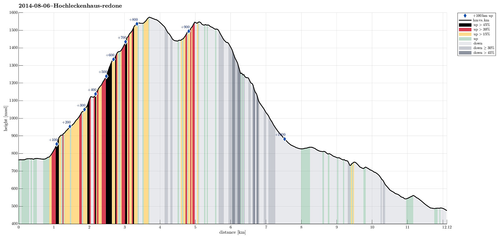 Starting from Taferlklaussee (763m), we first ascended to Hochleckenhaus (1574m) via a well-marked path (note: the start is somehow unclear -- mostly due to many other small trails near and around Taferlklausssee). After a nice and refreshing rest at Hochleckenhaus -- yes, with served food and drinks! :-) -- we descended towards Steinbach am Attersee (via Geissalm and Stieg -- the 2nd option for hiking to Steinbach), which offers terrific views -- not at the least to Attersee! The path down from Höllengebirge is (partially) steep and it's hundreds of meters straight down next to the path in selected places (you better are not afraid of heights there). All in all, a great hike! :-)
Selected photos are available as a Google photo album .
Starting from Taferlklaussee (763m), we first ascended to Hochleckenhaus (1574m) via a well-marked path (note: the start is somehow unclear -- mostly due to many other small trails near and around Taferlklausssee). After a nice and refreshing rest at Hochleckenhaus -- yes, with served food and drinks! :-) -- we descended towards Steinbach am Attersee (via Geissalm and Stieg -- the 2nd option for hiking to Steinbach), which offers terrific views -- not at the least to Attersee! The path down from Höllengebirge is (partially) steep and it's hundreds of meters straight down next to the path in selected places (you better are not afraid of heights there). All in all, a great hike! :-)
Selected photos are available as a Google photo album .
