Arkiv - dato
Arkiv - aktivitet
-
Annen tur (1)
- Kajakkpadling (1)
-
Annen vintertur (4)
- Trugetur (4)
- Fottur (740)
-
Skitur (4)
- Fjellskitur (4)
-
Sykkeltur (137)
- Blandet sykling (51)
- Gatesykling (9)
Arkiv - Etter geografi
"Peakbookvenner"


Lister jeg samler etter
-
Bergen ≥ 50m pf. og ≥ 100 m.o.h.
(87/89)
 97%
97% -
Most dominating tops of the Bergen peninsula
(68/75)
90%
-
Utvalgte topper og turmål i Bergen
(316/350)
90%
-
Alle topper i Bergen
(357/398)
89%
-
Opptur Bergen
(100/113)
88%
-
De syv fjell rundt Bergen
(6/7)
85%
-
Sund ≥ 50m pf.
(14/18)
77%
-
Os ≥ 50m pf.
(25/34)
73%
-
Søyler (fastmerker) i Bergen
(68/100)
68%
-
Fjell ≥ 50m pf.
(21/32)
65%

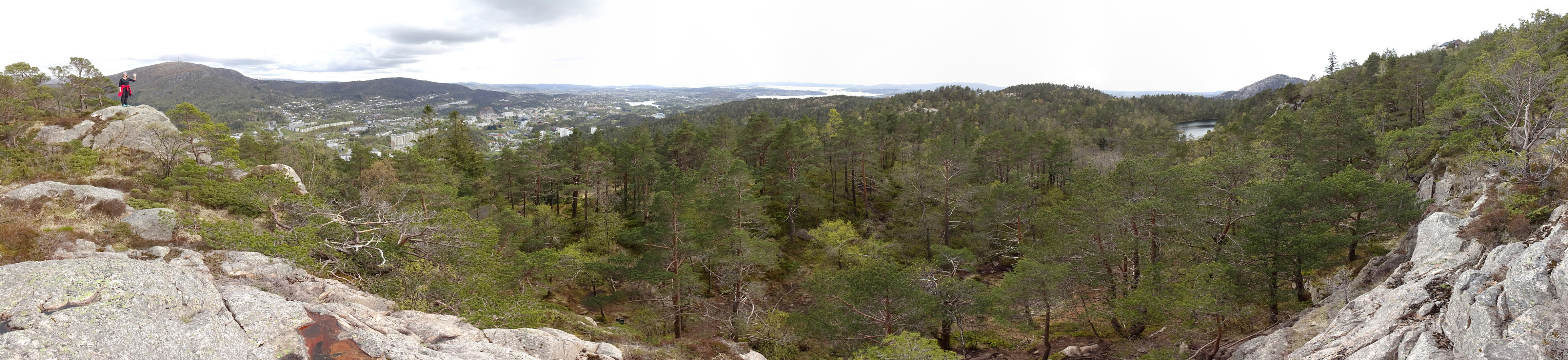
Tunesfjellet and Skåldalsfjellet
- Dato:
- 21.05.2020
- Turtype:
- Fottur
- Turlengde:
- 4:30t
- Distanse:
- 12,2km
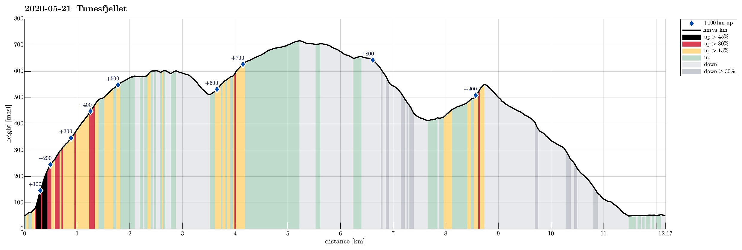 One could say that this hike is a logical continuation of our small research project Gullfjellet from the north, Sørfjorden . :-) We drove from Bergen to Arna and then through the tunnel under Ådnanipa (E16), before taking the very first exit ("Takvam") and turning back along the old road (Tunesvegen) into the direction of Tunes. At Tunestveit, only a few meters from the E16-exit, we parked along the road. We then crossed under E16 (right where it comes out of the tunnel under Ådnanipa, crossing over Tveitaelva there) and continued on an old forest road into the direction of Åsen. All the terrain is very steep there and most parts will not provide any opportunity to continue all the way up. Our map study, however, had suggested that ascending to Åsen on the very eastern side >>>
Gravdalsfjellet from Betanien
- Dato:
- 18.05.2020
- Turtype:
- Fjelltur
- Turlengde:
- 1:00t
- Distanse:
- 3,7km
 To get some fresh air, we decided to make a short hike up Gravdalsfjellet. We started at Betanien near Vestlund in Fyllingsdalen, Bergen, and head first northwards before then turning left (westwards) into the direction of Gravdalsfjellet. Right after passing by Brattheim, we took the stairs up into the direction of Viggohytten. As soon as we came out on top, however, we made a short detour to visit Kjerringen på Nipen, from where one can enjoy excellent views over Fyllingsdalen. We then headed back to the trail and up to Viggohytten before we continued further upwards to visit near Gravdalsfjellet. From there, we took another trail down (in the west of Gravdalsfjellet. After this short detour, we connected back with the trail that we had taken up near Brattheim. From there, it was >>>
Herlandsfjellet from Herland
- Dato:
- 10.05.2020
- Turtype:
- Fottur
- Turlengde:
- 3:45t
- Distanse:
- 11,0km
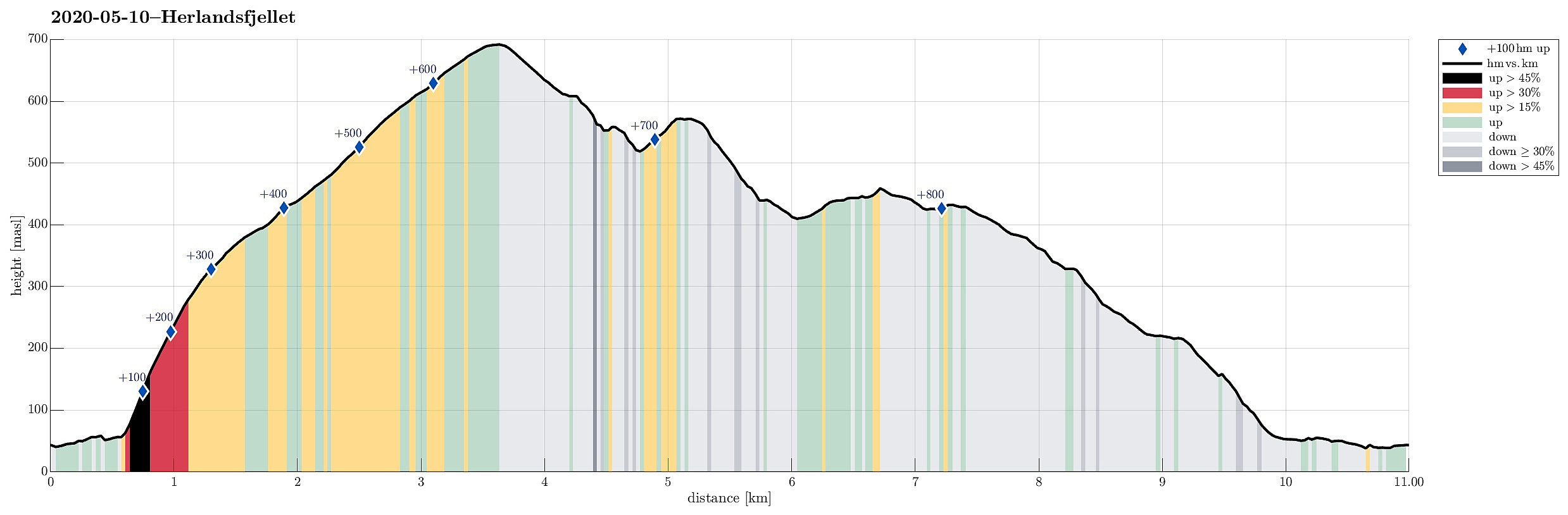 For a longer time already, we had the idea to try Herlandsfjellet from its northern side. When studying the available maps, it's not so obvious, how this should be done (as no trails are to be seen from the north). After some investigation, we were left with two choices that we deemed possible: going up from Ytre Songstad (along a narrow ridge that is very steep on either side) or going up from Herland, where the bridge to Osterøy is anchored (a less pronounced while also steep ridge). Eventually, looking at satellite images suggested that the eastern variant (from Ytre Songstad) would be through a dense looking forest, while the western variant (from Herland) appeared to have less dense standing trees. Since we were unsure how difficult it would be to ascend through a relatively dense >>>
Hamrefjellet
- Dato:
- 09.05.2020
- Turtype:
- Fjelltur
- Turlengde:
- 2:00t
- Distanse:
- 7,6km
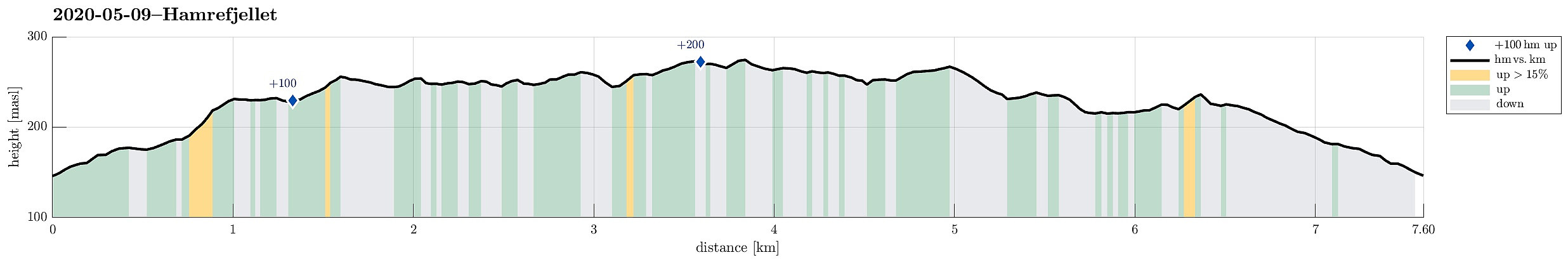 Between two visits of shops, we wished to get some fresh air. Since we were close already, we decided to go a quick round around Hamrefjellet. Since we wished to start with Tornetfjellet, we drove into the direction of Smørås (just to find out that parking is non-trivial there -- clearly, those who live there do not like hikers to park up there). We thus parked quite a bit longer down along Smøråsvegen and walked back up from there. We then ascended Torneberget from Smøråsvegen (only a few meters up), before continuing along a nice trail that stretches over the heights into southern direction (towards Hamrefjellet). Passing by Myrasmettet, we ascended Vardane (also only a few meters up). We next thought to take a look at Vallastølen. Instead of walking "down" to Militærvegen, >>>
Høgstefjellet and Veten i Åsane
- Dato:
- 25.04.2020
- Turtype:
- Fottur
- Turlengde:
- 4:00t
- Distanse:
- 9,2km
 With a nice day ahead of us (but limited time), we decided to try a hike that we had thought about for a longer time already: combining Høgstefjellet and Veten i Åsane -- a plan not without challenges (Norgeskart does not show any trail that would connect the saddle between Høgstefjellet and Tellevikafjellet and Postvegen in the valley)! In order to start with Høgstefjellet, we parked along Dalavegen on the western side of Langavatnet. The idea was to ascend towards the ridge that leads up to Varden (in the south of Høgstefjellet). Within a few minutes, we had come to a nice ridge (above Linosa), ascending steeply from its eastern side. We knew that a bit further westwards a trail was marked on the map, but we thought that we could equally well ascend along the ridge as long as this >>>
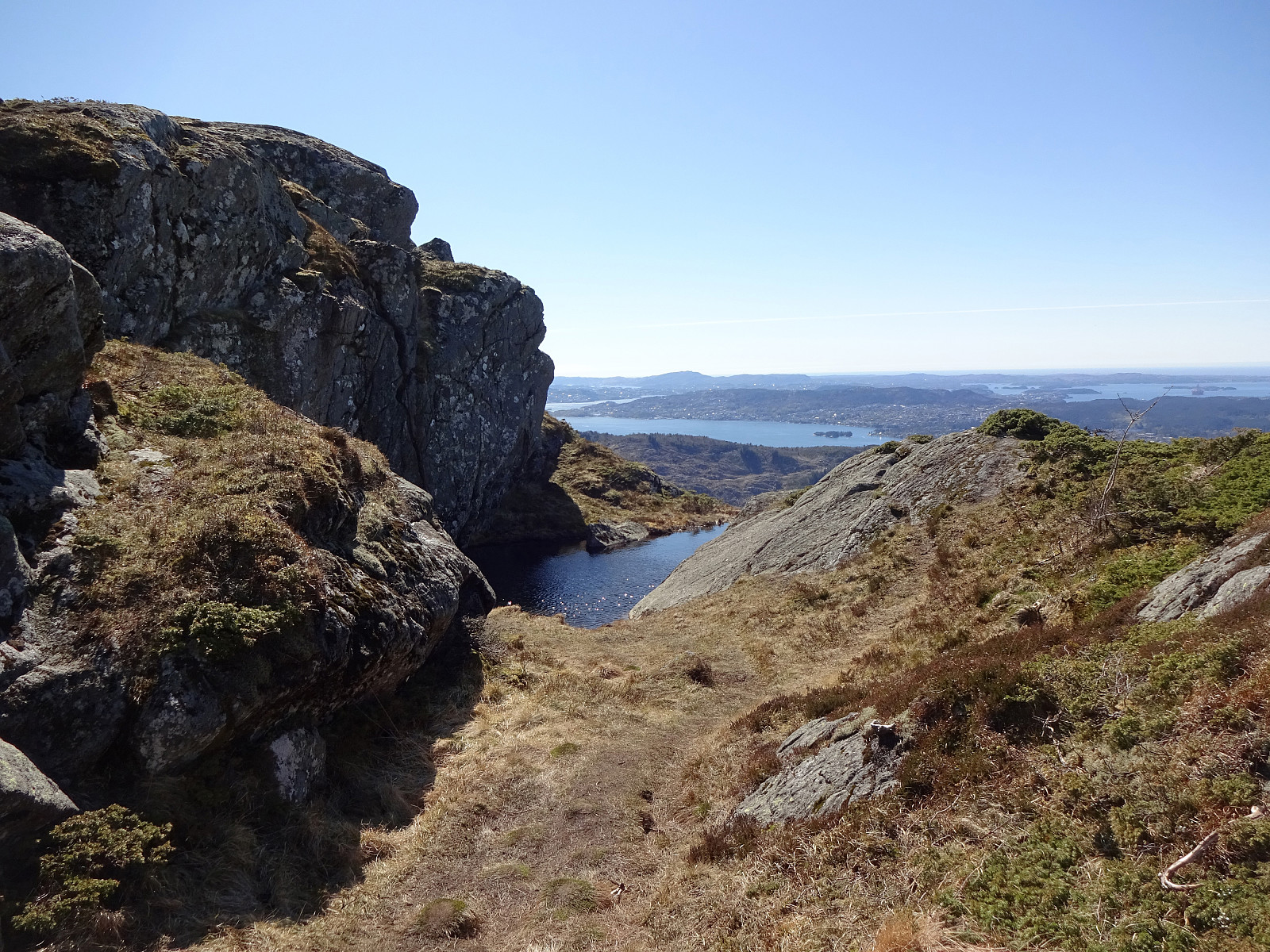
Stangfjellet and Vedafjellet
- Dato:
- 19.04.2020
- Turtype:
- Fottur
- Turlengde:
- 5:30t
- Distanse:
- 14,9km
 With a nice day ahead of us, we decided to try a hiking round, which we had looked at already repeatedly over several years, including Stangfjellet and Vedafjellet on Osterøy. After some consideration of the available time, etc., we decided to start from Gjerdstad. After leaving E16 for the bridge to Osterøy, we crossed over and used the tunnel on the other side (into the direction of Lonevåg). Following street 566 further upwards, we turned right near Rolland, continuing on Gjerdstadvegen. After some 5km, or so, we came to Gjerdstad, seeing the church there prominently on the right side. Turning right and crossing the stream using the narrow bridge there, we were right at the church and parked there. Before even starting our hike, we first looked at a large memorial stone, opposide >>>
Wild Golta
- Dato:
- 13.04.2020
- Turtype:
- Fjelltur
- Turlengde:
- 3:00t
- Distanse:
- 5,1km
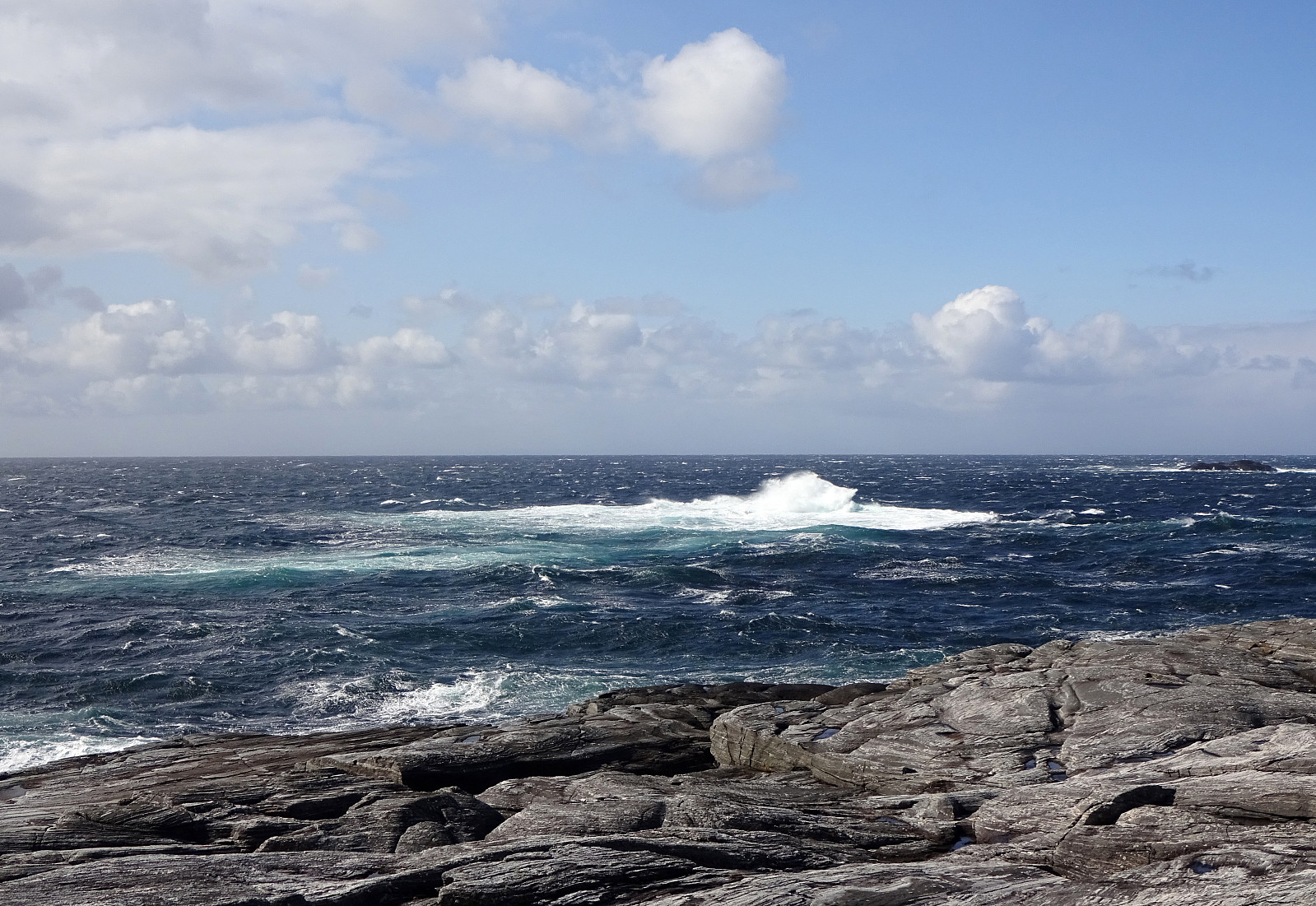 The weather forecast was "interesting": 3 or 4 degrees Celsius and strong winds from the north (with gale warnings nearby). Sounds like a nice day for another trip to the outer islands! :-) This time, we chose Golta (south of Telavåg and west of Glesvær), which is wild and nice! We parked at the parking lot near the inner end of Vogga and started our short hike from there. The route is trivial to find and also not very long. Within a few minutes one gets out to the wild rocks near the North Atlantic. And clearly we weren't disappointed (again): very impressive, when the wind works the sea so hard! We walked for a longer while around the rocks and enjoyed the atmosphere, rounding Lutavika and then also Midtvika, before heading back. Even though a shorter trip, it's definitely >>>
Brakstadfjellet, Tveitanipa, and Røysetfjellet
- Dato:
- 10.04.2020
- Turtype:
- Fottur
- Turlengde:
- 3:30t
- Distanse:
- 9,2km
 The weather report suggested the further north one may have better chances for some sunshine. So, a top, which had been waiting on our wish-list for a long time already, got picked as trip goal: Brakstadfjellet. The car brought us north from Bergen and over Nordhordlandsbrua. Turning left at Flatøy brings one over the bridge over Krossnessundet onto Holsnøy. Following road 564, we passed Frekhaug into the direction of Fløksand. Near Holme, we turned right (onto road 5314), driving further to Tveit. Eventually using road 5308, we ended up near Brakstadvatnet at Vollo. There, a somewhat extended bus stop offers good opportunities for parking. Before starting from Bergen, we had checked the map in order to understand, which alternatives there are for ascending to Brakstadfjellet. This >>>
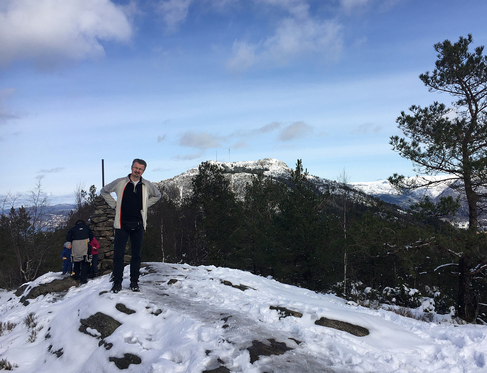
Erstadfjellet and Hånipa
- Dato:
- 09.04.2020
- Turtype:
- Fottur
- Turlengde:
- 4:15t
- Distanse:
- 11,7km
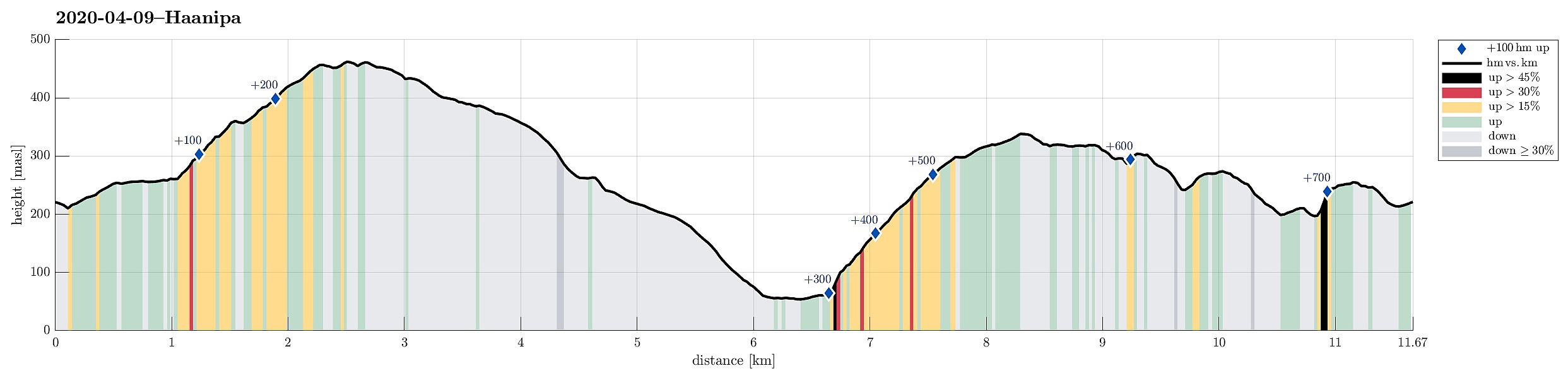 Trying to find a good spot for social distancing in this "special year" 2020, we aimed at the very west of Osterøy. The one little height, which we still had on our wish-list, Hånipa, with its apparently very steep western side, attracted us (for a longer time already) with a promise of nice views down to Sørfjorden. To make this a nice round, we parked near Askeland, about 200 height-meters above Votlo. From there, we first walked into Askelandsdalen (in eastern direction), before ascending relatively steeply to Setleitet (with some nice views down to Askelandsvatnet on the other side). Turning left, we started our ascent to Erstadfjellet (via Merkjedalsstølen). Crossing over Erstadfjellet, and only spending a few minutes up there to enjoy some nice views across Sørfjorden >>>
Short round over Gullsteinen
- Dato:
- 04.04.2020
- Turtype:
- Fjelltur
- Turlengde:
- 1:30t
- Distanse:
- 3,9km
 With a little bit of time left, we decided to make a short detour across Gullsteinen. We parked along Nils Langhelles vei and walked up one of its steep side roads first. Near house #22, we had come to the end of this side road. Fortunately, it was possible to ascend up towards the next side road. From there, where this other side road makes a sharp turn to the south, it was then only a few meters, before a trail leaves to the left. Stepping up through the forest there, we first ascended a micro-hill south of Strutsefarmen. From there, we turned back to the trail, which leads up to the ridge between Gullsteinen and Løvstakken. Instead of following the trail, however, we decided to step up "through the wild" (and in the not all-too-deep snow). Lovely, to get out into some >>>
