Archiv - Nach Datum
Archiv - Nach Aktivität
-
Andere Tour (1)
- Kayaking (1)
-
Andere Wintertour (4)
- Schneeschuhtour (4)
-
Fahrradtour (137)
- Fahrradtour Straße (9)
- Fahrradtour gemischt (51)
-
Fußtour (740)
- Bergtour (363)
- Jogging (18)
- Spaziergang (89)
- Wanderung (270)
-
Skitour (4)
- Tourenskilauf (4)
Archiv - Nach Geografie
Peakbookfreunde


Gesammelte Listen
-
Bergen ≥ 50m pf. og ≥ 100 m.o.h.
(87/89)
 97%
97% -
Most dominating tops of the Bergen peninsula
(68/75)
90%
-
Utvalgte topper og turmål i Bergen
(316/350)
90%
-
Alle topper i Bergen
(357/398)
89%
-
Opptur Bergen
(100/113)
88%
-
De syv fjell rundt Bergen
(6/7)
85%
-
Sund ≥ 50m pf.
(14/18)
77%
-
Os ≥ 50m pf.
(25/34)
73%
-
Søyler (fastmerker) i Bergen
(68/100)
68%
-
Fjell ≥ 50m pf.
(21/32)
65%

Skogsøy, always impressive!
- Datum:
- 27.07.2024
- Tourcharakter:
- Wanderung
- Tourlänge:
- 5:00h
- Entfernung:
- 5,7km
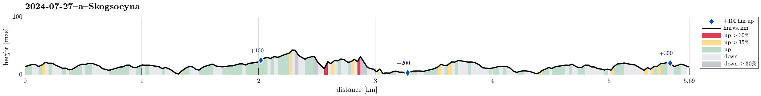 Skogsøy is always ("always") a good idea! :-) We parked near the bridge to Herdlevær and followed the main trail to Skogsøytua. There, we explored the wild cliffs before then taking the southern route back to Mjelkevik. From there, we then followed the main trail back to the car. While Skogsøy is no longer as secret a tip as it was before, it's still a very nice hike to an impressive place (where "the last resort" of Norwegian land meets the open North Atlantic)!
Selected photos are available as Google photo album .
See also the related FB-page Hiking around Bergen, Norway .
Web page UT.no from the Norwegian Trekking Association recommends a similar hike .
Skogsøy is always ("always") a good idea! :-) We parked near the bridge to Herdlevær and followed the main trail to Skogsøytua. There, we explored the wild cliffs before then taking the southern route back to Mjelkevik. From there, we then followed the main trail back to the car. While Skogsøy is no longer as secret a tip as it was before, it's still a very nice hike to an impressive place (where "the last resort" of Norwegian land meets the open North Atlantic)!
Selected photos are available as Google photo album .
See also the related FB-page Hiking around Bergen, Norway .
Web page UT.no from the Norwegian Trekking Association recommends a similar hike .
Evening walk to Knappen
- Datum:
- 26.07.2024
- Tourcharakter:
- Bergtour
- Tourlänge:
- 1:30h
- Entfernung:
- 4,5km
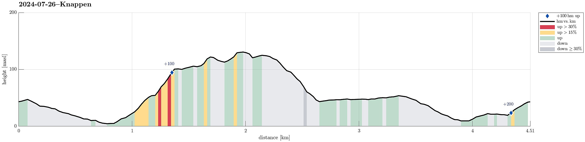 With still a couple of daylight hours to go (easy in July around here!), we decided to simply make a short round to Knappen. Evening light is actually quite nice -- also on Knappen! :-)
Selected photos are available as Google photo album .
See also the related FB-page Hiking around Bergen, Norway .
Petter Bjørstad has a useful page about Knappen .
Web page UT.no from the Norwegian Trekking Association recommends another hike to Knappen .
With still a couple of daylight hours to go (easy in July around here!), we decided to simply make a short round to Knappen. Evening light is actually quite nice -- also on Knappen! :-)
Selected photos are available as Google photo album .
See also the related FB-page Hiking around Bergen, Norway .
Petter Bjørstad has a useful page about Knappen .
Web page UT.no from the Norwegian Trekking Association recommends another hike to Knappen .
Exploring Ytrebygda a little more
- Datum:
- 24.07.2024
- Tourcharakter:
- Fahrradtour gemischt
- Tourlänge:
- 2:30h
- Entfernung:
- 27,8km
 To get some fresh air in the nice weather, I embarked on a short bike trip with a few small walking bits. I first explored Storåsen on Dolvikhaugene, just to find the "actual top" to be a bit too much within the houses around it. I then visited Skranevatnet in the southwest of Feråsen, which was a nice surprise. Next, I explored Storasåta in the north of Ytrebygsvegen. When approached from the north/northeast, one can actually find a proper trail that leads up to this small hill. Thereafter, I paid Lilandshaugen a short visit, which offers quite some nice views across the airport of Bergen. I improvised my way up, just to then find out that actually there's a convenient road (Lilandsvegen) that leads up to the vista-point. After biking around Lilandshaugen, I then checked >>>
Søtefjellet from Hausdalen
- Datum:
- 20.07.2024
- Tourcharakter:
- Wanderung
- Tourlänge:
- 6:30h
- Entfernung:
- 10,4km
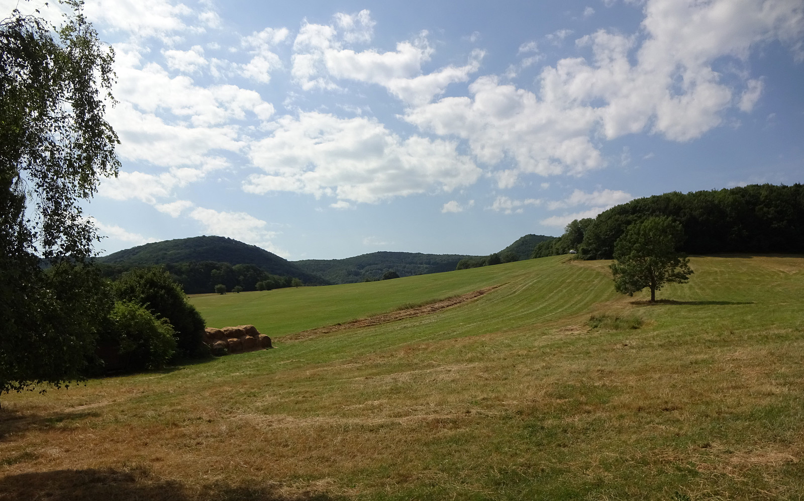
 We wished to use the nice weather on this warm Saturday afternoon and headed for Hausdalen in the southeast of Bergen. Driving Hausdalen in for a little less than 7km, we parked in the southwest of Tømmervika (Samdalsvatnet), where a forest road forks off Hausdalsvegen into the direction of Straumsrinden. Following this forest road, we passed by Samdalsvatnet in its southwest, heading for the southwestern ridge of Søtefjellet, starting at Hisbotn. Just because others have described their ascent to the small hill in the north of Ulvvatnet (and even though they did not recommend to visit it -- or maybe because of their according comments :-)), this hill was included as a prelude to the ascent to Søtefjellet. Back on the forest road, and "around some corners in the northeast of Ulvvatnet, >>>
Lattermaißberg from Wiener Hütte
- Datum:
- 16.07.2024
- Tourcharakter:
- Spaziergang
- Tourlänge:
- 1:30h
- Entfernung:
- 5,1km
 We wished to do a short, relaxed walk. Given the very warm weather, a walk in the forest seemed just right! :-)
See also the related FB-page Hiking around Bergen, Norway .
We wished to do a short, relaxed walk. Given the very warm weather, a walk in the forest seemed just right! :-)
See also the related FB-page Hiking around Bergen, Norway .
Rax from Preiner Gscheid
- Datum:
- 15.07.2024
- Tourcharakter:
- Wanderung
- Tourlänge:
- 6:30h
- Entfernung:
- 13,9km
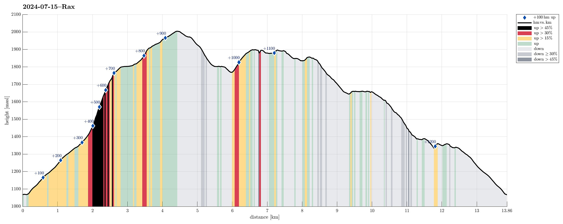 The weather looked promising (fine enough) to attempt the Rax, south of Wien. Starting early, we arrived at Preiner Gscheid (about 1070 masl) at about 8h30 in the morning. To make height meters quickly, we ascended (mostly northwards) along the skiing track that comes down in parallel to Rettenbach (in the northeast). At about 1340 masl (just a short distance from Waxrieglhaus in the east), we then entered Karlgraben in order to ascend (steeply) to Karl-Ludwig-Haus. We arrived at the Rax-heights at Thörl, before then walking over to Karl-Ludwig-Haus. From there, it's an easy stroll to Raxkircherl at Wetterkogel. Further upwards, we continued to Heukuppe via Schneegrubensattel. From there, we then returned to Karl-Ludwig-Haus, where we enjoyed a nice break with something to eat and drink. >>>
Prozor from Arapovac
- Datum:
- 10.07.2024
- Tourcharakter:
- Bergtour
- Tourlänge:
- 2:00h
- Entfernung:
- 2,4km
 We were up for a short hike, given the quite hot weather. From Arapovac, we made our way up to Prozor, mostly without any trail. To get back to Arapovac, we chose another route, also (partly) without any (proper) trail. Hiking in those parts, which are covered by some older forest, was nice and without challenges; hiking through newer forest, however, was challenging due to the extra-dense vegetation! :-)
Selected photos are available as Google photo album .
See also the related FB-page Hiking around Bergen, Norway .
We were up for a short hike, given the quite hot weather. From Arapovac, we made our way up to Prozor, mostly without any trail. To get back to Arapovac, we chose another route, also (partly) without any (proper) trail. Hiking in those parts, which are covered by some older forest, was nice and without challenges; hiking through newer forest, however, was challenging due to the extra-dense vegetation! :-)
Selected photos are available as Google photo album .
See also the related FB-page Hiking around Bergen, Norway .
Visiting the caves of Barać
- Datum:
- 09.07.2024
- Tourcharakter:
- Spaziergang
- Tourlänge:
- 2:00h
- Entfernung:
- 1,0km
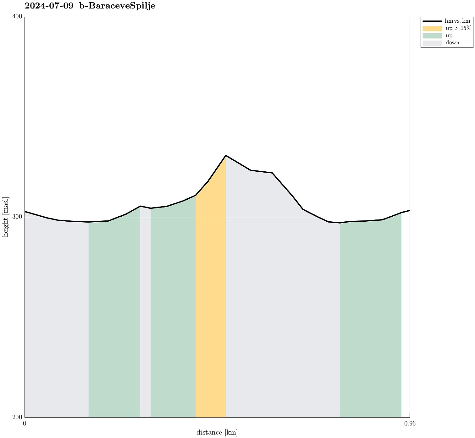 As a nice early evening program, we made a detour to see the caves of Barać. After parking at the parking lot, we walked into the "cave area" and got thoroughly impressed by the amount of effort that someone had put into setting up everything and making the whole area nice! :-) Since none else was about to take a tour, we eventually, after a bit of waiting, got a tour of the upper cave just for the four of us -- that was nice (we were told that at other times, some groups would be as large as 50, which clearly sounded too large for this cave). Our tour guide showed us around in the cave and gave us ample time to shoot our photos (since photographing was only allowed without flash, it usually took a few tries before one photo came out reasonably). After visiting the cave, we returned >>>
Visiting Kotlac near Slunj
- Datum:
- 09.07.2024
- Tourcharakter:
- Spaziergang
- Tourlänge:
- 1:00h
- Entfernung:
- 0,7km
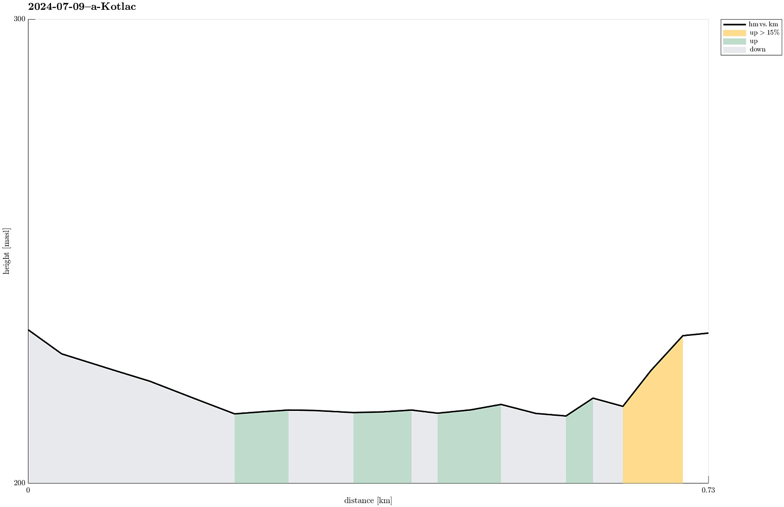 Given the warm day, we made a short excursion to Kotlac near Slunj to cool down (a little) in the lovely Korana river.
Selected photos are available as Google photo album .
See also the related FB-page Hiking around Bergen, Norway .
Given the warm day, we made a short excursion to Kotlac near Slunj to cool down (a little) in the lovely Korana river.
Selected photos are available as Google photo album .
See also the related FB-page Hiking around Bergen, Norway .
Exploring the city center of Sopron
- Datum:
- 05.07.2024
- Tourcharakter:
- Spaziergang
- Tourlänge:
- 1:00h
- Entfernung:
- 2,7km
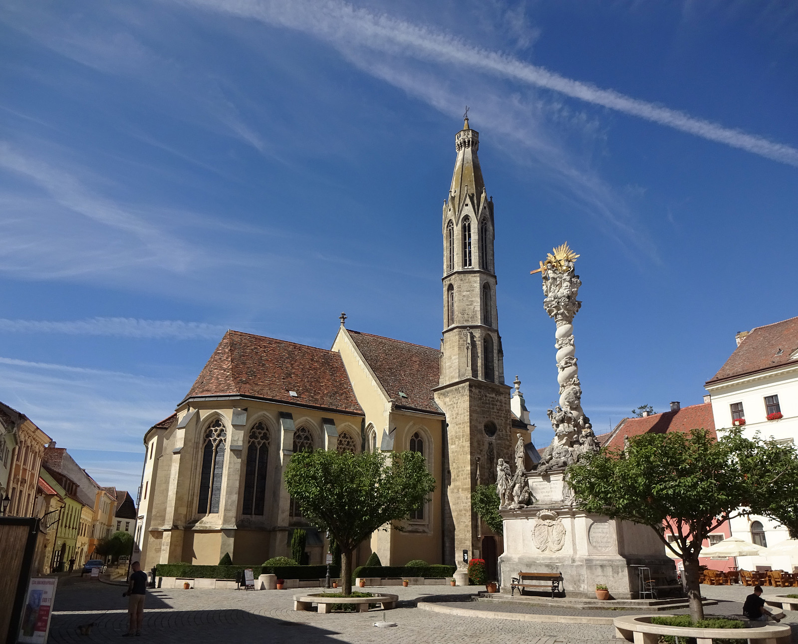 We had some spare time in Sopron, Hungary, which we used to walk around the historic center of the town. This brought us by mighty city walls, long out of their original use, the central square, as well as some unexpected sights (such as Fekete Elefánt cégér). Visiting Sopron can be recommended, even though making many height meters is difficult there! :-)
Selected photos are available as Google photo album .
See also the related FB-page Hiking around Bergen, Norway .
We had some spare time in Sopron, Hungary, which we used to walk around the historic center of the town. This brought us by mighty city walls, long out of their original use, the central square, as well as some unexpected sights (such as Fekete Elefánt cégér). Visiting Sopron can be recommended, even though making many height meters is difficult there! :-)
Selected photos are available as Google photo album .
See also the related FB-page Hiking around Bergen, Norway .
