Archiv - Nach Datum
Archiv - Nach Aktivität
-
Andere Tour (1)
- Kayaking (1)
-
Andere Wintertour (4)
- Schneeschuhtour (4)
-
Fahrradtour (137)
- Fahrradtour Straße (9)
- Fahrradtour gemischt (51)
-
Fußtour (740)
- Bergtour (363)
- Jogging (18)
- Spaziergang (89)
- Wanderung (270)
-
Skitour (4)
- Tourenskilauf (4)
Archiv - Nach Geografie
Peakbookfreunde


Gesammelte Listen
-
Bergen ≥ 50m pf. og ≥ 100 m.o.h.
(87/89)
 97%
97% -
Most dominating tops of the Bergen peninsula
(68/75)
90%
-
Utvalgte topper og turmål i Bergen
(316/352)
89%
-
Alle topper i Bergen
(357/400)
89%
-
Opptur Bergen
(100/113)
88%
-
De syv fjell rundt Bergen
(6/7)
85%
-
Sund ≥ 50m pf.
(14/18)
77%
-
Os ≥ 50m pf.
(25/34)
73%
-
Søyler (fastmerker) i Bergen
(68/100)
68%
-
Fjell ≥ 50m pf.
(21/32)
65%

Around Vassbakken Camping near Skjolden
- Datum:
- 23.07.2019
- Tourcharakter:
- Spaziergang
- Tourlänge:
- 2:00h
- Entfernung:
- 5,4km
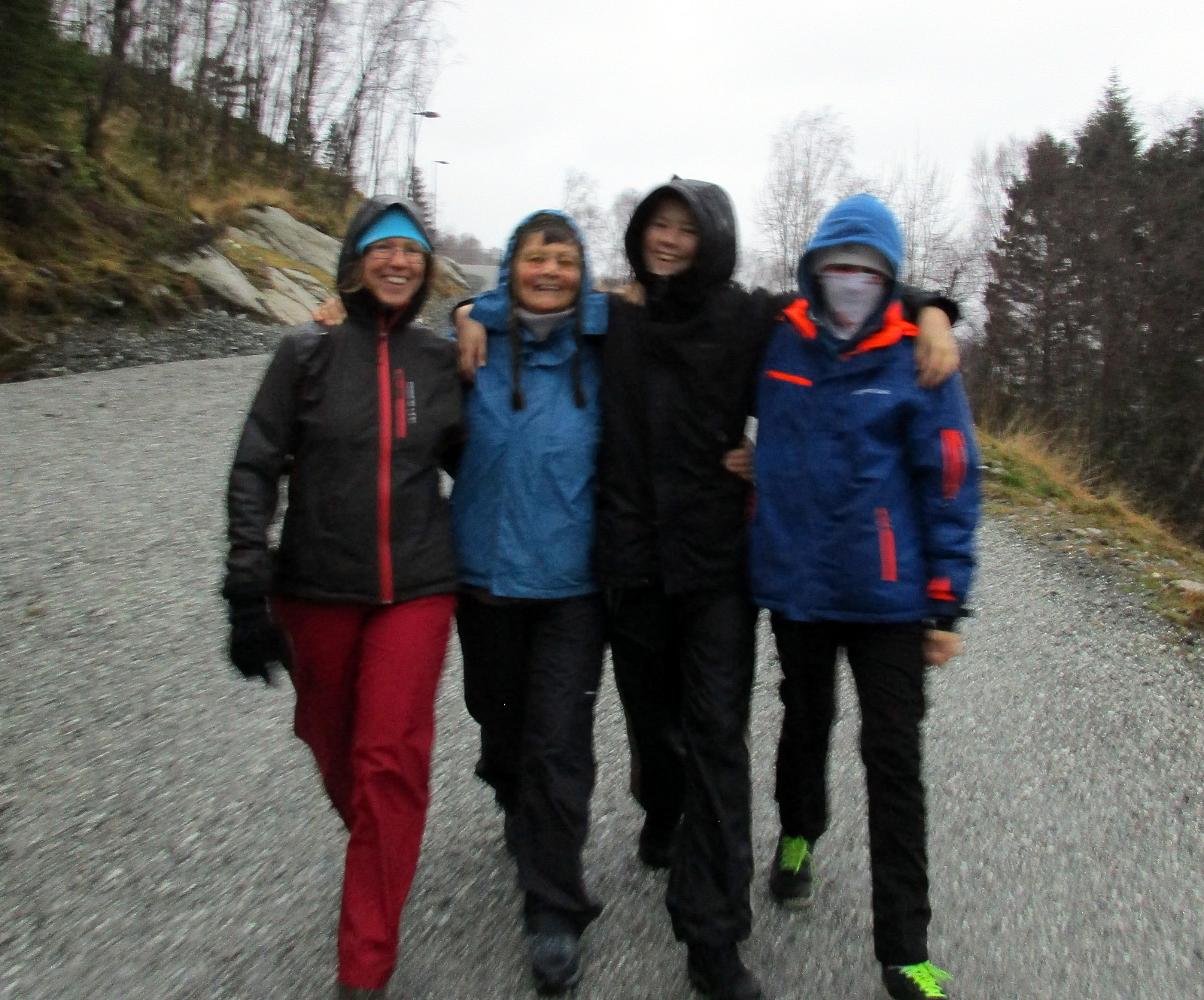
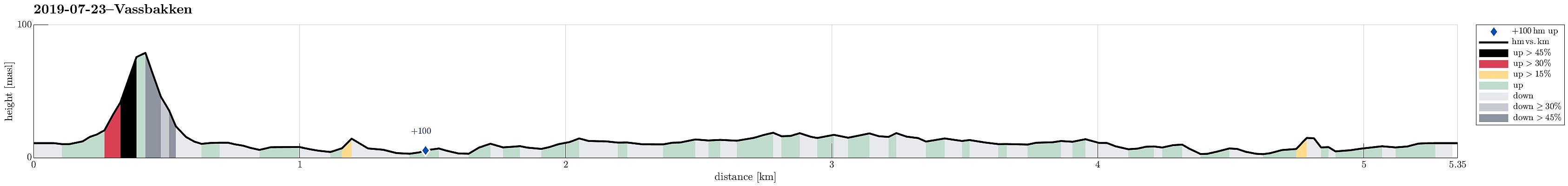 After driving from Bergen to Skjolden (for getting started with our five days hike through Breheimen), we "landed" at Vassbakken Camping in the early evening. After eating dinner, we decided to do a bit of exploration and headed into the direction of the impressive waterfall of Åselvi, first. A few minutes later, we were standing right next to it: very impressive (and easy to reach from the camping site). After stepping back down the about 80 height meters to the street (and crossing it), we continued beyond the camping site and crossed Fortunselvi on a convenient bridge. The large amounts of glacial waters had dictated this river's color and opacity: also a nice and impressive view. We then walked a little eastwards (on the northern side of Fortunselvi) to the place, where >>>
Stendörren
- Datum:
- 18.06.2019
- Tourcharakter:
- Spaziergang
- Tourlänge:
- 2:30h
- Entfernung:
- 7,9km
 After a good workshop day in Nyköping, we had the chance to see Stendörrens naturreservat in the evening. Walking along the very well marked trails, many photo opportunities emerged! :-) The complex intermingling of the forest, several islands (many of which small), and the sea makes this place (as well as others along the Swedish coast!) very attractive.
Selected photos are available as Google photo album .
See also the related FB-page Hiking around Bergen, Norway .
Stendörren is further described at a web page of Länsstyrelsen Södermanland .
After a good workshop day in Nyköping, we had the chance to see Stendörrens naturreservat in the evening. Walking along the very well marked trails, many photo opportunities emerged! :-) The complex intermingling of the forest, several islands (many of which small), and the sea makes this place (as well as others along the Swedish coast!) very attractive.
Selected photos are available as Google photo album .
See also the related FB-page Hiking around Bergen, Norway .
Stendörren is further described at a web page of Länsstyrelsen Södermanland .
Gløvrebu (Øygarden)
- Datum:
- 31.05.2019
- Tourcharakter:
- Spaziergang
- Tourlänge:
- 1:30h
- Entfernung:
- 3,0km
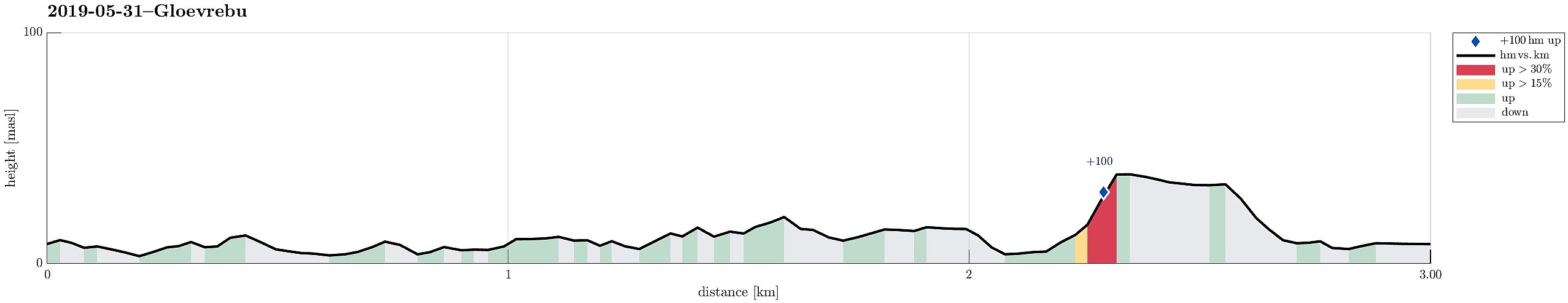 We thought about paying the open sea a visit, this evening. Leaving Bergen towards Sotra, we turned north right after Kolltveittunnelen, continuing on road 561 towards Øygarden. Driving almost all the way out (to Hellesøy), we came to Seløyna. While the road is getting really narrow there, one cannot overlook Hjelme Kyrkje, when passing by. Only meters later, right next to the rather big graveyard, we parked the car and started to follow a nice trail into the direction of Stakksvika. Close to the sea, the trail splits with the southern route being a bit more direct to Gløvrebu. Still, the slightly longer route (towards Stakksvika first) is very nice, offering views to and beyond Bobbeskjeret. From there, it's then towards the south and to Gløvrebu. While the whole area there is >>>
Rhododendron watching in Arboretet på Milde
- Datum:
- 30.05.2019
- Tourcharakter:
- Spaziergang
- Tourlänge:
- 1:30h
- Entfernung:
- 4,1km
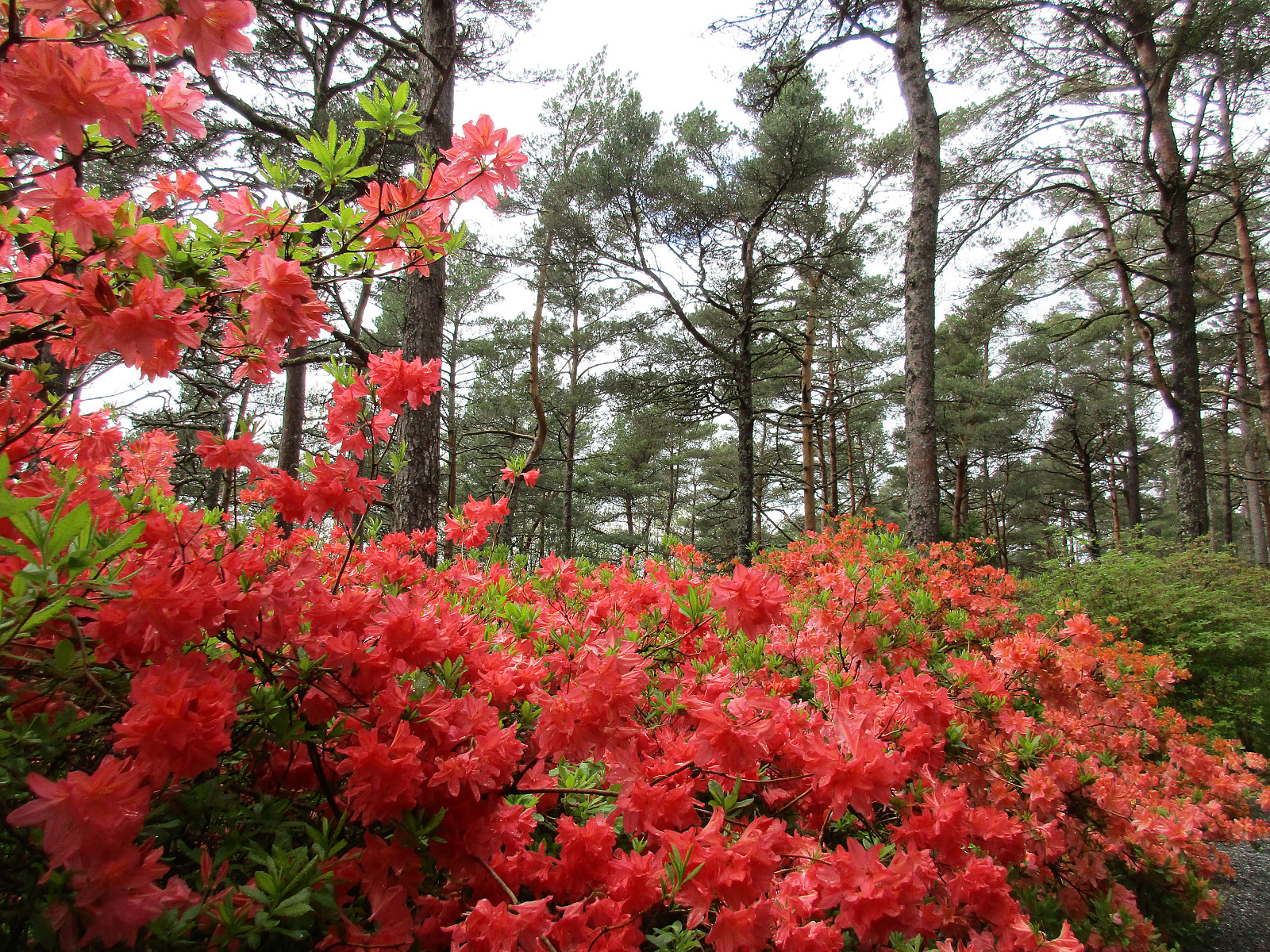 We had a bit of extra time and thought that visiting Arboretet på Milde and seeing some blossoming Rhododendra would be nice. :-) We parked at Grønneviken parking (northwest of Arboretet) and started with a nice walk into Arboretet from the northwest. Before getting into the middle of it, we turned left onto a small trail that passes by Mørkevatnet (in its south) with some nice views. From there, we continued (in northern direction) to see the collection of Rhododendra that is placed into the forest there. And sure enough we were not disappointed, being overwhelmed by loads of bright colors! After enjoying this part of Arboretet for a good while, we returned towards its middle (Blondehuset) and from there we continued further into the south of Arboretet, into the direction of the (still >>>
Short hike over Vardafjellet
- Datum:
- 12.04.2019
- Tourcharakter:
- Spaziergang
- Tourlänge:
- 0:30h
- Entfernung:
- 1,4km
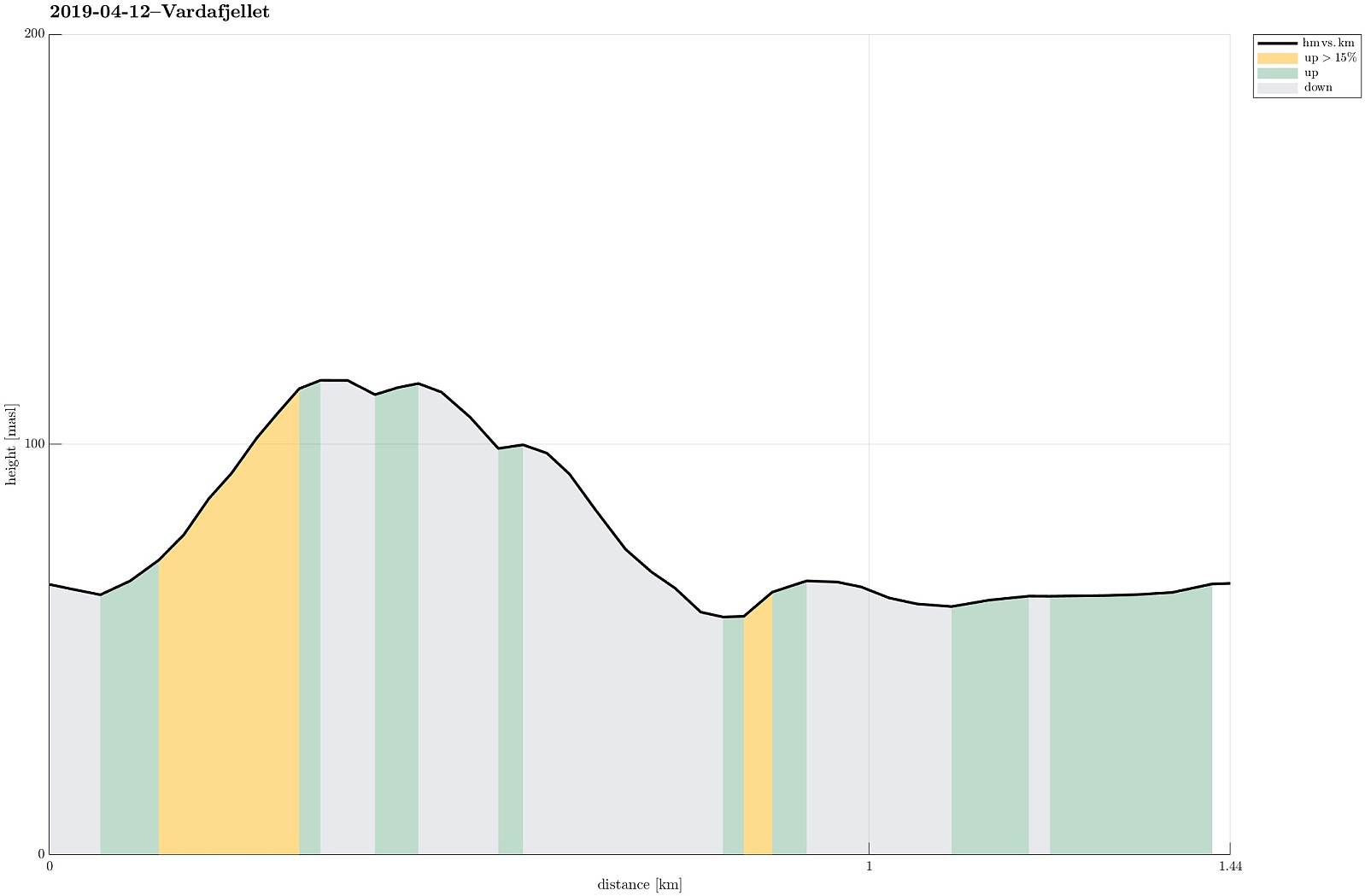 After a meeting at Solstrand, I was heading to another meeting in Bergen. Given the beautiful day and half an hour to spare, I decided to include a quick walk over one of the minor peaks near Osøyro: Vardafjellet. I drove up to Øvre Varåsen and found a place to park for half an hour. My plan was then to continue to Varåsgrenda and to take a trail from there (as I had seen it on the map). Walking north on Øvre Varåsen, however, I turned left one street too early. Soon, I understood that this would not lead to the trail, but since I thought that ascending to Vardafjellet should not be too difficult, even without a trail, I continued and indeed found a reasonable opportunity at the back of house 48 (southwest of it). Within a few minutes, I had connected to the trail and then followed >>>
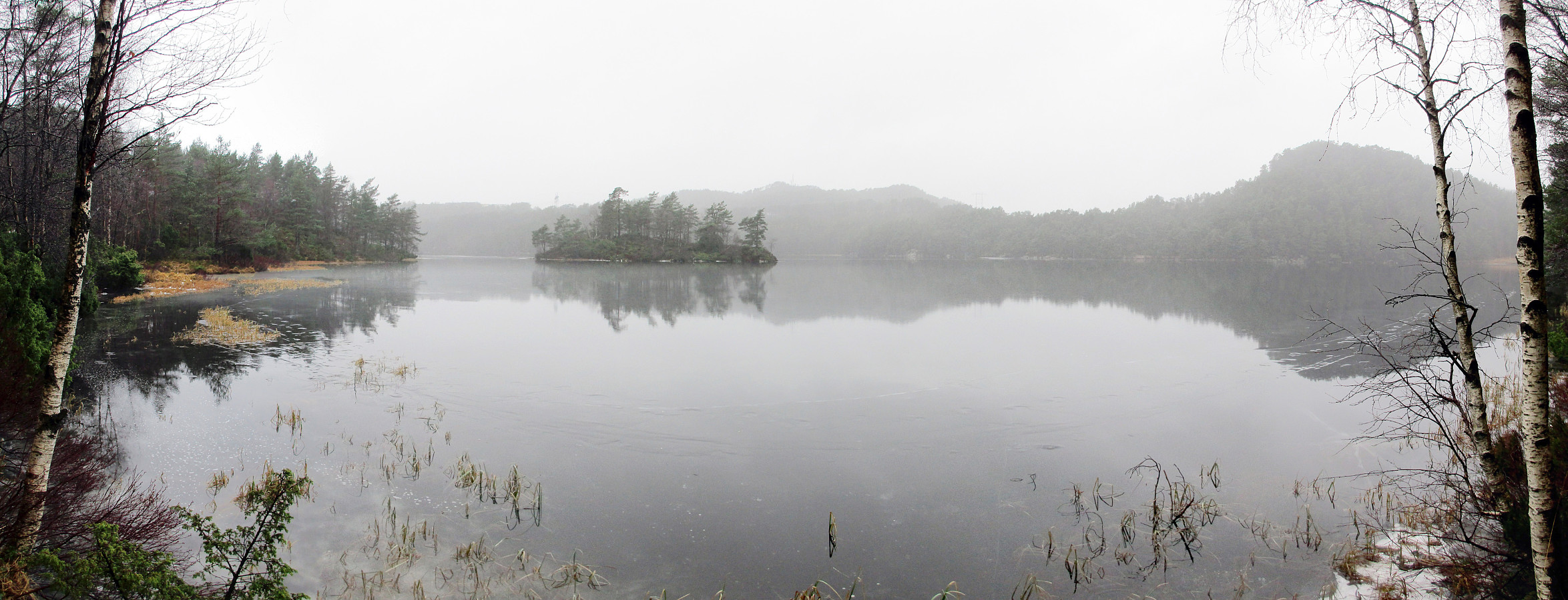
Along Sælevatnet
- Datum:
- 12.03.2017
- Tourcharakter:
- Spaziergang
- Tourlänge:
- 0:45h
- Entfernung:
- 2,3km
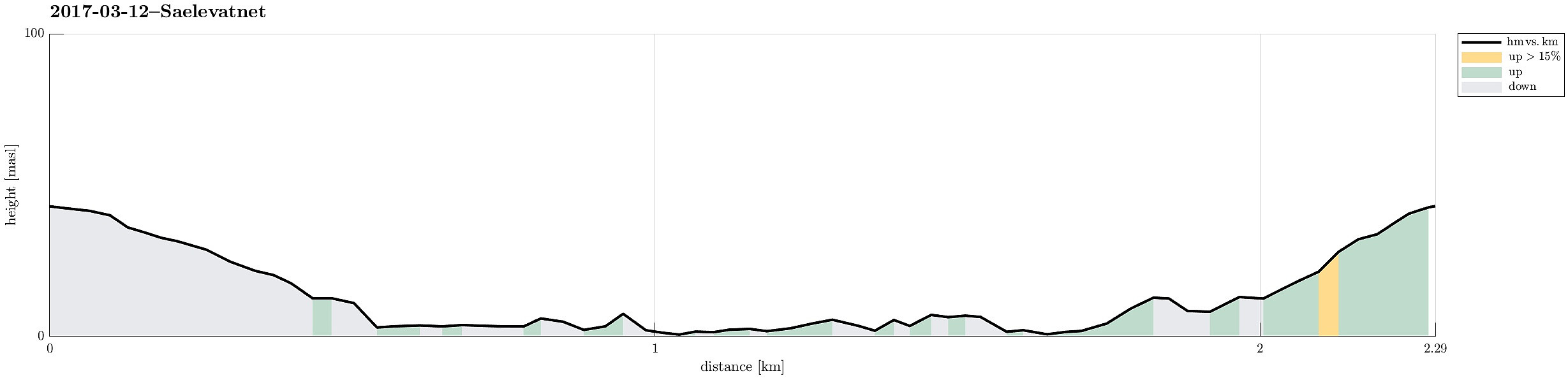 I started from Varden and got down from Vardeveien to Fyllingsdalsveien near the bridge, which crosses over Fyllingsdalsveien from Vardeveien (and over to Skitnakastet). After crossing Fyllingsdalsveien, I quickly descended towards Sælevatnet. Then, I followed the shoreline, first in southern direction, following the outer edge of this small peninsula, separated from "the rest of the world" by Fyllingsdalsveien. After having completed this surrounding, I got back to Skitnakastet, where I took the small bridge back to Vardeveien. From there, it was then only a few meters back to the start.
Selected photos are available as Google photo album .
See also the related FB-page Hiking around Bergen, Norway .
I started from Varden and got down from Vardeveien to Fyllingsdalsveien near the bridge, which crosses over Fyllingsdalsveien from Vardeveien (and over to Skitnakastet). After crossing Fyllingsdalsveien, I quickly descended towards Sælevatnet. Then, I followed the shoreline, first in southern direction, following the outer edge of this small peninsula, separated from "the rest of the world" by Fyllingsdalsveien. After having completed this surrounding, I got back to Skitnakastet, where I took the small bridge back to Vardeveien. From there, it was then only a few meters back to the start.
Selected photos are available as Google photo album .
See also the related FB-page Hiking around Bergen, Norway .
Arboretet in Milde
- Datum:
- 11.09.2016
- Tourcharakter:
- Spaziergang
- Tourlänge:
- 2:00h
- Entfernung:
- 4,7km
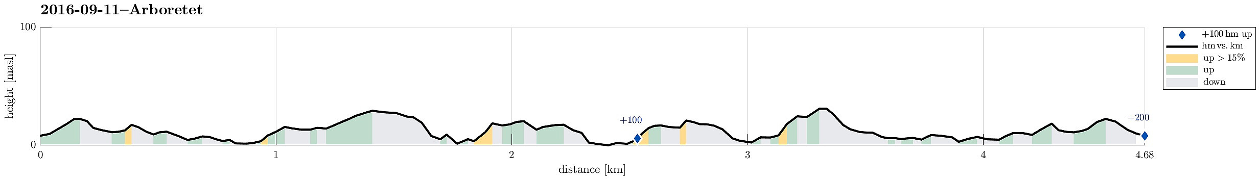 We parked at the Dalsmyra parking at the northwestern end of the arboretum. From there, it's an easy walk along a simple forrest road (mostly eastwards, first), before one gets into the heart of the arboretum. After passing a covered sitting area, we turned left---circling halfways around Mørkevatnet (with some nice views over this little lake). We then ascended the few meters upwards to enter the garden with many different Rhododendron-plants. After having enjoyed some nice views over Vestrepollen in the northwest, we turned right and continued in southeastern direction towards Langemyra---there, we connected to a path the lead us outwards to Store Brandaneset. At the southeastern end of Store Brandaneset, we enjoyed a really nice place directly at the sea. From there, we then returned---first >>>
Bjørndalen
- Datum:
- 24.01.2016
- Tourcharakter:
- Spaziergang
- Tourlänge:
- 2:00h
- Entfernung:
- 7,9km
 We started from Varden and went down to Bjørgeveien, which we followed until the point, where we could leave the road towards Kjerreidvika (on the left, western side). Down at the sea, it is possible to find a narrow path on the northern side, which surrounds Ørnahaugen, passing by Djupakastet, leading to Hestabakken. There, we ascended upwards---in eastern direction---until we came close to the buildings up there. Before actually reaching the houses at Bjørndalsskogen, we turned left and crossed a small height, before stepping down into the "main square" of Bjørndalsskogen. We crossed over to the other, northern side, where we left the street, again, ascending to the hill north of Bjørndalsssskogen. After stepping over the first top, we crossed over to Kampen on the northwestern >>>
Kossdalen
- Datum:
- 02.01.2016
- Tourcharakter:
- Spaziergang
- Tourlänge:
- 2:30h
- Entfernung:
- 7,7km
 We drove to Osterøy and then on Osterøy first to Lonevåg. From there, we continued to Hosanger at Osterfjorden, on the northwestern side of Osterøy. In Hosanger, we took a sharp turn to the right, where a sign leads to the Waldorf school in Holanger. Before getting to the school, we parked right next to the graveyard. From there we walked along a simple road, first on the western side of the little stream that comes down from Holevatnet, that leads directly into Kossdalen. In Kossdalen, the path switches sides and continues further in on the eastern side of the valley, passing by Kossdalsvatnet. At the very end of Kossdalen, one finds a place called Gråura, where certainly some have enjoyed camping already---it's just a very nice place! :-) Behind Gråura, Kossdalssvingane start---an >>>
New Løvstien (again)
- Datum:
- 24.12.2015
- Tourcharakter:
- Spaziergang
- Tourlänge:
- 1:30h
- Entfernung:
- 5,2km
 We parked along the road Klauvsteinen and walked from there---first along Klauvsteinen, before then takinng a pedestrians path up to Øvre Riplegården. After walking over the saddle (on Øvre Riplegården), we continued to the newest section of Løvstien. We then followed Løvstien down and towards Bergen, turning around the mountain along with the path. Before Løvstien gets all the way down, connecting to Løvstakkveien, some new paths lead up to a vantage spot called Skillingsbollen. The way back from there followed then basically the same as for getting there.
