Archiv - Nach Datum
Archiv - Nach Aktivität
-
Andere Tour (1)
- Kayaking (1)
-
Andere Wintertour (4)
- Schneeschuhtour (4)
-
Fahrradtour (137)
- Fahrradtour Straße (9)
- Fahrradtour gemischt (51)
-
Fußtour (740)
- Bergtour (363)
- Jogging (18)
- Spaziergang (89)
- Wanderung (270)
-
Skitour (4)
- Tourenskilauf (4)
Archiv - Nach Geografie
Peakbookfreunde


Gesammelte Listen
-
Bergen ≥ 50m pf. og ≥ 100 m.o.h.
(87/89)
 97%
97% -
Most dominating tops of the Bergen peninsula
(68/75)
90%
-
Utvalgte topper og turmål i Bergen
(316/350)
90%
-
Alle topper i Bergen
(357/398)
89%
-
Opptur Bergen
(100/113)
88%
-
De syv fjell rundt Bergen
(6/7)
85%
-
Sund ≥ 50m pf.
(14/18)
77%
-
Os ≥ 50m pf.
(25/34)
73%
-
Søyler (fastmerker) i Bergen
(68/100)
68%
-
Fjell ≥ 50m pf.
(21/32)
65%

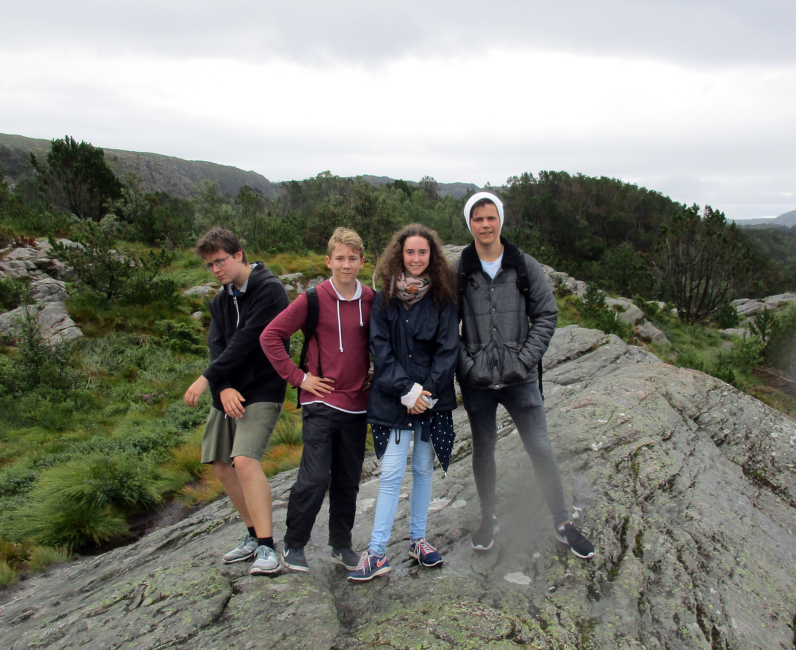
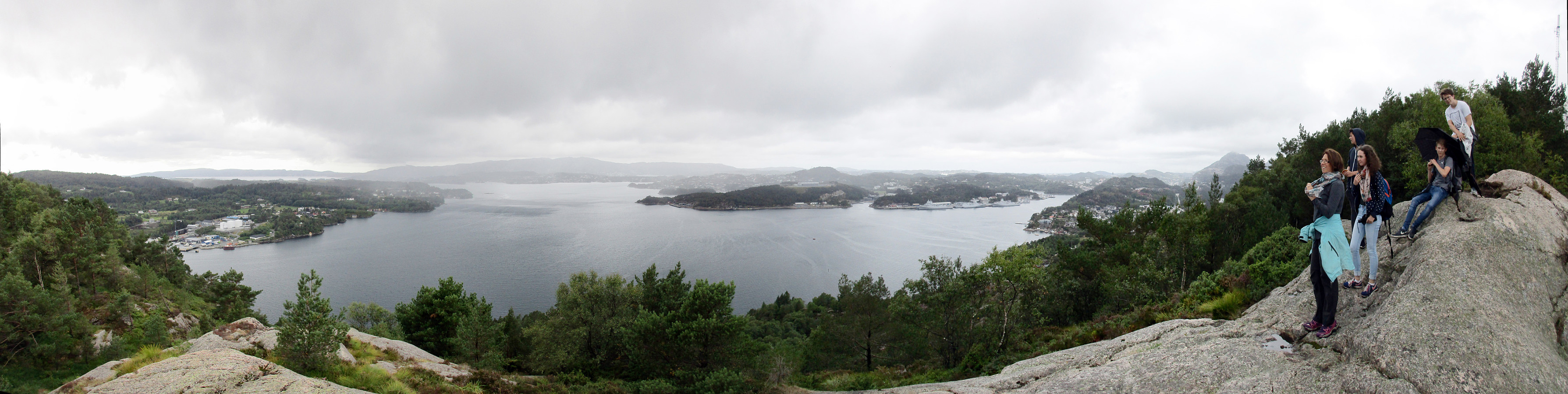
Slettegga and Nobbane
- Datum:
- 11.08.2018
- Tourcharakter:
- Bergtour
- Tourlänge:
- 3:00h
- Entfernung:
- 8,6km
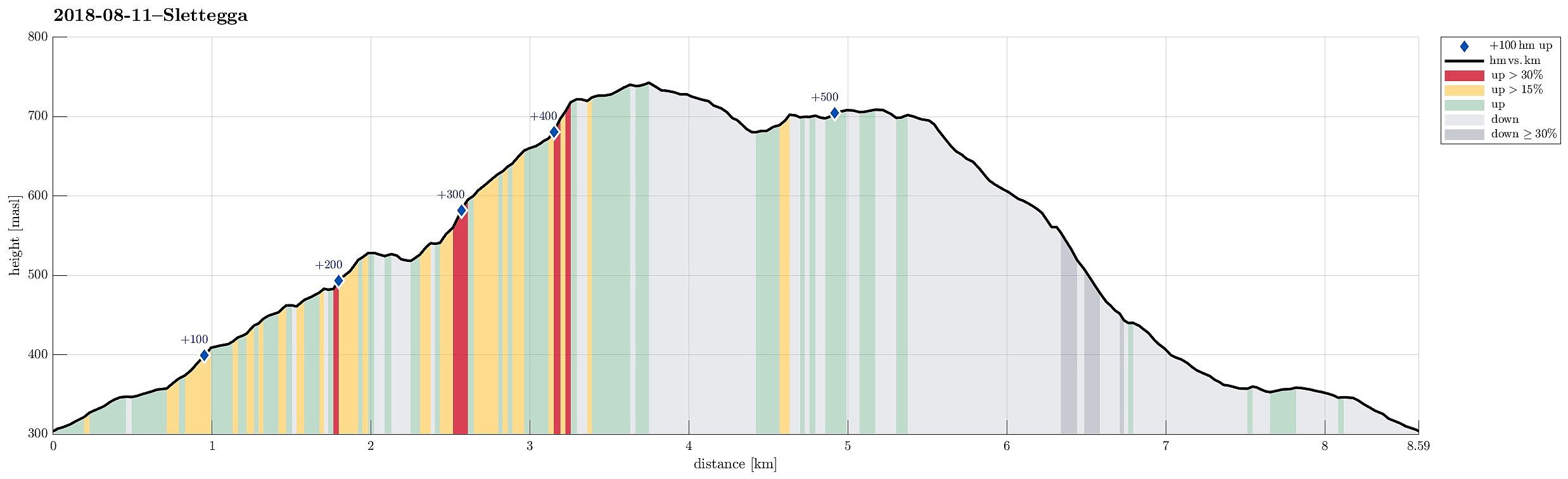 We parked at the Bontveit saddle (where the street crosses over to Hausdalen). From there, we first followed a gravel road that leads northwards. At about 360mosl, we continued along the road, which leads relatively steeply up to Langemyrskaret on the left. Once up there, we continued along the road first, before then following a path, which leads up to Rambjørgvatnet. From there, we started our real ascent to Slettegga, going in northeastern direction. Getting higher, we enjoyed some dramatically looking views into the direction of Arna (the weather was not all sunny). From the top of Slettegga, we first continued along a path, leading into the direction of Austefjellet. Soon after, however, we left the path to cross over to Nobbane, right next to Slettegga and a little lower in altitude. >>>
Up Stoltzekleiven and back via Fløyen
- Datum:
- 06.08.2018
- Tourcharakter:
- Bergtour
- Tourlänge:
- 2:30h
- Entfernung:
- 8,5km
 We took the bus to Sandviken and ascended through some (very) small roads up to Fjellveien in order to get to the start of Stoltzekleiven. A little bit of rain helped to cool us down, while ascending to Sandviksfløyen. From Sandvikspilen it is always a nice view over Bergen! When continuing from there, we could not resist a short dive into Storevatnet, before proceeding towards Fløyen. We took Tippetue (via Vindeggen) down to Bergen, before catching a bus in Olav Kyrres gate. Always a challenge to "run" up Stoltzekleiven as fast as possible! :-)
Selected photos are available as Google photo album .
See also the related FB-page Hiking around Bergen, Norway .
The hiking portal UT.no describes a similar hike .
We took the bus to Sandviken and ascended through some (very) small roads up to Fjellveien in order to get to the start of Stoltzekleiven. A little bit of rain helped to cool us down, while ascending to Sandviksfløyen. From Sandvikspilen it is always a nice view over Bergen! When continuing from there, we could not resist a short dive into Storevatnet, before proceeding towards Fløyen. We took Tippetue (via Vindeggen) down to Bergen, before catching a bus in Olav Kyrres gate. Always a challenge to "run" up Stoltzekleiven as fast as possible! :-)
Selected photos are available as Google photo album .
See also the related FB-page Hiking around Bergen, Norway .
The hiking portal UT.no describes a similar hike .
After-flight hike to Knappen
- Datum:
- 05.08.2018
- Tourcharakter:
- Bergtour
- Tourlänge:
- 2:00h
- Entfernung:
- 4,8km
 To stretch our legs a little bit, we decided to make a quick hike over Knappen, ignoring the fact that it rained (more or less). We started from Varden, went first towards Gjeddevatnet, before we went down to Bjørgeveien and from there further to Sandeidbrotet. From there, we continued via a nice path, leading first up to Eldtona, before from there connecting to Såta, the highest point in Knappen (not very high, after all). After enjoying a bit of a view of Grimstadfjorden, we descended to the southern end of Knappetjørna. Before returning back to Varden via Vassteigen, we dived for a short swim into Knappetjørna. All in all, even though the weather was suboptimal, this was a refreshing excursion at the end of the day.
See also the related FB-page Hiking around Bergen, Norway .
Petter Bjørstad has a useful page about Knappen .
To stretch our legs a little bit, we decided to make a quick hike over Knappen, ignoring the fact that it rained (more or less). We started from Varden, went first towards Gjeddevatnet, before we went down to Bjørgeveien and from there further to Sandeidbrotet. From there, we continued via a nice path, leading first up to Eldtona, before from there connecting to Såta, the highest point in Knappen (not very high, after all). After enjoying a bit of a view of Grimstadfjorden, we descended to the southern end of Knappetjørna. Before returning back to Varden via Vassteigen, we dived for a short swim into Knappetjørna. All in all, even though the weather was suboptimal, this was a refreshing excursion at the end of the day.
See also the related FB-page Hiking around Bergen, Norway .
Petter Bjørstad has a useful page about Knappen .
Exploring Turøyna
- Datum:
- 11.05.2018
- Tourcharakter:
- Bergtour
- Tourlänge:
- 3:00h
- Entfernung:
- 3,3km
 It was time to get out to Turøyna and explore the rather wild nature there! We started from the street to the small settlement on Turøyna and headed towards the large cairn, Turøyvarden, on the largest top of the island. From there, we continued northwards (and without any path) to reach Svartanova via Tuskeluren. From there, to get further northwest to Laksneset, we had to find a way to cross over a rather deep trough. Starting relatively low on Svartanova and searching for a proper place "on half height", walking in southwestern direction, proved to be the right approach and after only a few steps, we were able to cross over. Then it was straight forward to get to Laksneset and enjoy some nice views from there. Continuing our hike around the island, we then followed the >>>
Short hike into Kanadaskogen
- Datum:
- 05.05.2018
- Tourcharakter:
- Bergtour
- Tourlänge:
- 1:00h
- Entfernung:
- 4,8km
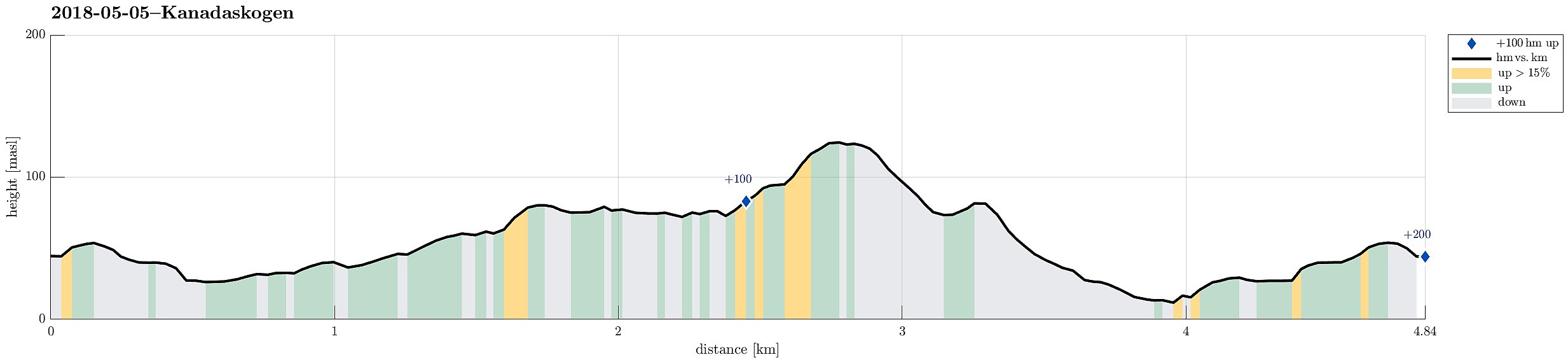 Starting from Varden in the south of Fyllingsdalen, this was "just" a short and quick hike into Kanadaskogen and around Stora Krokatjørna.
See also the related FB-page Hiking around Bergen, Norway .
Starting from Varden in the south of Fyllingsdalen, this was "just" a short and quick hike into Kanadaskogen and around Stora Krokatjørna.
See also the related FB-page Hiking around Bergen, Norway .
Short excursion into Kanadaskogen (from Fyllingsdalen)
- Datum:
- 28.02.2018
- Tourcharakter:
- Bergtour
- Tourlänge:
- 1:00h
- Entfernung:
- 2,2km
 Quick winter excursion into Kanadaskogen from Fyllingsdalen. Since the weather was beautiful and the snow invited for an excursion (and there was a bit of time), I used the opportunity to do a quick excursion into the vicinity of Nipetjørna. Up and down in short time, but greatly enjoyed! :-)
Selected photos are available as Google photo album .
See also the related FB-page Hiking around Bergen, Norway .
Quick winter excursion into Kanadaskogen from Fyllingsdalen. Since the weather was beautiful and the snow invited for an excursion (and there was a bit of time), I used the opportunity to do a quick excursion into the vicinity of Nipetjørna. Up and down in short time, but greatly enjoyed! :-)
Selected photos are available as Google photo album .
See also the related FB-page Hiking around Bergen, Norway .
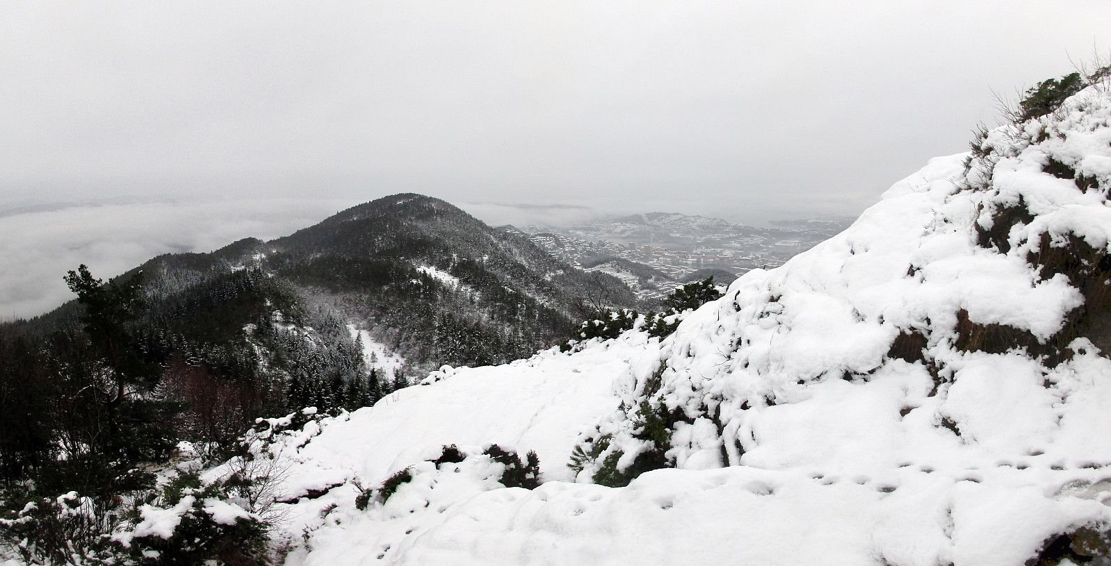
Snow-covered Liatårnet (via an unusual route)
- Datum:
- 25.02.2018
- Tourcharakter:
- Bergtour
- Tourlänge:
- 2:00h
- Entfernung:
- 9,2km
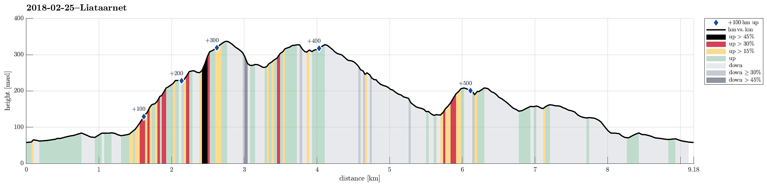 Very nice hike over snow-covered Liatårnet! We started from the west, followed the road (towards the shooting range), before we then entered one of the main hiking paths to Liatårnet (the main route up from the west). But instead of following this path all the way up, we took a turn to the right (southeast) shortly before reaching the main west-face of Liatårnet (at about 200mosl) and connected to another, not so major path, which leads up to Liatårnet from the south. We then connected to Pyttane, walking through a lovely winter landscape, passing by Tårnavatnet. Instead of then following the main road up/down Pyttane, we continued "along the ridge towards the north" (without a path). One has to look a little, where to go, but it's quite possible (especially with enough >>>
Eikelifjellet
- Datum:
- 05.01.2018
- Tourcharakter:
- Bergtour
- Tourlänge:
- 2:00h
- Entfernung:
- 2,5km
 We started from the parking place at the end of Spelhaugen (near the Kindergarden) and took the clearly less used path into northern direction (a bit to the right from the main track up to Tennebekktjørna, also called Mørkebotn). After a short while, the hiking path then leaves the valley towards the right and (steeply) upwards. Before getting to the wet flat spot there, we first explored a little top south of it (mostly to check out the view over Spelhaugen). We then turned around, again into northern direction, got down to the wet flat, crossed it, and started our ascent to Eikelifjellet (this all isn't much of a hike, but it's very nice to go there, not at the least because Eikelifellet really is very steep at this side and one follows a little path up right next to impressive cliff >>>
Løvstakken from Fjøsanger
- Datum:
- 26.12.2017
- Tourcharakter:
- Bergtour
- Tourlänge:
- 2:30h
- Entfernung:
- 5,9km
 We parked near the supermarket at Fjøsanger and walked first a bit up towards the farm Fjøsanger. Before getting there, we connected to a gravel path that runs mostly parallel to the mountain and walked along this one until the forest starts to open up on the left side. At the very edge of the forest, another path then continues steeply upwards and we used this to get "to the next level" (the still relatively new path which maybe later will be connected with the new Løvstien all around Løvstakken's eastern side). We then walked this path to its current end (there is a little hut for having a break). From there, we then continued through the forest, again, getting up to Mindebakken (a little hill, northeast of Gullsteinen). Since Mindebakken is comparably steep on its western >>>
Sauafjellet
- Datum:
- 16.12.2017
- Tourcharakter:
- Bergtour
- Tourlänge:
- 2:00h
- Entfernung:
- 4,5km
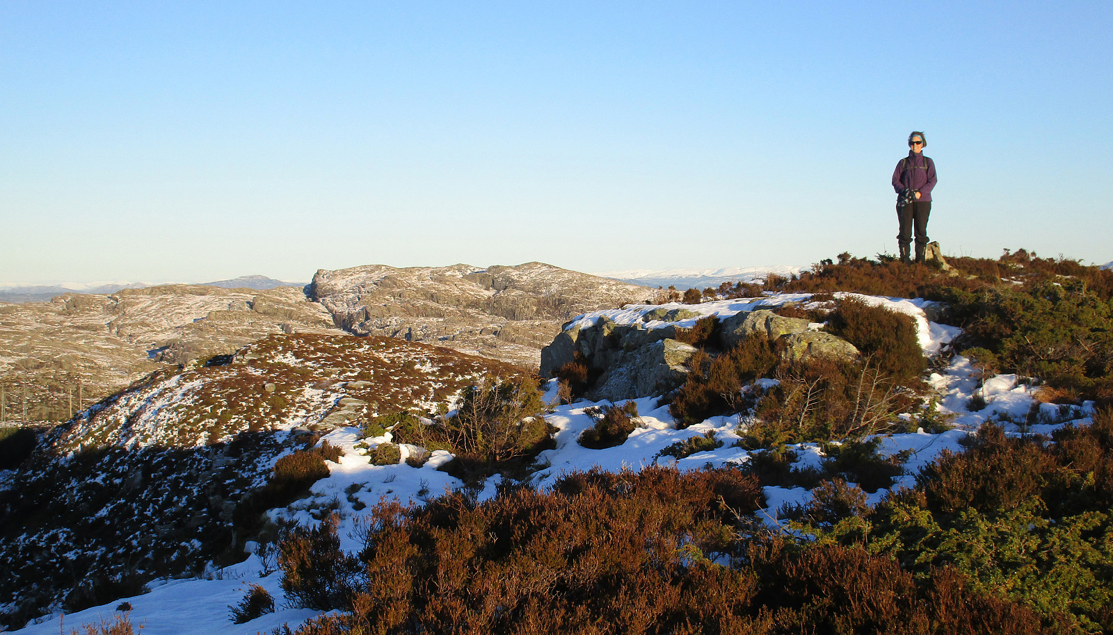 We took the car to Sotra and there to Fjæreide (near Knappskog). We parked near the place where seemingly also the bus turns around (more or less in the middle between Fjæreidpollen in the NE and Fjæreidvatnet in the SW). We then walked first for a few meters down the road which leads down to the water (Fjæreidpollen/Smalneset), before then turning left (following a sign from Kyststien). Within short we were in the snow and soon after we departed from the path towards Spjeldsfjellet (our plan was to get up Sauafjellet first). After quickly ascending to Fagrevollen, we connected to a ridge, which leads up to Sauafjellet in western direction. At Sauafjellet, we enjoyed some great views towards the Atlantic! We then decided to head towards Spjeldsfjellet, even though it was clear that >>>
