Archiv - Nach Datum
Archiv - Nach Aktivität
-
Andere Tour (1)
- Kayaking (1)
-
Andere Wintertour (4)
- Schneeschuhtour (4)
-
Fahrradtour (137)
- Fahrradtour Straße (9)
- Fahrradtour gemischt (51)
-
Fußtour (740)
- Bergtour (363)
- Jogging (18)
- Spaziergang (89)
- Wanderung (270)
-
Skitour (4)
- Tourenskilauf (4)
Archiv - Nach Geografie
Peakbookfreunde


Gesammelte Listen
-
Bergen ≥ 50m pf. og ≥ 100 m.o.h.
(87/89)
 97%
97% -
Most dominating tops of the Bergen peninsula
(68/75)
90%
-
Utvalgte topper og turmål i Bergen
(316/350)
90%
-
Alle topper i Bergen
(357/398)
89%
-
Opptur Bergen
(100/113)
88%
-
De syv fjell rundt Bergen
(6/7)
85%
-
Sund ≥ 50m pf.
(14/18)
77%
-
Os ≥ 50m pf.
(25/34)
73%
-
Søyler (fastmerker) i Bergen
(68/100)
68%
-
Fjell ≥ 50m pf.
(21/32)
65%

Løvstakken from/to Bergen
- Datum:
- 25.12.2025
- Tourcharakter:
- Wanderung
- Tourlänge:
- 1:30h
- Entfernung:
- 6,7km
 Even though it was a bit late, already, we still wished to make a quick round somewhere near. Doing Løvstakken from the Bergen-side seemed just right (and so it was). We used the gravel road that starts from Løvstien just above Solheimslien to get up. On Løvstakken, we met an unexpected sight: most of one of the two masts was missing from its top -- what's happening? :-) To get back down, we chose to cross over Ravnefjellet and then use Løvstien to get back around to the Bergen-side. Our timing was just right to return before it got all dark.
Selected photos are available as Google photo album .
See also the related FB-page Hiking around Bergen, Norway .
Web page WestCoastPeaks.com provides useful information about Løvstakken .
Even though it was a bit late, already, we still wished to make a quick round somewhere near. Doing Løvstakken from the Bergen-side seemed just right (and so it was). We used the gravel road that starts from Løvstien just above Solheimslien to get up. On Løvstakken, we met an unexpected sight: most of one of the two masts was missing from its top -- what's happening? :-) To get back down, we chose to cross over Ravnefjellet and then use Løvstien to get back around to the Bergen-side. Our timing was just right to return before it got all dark.
Selected photos are available as Google photo album .
See also the related FB-page Hiking around Bergen, Norway .
Web page WestCoastPeaks.com provides useful information about Løvstakken .
Lyderhorn via Skarpafjellet
- Datum:
- 06.12.2025
- Tourcharakter:
- Wanderung
- Tourlänge:
- 1:30h
- Entfernung:
- 4,5km
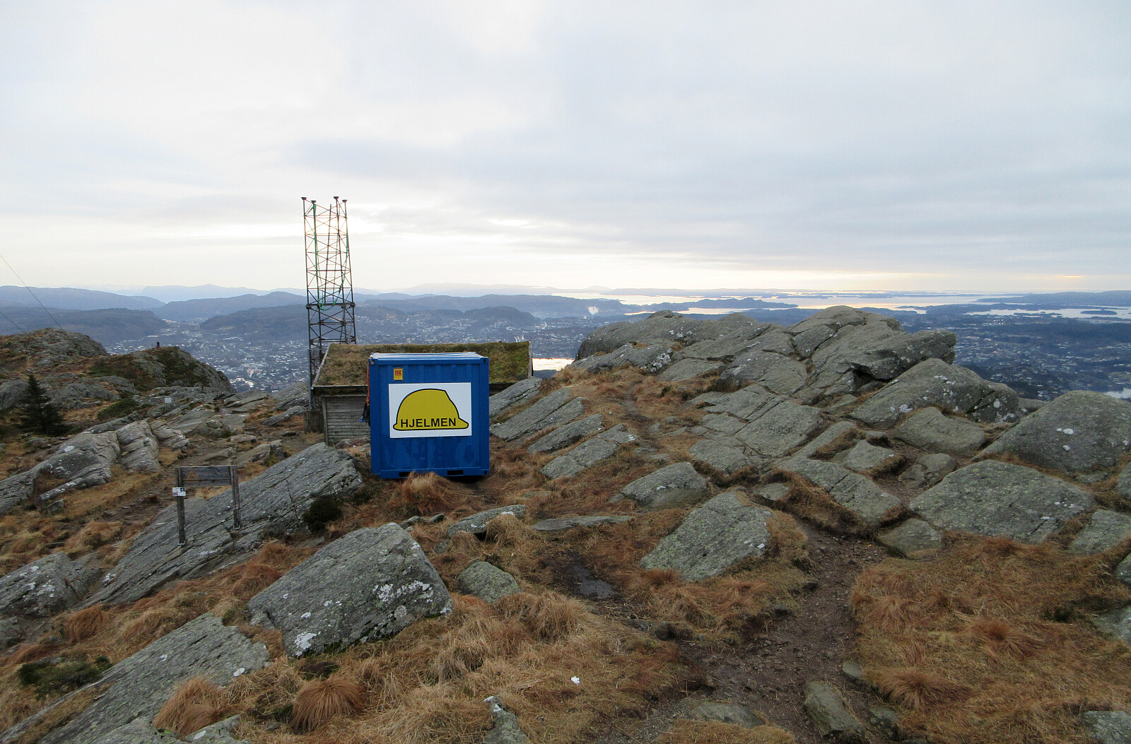
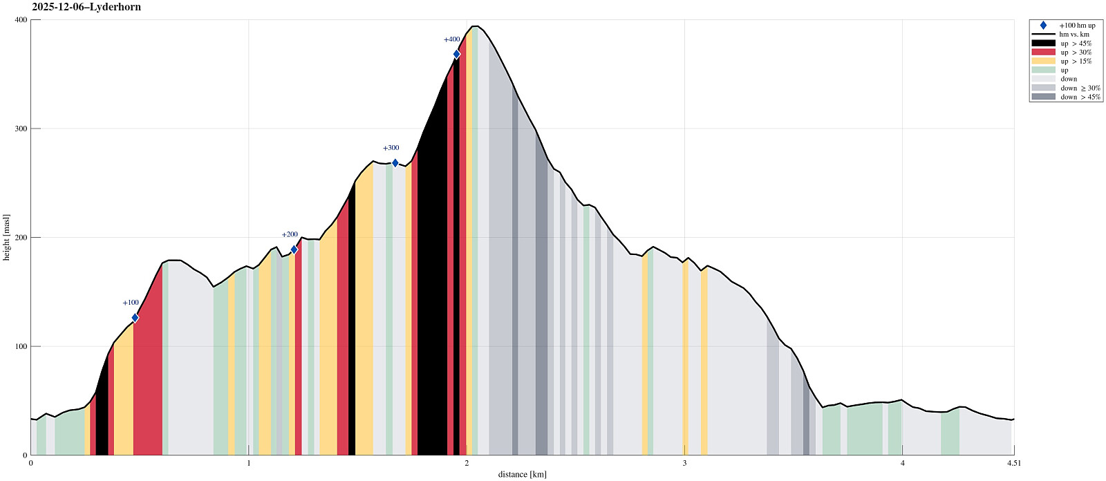 Aiming at some nice but not too long weekend hike, we decided to visit Lyderhorn (again). The plan was to ascend via Skarpafjellet in the south of Lyderhorn. We parked at Bjørndalen and tried an as direct as possible (off-trail) ascent to Skarpafjellet, first. As soon as we had left road Sildaberget (right next to Lyderhornsveien), we immediately found ourselves (not unexpectedly, though) in rather steep terrain, which required a bit of hand help to make it up between the rocks. As soon as we were up to about 90masl, however, progress became easier and rather straight-forward -- all the way to the top of Skarpafjellet. This southern flank of Skarpafjellet is actually very nice, offering some nice views over Bjørndalen and Bjørndalspollen. From Skarpafjellet, we then followed the main >>>
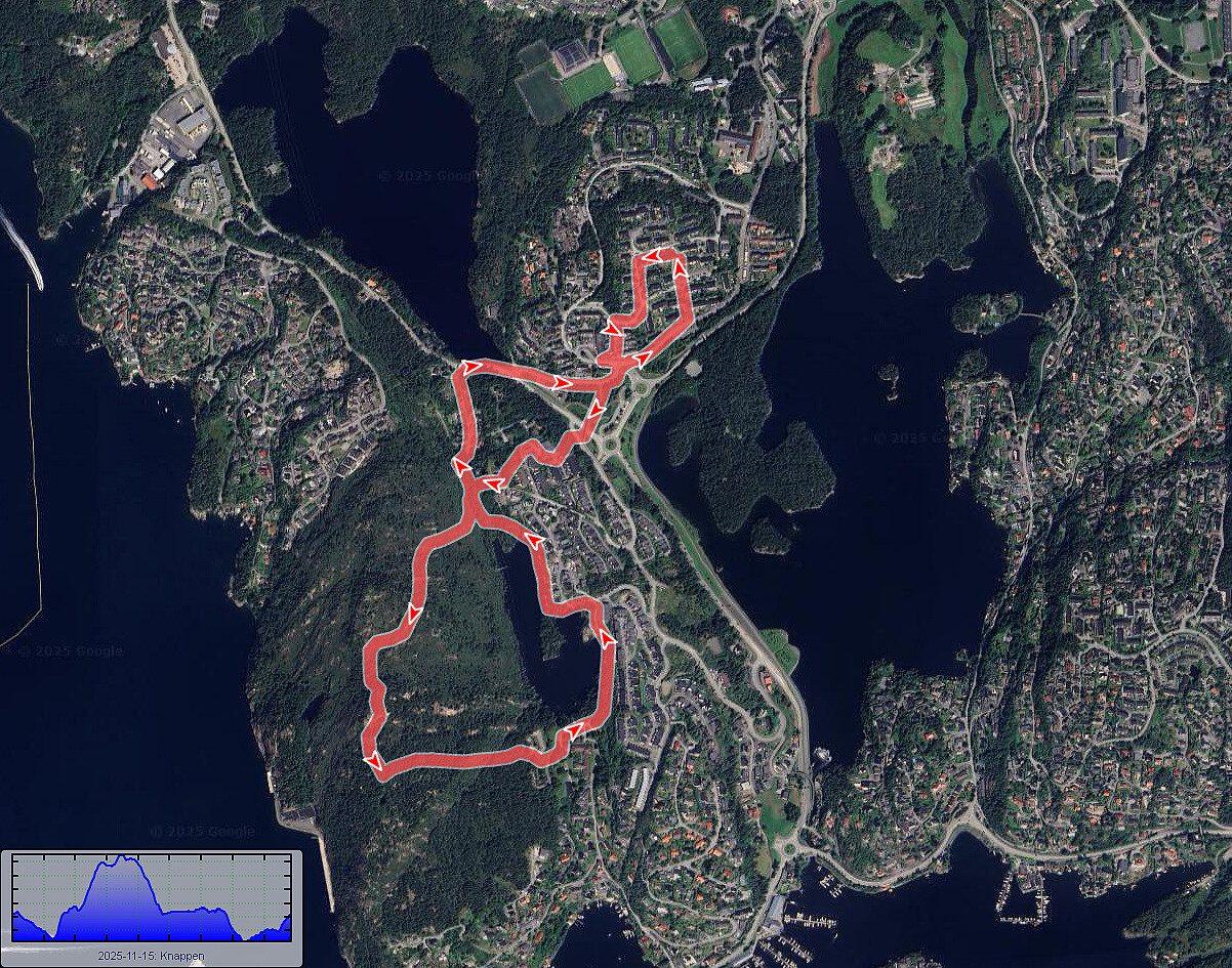
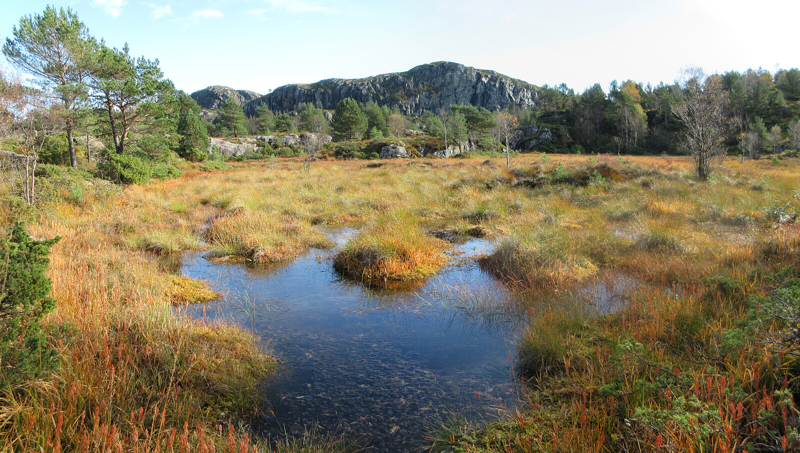
A dragon on Knappen?
- Datum:
- 29.11.2025
- Tourcharakter:
- Wanderung
- Tourlänge:
- 1:30h
- Entfernung:
- 5,5km
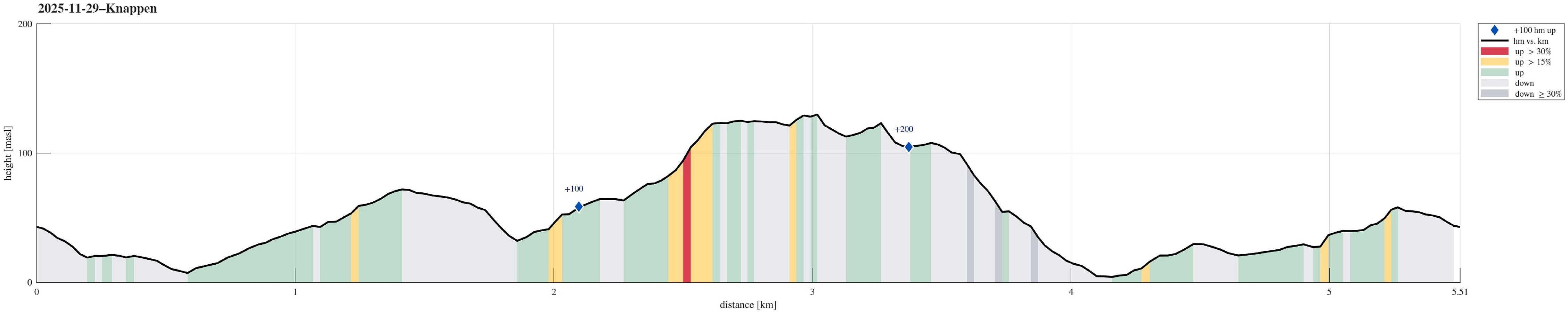 When the winter days are short, it's sometimes no more than "just" making a quick (but still nice!) round across Knappen! :-)
Selected photos are available as Google photo album .
See also the related FB-page Hiking around Bergen, Norway .
Petter Bjørstad has a useful page about Knappen .
Web page UT.no from the Norwegian Trekking Association recommends another hike to Knappen .
When the winter days are short, it's sometimes no more than "just" making a quick (but still nice!) round across Knappen! :-)
Selected photos are available as Google photo album .
See also the related FB-page Hiking around Bergen, Norway .
Petter Bjørstad has a useful page about Knappen .
Web page UT.no from the Norwegian Trekking Association recommends another hike to Knappen .
Kubrekka from/to Sandven
- Datum:
- 23.11.2025
- Tourcharakter:
- Wanderung
- Tourlänge:
- 1:30h
- Entfernung:
- 3,9km
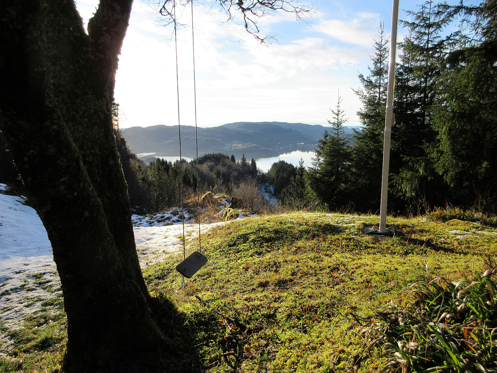 We had time for a relatively short walk but still were interested in exploring opportunities to do something new. Expecting chances for some low-standing November sun from the southwest, we thought that hiking up to Kubrekka from Sandven right next to Kalandsvatnet could be a reasonable option (yes, when "digging deeper", we read in Harald's trip report that the top had no views and is of no interest to normal hikers; but then: are we normal hikers? :-)). The main idea was to go up via Stemmedalen, then cross over Kubrekka from the northwest to the southeast, before then walking down Høgerinden in parallel to Tjørnadalen to get back to Sandven. When aiming for Stemmedalen from Osvegen, however, we faced a sign informing us that someone would not like us to proceed further towards Stemmedalen along >>>
Quick round on Knappen
- Datum:
- 15.11.2025
- Tourcharakter:
- Wanderung
- Tourlänge:
- 1:00h
- Entfernung:
- 4,4km
 When time is limited, but you still wish to stretch your legs a little in some fresh air, then Knappen is always there for you! :-)
See also the related FB-page Hiking around Bergen, Norway .
Petter Bjørstad has a useful page about Knappen .
Web page UT.no from the Norwegian Trekking Association recommends another hike to Knappen .
When time is limited, but you still wish to stretch your legs a little in some fresh air, then Knappen is always there for you! :-)
See also the related FB-page Hiking around Bergen, Norway .
Petter Bjørstad has a useful page about Knappen .
Web page UT.no from the Norwegian Trekking Association recommends another hike to Knappen .
Liatårnet from Fjellavegen via Fjellasåta
- Datum:
- 12.10.2025
- Tourcharakter:
- Wanderung
- Tourlänge:
- 4:00h
- Entfernung:
- 7,4km
 We parked south of Fjell along Søre Fjellavegen and started our hike by aiming at Fjellasåta via Rindane. Basically at the saddle, where Søre Fjellavegen starts to descend again towards the south, we found a very basic trail (or something like that), which brought us well up and onto Rindane (towards the east). Even though this trail (or "trail") was not always immediately obvious, we still made it quickly and easily to Fjellasåta (Kannikahaugen). From there, and instead of following the north-south oriented trail across Fjellasåta, we proceeded further eastwards (towards the southern end of Gyravatnet). When down at Festningsvegen, we did not have to search long before we found a little opening in the thick valley forest. This opening connected to a simple "trail" >>>
Lyderhorn from Kjøkkelvikveien
- Datum:
- 05.10.2025
- Tourcharakter:
- Wanderung
- Tourlänge:
- 2:00h
- Entfernung:
- 4,7km
 We parked close to the Kjøkkelvikveien-Nedbergeveien junction and first walked a bit along Kjøkkelvikveien to find a good place for starting our ascent towards Stemmebakkane and Høgenuten. Opposite to Fæsterveien, we then found a narrow access road, leading up to the house with number 105. After the second hairpin curve up the rather steep mountain side, we then followed a simple trail into the forest (and further upwards). Even though there's no trail to be seen on Norgeskart for this part, one still can find simple hiking trails "all the way up" to Stemmebakkane and Høgenuten. From up there, one also then can enjoy some nice views. A bit south of Høgenuten, one then joins the main trail to Lyderhorn. After making it "all the way up" to Lyderhorn (not so much >>>
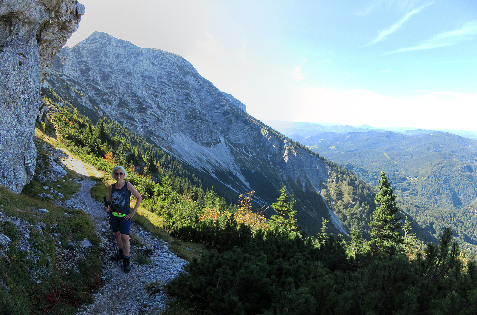
Hochstaff & Reisalpe from Ebenwaldhöhe
- Datum:
- 27.09.2025
- Tourcharakter:
- Wanderung
- Tourlänge:
- 4:00h
- Entfernung:
- 9,7km
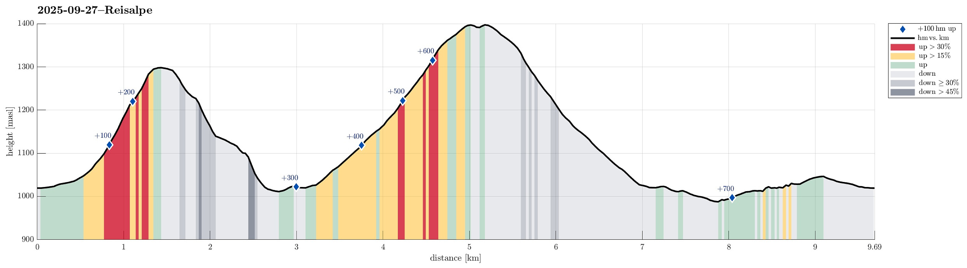 Expecting some nice weather on this Saturday, we aimed at a nice hike not too far from Vienna. After comparing a few opportunities, we ended up with driving to Ebenwaldhöhe in the west of Kleinzell and hiking from there to Reisalpe, also including an ascent to Hochstaff "on the way". For some 400 meters, we first followed a simple road, mostly in southern direction, across Ebenwaldhöhe, before then deviating from the main track (which leads around Hochstaff on its northwestern side) to include an ascent to Hochstaff, also. This route is not exactly well marked and one better knows where to go; despite of this detail, however, it's still all on proper trails to get up to Hochstaff from Ebenwaldhöhe (the ascent to Hochstaff is quite steep, but still nicely within "regular >>>
Ötscher via Rauher Kamm from Lackenhof
- Datum:
- 21.09.2025
- Tourcharakter:
- Wanderung
- Tourlänge:
- 6:00h
- Entfernung:
- 15,9km
 After spending the night involuntarily at an airport hotel in Amsterdam, we got to Vienna early on this Sunday, expecting a nice day. We thus rushed to get into the mountains, driving to Lackenhof in the southwest of Vienna. Our plan was to make a nice hiking round up and down Ötscher, using its northeastern ridge (Rauher Kamm) as the ascent route, while then descending via the Ötscherschutzhaus in the southwest of the mountain. Once in Lackenhof, we aimed at the large parking lot in Weitental to leave the car behind -- just to find that it was completely full with cars (while the combination of Sunday with nice weather and our relatively late arrival could have let us anticipate this situation, we had not). Luckily, one parking place got freed up only minutes after our arrival, letting >>>
Lundåsane from Hausdalen
- Datum:
- 14.09.2025
- Tourcharakter:
- Wanderung
- Tourlänge:
- 3:00h
- Entfernung:
- 5,9km
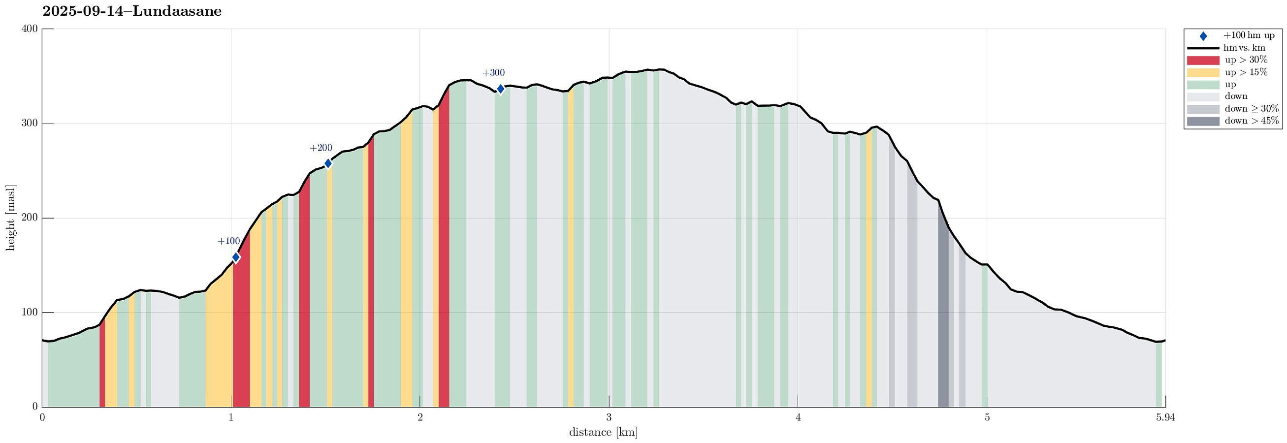 We wished to explore the Hausdalen-side of Lundåsane and thus drove to Hausdalen, where we parked a bit south of Håland. From there, we first walked up a gravel road that extends parallel to Hålandsbekken. About half way up, I decided that I wished to explore Storerinden, in the east of Slokadalen, also. Stepping up to this hill was straight-forward, while not on a trail, though. From Storerinden, while not really a prominent "peak", I still got a nice view towards Hausdalshorgi (it's always nice to see Hausdalshorgi!). I then continued across the ridge to re-connect with the gravel road near the T-junction, where one leg of the gravel road extends a bit further up to Plasset. Instead of following the gravel road any further, though, I used a trail (maybe more a former trail) >>>
