Archive - Date
Archive - Activity
-
Bike trip (123)
- Bike trip - mixed (41)
- Bike trip - road (5)
-
Other trip (1)
- Kayaking (1)
-
Other winter trip (4)
- Snowshoe trip (4)
- Ski trip (4)
- Trip by foot (736)
Archive - Geography
Peakbook-Friends


Collected lists
-
Bergen ≥ 50m pf. og ≥ 100 m.o.h.
(87/89)
 97%
97% -
Most dominating tops of the Bergen peninsula
(68/75)
90%
-
Utvalgte topper og turmål i Bergen
(313/347)
90%
-
Alle topper i Bergen
(356/398)
89%
-
Opptur Bergen
(100/113)
88%
-
De syv fjell rundt Bergen
(6/7)
85%
-
Sund ≥ 50m pf.
(14/18)
77%
-
Os ≥ 50m pf.
(25/34)
73%
-
Søyler (fastmerker) i Bergen
(68/100)
68%
-
Fjell ≥ 50m pf.
(21/32)
65%

Breheimen, day 1: from Skjolden via Haugsnosi to Fast
- Date:
- 24.07.2019
- Characteristic:
- Hike
- Duration:
- 9:00h
- Distance:
- 18.9km
 After our arrival in Luster the day before , we started our five days hike through Breheimen in Skjolden, Luster, at the very end of Sognefjorden (Lustrafjorden). On the map, we had seen that a trail should lead up to Persli from nearby Notasvaet, about 500m northwest of the bridge over Mørkriselvi in Skjolden, beginning with a forest road and then continuing "diagonally" upwards via Haukhammar to Stakkslettehaugen. The forest road was indeed easy to find, but then the continuation was completely unclear. We tried hard to locate the path through the forest, but could not find any (just very vague indications of someone, maybe a deer, having stepped there every now and then). We thus stepped through the (steep) forest upwards, into the direction of Stakkslettehaugen, without any path and at times proceeding was non-trivial. >>>
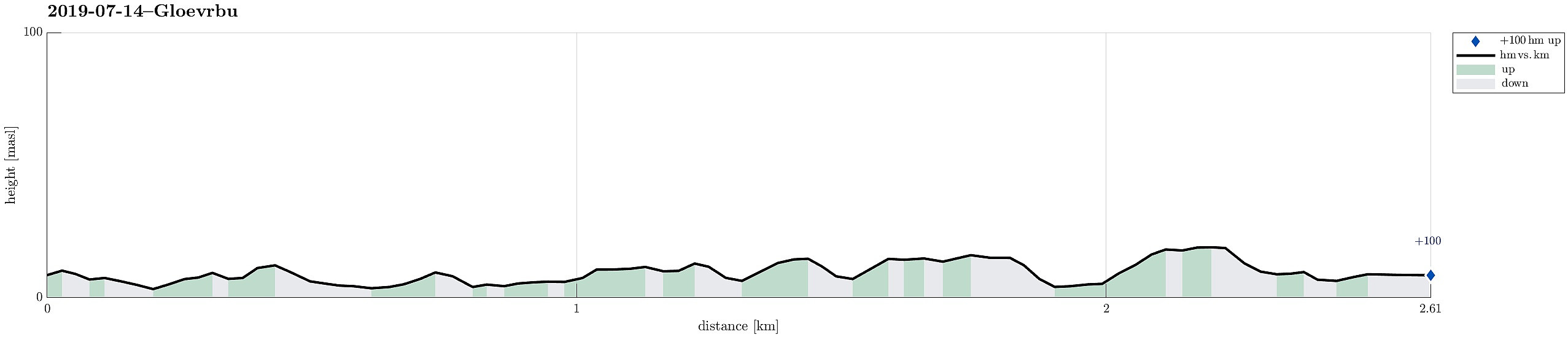
Gløvrebu in Øygarden
- Date:
- 14.07.2019
- Characteristic:
- Hike
- Duration:
- 1:30h
- Distance:
- 2.6km
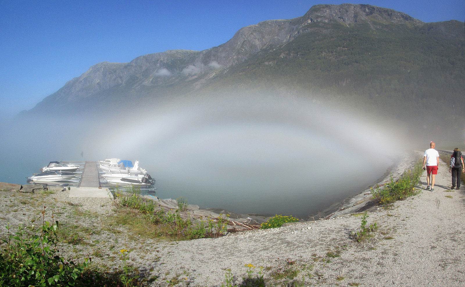
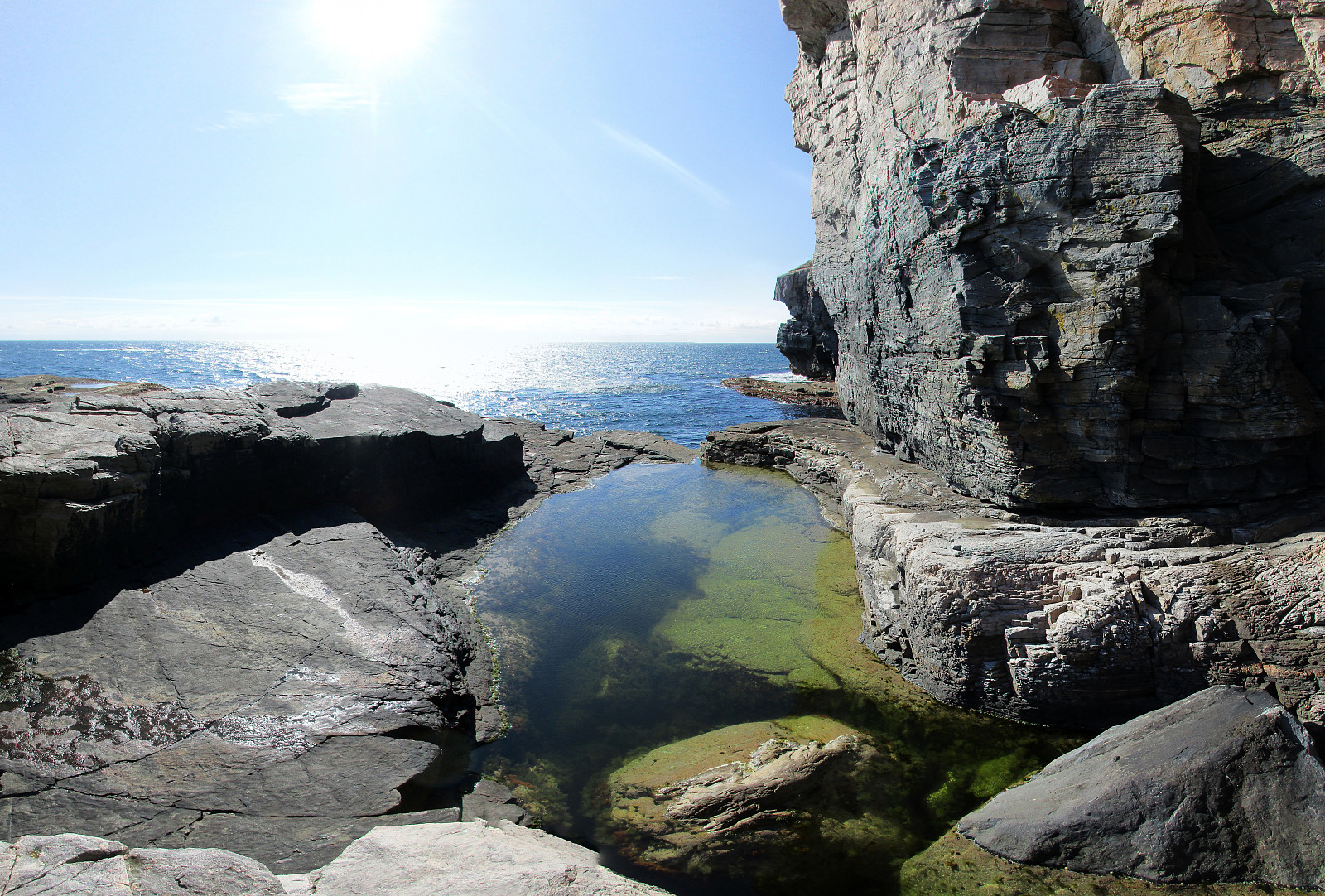
 Driving from Bergen to Sotra, we turned north after Kolltveittunnelen, continuing on road 561 towards Øygarden. Driving almost all the way out (to Hellesøy), we came to Seløyna. While the road is getting really narrow there, one cannot overlook Hjelme Kyrkje, when passing by. Only meters later, right next to the rather big graveyard, we parked the car and started to follow a nice trail into the direction of Stakksvika. Close to the sea, the trail splits with the southern route being a bit more direct to Gløvrebu. Still, the slightly longer route (towards Stakksvika first) is very nice, offering views to and beyond Bobbeskjeret. From there, it's then towards the south and to Gløvrebu. While the whole area there is nice to see, the main sight is a major cut through the rock near the >>>
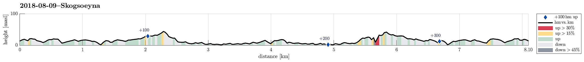
Skogsøyna on a nice summer Sunday!
- Date:
- 14.07.2019
- Characteristic:
- Hike
- Duration:
- 3:00h
- Distance:
- 5.5km
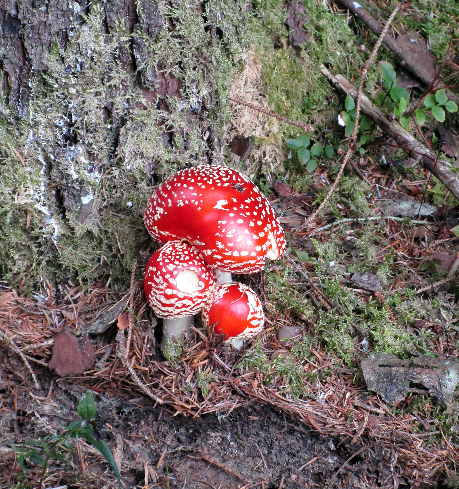
 Since we were in Øygarden already, we decided to also pay a visit to Skogsøyna, which always is worth a little hike! To get there, we found road 228 towards Herdleværet. On Skogsøyna, just before crossing the bridge to Herdleværet, we parked the car and started to hike towards the west, following the northern rim of Skogsøyna. We were again positively impressed about work that was done recently to further improve this trail, making it easier to avoid wet and/or muddy shoes. Nice! :-) At the outer tip of Skogsøyna, we reached our goal for this day, Skoysøytua (some 50m above sea level and with nice views over the open Atlantic!). We explored the cliffs and watched the energetic ocean rumble against the rocks of Skogsøytua. We also rounded the cliffs in order to get further down >>>
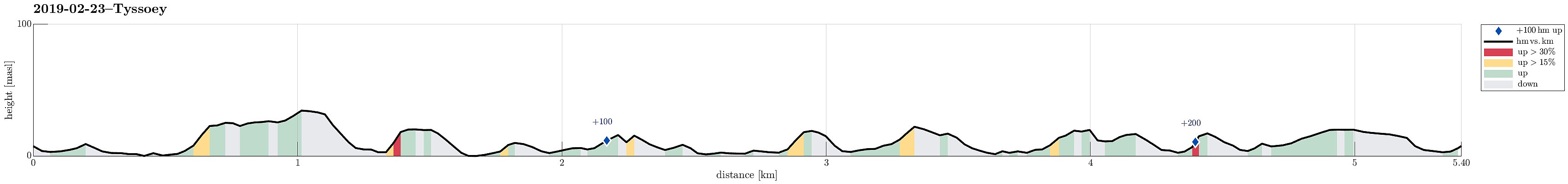
Around Tyssøy on a windy day
- Date:
- 23.02.2019
- Characteristic:
- Hike
- Duration:
- 2:00h
- Distance:
- 5.4km
 We took the car to Tyssøy (via Mathopen, then through the tunnel under Vatlestraumen, and then across Bjorøyna) and parked at Støene, where also the bus turns around. Our plan was to walk around the island and thus we left the "main road" already in the first turn (towards the southeast). We came by quite a number of goats before visiting Storeklubben first. From there, we first went a few steps back in order to reconnect with the main trail that leads southwards along the shore of Tyssøy (but a bit higher up in the terrain). We followed the well-marked path southwards until we came near to Slettevikklubben. There, instead of further following the trail, which leads "back" towards the central trail across the island, we improvised towards Børvika. This wasn't >>>
Algrøyna, Barmaneset, Langtrotten -- wow!
- Date:
- 23.09.2018
- Characteristic:
- Hike
- Duration:
- 3:30h
- Distance:
- 6.4km
 We parked the cars just before entering the main village on Algrøyna and started to hike from there. It had just poored down substantially, but as we started hiking the weather improved and soon we saw some sun, also! :-) We first followed the "main road", Nordre Øyavegen, in a longer swing to the right/north, before turning left, continuing on Kongvikvegen. Before the end of this road and about where Kungvika has its western-most point, we left the road, walking around a farm house right next to the road, in order to connect to the southern side of Kungvika (and eventually to Barmaneset). Once on the "middle" peninsula of Algrøyna, we followed a path with blue marks towards the west. This path leads out on Barmaneset and to Krabbakeila at its western end. Enjoying >>>
Hiking the southern part of Strøno
- Date:
- 08.09.2018
- Characteristic:
- Hike
- Duration:
- 2:30h
- Distance:
- 6.1km
 There was not really time for a longer hike and also it was expected that some rather heavy rain may come in the early evening. Therefore, we decided to do something smaller, i.e., a hike over Strøno south of Bergen (and west of Osøyro). We passed Fanafjellet with our car and turned right (westwards) at the military camp at Ulven. Following the street, we soon crossed over the bridge at Hillershavn to Strøno. Once on Strøno, we followed the southern street to Sørstrøno. From there, we started hiking, first following a major gravel road which passes by Strønevågen and Selvågspollen (in their northwest).
Our first goal was Husfjellet, a little hill that stands a bit for its own in the very south of Strøno. We first continued on the gravel road, making a half-circle around the hill >>>
There was not really time for a longer hike and also it was expected that some rather heavy rain may come in the early evening. Therefore, we decided to do something smaller, i.e., a hike over Strøno south of Bergen (and west of Osøyro). We passed Fanafjellet with our car and turned right (westwards) at the military camp at Ulven. Following the street, we soon crossed over the bridge at Hillershavn to Strøno. Once on Strøno, we followed the southern street to Sørstrøno. From there, we started hiking, first following a major gravel road which passes by Strønevågen and Selvågspollen (in their northwest).
Our first goal was Husfjellet, a little hill that stands a bit for its own in the very south of Strøno. We first continued on the gravel road, making a half-circle around the hill >>>
Nice and wild Skogsøyna
- Date:
- 09.08.2018
- Characteristic:
- Hike
- Duration:
- 3:30h
- Distance:
- 8.1km
 We parked our cars near the bridge between Skogsøyna and Herdlevær, where a board also tells the hikers about the island and the paths that one can take. From there, we followed the main path along the northwestern shore of Skogsøyna, heading towards the spectacular southwestern end of the island. After a bit of hiking, we approached Skogsøytua, i.e., the highest point on this trip (about 45mosl). From there, instead of heading back "as usually", we first explored the lower parts of the cliffs at Skogshola. Note that it is critical that you indeed judge the situation correctly in order to avoid any dangerous and unwanted problems with the sea. Should it happen that a wave takes you off the stones, it is likely possible that you will end up in severe troubles (others have >>>
Short hike on Storskora
- Date:
- 11.05.2018
- Characteristic:
- Hike
- Duration:
- 0:30h
- Distance:
- 2.0km
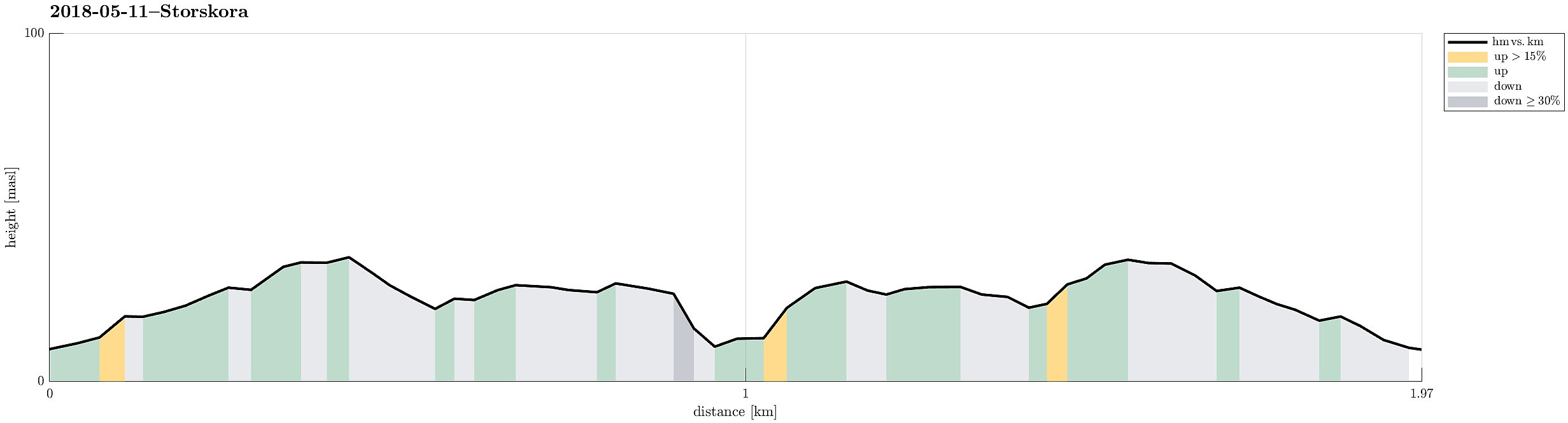 After our hike on Turøyna , we continued with a short hike on Storskora, visiting a little light house at the northwestern end of this little island. Following a nicely marked path from the street, it was straight-forward to reach our target. From there, we basically took the same path back, then.
Selected photos are available as Google photo album .
See also the related FB-page Hiking around Bergen, Norway .
After our hike on Turøyna , we continued with a short hike on Storskora, visiting a little light house at the northwestern end of this little island. Following a nicely marked path from the street, it was straight-forward to reach our target. From there, we basically took the same path back, then.
Selected photos are available as Google photo album .
See also the related FB-page Hiking around Bergen, Norway .
Short hike along the northwestern side of Sælenvatnet
- Date:
- 06.05.2018
- Characteristic:
- Hike
- Duration:
- 0:30h
- Distance:
- 2.3km
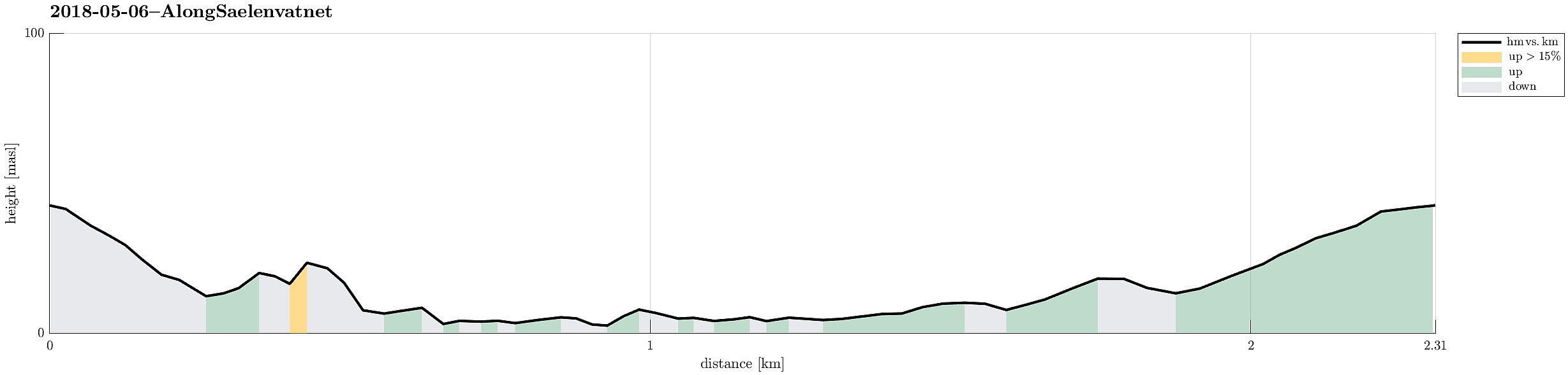 Starting from Varden, this was "only" a short hike along the northwestern side of Sælenvatnet.
Selected photos are available as Google photo album .
See also the related FB-page Hiking around Bergen, Norway .
Starting from Varden, this was "only" a short hike along the northwestern side of Sælenvatnet.
Selected photos are available as Google photo album .
See also the related FB-page Hiking around Bergen, Norway .
Short walk in Kanadaskogen
- Date:
- 02.04.2017
- Characteristic:
- Hike
- Duration:
- 1:00h
- Distance:
- 3.5km
 We simply headed for Kanadaskogen (from Varden) and explored some paths aside of the more regularly used ones. After all, this was just a short walk in order to get some fresh air. How nice to have Kanadaskogen right around the corner! :-)
Selected photos are available as Google photo album .
See also the related FB-page Hiking around Bergen, Norway .
We simply headed for Kanadaskogen (from Varden) and explored some paths aside of the more regularly used ones. After all, this was just a short walk in order to get some fresh air. How nice to have Kanadaskogen right around the corner! :-)
Selected photos are available as Google photo album .
See also the related FB-page Hiking around Bergen, Norway .
