Archiv - Nach Datum
Archiv - Nach Aktivität
-
Andere Tour (1)
- Kayaking (1)
-
Andere Wintertour (4)
- Schneeschuhtour (4)
-
Fahrradtour (137)
- Fahrradtour Straße (9)
- Fahrradtour gemischt (51)
-
Fußtour (740)
- Bergtour (363)
- Jogging (18)
- Spaziergang (89)
- Wanderung (270)
-
Skitour (4)
- Tourenskilauf (4)
Archiv - Nach Geografie
Peakbookfreunde


Gesammelte Listen
-
Bergen ≥ 50m pf. og ≥ 100 m.o.h.
(87/89)
 97%
97% -
Most dominating tops of the Bergen peninsula
(68/75)
90%
-
Utvalgte topper og turmål i Bergen
(316/350)
90%
-
Alle topper i Bergen
(357/398)
89%
-
Opptur Bergen
(100/113)
88%
-
De syv fjell rundt Bergen
(6/7)
85%
-
Sund ≥ 50m pf.
(14/18)
77%
-
Os ≥ 50m pf.
(25/34)
73%
-
Søyler (fastmerker) i Bergen
(68/100)
68%
-
Fjell ≥ 50m pf.
(21/32)
65%

Gjønakvitingen from Gjøn (via Selfjellet)
- Datum:
- 17.08.2025
- Tourcharakter:
- Wanderung
- Tourlänge:
- 8:00h
- Entfernung:
- 13,5km
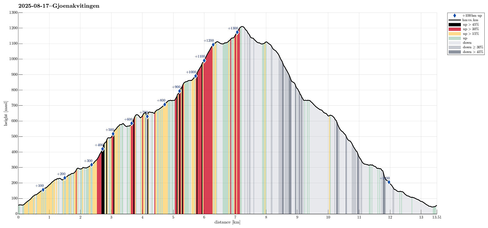 The weather was promising and so we thought this would be a good day to hike up to Gjønakvitingen from Gjøn. From Bergen, we drove towards the East, first along E16, then road #49, before taking road #48 to Eikelandsosen. From there, it was not too far, continuing into eastern direction, before we changed to a narrow road at Holdhus. This way, we drove around the south end of Gjønavatnet in order to get to Gjønavegen, which brought us to Gjøn. At about noon-time, we then started our hike (with enough time on such a nice, long summer Sunday). The one, small "twist", which we had cooked up, when studying the map at home, was to include Selfjellet (via an ascent on the western side of Skarvaelva), before eventually taking the "main trail" down (south of Sauaskorfjellet). >>>
Byrkjefjellet, Iendefjellet, and Skeisheia
- Datum:
- 02.08.2025
- Tourcharakter:
- Wanderung
- Tourlänge:
- 7:00h
- Entfernung:
- 16,5km
 We expected "one last nice day before the rain" and thus aimed at one more nice hike! :-) Without much hesitation, we agreed to make a hike to Iendefjellet, north of Kvamskogen. We took the car from Bergen to Kvamskogen and parked at the southern end of Tryglakleiv, right next to the "main road" across Kvamskogen (road #49). We then started to hike up road Tryglakleiv, aiming at the heights in the southwest of Tryglakleivtjørnane. All of this is easy to find and from "up there" (a bit below 600 masl), the real ascent towards Byrkjefjellet starts (then mostly in northern direction). Following a proper trail, we completed the (partially steep) ascent relatively quickly. It was, however, very hot and we recognized and respected the roughly 600 height meters >>>
Livarden from Haukelandsvatnet
- Datum:
- 27.07.2025
- Tourcharakter:
- Wanderung
- Tourlänge:
- 4:00h
- Entfernung:
- 7,9km
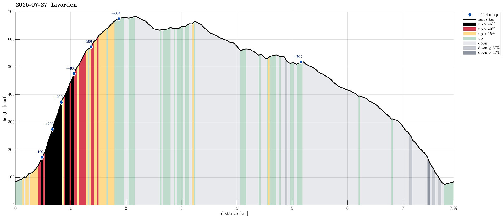 We wished to use (part of) the nice Sunday for a nice hike and chose Livarden, not far from Bergen. Instead of the usual hike (from Totland), we decided to approach it "direttissima" from Haukelandsvatnet. We parked in the southeast of Nygardsvika (langs Unnelandsvegen) and started in easterly direction -- to pass by (and below) Kalvehalsen. For a bit, we followed a (faint) trail, which leads up to a small building south (and above) Kalvehalsen. Instead of following this trail for any longer part, however, we quickly aimed at Stallafossen (there wasn't much to see or hear of this waterfall, though -- probably due to the rather dry perdiod during the past days). The goal was to ascend to a ridge in the south of Stallafossen (the first "big" one on the westside of the >>>
Mt. Miyanoura on Yakushima
- Datum:
- 01.07.2025
- Tourcharakter:
- Wanderung
- Tourlänge:
- 7:30h
- Entfernung:
- 13,6km
 To include a nice hike had been part of our original plans for our visit to Yakushima. Depending on the circumstances, we also had looked at an ascent to Mt. Miyanoura, the hightest top of Yakushima, but wanted to wait until we would be in a better position to understand the weather, our form, etc. After one nice day of chilling on Yakushima, everything looked good and we made an early start to give us enough time for the there-and-back hike (officially 2*8km according to all signs). To make the actual ascent to Mt. Miyanoura possible for us on this day, we first drove up to the Yodogawa Mountain Trail Entrance at some 1370masl. This drive, already, to the high up end of a narrow mountain road, was a nice experience -- with numerous turns and a close-up impression of the surrounding jungle. >>>
Nakadake (Kuju mountains) from Makinoto Pass
- Datum:
- 28.06.2025
- Tourcharakter:
- Wanderung
- Tourlänge:
- 5:00h
- Entfernung:
- 12,2km
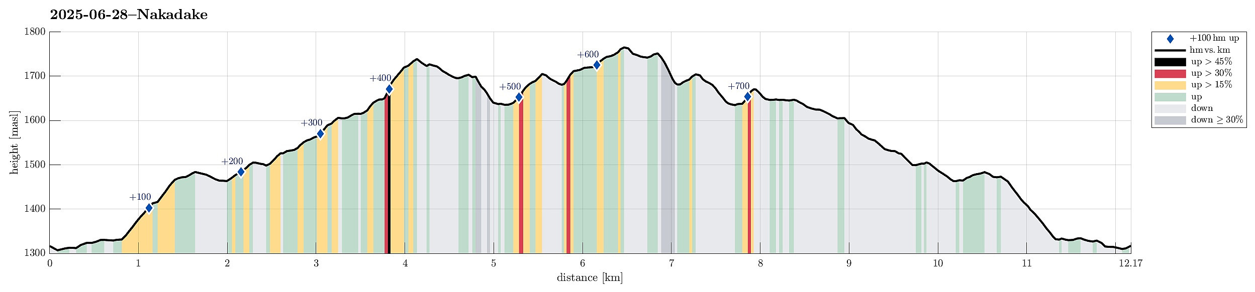 It was one of our goals for our visit to Kyushu to make a nice hike near Mt. Aso and this hike in the Kuju mountains, north of the massive caldera of volcano Aso, seemed very nice from its description. To get started, we drove to the Makinoto Pass in the West of Mt. Nakadake, but found that all parking spots had been taken, already. A bit further down the road, however, we found a place, where we could leave the car. After first walking back to the pass, we then followed the main trail in easterly direction. Gaining height steadily, we came to a place, where it was to Mt. Ogigahana to the right, and to "all other tops" to the left. Just shortly after choosing the latter option, we then followed a side-trail (without any signs) to get up to Mt. Hossho (not choosing the "main >>>
Hiking down from Mt. Hiei
- Datum:
- 22.06.2025
- Tourcharakter:
- Wanderung
- Tourlänge:
- 4:00h
- Entfernung:
- 7,5km
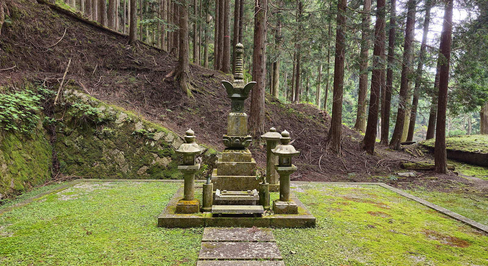 We wished to visit Mt. Hiei in the NE of central Kyoto, but were not ready to hike up to it, given the high summer temperatures. We thus chose to take, first, the Eizan Cable Car and, then, the Eizan Ropeway, up to a place near the top of Mt. Hiei. Walking eastwards from there, we first made it to the actual top of Mt. Hiei, before descending along a hiking trail to the graveyard behind the Enryakuji Temple. Walking through this graveyard in the forest, early in the morning, was a special moment. After visiting the Enryakuji Temple (several of the buildings), we then hiked down the mountain along a hiking trail towards the East (in parallel to the cable car that comes up from Sakamoto). It was impressive to see that quite a few others hiked in the opposite direction, i.e., up the mountain >>>
Steinfjellet from Osavatnet (via Vossavardane)
- Datum:
- 09.06.2025
- Tourcharakter:
- Wanderung
- Tourlänge:
- 7:00h
- Entfernung:
- 16,4km
 We decided to make a hike to Steinfjellet in the east of Gulltjørna. After comparing different approach options, we decided to hike Steinfjellet from Osavatnet (via Vossavardane). This gave us also the opportunity to explore the direct ascent to Vossavardane from Songstaddalen via Gasebrekkene. After parking near Osavatnet, we thus first hiked into the direction of Songstaddalen (northwest of Svartavassrinden). From Songstaddalen, we then entered the lower stretches of Gasebrekkene (steep, yes, but well doable -- without a trail, of course). Getting up to the saddle between Hotten in the south and Tjørndalsskaret in the north proved well possible, while steep as expected. The only one point to consider is that it's not all that clear how to avoid a bush war up there (possible, but one >>>
Melderskin from Grønestølen (via Store Laurdalen)
- Datum:
- 17.05.2025
- Tourcharakter:
- Wanderung
- Tourlänge:
- 12:00h
- Entfernung:
- 11,4km
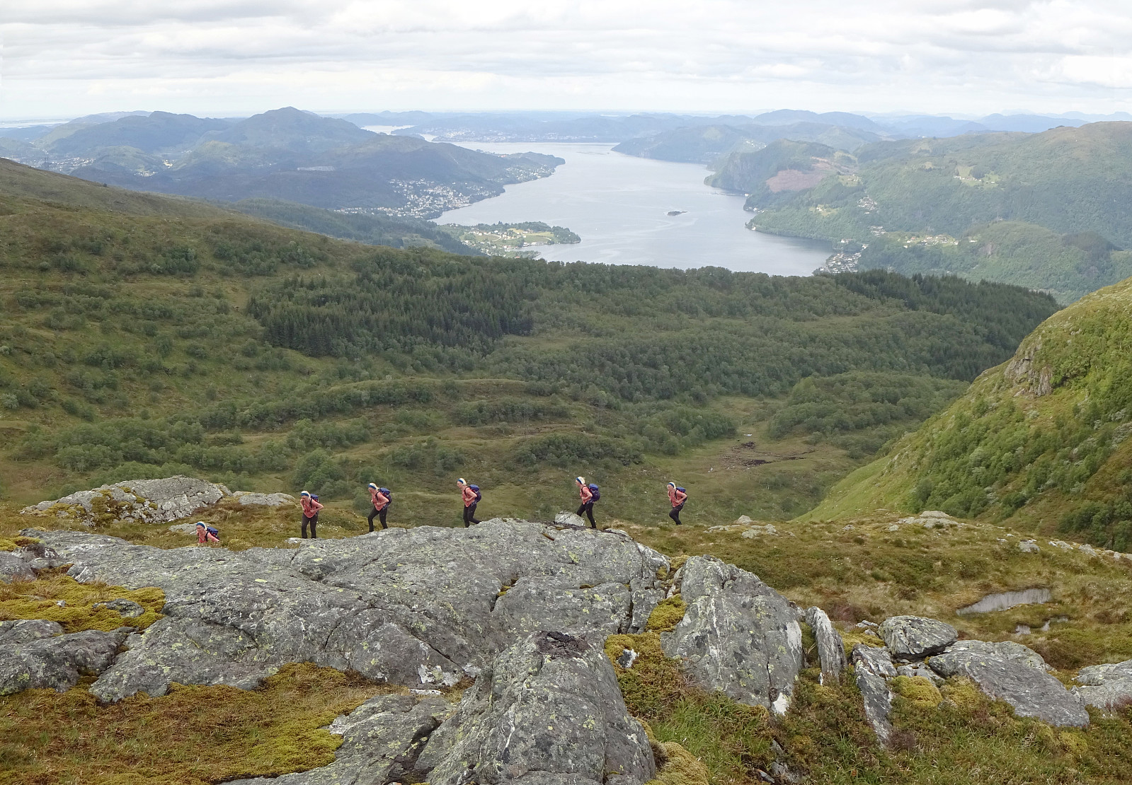
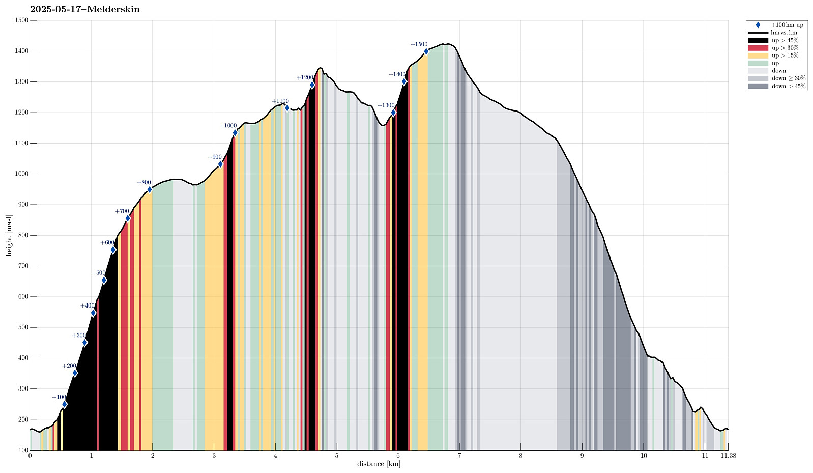 For quite a while we had talked about hiking Melderskin one day. Would we have guessed that our window of opportunity to do so would open up exactly on May 17? With an excellent weather forecast in our hands, we decided on rather short notice that we would leave Bergen after work on May 16, taking the fast ferry to Rosendal. We then stayed at Grønestølen over night -- what a nice place?! From there, we then started our hike to Melderskin in the morning of May 17. Our plan was (first) to try getting up to Store Laurdalen in the northwest of Laurdalselva (without a trail). We had studied the map in quite some detail to support our assessment that this should be possible (even though the terrain is certainly very steep there in places). From there, we had (first) in mind to continue the >>>
Herlandsfjellet via Geitaryggen
- Datum:
- 04.05.2025
- Tourcharakter:
- Wanderung
- Tourlänge:
- 3:15h
- Entfernung:
- 7,9km
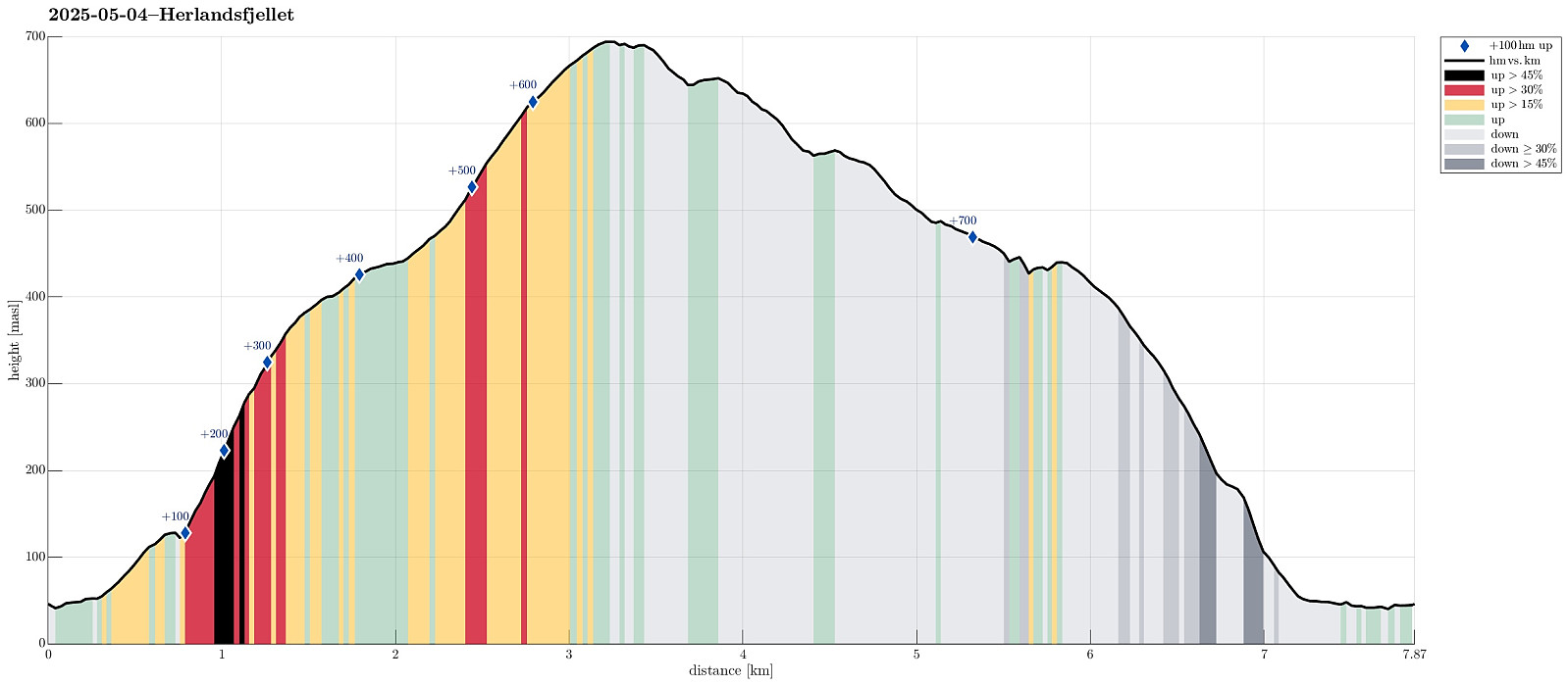 I wished to explore a new ascent route to Herlandsfjellet, as well as a new descent route, also. I drove eastwards out of Bergen to connect with E16 at Indre Arna. Right next to the large bridge to Osterøy, I parked the car and started my hike. After only walking a few meters in westerly direction, I passed a few houses at Geila in order to find a connection to Geitaryggen. Indeed, it was well possible and quite enjoyable to cross over to Tverrelva, basically following the traverse where also a water pipe is laid for the houses at Geila. Quickly, I had made it to Tverrelva and crossing over it was also no problem at all. In the southwest of Tverrelva, I then started my ascent to Geitaryggen "for real" (no trail, but very well possible to ascend via this ridge -- yes, it's a >>>
Heihillerhornet, Kjerringafjellet, and Ottanosi
- Datum:
- 26.04.2025
- Tourcharakter:
- Wanderung
- Tourlänge:
- 5:30h
- Entfernung:
- 10,7km
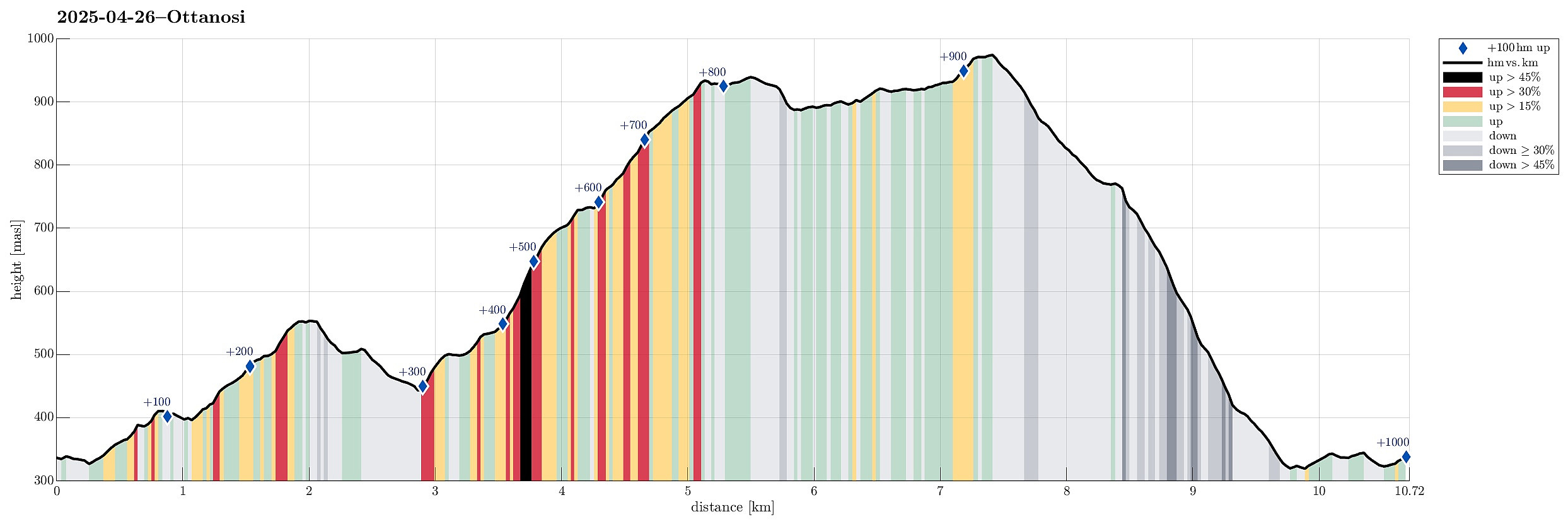 We expected nice weather and thus planned for a nice hike! :-) We took the ferry from Hatvik near Os in the south of Bergen to Venjaneset in Fusa. From there, we first drove to Eikelandsosen and then to Holdhus, where we left road 48 to get up to the parking place at Heihillervegen (one pays some road fee for driving up there: NOK 75 plus about the same amount "on top" for "lagring og oppslag" as well as for "fakturagebyr"). Our first goal was to hike up to Heihillerhornet and so we "retreated" from the parking place a short stretch along the road to the place, where the trail starts (there's a sign, also). After first finding the trail head, we still managed to get off the trail within only meters from the road! :-) Instead of heading further eastwards, >>>
