Arkiv - dato
Arkiv - aktivitet
-
Annen tur (1)
- Kajakkpadling (1)
-
Annen vintertur (4)
- Trugetur (4)
- Fottur (736)
-
Skitur (4)
- Fjellskitur (4)
-
Sykkeltur (123)
- Blandet sykling (41)
- Gatesykling (5)
Arkiv - Etter geografi
"Peakbookvenner"


Lister jeg samler etter
-
Bergen ≥ 50m pf. og ≥ 100 m.o.h.
(87/89)
 97%
97% -
Most dominating tops of the Bergen peninsula
(68/75)
90%
-
Utvalgte topper og turmål i Bergen
(313/347)
90%
-
Alle topper i Bergen
(356/398)
89%
-
Opptur Bergen
(100/113)
88%
-
De syv fjell rundt Bergen
(6/7)
85%
-
Sund ≥ 50m pf.
(14/18)
77%
-
Os ≥ 50m pf.
(25/34)
73%
-
Søyler (fastmerker) i Bergen
(68/100)
68%
-
Fjell ≥ 50m pf.
(21/32)
65%

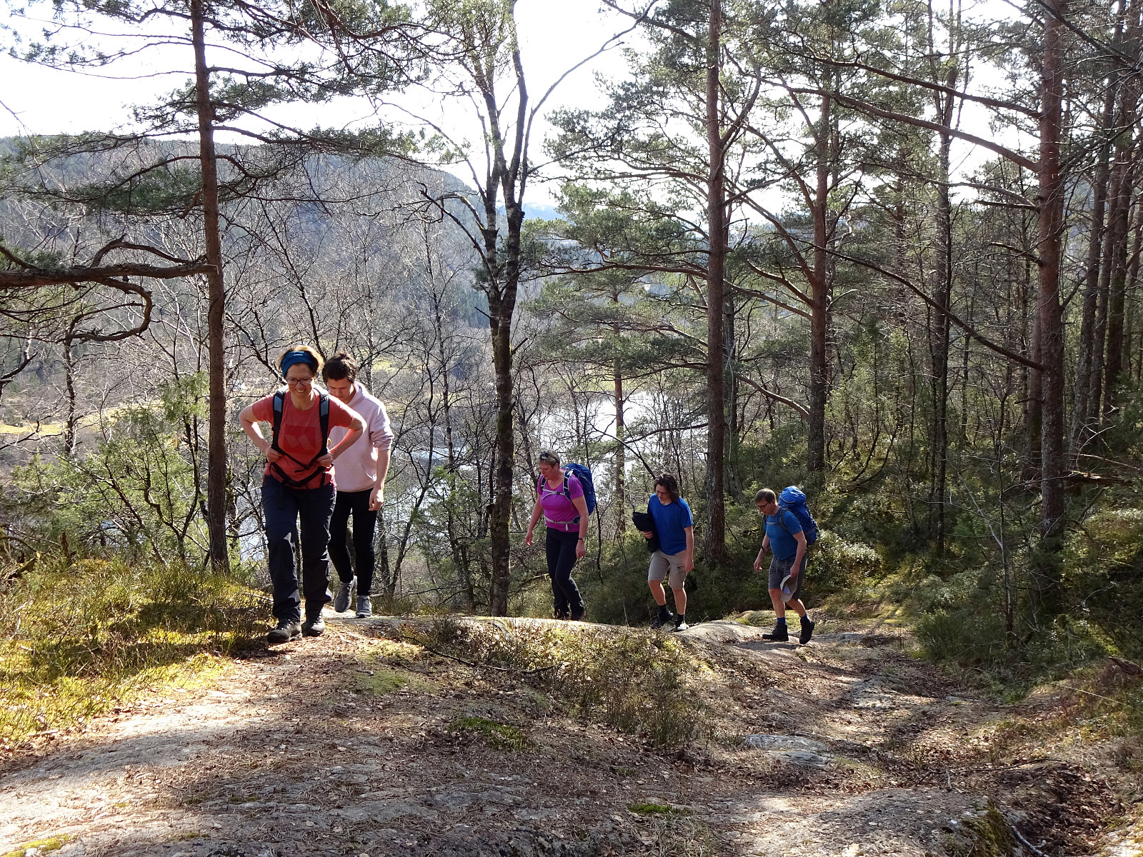
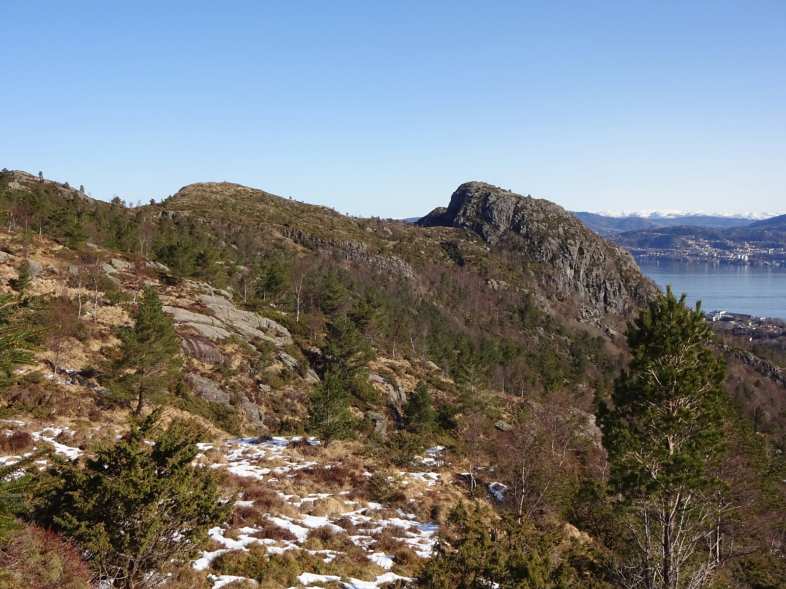
Holdhusfjellet from Raunekleiva
- Dato:
- 24.04.2021
- Turtype:
- Fottur
- Turlengde:
- 5:00t
- Distanse:
- 11,4km
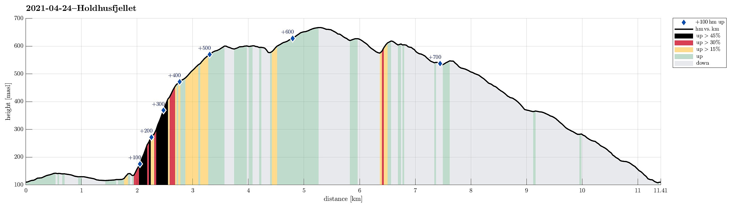 The plan was to hike Holdhusfjellet from the south. To do so, we took the car into the east of Bergen, driving along E16 first. At Trengereid, we changed to road #7, driving towards Samnanger (via Gullbotn). After passing by Gullbotn, but before getting all the way down to Samnanger (just east of Hisdalen), we parked right next to the recycling area at Raunekleiva (we expected to come down there, following the prominent trail that leads to Raudvatnet from there). From there, we first walked along the old road back along Samnangervegen in westward direction. Walking by Leitet and Hisdalen, we approached the steep southeastern slopes of Holdhusfjellet. Ahead of time, we had discussed about how to actually ascend to Holdhusfjellet. One idea was to ascend to Akselskaret, first, and from >>>
Tveitafjellet from Fotlandsvåg
- Dato:
- 18.04.2021
- Turtype:
- Fottur
- Turlengde:
- 3:00t
- Distanse:
- 8,3km
 We started in Fotlandsvåg on the north of Osterøy, right next to Fjordslottet (between Herlandsvatnet in the south and Fotlandsvågen in the north), first walking up to the fotball field (in the west of Fotlandsvåg), and from there, diagonally upwards, along a forest road in southern direction. At a bit more than 50mosl, we then stepped onto a marked trail that leads up to Fotlandssætra (about 200mosl) and from there further up to Vetaskaret. While nobody could have asked for a nicer day, with spring temperatures and lots of sun, we soon found the somewhat steep ascent towards Vetaskaret covered in (relatively hard) snow. With a bit of care, however, and/or the right shoes, we nonetheless made our way up without major difficulties. At Vetaskaret, we briefly contemplated a short detour >>>
Lyderhorn via Lia
- Dato:
- 17.04.2021
- Turtype:
- Fottur
- Turlengde:
- 2:00t
- Distanse:
- 3,9km
 We wished to use the very nice morning for a short hike and decided to try a new ascent to Lyderhorn (via Lia). We parked next to Lyderhornsveien, not far in the southwest of the big highway cross (basically at the saddle in the east of Skarpafjellet). From there, we first walked along Lyderhornsveien (in northeastern direction and parallel to the highway to Bergen) until we came to the lower ends of Lia, i.e., the quite steep eastern side of Lyderhorn (between the top of Lyderhorn and Liavatnet on the other side of the highway). On the map, it had looked as if it should be possible to ascend up to Lyderhorn via Lia, starting in northwestern direction first (just west of a little stream that is marked on the map) until one arrives at the a little less steep slopes that connect the top of >>>
Tellevikafjellet and Nordgardsfjellet
- Dato:
- 11.04.2021
- Turtype:
- Fottur
- Turlengde:
- 3:30t
- Distanse:
- 9,7km
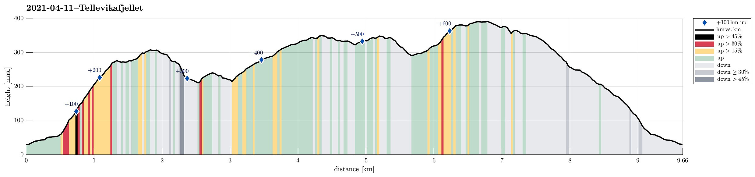 With the perspective of a nice winter day ahead of us, we decided to try something new (again). According to some exchange with friends not long ago, we planned to walk up Tellevikafjellet from the north, i.e., from Tellevik. We took the car from Bergen towards the north (along E39), following the main road towards Norhordlandsbrua. At the last exit before the bridge, where one can leave towards Hordvik (in the northeast) or Salhus (in the southwest), we left E39 and parked basically at the first convenient opportunity to do so, right next to the roundabout underneath the main road. From there, we then followed a simple forest road, which extends parallel to E39 on its northeastern side, until we came to a passage under E39 that we used to get to the other side (Tellevikafjellet is on the >>>
Crossing Borga from/to Borgo
- Dato:
- 02.04.2021
- Turtype:
- Fottur
- Turlengde:
- 4:00t
- Distanse:
- 10,5km
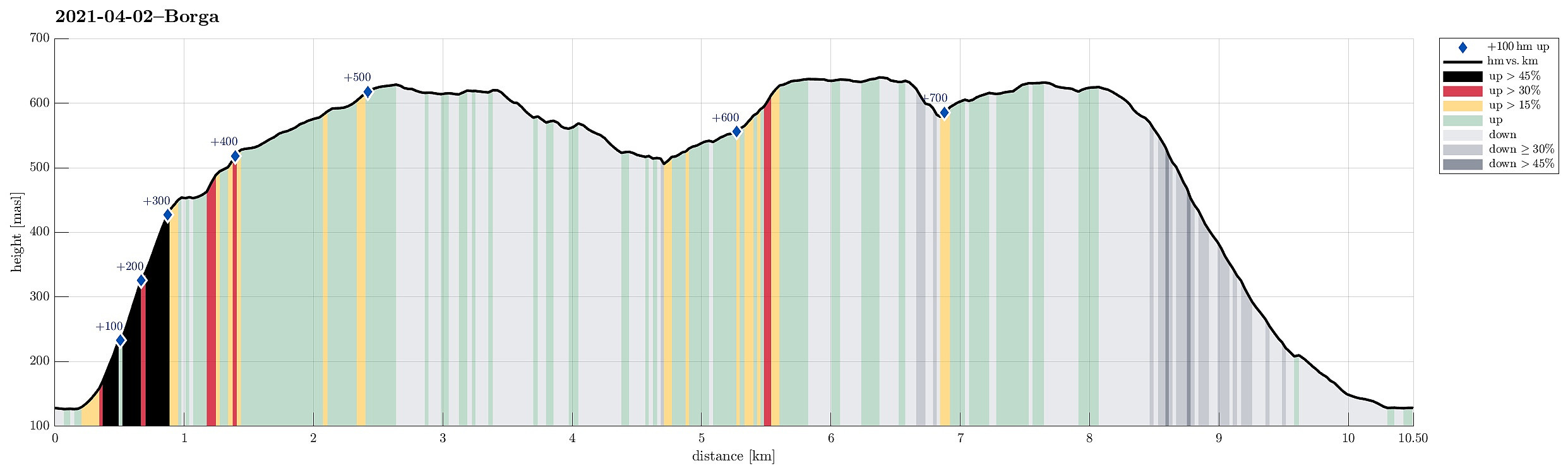 Since it had been a while, since we last were on Borga, we thought that we could pay this nice mountain near Arna another visit. We left Bergen towards the East, passing by Grimevatnet along the way. Near Haukeland, we turned left from Hardangervegen, heading into Langedalen. At Borgo, we parked next to the road and started our hike. From the road we had already double-checked that ascending along the southern (steep) ridge of Borga (south of Kvitnosa) appeared possible (while still a bit challenging). Keeping a little east of the actual ridge, we ascended more or less directly up through some half-open forest. Avoiding cliffs, this way, we managed to straight-forwardly ascend towards Kvitenosa, stepping up over mostly grass in between generously spaced trees. This ascent is indeed quite >>>
Crossing Midtfjellet and Lørdagsknausen
- Dato:
- 01.04.2021
- Turtype:
- Fottur
- Turlengde:
- 5:00t
- Distanse:
- 14,6km
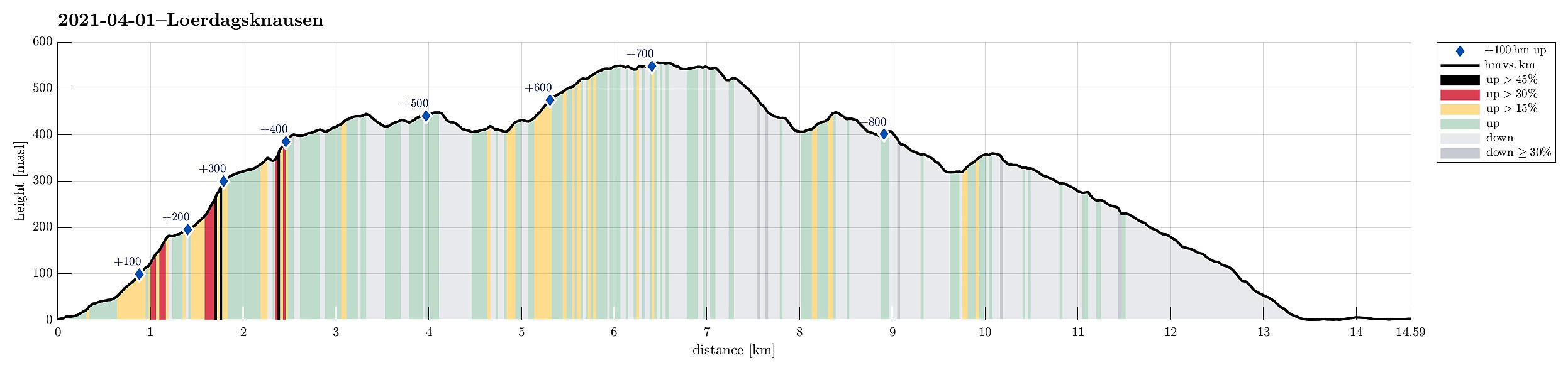 The idea was to cross Midtfjellet, between Fløyen and Rundemanen, from north to south. We took a bus to Skuteviken and walked up towards Mulen from there. Instead of stepping up to the dam on the north side of the valley, where the main route is, we went up on the Breistølen side, passing by the little water reservoir at Mulen on its southern side. Once on its eastern side, in the lower parts of Skredderdalen, we crossed the little stream and connected with the main route. Following this main path upwards (it's steep there, but a common trail, nonetheless), we came to Nedrediket and "road" Byfjellene there. Crossing the little dam on the northwestern side of Nedrediket, we continued our way upwards until we were right next to the northern end of Nordre Midtfjellet. To get >>>
Hetlebakksåta and Erviknipa from Breistein
- Dato:
- 28.02.2021
- Turtype:
- Fottur
- Turlengde:
- 2:30t
- Distanse:
- 7,2km
 We somehow thought that it may be worthwhile to explore the ridge in the south of Erviknipa, southeast of Hetlebakksåta. We drove to Breistein via Åsane and parked quite a bit south on Breisteinvegen. According to our plan to hike a round, we first walked northwards (towards Nygård) to find an opportunity for ascending to Hetlebakksåta. When looking at the map before leaving, we had estimated that it should be possible to ascend towards Fosseskaret there and indeed this is well possible from Nygård (the "trails" up there are not very clear, but possible to find and certainly also possible to ascend, just a bit steep). At about 130mosl, we entered the little valley that comes down from Fosseskaret, right where there is a little waterfall down towards Breistein. At Fosseskaret, >>>
Rounding Storavatnet in the south of Kallestad
- Dato:
- 24.01.2021
- Turtype:
- Fottur
- Turlengde:
- 3:30t
- Distanse:
- 10,3km
 After discussing a few ideas for another nice hike, we eventually decided to drive out to Øygarden, once again, and explore the region near Kallestad again. We thought that the available daylight should be enough to attempt a round around Storavatnet in the southwest of Kallestad. Driving west from Bergen, you get, after a bit, to Sotra. There, turning left, brings one via Fjell further south. At Trengereid, we then turned right in order to drive out to Kallestad, where we parked near Grendahuset. Since our plan was to round Storavatnet in counterclockwise direction, we first walked out of Kallestad in western direction, passing by Vassenden, south of Stølstjørna. There, instead of further following the trail into the direction of Kjereidet, we just walked up the first little hill, >>>
Herlandsfjellet, Skåldalsfjellet, and Skåldalsnipa
- Dato:
- 03.01.2021
- Turtype:
- Fottur
- Turlengde:
- 4:30t
- Distanse:
- 9,0km
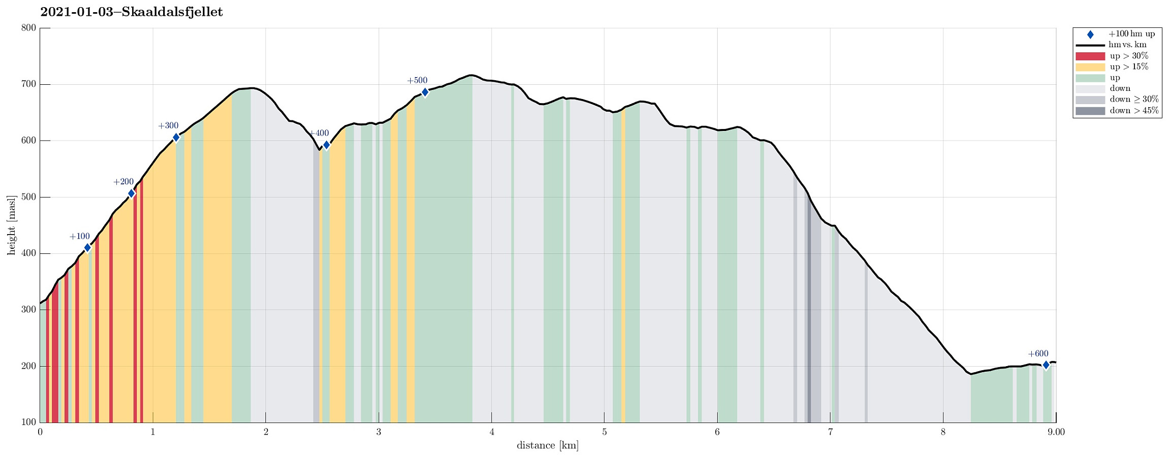 This Sunday was predicted to come with blue skies and nice winter weather, and so it was! The day before we had arranged for a joint hike up Skåldalsfjellet to catch a good amount of winter sun, while also having some good time in not too deep snow. In order to cross over Skåldalsfjellet (from northeast to southwest), we started at the north-side of Osavatnet, almost at the very end of Gullfjellsvegen, where many of those, who venture into th Gullfjellet-mountains, park and start. Instead of walking towards Gullfjellet, however, we turned towards Ormarinden, a nice ridge that comes down from Herlandsfjellet in the north of Osavatnet. This ridge has a very nice trail on it, making the ascent to Herlandsfjellet straight-forward and non-difficult. At the very top of Herlandsfjellet, we >>>
Liatårnet from Fjell Festningen
- Dato:
- 30.12.2020
- Turtype:
- Fottur
- Turlengde:
- 4:00t
- Distanse:
- 10,5km
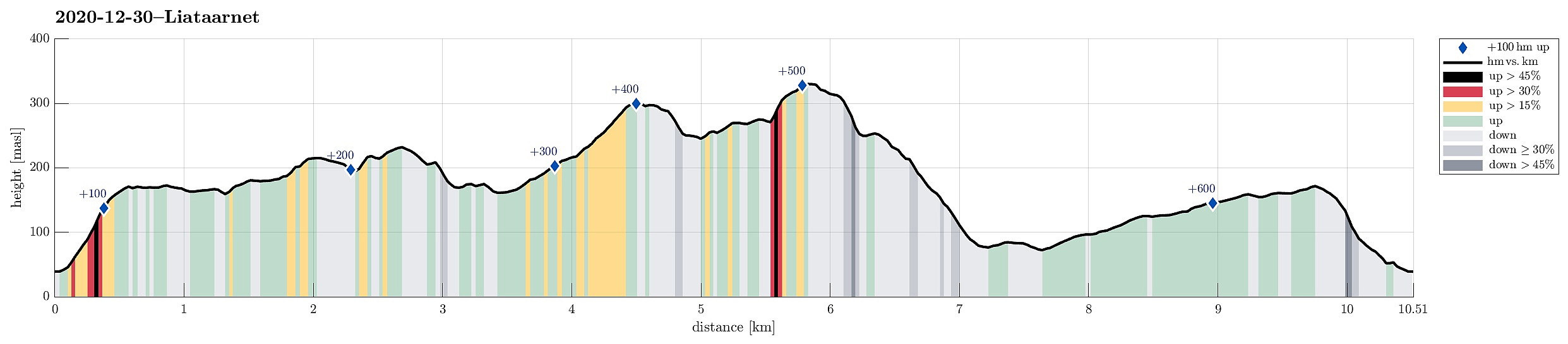 Even though it was already a little later on the day (not a great lot of daylight left), we still wished to make a nice hike somewhere in the neighborhood. We then arrived at the following: first, we would ascend to Fjell Festningen (from Søre Fjell), then walk over to Pyttane and Liatårnet, before eventually returning via Fjell Festningen, again. And so we did it. :-) After using road 555 from Bergen towards Sotra (in western direction), we turned left (southwards) on Sotra, arriving in Fjell soon after that. Continuing along road 560 further southwards (from Fjell for about half a kilometer), we soon came to Søre Fjell, where we found a parking place right next to the road. From there, we followed a properly marked trail (in eastern direction), ascending to Fjell Festningen within >>>
