Arkiv - dato
Arkiv - aktivitet
-
Annen tur (1)
- Kajakkpadling (1)
-
Annen vintertur (4)
- Trugetur (4)
- Fottur (736)
-
Skitur (4)
- Fjellskitur (4)
-
Sykkeltur (123)
- Blandet sykling (41)
- Gatesykling (5)
Arkiv - Etter geografi
"Peakbookvenner"


Lister jeg samler etter
-
Bergen ≥ 50m pf. og ≥ 100 m.o.h.
(87/89)
 97%
97% -
Most dominating tops of the Bergen peninsula
(68/75)
90%
-
Utvalgte topper og turmål i Bergen
(313/347)
90%
-
Alle topper i Bergen
(356/398)
89%
-
Opptur Bergen
(100/113)
88%
-
De syv fjell rundt Bergen
(6/7)
85%
-
Sund ≥ 50m pf.
(14/18)
77%
-
Os ≥ 50m pf.
(25/34)
73%
-
Søyler (fastmerker) i Bergen
(68/100)
68%
-
Fjell ≥ 50m pf.
(21/32)
65%

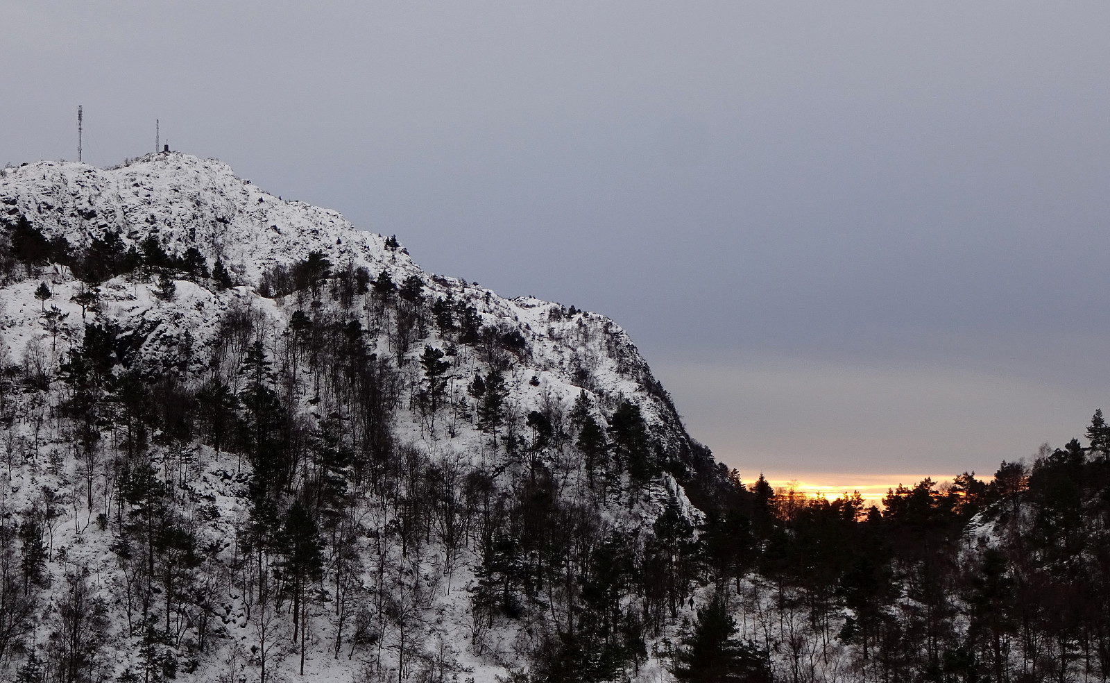
Høgafjellet and Haganesfjellet from Buabrekko
- Dato:
- 26.03.2022
- Turtype:
- Fottur
- Turlengde:
- 3:00t
- Distanse:
- 8,6km
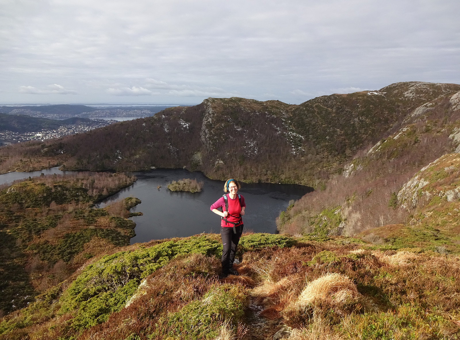
 Høgafjellet and Haganesfjellet from Buabrekko. We parked near Tellnesvegen and walked down Buabrekko, crossing over the stream down from Kvernavatnet where it enters Pollen at its very northern end. On the other, eastern side, a trail leads up to the northern end of Ravnafjellet. Originally, we had planned to find a minor trail that should have forked off somewhere half way up in northeastern direction. Since we had not found this trail, we quickly found ourselves at the northern end of Ravnafjellet. There, we left the trail and continued through some relatively wet terrain northwards. Basically right west of Varden, we then found a good spot for ascending to the "next level", north of Vedatåna. There, we then also connected to a trail that circles Varden in its west. After >>>
Førdesveten from Kleppe
- Dato:
- 20.03.2022
- Turtype:
- Fottur
- Turlengde:
- 3:00t
- Distanse:
- 8,4km
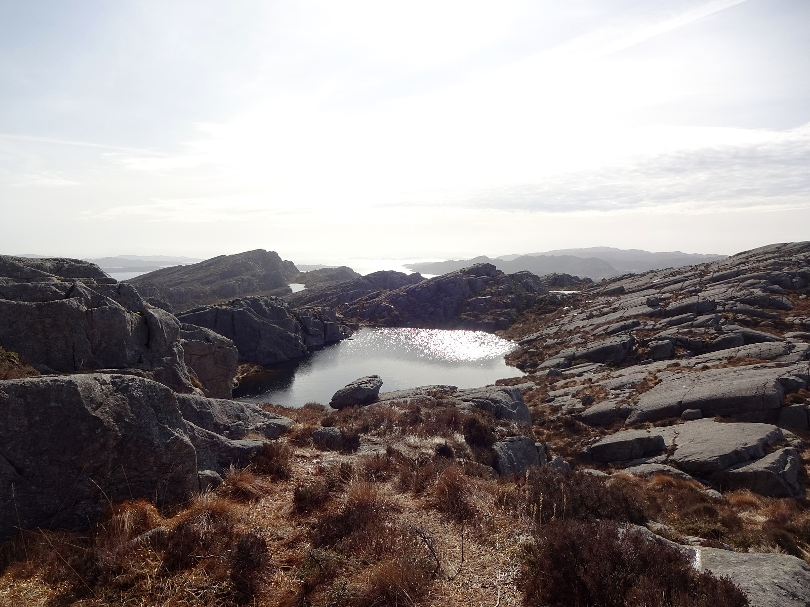
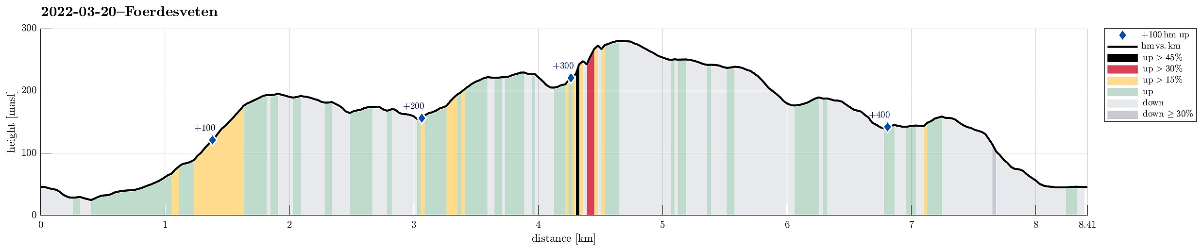 Hike to Førdesveten from Kleppe. We parked near Bjøllhaugen in the east of Kleppe and walked along the road towards Kleppe first. We then turned onto Kleppakslavegen into a northern direction, starting out ascent to Kleppaksla there. A proper trail leads all the way up, just east of Fenadalen. From Kleppaksla we then followed its northern ridge to Ramnaberget, offering some nice views into Kleppadalen in the west and across Trollavatnet in the north east. After passing by Trollavatnet, we crossed the trail leading to Veten from Kleppadalen and ascended to Storevarden in the west of Vetadalen. From there, then without a trail, we continued further north to Middagsberget. Even though Førdesveten has a prominent cliff on its western side, we still had planned to ascend to Veten from >>>
Storsåta and Stangelifjellet from Flaktveit
- Dato:
- 06.03.2022
- Turtype:
- Fottur
- Turlengde:
- 4:00t
- Distanse:
- 11,1km
 Hike to Storsåta and Vinddalen from Flaktveit. We parked where Hjortlandsvegen forks off Flaktveitsvingane and walked a little along Hjortlandsvegen, also crossing over the stream running down there in parallel to the path, until we found the trail that leads up to Storsåta at the lower end of Gjelet. This trail leads all the way up to the saddle at the upper end of Gjelet, right above Øvstebotn, on the western side of Gjelet. Instead of going directly to the saddle and then over and further to Storsåta, we first include a short excursion to Nukane right in the west of the saddle. From Nukane, it was then right over the saddle and up to Storsåta. Further, we then walked along the high ridge in the southeast of Storsåta until we came to Stangelifjellet, separating Setervatnet in the >>>
Orretua and Vardafjellet from Kaland
- Dato:
- 27.02.2022
- Turtype:
- Fottur
- Turlengde:
- 2:00t
- Distanse:
- 5,0km
 Hike from Kaland to Orretua and back to Kaland via Vardafjellet. We had parked near the sports arena of Kaland, walking from there in southeastern direction along Osvegen. Near Smådal, we ascended (without a trail) to the ridge in the northeast of the road. Once up the ridge, we then followed this ridge in northeastern direction (towards Orretua). About half way towards Orretua, we could have switched to a forrest road, which would have led us to Orretua quite easily. Instead, however, we continued along the "high edge" over the much lower extending Bontveitvegen (without a trail). This, first, was straight forward and easy. To connect, then, to Orretua, however, was a bit more challenging (but not really difficult). From Orretua, we then followed a nice trail to Vardafjellet >>>
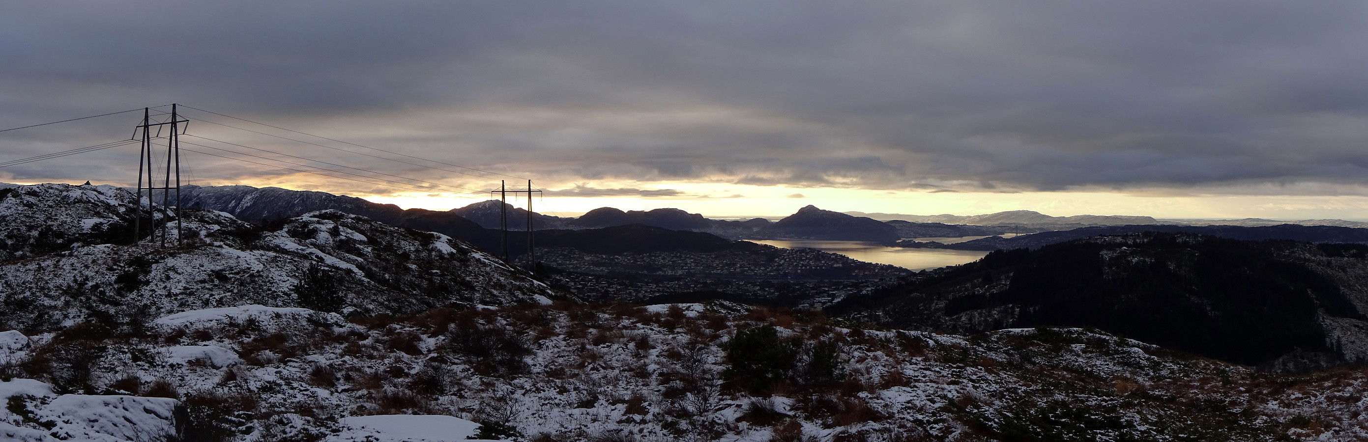
From Eidsvåg via Orretua and Rundemanen to Bergen
- Dato:
- 30.01.2022
- Turtype:
- Fottur
- Turlengde:
- 4:00t
- Distanse:
- 11,0km
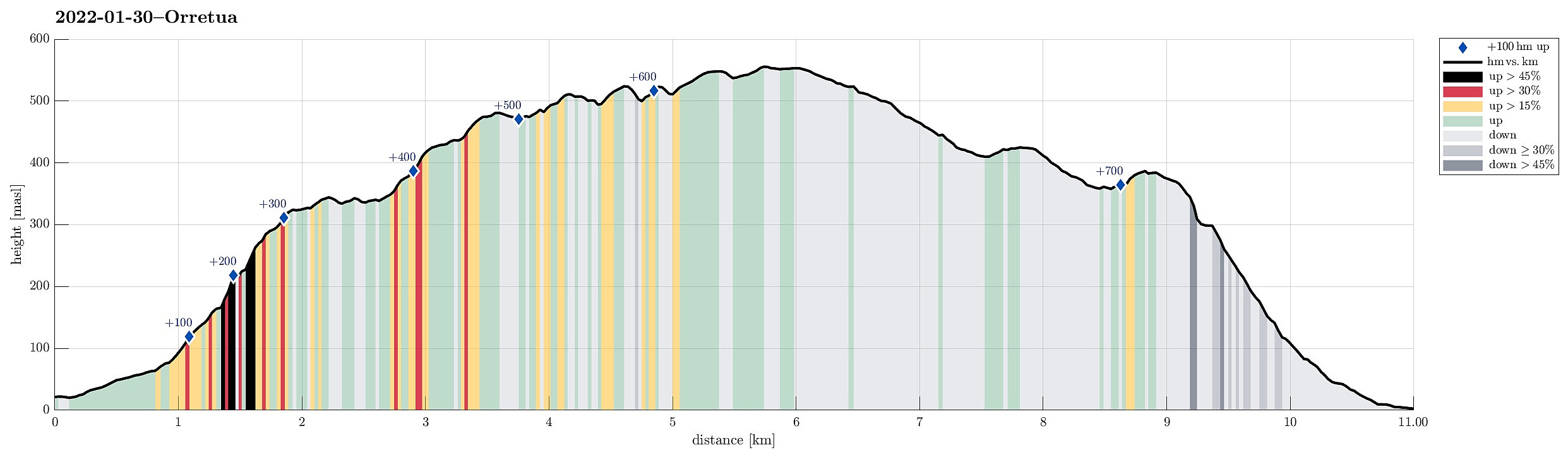 Winter hike from Eidsvåg (the bus stop along Åsaneveien) in the north of Bergen via Orretua, Kvitebjørnen, and Rundemanen, to Bergen. From the bus stop, we followed first Munkebotn up to Langevatnet, where we crossed the stream towards the other, eastern side, where the somewhat steep ascent to Orretua starts. Following the ridge into the direction of Rundemanen, we came by Dræggehytten from where we continued up to Kvitebjørnen. From Kvitebjørnen, we crossed Lavet and came by Kåken before arriving at Rundemanen. From there, we descended to Bergen, passing by Brushytten. Instead of walking down one of the main routes to Bergen, however, we descended via Fløyvarden and over the ridge down to Mulen. While mostly without any problems, this descent along the northwestern ridge from >>>
Høgstefjellet
- Dato:
- 25.12.2021
- Turtype:
- Fottur
- Turlengde:
- 2:00t
- Distanse:
- 5,0km
 A nice winter hike up to Høgstefjellet in the north of Åsane, starting from the recycling station along Salhusvegen and via Bruknappen right northeast of the starting point. Up and down (via Vardfjellet i Åsane) the same trail.
Selected photos are available as Google photo album .
See also the related FB-page Hiking around Bergen, Norway .
Petter Bjørstad has a useful page about Høgstefjellet and another one about Veten i Åsane , and also web page WestCoastPeaks.com provides useful information about Håstefjellet (Høgstefjellet), Tellevikafjellet, and Nordgardsfjellet as well as about Veten i Åsane .
A nice winter hike up to Høgstefjellet in the north of Åsane, starting from the recycling station along Salhusvegen and via Bruknappen right northeast of the starting point. Up and down (via Vardfjellet i Åsane) the same trail.
Selected photos are available as Google photo album .
See also the related FB-page Hiking around Bergen, Norway .
Petter Bjørstad has a useful page about Høgstefjellet and another one about Veten i Åsane , and also web page WestCoastPeaks.com provides useful information about Håstefjellet (Høgstefjellet), Tellevikafjellet, and Nordgardsfjellet as well as about Veten i Åsane .
Visiting TOBRIK
- Dato:
- 19.12.2021
- Turtype:
- Fottur
- Turlengde:
- 3:30t
- Distanse:
- 9,2km
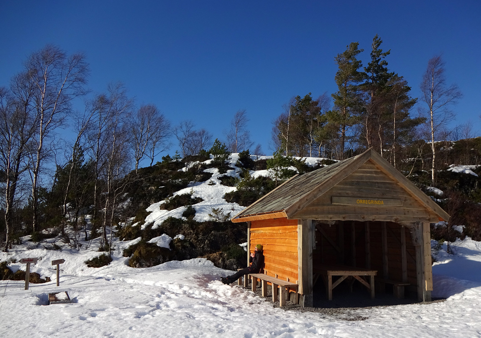
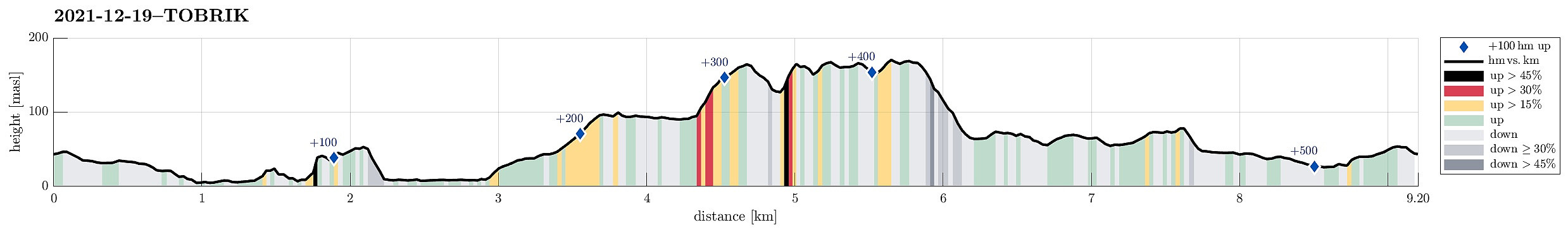 After discussing a few different ideas, we eventually settled on something quite basic: a little round through Kanadaskogen to enjoy the nice December day that also happened to be a Sunday! :-) Starting from Varden in the south of Fyllingsdalen, we headed first to Gjeddevatnet. Following its shoreline for a bit, we rounded Gjerdsvika to get to Fueneset. From there, and in order to get further north (to Bjørndalsvatnet), we had to pass by Elvareidet. While the one of us, who's smart, respected our knowledge of the cliffs in the east of Elvareidet, which require that one passes "over the top" instead of "down around", and started this small ascent right away from Furuneset, the other one, who wished to "double-check", descended again to Gjeddevatnet, just to >>>
Liatårnet from Li
- Dato:
- 11.12.2021
- Turtype:
- Fottur
- Turlengde:
- 2:30t
- Distanse:
- 5,3km
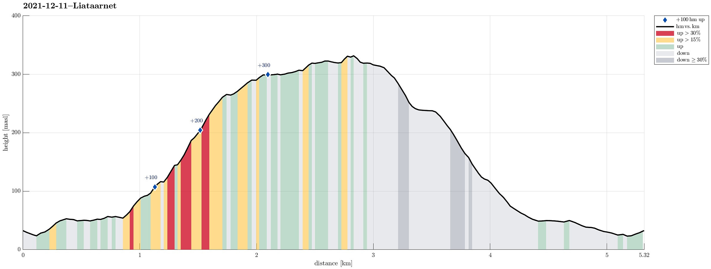 We expected some sunshine (not any long day, though, of course) and thus headed for some snow near Bergen! :-) Remembering a very nice winter hike up to Liatårnet in Jan. 2019 , we aimed at Liatårnet, again, but this time via a slightly different route. Also this time, we drove to Li (on the eastside of Liatårnet) and parked near Liaskjærshallen right next to Liaskjervegen at Liaskjeret. From there, we first walked back a little (north along Liaskjervegen) until we turned left (onto Elvabakkvegen). After walking up this road for a few meters, the road splits into two in a T-junction; there, straight onwards, one finds a trail head from which one can get behind the houses in westwards direction (for ex., towards Trollhaugen in the southwest). Our plan was to ascend into the direction of Liatårnet from there, so we did not >>>
White Løvstakken
- Dato:
- 05.12.2021
- Turtype:
- Fottur
- Turlengde:
- 1:00t
- Distanse:
- 5,5km
 We needed a bit of fresh air and thus decided to make a quick excursion from Melkeplassen, between "downtown" Bergen and Fyllingsdalen. We parked along Monrad Mjeldes vei and followed the signs towards Løvstakken until we arrived at the upper end of Løvstien. Crossing Løvstien, we continued upwards along the northern ridge that leads to Ravnefjellet. There, we decided to also include Løvstakken. Following one of the major trails, we soon after arrived at the top of Løvstakken. Back down, we first followed the same trail, but instead of connecting to Ravnefjellet, again, we followed a trail into the direction of Skitnedalen. Crossing some of the local heights there, we continued further northwards along of the ridges. Before descending too much into the direction of Bergen, >>>
Round around Meland church
- Dato:
- 21.11.2021
- Turtype:
- Fottur
- Turlengde:
- 4:00t
- Distanse:
- 8,6km
 Expecting a nice November Sunday, we aimed at a round around Meland church near Knarvik in the north of Bergen. Driving along E39 from Bergen brought us across Salhusfjorden with the help of Nordhordlandsbrua. As soon as we touched ground on Flatøy, again, we changed to Rosslandsvegen, leading westwards into the direction of Meland and Holsnøy. Near Frekhaug, we turned right (onto the comparably narrow road to Meland). After crossing over from Dale to Meland, we parked near Meland church and started our hike from there. The first sub-goal of the day was Salbukletten in the northwest of Meland. We passed by Erstad, first, and then ascended from there to Salbukletten (into northwestern direction from Erstad). This ascent, even though without trail, was nice and easy! On Salbukletten, >>>
