Arkiv - dato
Arkiv - aktivitet
-
Annen tur (1)
- Kajakkpadling (1)
-
Annen vintertur (4)
- Trugetur (4)
- Fottur (740)
-
Skitur (4)
- Fjellskitur (4)
-
Sykkeltur (137)
- Blandet sykling (51)
- Gatesykling (9)
Arkiv - Etter geografi
"Peakbookvenner"


Lister jeg samler etter
-
Bergen ≥ 50m pf. og ≥ 100 m.o.h.
(87/89)
 97%
97% -
Most dominating tops of the Bergen peninsula
(68/75)
90%
-
Utvalgte topper og turmål i Bergen
(316/350)
90%
-
Alle topper i Bergen
(357/398)
89%
-
Opptur Bergen
(100/113)
88%
-
De syv fjell rundt Bergen
(6/7)
85%
-
Sund ≥ 50m pf.
(14/18)
77%
-
Os ≥ 50m pf.
(25/34)
73%
-
Søyler (fastmerker) i Bergen
(68/100)
68%
-
Fjell ≥ 50m pf.
(21/32)
65%

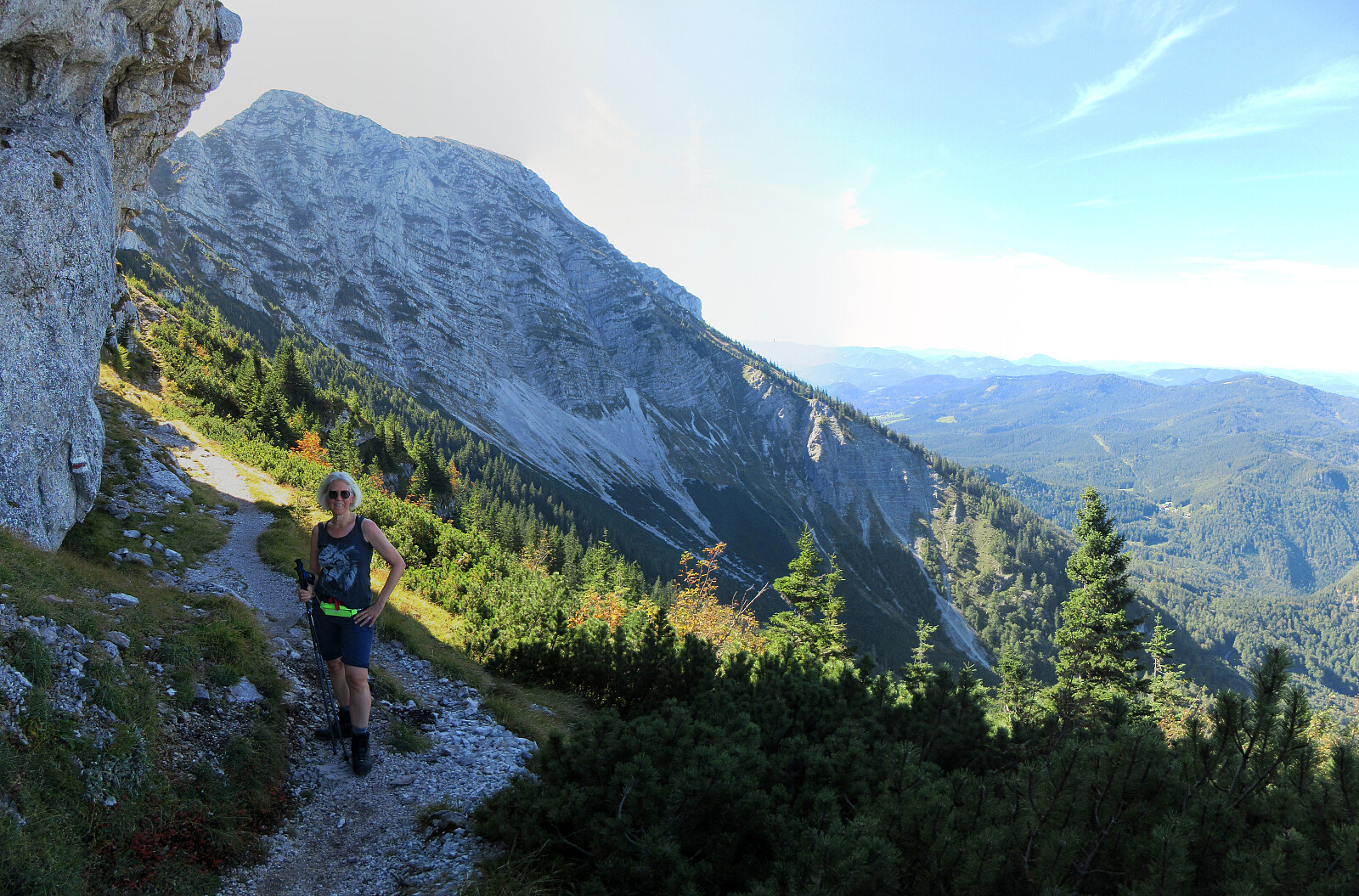
Hochstaff & Reisalpe from Ebenwaldhöhe
- Dato:
- 27.09.2025
- Turtype:
- Fottur
- Turlengde:
- 4:00t
- Distanse:
- 9,7km
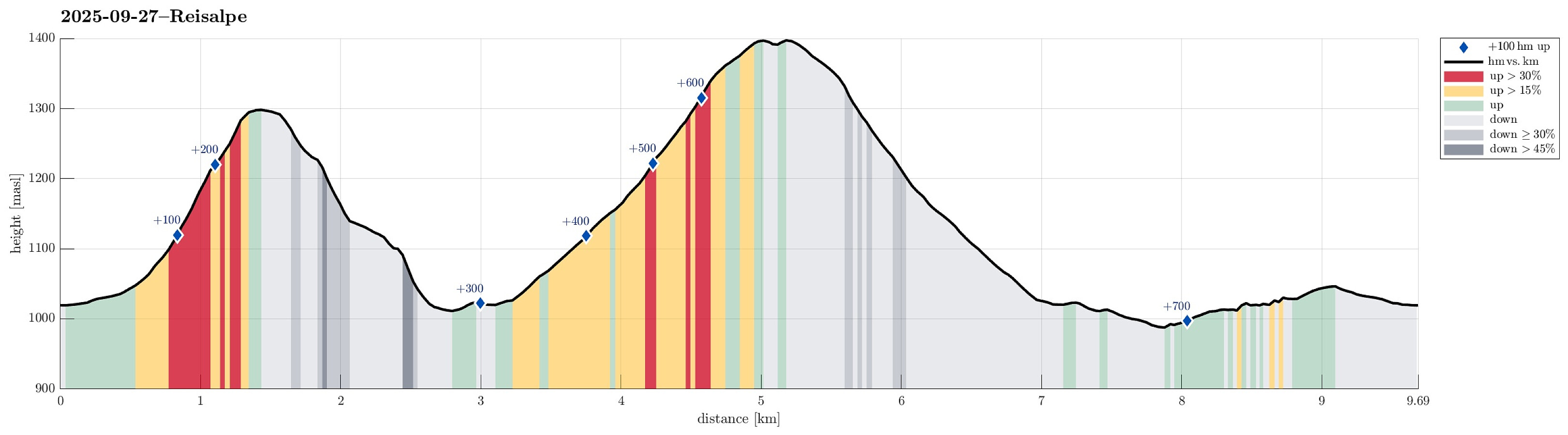 Expecting some nice weather on this Saturday, we aimed at a nice hike not too far from Vienna. After comparing a few opportunities, we ended up with driving to Ebenwaldhöhe in the west of Kleinzell and hiking from there to Reisalpe, also including an ascent to Hochstaff "on the way". For some 400 meters, we first followed a simple road, mostly in southern direction, across Ebenwaldhöhe, before then deviating from the main track (which leads around Hochstaff on its northwestern side) to include an ascent to Hochstaff, also. This route is not exactly well marked and one better knows where to go; despite of this detail, however, it's still all on proper trails to get up to Hochstaff from Ebenwaldhöhe (the ascent to Hochstaff is quite steep, but still nicely within "regular >>>
Ötscher via Rauher Kamm from Lackenhof
- Dato:
- 21.09.2025
- Turtype:
- Fottur
- Turlengde:
- 6:00t
- Distanse:
- 15,9km
 After spending the night involuntarily at an airport hotel in Amsterdam, we got to Vienna early on this Sunday, expecting a nice day. We thus rushed to get into the mountains, driving to Lackenhof in the southwest of Vienna. Our plan was to make a nice hiking round up and down Ötscher, using its northeastern ridge (Rauher Kamm) as the ascent route, while then descending via the Ötscherschutzhaus in the southwest of the mountain. Once in Lackenhof, we aimed at the large parking lot in Weitental to leave the car behind -- just to find that it was completely full with cars (while the combination of Sunday with nice weather and our relatively late arrival could have let us anticipate this situation, we had not). Luckily, one parking place got freed up only minutes after our arrival, letting >>>
Lundåsane from Hausdalen
- Dato:
- 14.09.2025
- Turtype:
- Fottur
- Turlengde:
- 3:00t
- Distanse:
- 5,9km
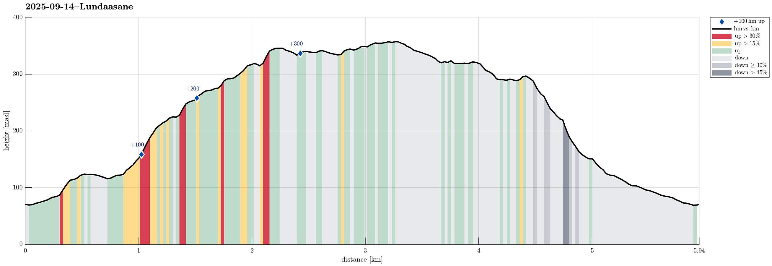 We wished to explore the Hausdalen-side of Lundåsane and thus drove to Hausdalen, where we parked a bit south of Håland. From there, we first walked up a gravel road that extends parallel to Hålandsbekken. About half way up, I decided that I wished to explore Storerinden, in the east of Slokadalen, also. Stepping up to this hill was straight-forward, while not on a trail, though. From Storerinden, while not really a prominent "peak", I still got a nice view towards Hausdalshorgi (it's always nice to see Hausdalshorgi!). I then continued across the ridge to re-connect with the gravel road near the T-junction, where one leg of the gravel road extends a bit further up to Plasset. Instead of following the gravel road any further, though, I used a trail (maybe more a former trail) >>>
Lysehornet from Kismulvegen
- Dato:
- 07.09.2025
- Turtype:
- Fjelltur
- Turlengde:
- 4:00t
- Distanse:
- 6,9km
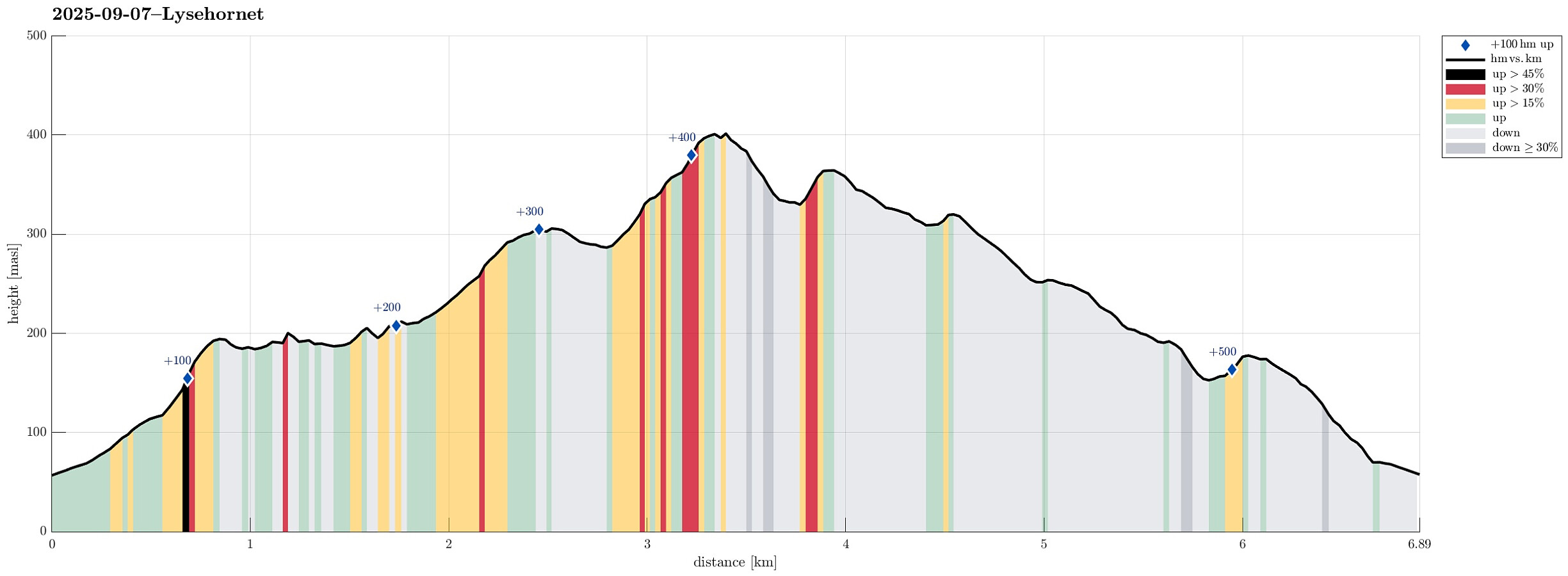 We had the idea to hike Lysehornet from the northeast (from Kismulvegen) and thus drove via Fana to Kalandsvatnet. Near house #47 along Kismulvegen, we parked -- not without an interaction with a man, who made it explicit that he'd wish us to park in Bygarasjen instead. We then started our hike into southwestern direction, first following a side-part of Kismulvegen up and towards Lindedalen. At large, the plan was to get to Lysehornet without a trail, while then taking a trail back down. After passing the upper houses (and quite a bit of rusting garbage of small to large sizes), we eventually made into the forest of Lindedalen. The first high point to reach was Hovåsen and the ascent from the northeast was a bit steep (but well doable). From Hovåsen, the plan was to hike around the >>>
