Archiv - Nach Datum
Archiv - Nach Aktivität
-
Andere Tour (1)
- Kayaking (1)
-
Andere Wintertour (4)
- Schneeschuhtour (4)
-
Fahrradtour (137)
- Fahrradtour Straße (9)
- Fahrradtour gemischt (51)
-
Fußtour (740)
- Bergtour (363)
- Jogging (18)
- Spaziergang (89)
- Wanderung (270)
-
Skitour (4)
- Tourenskilauf (4)
Archiv - Nach Geografie
Peakbookfreunde


Gesammelte Listen
-
Bergen ≥ 50m pf. og ≥ 100 m.o.h.
(87/89)
 97%
97% -
Most dominating tops of the Bergen peninsula
(68/75)
90%
-
Utvalgte topper og turmål i Bergen
(316/350)
90%
-
Alle topper i Bergen
(357/398)
89%
-
Opptur Bergen
(100/113)
88%
-
De syv fjell rundt Bergen
(6/7)
85%
-
Sund ≥ 50m pf.
(14/18)
77%
-
Os ≥ 50m pf.
(25/34)
73%
-
Søyler (fastmerker) i Bergen
(68/100)
68%
-
Fjell ≥ 50m pf.
(21/32)
65%

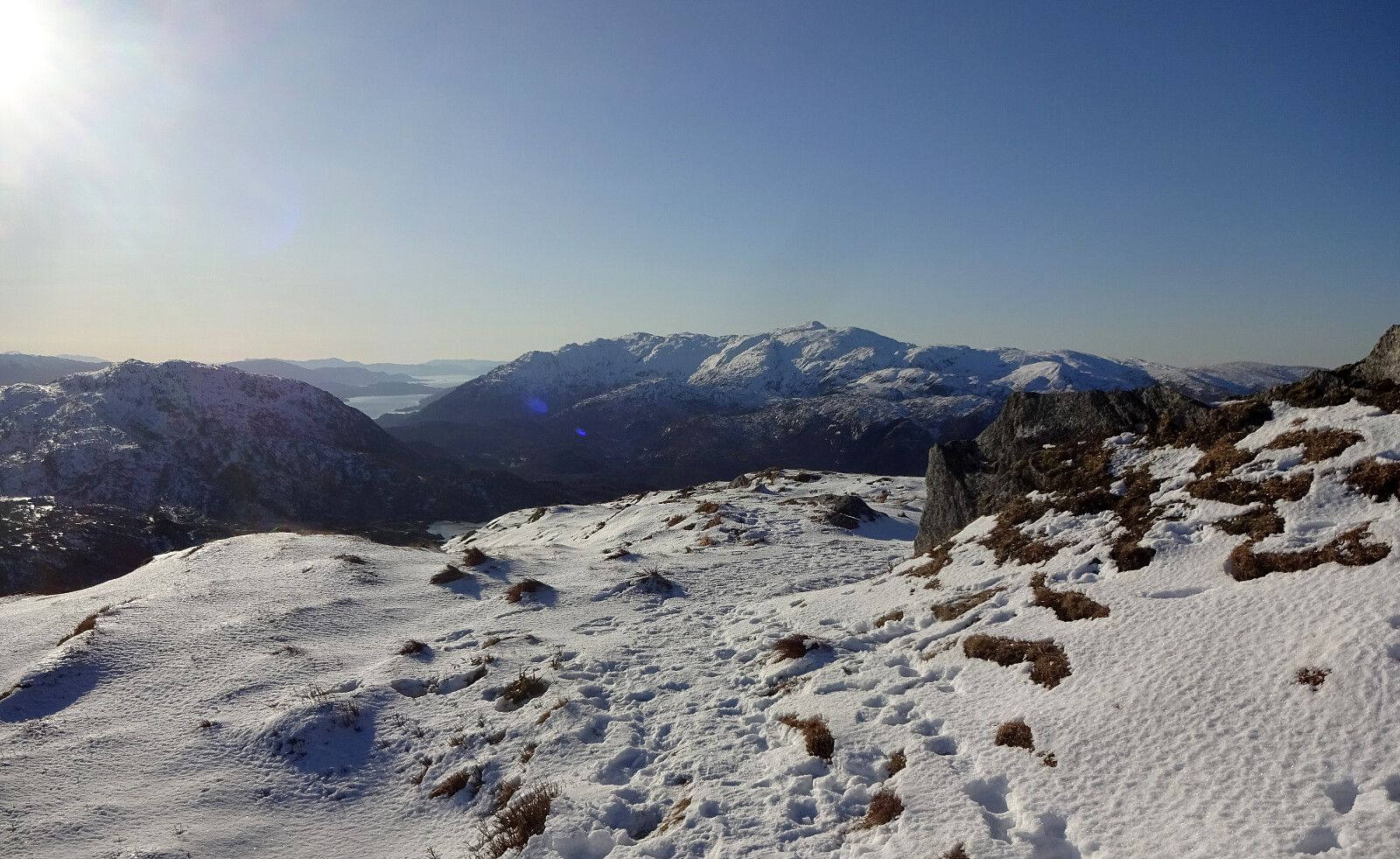
Ulriken via Ulrikseggen
- Datum:
- 23.02.2025
- Tourcharakter:
- Wanderung
- Tourlänge:
- 3:30h
- Entfernung:
- 13,1km
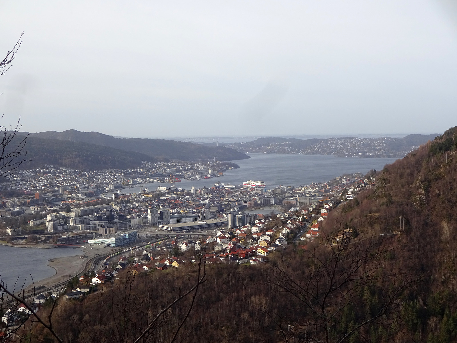 We started near Haukeland hospital in Bergen and first walked around Svartediket to get to the trail head north of Ulrikseggen. While ascending the ridge, we repeatedly enjoyed the amazing vierws across Svartediket and towards Bergen! Once on the heights of Ulriken, the hiking party split into two with one part including the actual top of Ulriken, also (via Ulriksskaret). At the upper end of Ulriksbanen, we refreshed ourselves a little, before walking down the Sherpa trail. Clearly, stepping up to Ulriken via Ulrikseggen is one of the nicer variants up! :-)
Selected photos are available as Google photo album .
See also the related FB-page Hiking around Bergen, Norway .
We started near Haukeland hospital in Bergen and first walked around Svartediket to get to the trail head north of Ulrikseggen. While ascending the ridge, we repeatedly enjoyed the amazing vierws across Svartediket and towards Bergen! Once on the heights of Ulriken, the hiking party split into two with one part including the actual top of Ulriken, also (via Ulriksskaret). At the upper end of Ulriksbanen, we refreshed ourselves a little, before walking down the Sherpa trail. Clearly, stepping up to Ulriken via Ulrikseggen is one of the nicer variants up! :-)
Selected photos are available as Google photo album .
See also the related FB-page Hiking around Bergen, Norway .
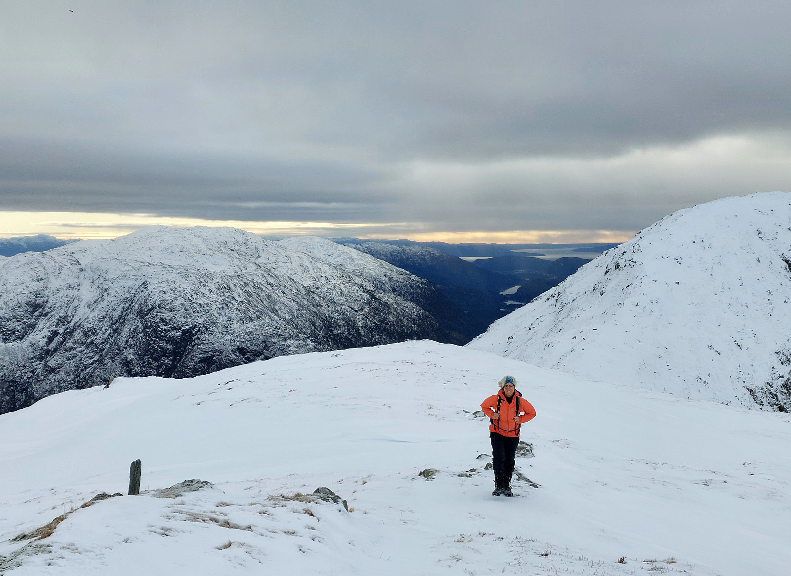
Knappen
- Datum:
- 22.02.2025
- Tourcharakter:
- Bergtour
- Tourlänge:
- 1:30h
- Entfernung:
- 5,3km
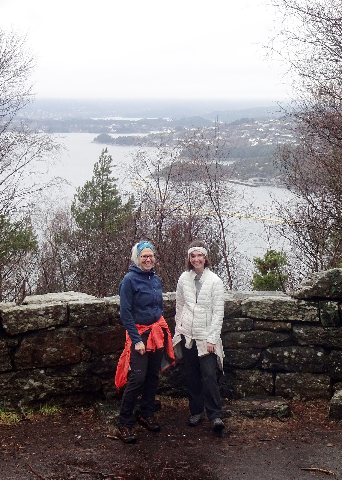 Just stretching our legs a little on Knappen...
Selected photos are available as Google photo album .
See also the related FB-page Hiking around Bergen, Norway .
Just stretching our legs a little on Knappen...
Selected photos are available as Google photo album .
See also the related FB-page Hiking around Bergen, Norway .
Nice round on Herdla
- Datum:
- 16.02.2025
- Tourcharakter:
- Wanderung
- Tourlänge:
- 2:30h
- Entfernung:
- 7,7km
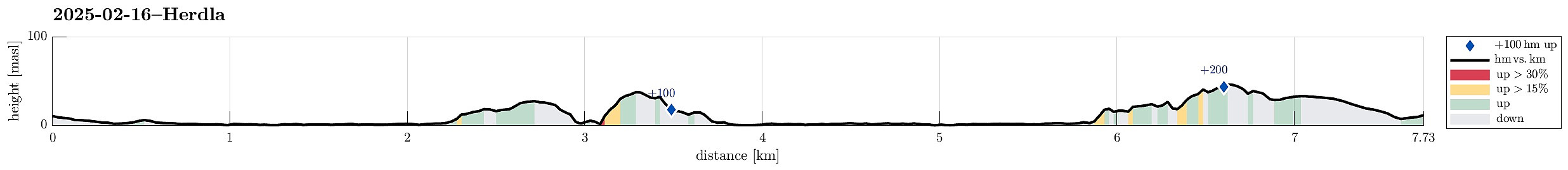 With yet another sunny day on the horizon, we thought that visiting Herdla (after a long time again) would be nice. We thus drove across Askøy and parked near the church of Herdla. We then walked along Herdlevegen to get first to Valen. After following the "inner" shoreline (to Herdlevågen), we followed a historic access road up Småkalvsøyna, exploring some of the still present WWII positions there. From the southeastern "top" of Småkalvsøyna, we then aimed directly at Storakalvsøyna, right in the east of Småkalvsøyna. This brought us to the southeastern end of Paddehola, offering some nice views from there. We also crossed over the south end of this isthmus, enjoying some additional nice views also from there. From there, we then found a reasonable way up >>>
Kannikahaugen from Bildøybakken
- Datum:
- 15.02.2025
- Tourcharakter:
- Wanderung
- Tourlänge:
- 5:00h
- Entfernung:
- 12,0km
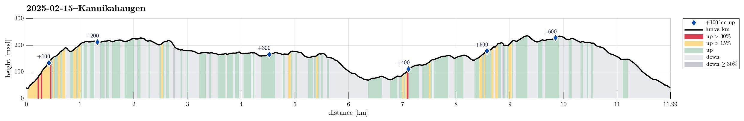 With a really nice weather forecast, we just wished to use the good weather for a nice walk. The idea was to start at Bildøyfjellet, north of Liatårnet on Sotra, and then hike a (squished) round from there (without any plan to actually ascend to Pyttane nor Liatårnet). We parked right next to Bildøybakken, not far from the corner, where one can also drive to Liaskjeret. Instead of using the access road towards the dam of Bildøyvatnet, we aimed at Bildøyfjellet directly (and without a trail). Given the below freezing temperatures, we found the conditions just right for such an off-trail ascent. Within not too long, we then arrived at Bildøykletten (and at the trail, there). We then followed the trail southwards (via Steinane and Vardafjellet). Before descending to Fjellfestningen, >>>
Hananipa
- Datum:
- 09.02.2025
- Tourcharakter:
- Wanderung
- Tourlänge:
- 3:00h
- Entfernung:
- 6,5km
 We expected a nice day and tought that Hananipa would be a nice goal. In fact, we tought that making a nice round, including Raudnipa and/or Trollabotsvarden, would be a good idea. We drove out of Bergen into the direction of Voss and left road E16 at Trengereid to drive up to Nordre Skulstad. There, we parked and started our hike by heading towards Geitshushaugen, first, and then further up to Åsen, before connecting to Brunane. After following Brunane all the way up, we then continued up to Hananipa via its western ridge. Already at home, we had talked about the slightly steep section from Hananipa down to Sauaskaret; when then stepping towards this section, we concluded that we did not feel safe enough (with all the snow etc.). We thus turned around and headed back down the western >>>
Hausdalshorgi via Edne from Hausdalen
- Datum:
- 01.02.2025
- Tourcharakter:
- Wanderung
- Tourlänge:
- 5:00h
- Entfernung:
- 10,8km
 On the map, we had started wondering whether it should not be alright to ascend to Hausdalshorgi from Hausdalen. With some over-optimistic hopes for some sun, we headed into Hausdalen and parked at the very end of the road, where we often would start to hike into Brekkedalen. The idea was to walk a short stretch further up Hausdalen, before then aiming at a ridge in the south of Hausdalshorgi with the name of Edne on it on the map. East of Langhaugen, where a stream comes down from Hausdalshorgi, we then left the main trail, which leads further into Hausdalen, seeing where it would be best to get up to the targeted ridge. After crossing the stream, we saw with some positive surprise that quite obviously this place was used to get higher up the hillside long before us, already (while no >>>
