Arkiv - dato
Arkiv - aktivitet
-
Annen tur (1)
- Kajakkpadling (1)
-
Annen vintertur (4)
- Trugetur (4)
- Fottur (740)
-
Skitur (4)
- Fjellskitur (4)
-
Sykkeltur (137)
- Blandet sykling (51)
- Gatesykling (9)
Arkiv - Etter geografi
"Peakbookvenner"


Lister jeg samler etter
-
Bergen ≥ 50m pf. og ≥ 100 m.o.h.
(87/89)
 97%
97% -
Most dominating tops of the Bergen peninsula
(68/75)
90%
-
Utvalgte topper og turmål i Bergen
(316/350)
90%
-
Alle topper i Bergen
(357/398)
89%
-
Opptur Bergen
(100/113)
88%
-
De syv fjell rundt Bergen
(6/7)
85%
-
Sund ≥ 50m pf.
(14/18)
77%
-
Os ≥ 50m pf.
(25/34)
73%
-
Søyler (fastmerker) i Bergen
(68/100)
68%
-
Fjell ≥ 50m pf.
(21/32)
65%

Løvstakken and Løvstien
- Dato:
- 30.12.2024
- Turtype:
- Fottur
- Turlengde:
- 3:00t
- Distanse:
- 8,8km
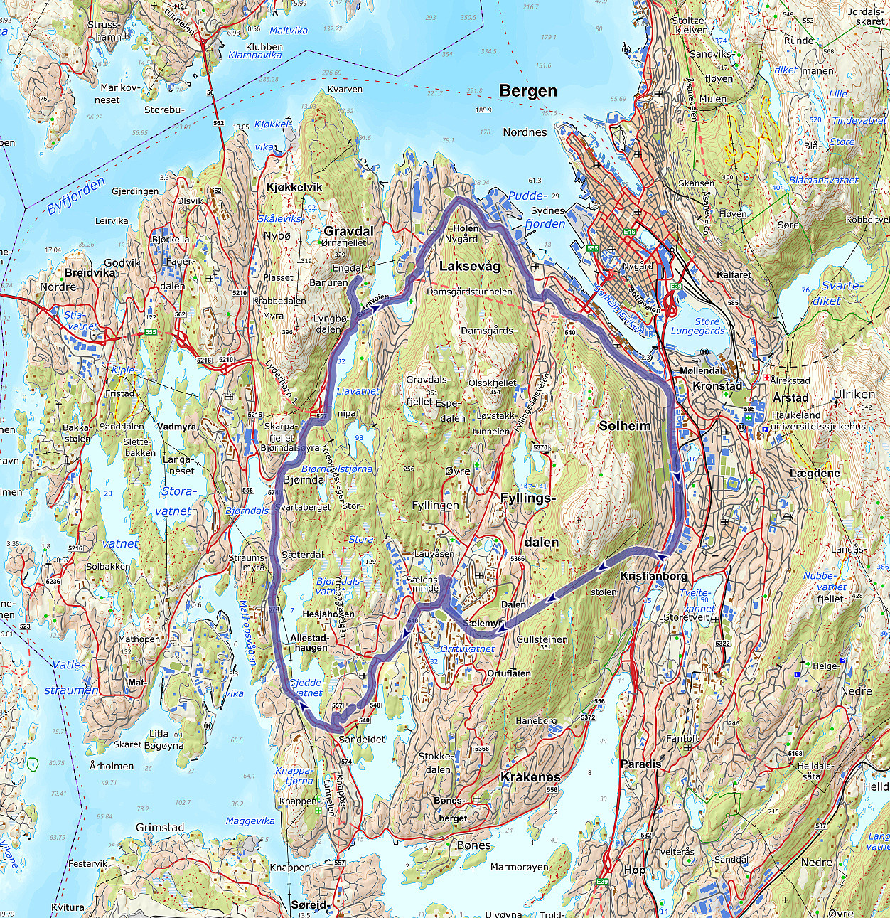
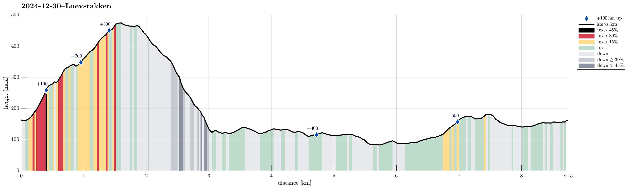 Together with friends, we had decided to use the afternoon for a short hike in the local area. We parked in the east of Litlavatnet in the northeast of Fyllingsdalen and headed up to Løvstakken following the main trail from the parking place. From the top of Løvstakken, we then descended towards the southeast using a minor trail a bit further east than the main trail in the south of Løvstakken. This brought us down to Løvstien, which we then followed (in northern direction) to complete a round back to Fyllingsdalen. Our timing was just right to cross over Løvstakken without any need for head lights -- down on Løvstien, we then took advantage of the installed lights. At the end of the hike, it started to snow, adding a nice touch to the overall experience! :-)
Selected photos are available >>>
Together with friends, we had decided to use the afternoon for a short hike in the local area. We parked in the east of Litlavatnet in the northeast of Fyllingsdalen and headed up to Løvstakken following the main trail from the parking place. From the top of Løvstakken, we then descended towards the southeast using a minor trail a bit further east than the main trail in the south of Løvstakken. This brought us down to Løvstien, which we then followed (in northern direction) to complete a round back to Fyllingsdalen. Our timing was just right to cross over Løvstakken without any need for head lights -- down on Løvstien, we then took advantage of the installed lights. At the end of the hike, it started to snow, adding a nice touch to the overall experience! :-)
Selected photos are available >>>
Straumsåsen
- Dato:
- 29.12.2024
- Turtype:
- Spasertur
- Turlengde:
- 1:30t
- Distanse:
- 6,3km
 We just wished to get some fresh air and thus headed for a short walk in the neighborhood.
See also the related FB-page Hiking around Bergen, Norway .
We just wished to get some fresh air and thus headed for a short walk in the neighborhood.
See also the related FB-page Hiking around Bergen, Norway .
Kyrkjenibben etc.
- Dato:
- 23.12.2024
- Turtype:
- Fottur
- Turlengde:
- 3:00t
- Distanse:
- 8,4km
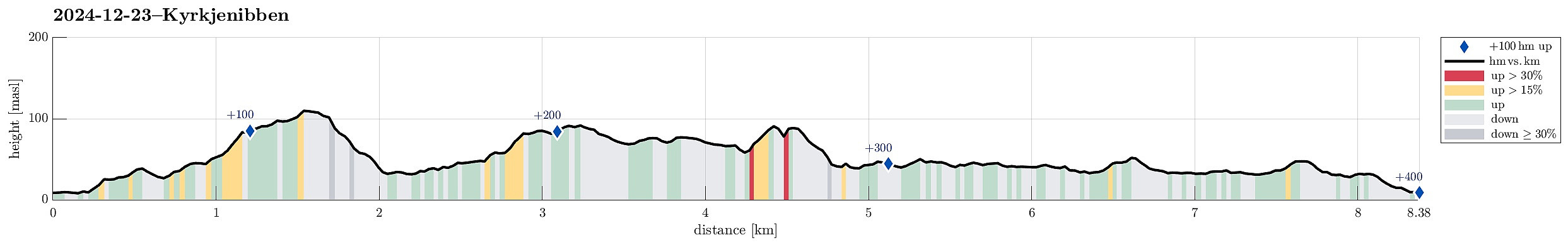 We expected the higher tops to be covered with clouds and thus decided to instead head towards the coast for a simple hike. We knew that one should be able to find a historic connection between Morland and Fjell, kyrkjevegen, which apparently was used by the people of Morland to get to the church in Fjell previously. We started near the church in Fjell and followed kyrkjevegen until we came to the south end of Eidesvatnet. Instead of following kyrkjevegen further northwards from there, we had already decided that we wished to include a detour to Gardafjellet a bit further west. Following a trail around Kvernhaugen (around the south of Liavatnet) brought us to the trail up to Gardafjellet (in northwestern direction). At Gardafjellet we enjoyed some nice views, before continuing -- then >>>
Nice round around Korsneset
- Dato:
- 08.12.2024
- Turtype:
- Fottur
- Turlengde:
- 2:30t
- Distanse:
- 5,5km
 The weather was looking good for this Sunday and so we aimed at getting some fresh air around our heads. We headed via Fana to Korsneset and parked at the parking place right at the entry to the military area. Our first goal was Hendershaugen in the south of the road. To get there, we first walked the road back a few meters, before then heading towards the top of Hendershaugen along the outer rim of the military area. Even though Hendershaugen is not very high, it's still nice to get up there and enjoy some nice views. From Henderhaugen, we then headed northwards. More or less right where we stepped out of the forest and onto Korsnesvegen, we decided to continue northwards via the eastern heights of Korsneset (instead of walking back to the parking place). Within a few minutes, we were >>>
Wet cycling around Damsgårdsfjellet
- Dato:
- 01.12.2024
- Turtype:
- Gatesykling
- Turlengde:
- 1:30t
- Distanse:
- 23,2km
 The indeed very wet Sunday did not really invite to a hike. Making a bike-trip, however, seemed just OK to get some fresh air. Starting at Varden, I first biked along Bjørgeveien into the direction of Loddefjord. Between Svartaberget in the southeast and Skarkafjellet in the northwest, I then turned into the direction of Laksevåg (towards the northeast). After cycling along Liavatnet, I was in the mood to double-check whether there wasn't a way to connect from Nordre Banuren to Gravdalslien with the bike (my memory was that there certainly is no way to drive this connection with a car, though). After cycling up to Nordre Banuren, I got the very clear impression that crossing over to Gravdalslien with the bike was neither possible (not without carrying the bike etc.). I thus biked back >>>
