Archive - Date
Archive - Activity
-
Bike trip (137)
- Bike trip - mixed (51)
- Bike trip - road (9)
-
Other trip (1)
- Kayaking (1)
-
Other winter trip (4)
- Snowshoe trip (4)
- Ski trip (4)
- Trip by foot (740)
Archive - Geography
Peakbook-Friends


Collected lists
-
Bergen ≥ 50m pf. og ≥ 100 m.o.h.
(87/89)
 97%
97% -
Most dominating tops of the Bergen peninsula
(68/75)
90%
-
Utvalgte topper og turmål i Bergen
(316/350)
90%
-
Alle topper i Bergen
(357/398)
89%
-
Opptur Bergen
(100/113)
88%
-
De syv fjell rundt Bergen
(6/7)
85%
-
Sund ≥ 50m pf.
(14/18)
77%
-
Os ≥ 50m pf.
(25/34)
73%
-
Søyler (fastmerker) i Bergen
(68/100)
68%
-
Fjell ≥ 50m pf.
(21/32)
65%

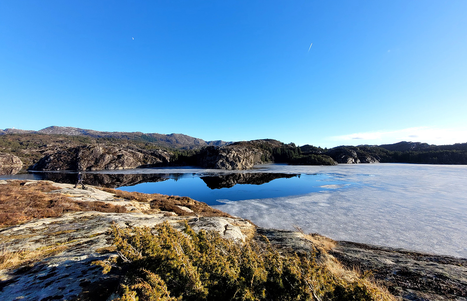
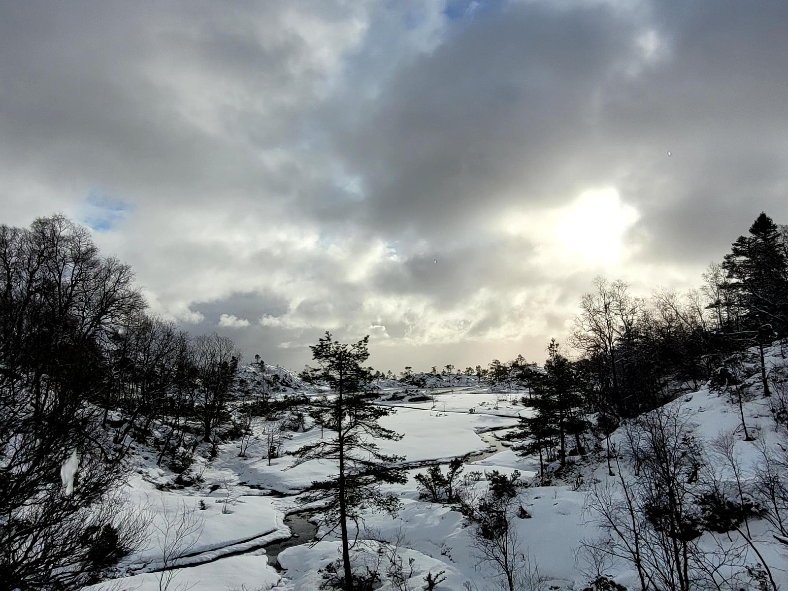
Exploring Lyreneset on our bike-ride to Bergen
- Date:
- 24.02.2024
- Characteristic:
- Bike trip
- Duration:
- 2:00h
- Distance:
- 17.2km
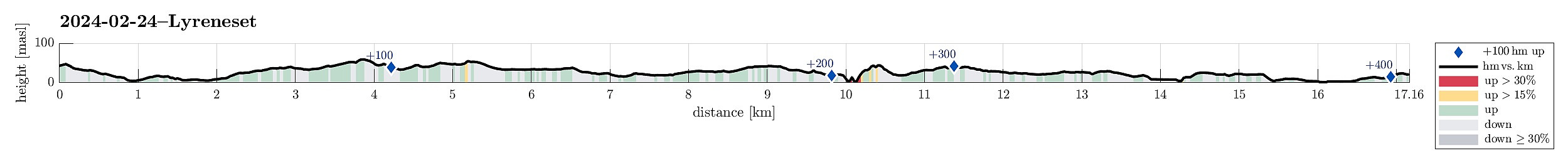 We biked first along Bjørgeveien into the direction of Loddefjord, then around Bjørndalstjørna further northwards to Liavatnet. After cycling around Lyngbøvatnet, we made a detour to Lyreneset. There, we explored the cape by foot, also enjoying some nice views across Byfjorden. Thereafter, we continued our bike-ride towards Bergen. This bike-excursion came to an unplanned end due to a flat tire, requiring a change to public transport from there on.
Selected photos are available as Google photo album .
See also the related FB-page Hiking around Bergen, Norway .
We biked first along Bjørgeveien into the direction of Loddefjord, then around Bjørndalstjørna further northwards to Liavatnet. After cycling around Lyngbøvatnet, we made a detour to Lyreneset. There, we explored the cape by foot, also enjoying some nice views across Byfjorden. Thereafter, we continued our bike-ride towards Bergen. This bike-excursion came to an unplanned end due to a flat tire, requiring a change to public transport from there on.
Selected photos are available as Google photo album .
See also the related FB-page Hiking around Bergen, Norway .
Ørnafjellet and Austre Høghaugen
- Date:
- 17.02.2024
- Characteristic:
- Hike
- Duration:
- 3:30h
- Distance:
- 7.9km
 We expected some nice sun and decided to enjoy the day with an exploration of a part of Sotra that we had not visited before. We drove the car to Sotra and there to Fjell. South of Fjell, along Søre Fjellavegen and right next to Gardstjørna, we parked next to the road and started our hike, walking down a simple road towards Fjellspollen. Still on this road, we conveniently crossed over the waters, that spring down from Bosvatnet to Litlepollen, using the road-bridge. Studying the map at home had suggested that starting our ascent up to Ørnafjellet would be possible right from the road in the north of Litlepollen. Once there, however, we saw that the hill-side appeared a bit steeper than originally expected. Still, we could make it up to the heights in the north of Litlepollen without >>>
Kjerringafjellet from Heggland and Borgafjellet
- Date:
- 04.02.2024
- Characteristic:
- Hike
- Duration:
- 4:00h
- Distance:
- 6.9km
 Thinking about snow at higher elevation, we made a plan for a hike that would not lead us so much up, altogether. Still, we aimed at something interesting: Hiking towards (not all the way up to, though) Møsnuken from Heggland. During an earlier hike, a sign was seen that pointed towards Møsnuken at Heggland (near Hegglandsdalsvegen in the northeast of Osøyro). The map shows an approximate trail (leading up to Hegglandstjørna), but no details are to be seen. Exploiting the fact that we came with two cars, we parked one near the planned end of the hike (below Borgafjellet) and then took the other one further along Hegglandsdalsvegen to park near Heggland. Indeed we quickly found the trail-head, again, at Heggland and started the ascent from there. The southeastern side of Møsnuken, >>>
Pyttane in windy weather
- Date:
- 03.02.2024
- Characteristic:
- Hillwalk
- Duration:
- 1:30h
- Distance:
- 6.7km
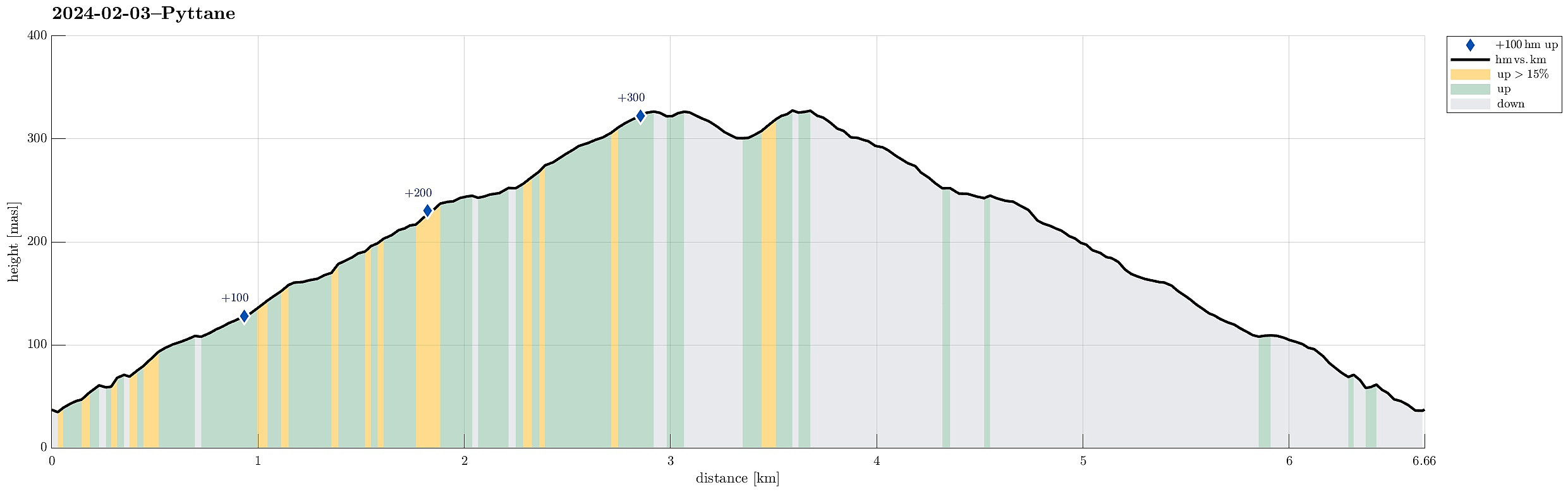 With quite a bit of weather outside, we decided to "just" go up and down Pyttane on Sotra. We took the car to Ekrhovdvegen in the very east of Sotra and parked near Nordre Stølen, where the service road up to Pyttane starts. We then walked up to the radar stations, experiencing significant weather on the top (strong winds, some precipitation). While it was nice to get out into the fresh air, we still did not feel like staying up there "in the elements" for any prolonged time, thus walking back down more or less immediately, again. All in all, this walk up to Pyttane is always nice (and easy), lending itself well to getting some fresh air without an all-too-long trip.
Selected photos are available as Google photo album .
See also the related FB-page Hiking around Bergen, Norway .
Web page WestCoastPeaks.com provides useful information about Liatårnet
and also Petter Bjørstad has a >>>
With quite a bit of weather outside, we decided to "just" go up and down Pyttane on Sotra. We took the car to Ekrhovdvegen in the very east of Sotra and parked near Nordre Stølen, where the service road up to Pyttane starts. We then walked up to the radar stations, experiencing significant weather on the top (strong winds, some precipitation). While it was nice to get out into the fresh air, we still did not feel like staying up there "in the elements" for any prolonged time, thus walking back down more or less immediately, again. All in all, this walk up to Pyttane is always nice (and easy), lending itself well to getting some fresh air without an all-too-long trip.
Selected photos are available as Google photo album .
See also the related FB-page Hiking around Bergen, Norway .
Web page WestCoastPeaks.com provides useful information about Liatårnet
and also Petter Bjørstad has a >>>
