Archiv - Nach Datum
Archiv - Nach Aktivität
-
Andere Tour (1)
- Kayaking (1)
-
Andere Wintertour (4)
- Schneeschuhtour (4)
-
Fahrradtour (137)
- Fahrradtour Straße (9)
- Fahrradtour gemischt (51)
-
Fußtour (740)
- Bergtour (363)
- Jogging (18)
- Spaziergang (89)
- Wanderung (270)
-
Skitour (4)
- Tourenskilauf (4)
Archiv - Nach Geografie
Peakbookfreunde


Gesammelte Listen
-
Bergen ≥ 50m pf. og ≥ 100 m.o.h.
(87/89)
 97%
97% -
Most dominating tops of the Bergen peninsula
(68/75)
90%
-
Utvalgte topper og turmål i Bergen
(316/350)
90%
-
Alle topper i Bergen
(357/398)
89%
-
Opptur Bergen
(100/113)
88%
-
De syv fjell rundt Bergen
(6/7)
85%
-
Sund ≥ 50m pf.
(14/18)
77%
-
Os ≥ 50m pf.
(25/34)
73%
-
Søyler (fastmerker) i Bergen
(68/100)
68%
-
Fjell ≥ 50m pf.
(21/32)
65%

Longer walk to Rohrhaus and back
- Datum:
- 27.12.2023
- Tourcharakter:
- Wanderung
- Tourlänge:
- 4:00h
- Entfernung:
- 15,0km
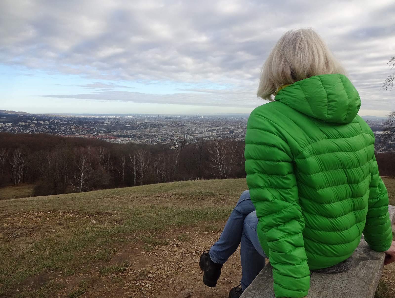 On this day, we thought that it was a nice idea to make an excursion to the Lainzer Tiergarten on the other side of the Wien-valley. We first headed towards Dehnepark, then down to Linzer Straße. After walking down Bergmillergasse for a short stretch, we used Brauhausbrücke to get over the Wien stream towards the other side. There, it was then only a few meters to get to Nikolaitor (and through it into Lainzer Tiergarten). Once in the park, we first passed by Nikolaikapelle, reading a bit about its very long history! Then, we started walking uphill along the Hackenbergweg (into the direction of Hagenberg). After visiting Hagenberg, just briefly, we continued, heading for a nice pace called Wiener Blick (for its nice view across Wien, of course). We then continued to Rohrhaus, before >>>
Excursion to Heuberg
- Datum:
- 25.12.2023
- Tourcharakter:
- Wanderung
- Tourlänge:
- 3:00h
- Entfernung:
- 10,4km
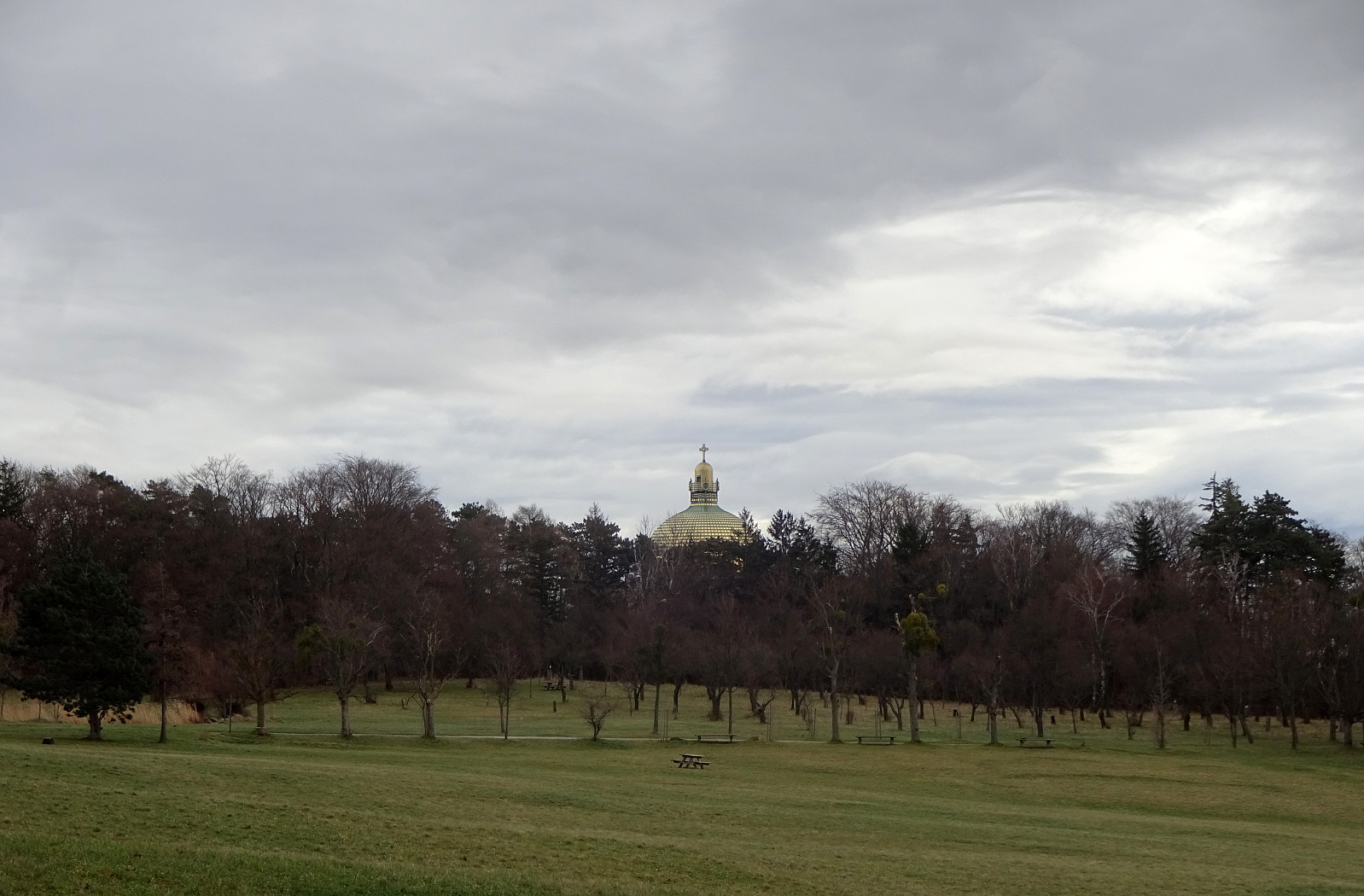 I wished to get some fresh air and so headed out for a walk. First, I headed towards Steinhof, walking across the green area towards the old fire station in the north of Steinhof. I then continued "in parallel" to Savoyenstraße, passing by the Schloss at Wilheminenberg soon after. Turning left, a bit further down, again, I stepped down Eselstiege (into the direction of Heuberg). On the other side, I followed two streets to get up to Röntgengasse. Walking up Röntgengasse, I got back into the forest (in the southeast of Heuberg). Following some minor trails, I quickly made it up "to the top" of Heuberg. From Heuberg, I then walked along the heights to Jubiläumswarte. From there, I "improvised" through Gemeindewald to get back. Crossing Loiblstraße in >>>
Round via Satzberg and Jubiläumswarte
- Datum:
- 22.12.2023
- Tourcharakter:
- Wanderung
- Tourlänge:
- 2:00h
- Entfernung:
- 6,3km
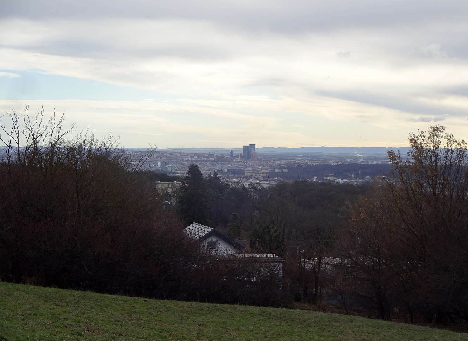 We wanted to get some fresh air and thus headed towards Dehnepark, first. After briefly walking upwards "in the bottom" of Dehnepark, passing by the little lake (on its western side), we crossed over Rosentalgasse to start an ascent towards Satzberg. A bit further up, we also crossed Steinböckengasse. From there, it was then basically further northwards to get all the way up to Satzberg. While one can enjoy some nice views across Wien from the ascent, the actual top of Satzberg is not exciting (and also without views, due to all the trees). From Satzberg, we then transitioned over to Jubiläumswarte (in the north, northeast of Satzberg). Then, it was mostly to walk back, first towards Steinhof.
Selected photos are available as Google photo album .
See also the related FB-page Hiking around Bergen, Norway .
We wanted to get some fresh air and thus headed towards Dehnepark, first. After briefly walking upwards "in the bottom" of Dehnepark, passing by the little lake (on its western side), we crossed over Rosentalgasse to start an ascent towards Satzberg. A bit further up, we also crossed Steinböckengasse. From there, it was then basically further northwards to get all the way up to Satzberg. While one can enjoy some nice views across Wien from the ascent, the actual top of Satzberg is not exciting (and also without views, due to all the trees). From Satzberg, we then transitioned over to Jubiläumswarte (in the north, northeast of Satzberg). Then, it was mostly to walk back, first towards Steinhof.
Selected photos are available as Google photo album .
See also the related FB-page Hiking around Bergen, Norway .
Eikelisteinen on Eikelifjellet
- Datum:
- 25.11.2023
- Tourcharakter:
- Fahrradtour gemischt
- Tourlänge:
- 3:00h
- Entfernung:
- 8,5km
 We started on our eBikes, first riding north into Fyllingsdalen, and then to Spelhaugen. At the northern end of Spelhaugen, we left our bikes behind, and continued on foot. Instead of following the main route (up the gravel road, into the direction of Tennebekk), we turned right "at once" (into the direction of Lurane in the northeast of Spelhaugen). Even there, we decided that we were up to choosing a quite steep route up (without a trail). Quite soon, we had made some height meters and, turning around, we could enjoy some nice views across Spelhaugen. Once on the heights, we traversed over to the southern end of Eikelia. Instead of following the more usual route (first northwards on the western side of Eikelifjellet's western cliff), we went around the wet area in the south >>>
Lyderhorn from Loddefjord
- Datum:
- 18.11.2023
- Tourcharakter:
- Fahrradtour gemischt
- Tourlänge:
- 2:00h
- Entfernung:
- 15,0km
 To get some fresh air on this Saturday, we took our eBikes and biked to Loddefjord. In the west of Skarpafjellet, we took a side road up to the transformer station (west of Grøvledalen). From there we followed the trail up to the saddle in the north of Skarpafjellet, following the trail towards Lyderhorn from there. For the ascent to Lyderhorn, we chose the route via Små Lyderhorn, while we then descended along the trail a bit further in the east. Once down from Lyderhorn, again, we basically followed the same trail back to our bikes that we had taken up, first. Always nice to make a trip to Lyderhorn! :-)
Selected photos are available as Google photo album .
See also the related FB-page Hiking around Bergen, Norway .
Petter Bjørstad has a useful page about Lyderhorn and also web page WestCoastPeaks.com provides useful information about Lyderhorn and Ørnafjellet .
To get some fresh air on this Saturday, we took our eBikes and biked to Loddefjord. In the west of Skarpafjellet, we took a side road up to the transformer station (west of Grøvledalen). From there we followed the trail up to the saddle in the north of Skarpafjellet, following the trail towards Lyderhorn from there. For the ascent to Lyderhorn, we chose the route via Små Lyderhorn, while we then descended along the trail a bit further in the east. Once down from Lyderhorn, again, we basically followed the same trail back to our bikes that we had taken up, first. Always nice to make a trip to Lyderhorn! :-)
Selected photos are available as Google photo album .
See also the related FB-page Hiking around Bergen, Norway .
Petter Bjørstad has a useful page about Lyderhorn and also web page WestCoastPeaks.com provides useful information about Lyderhorn and Ørnafjellet .
Exploring the north of Maria Island
- Datum:
- 09.11.2023
- Tourcharakter:
- Fahrradtour gemischt
- Tourlänge:
- 6:00h
- Entfernung:
- 38,3km
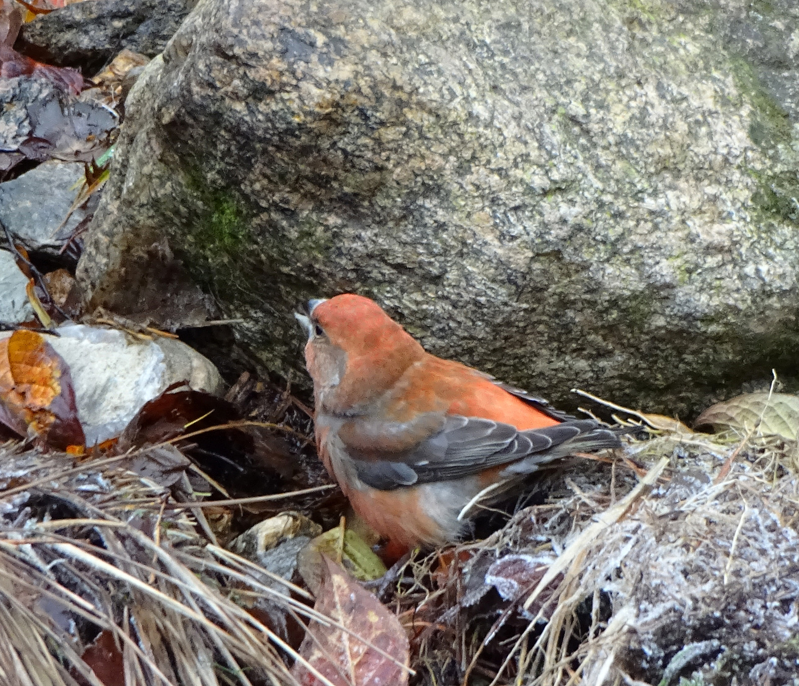
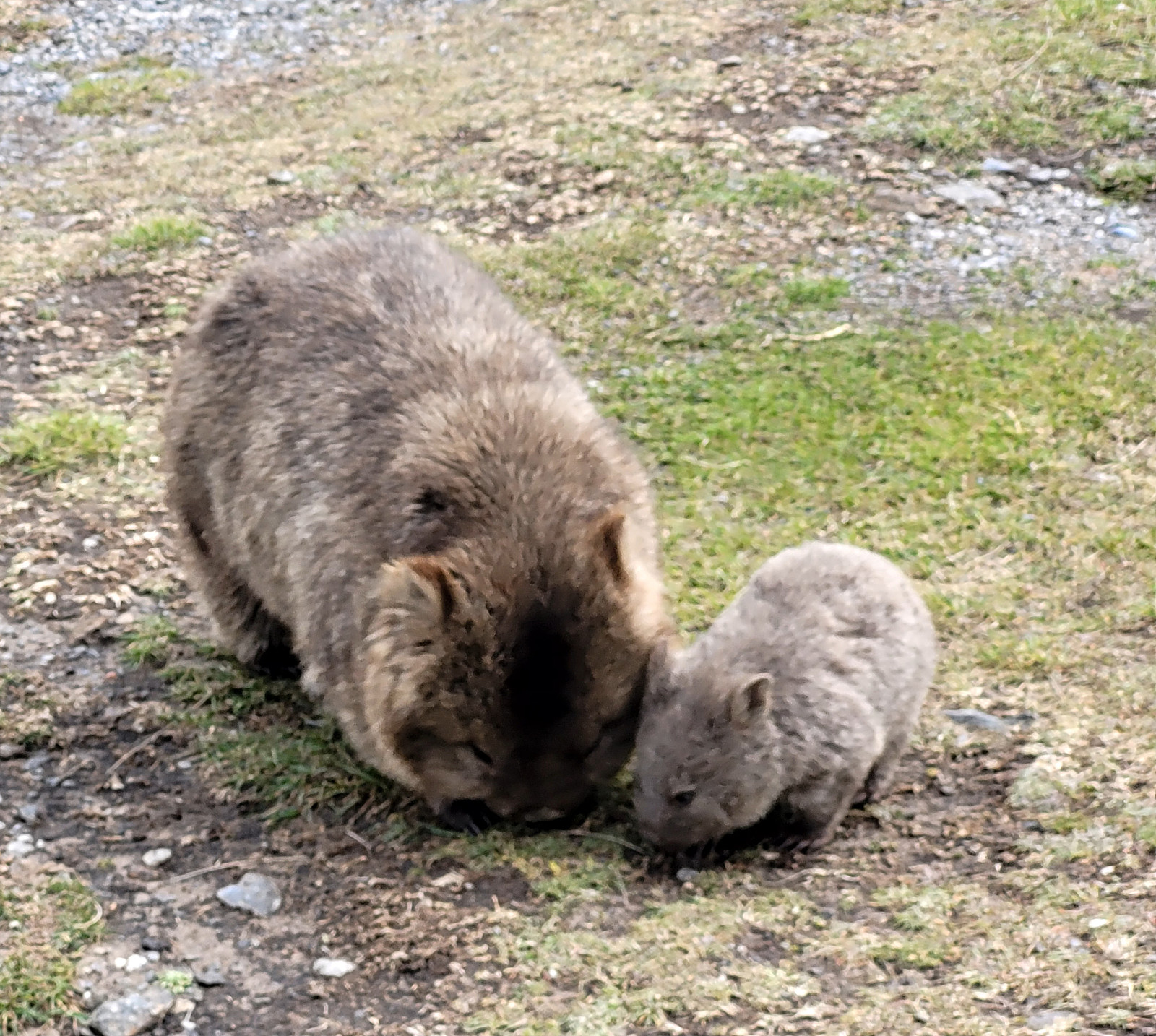 With one more day "to go", we decided to also include a trip to Maria Island, even though it not really was en route to Hobart. We stayed overnight in Triabunna, just a walking distance from the ferry quay. The next morning, we took the first ferry to Maria Island. Even though we had not booked any bikes in advance, we still hoped that we could get two bikes for the day anyway. Thus, after a mandatory short introduction to Maria Island, right after our arrival, we first headed for the bike rental in Darlington. Luckily, they weren't yet out of bikes, renting two of them out to us. :-) And this indeed was very nice -- Maria Island has quite a bit to offer and if one only has one day, then bridging distances between sights is definitely much more convenient per bike. After making >>>
Cape Raoul
- Datum:
- 07.11.2023
- Tourcharakter:
- Wanderung
- Tourlänge:
- 5:00h
- Entfernung:
- 17,9km
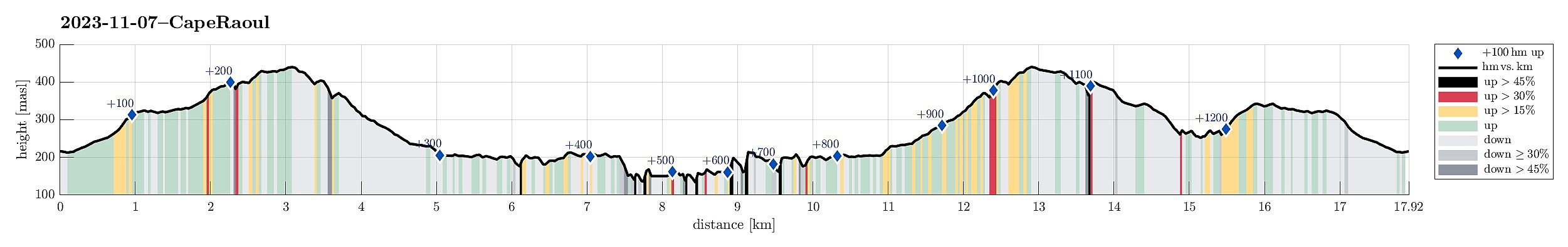 Plan two of our visit to the Tasman Peninsula was to hike out to Cape Raoul. We thus "switched over" from Fortescue Bay to Nubeena in the west of Port Arthur, and following the signs towards Cape Raoul from there, parking right next to the trail head, at about the end of the road, south of Stormlea. The very well marked trail to Cape Raoul leads first (gently) up (through the forest) to a nice vista point, Cape Raoul Lookout, high above the tall western cliffs of Mount Raoul. From there, it's then southwards (parallel to the cliffs) into the direction of Cape Raoul. We again had luck with the weather and enjoyed walking out there very much. Before actually getting to the southern-most tip of Cape Raoul, we passed by a particularly nice place ("The Gap"), where one (a) >>>
Cape Hauy
- Datum:
- 06.11.2023
- Tourcharakter:
- Wanderung
- Tourlänge:
- 3:30h
- Entfernung:
- 10,9km
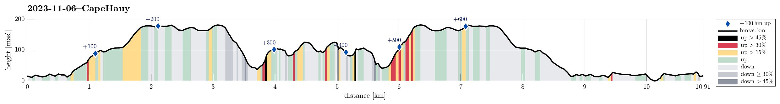 When doing the rough overall-planning of our trip through Tasmania, we had put down two major goals: the "Wild West" of Tasmania as well as the south-east (with either Bruny Island and/or the Tasman Peninsula). While changing over from the west to the southeast, we then decided to focus on the Tasman Peninsula (instead of trying too much in only a few days). Connecting to the Tasman Peninsula was easy and straight-forward from Hobart. We had seen that one can do several, also multiple days long hikes there, so we had to choose. First, we thought that we could explore Cape Hauy, starting from Fortescue Bay. To get there, we had to navigate a several kilometers long forest road (on gravel). While this was not 100% pleasant, it still was fully OK and we arrived in Fortescue Bay >>>
Short walk to Donaghys Hill
- Datum:
- 05.11.2023
- Tourcharakter:
- Bergtour
- Tourlänge:
- 1:00h
- Entfernung:
- 2,2km
 While we thought that we not really had sufficient time for an extended hike, this day, we still wished to see at least something along our drive through the Central Highlands. To do so, we followed a sign that suggested a short walk to Donaghys Hill in order to appreciate some nice views from its top. Parking right next to the highway, we first walked along a forest road, before turning right and into the forest along a regular trail. Not for the first time, and not for the last time in Tasmania, neither, we got very impressed by the very tall trees (and the jungle underneath them). Not far along this trail, we then stepped out of the forest and up onto Donaghys Hill. And indeed, it is true that this little hill offers surprisingly nice views, to the far (for ex., to Frenchmans Cap) as >>>
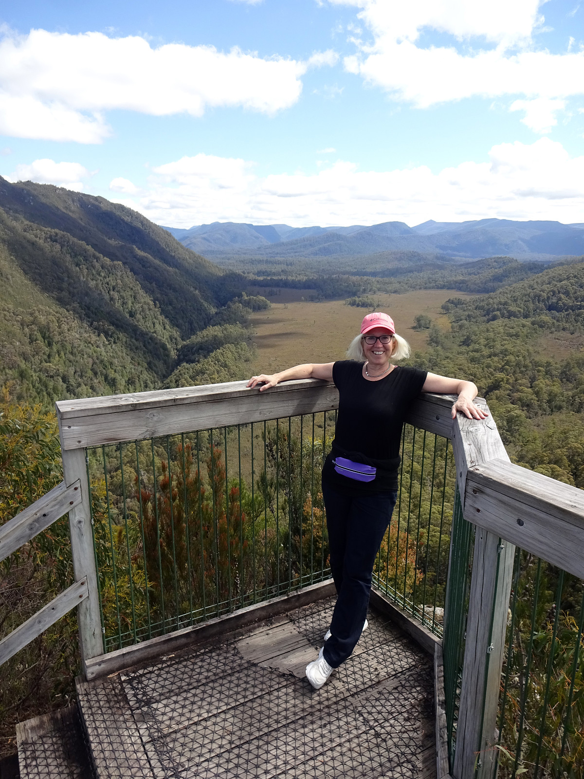
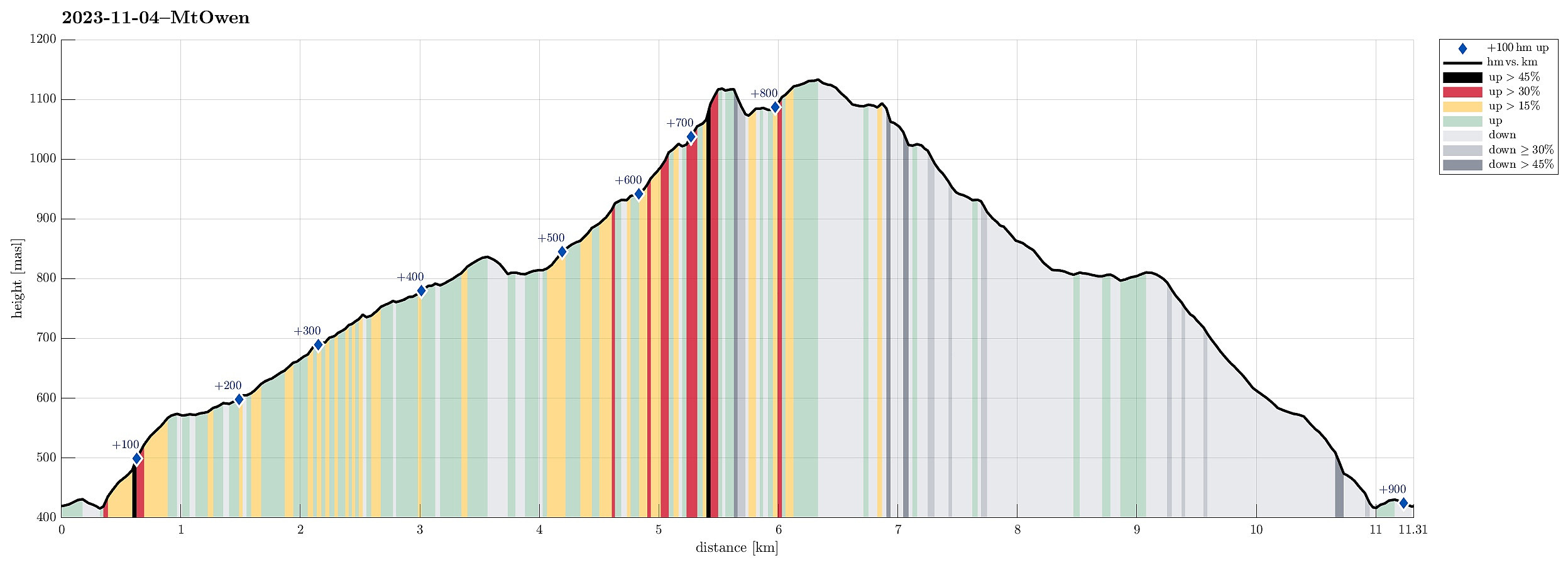
Unplanned Mount Owen
- Datum:
- 04.11.2023
- Tourcharakter:
- Wanderung
- Tourlänge:
- 3:00h
- Entfernung:
- 11,3km
 We had used most of the day to participate in a boat cruise on Macquarie Harbour (from Strahan), seeing the feared entry point (Hells Gates), the Gordon river (on the far, southeastern end of Macquarie Harbour) and the jungle around it, as well as Sarah Island (with all its dark history as a penal station). After all of this, we had no more plan than just driving a bit into the direction of the Central Highlands. Driving out of Strahan, we first headed towards Queenstown, which is strongly characterized by previous and current mining operations. This place did not appear inviting to us at all and we continued further eastwards (up the Lyell Highway Pass, first). As soon as we got close to the highest point on that saddle, we read a sign that hinted upon the opportunity to see a nice waterfall >>>
