Archiv - Nach Datum
Archiv - Nach Aktivität
-
Andere Tour (1)
- Kayaking (1)
-
Andere Wintertour (4)
- Schneeschuhtour (4)
-
Fahrradtour (137)
- Fahrradtour Straße (9)
- Fahrradtour gemischt (51)
-
Fußtour (740)
- Bergtour (363)
- Jogging (18)
- Spaziergang (89)
- Wanderung (270)
-
Skitour (4)
- Tourenskilauf (4)
Archiv - Nach Geografie
Peakbookfreunde


Gesammelte Listen
-
Bergen ≥ 50m pf. og ≥ 100 m.o.h.
(87/89)
 97%
97% -
Most dominating tops of the Bergen peninsula
(68/75)
90%
-
Utvalgte topper og turmål i Bergen
(316/350)
90%
-
Alle topper i Bergen
(357/398)
89%
-
Opptur Bergen
(100/113)
88%
-
De syv fjell rundt Bergen
(6/7)
85%
-
Sund ≥ 50m pf.
(14/18)
77%
-
Os ≥ 50m pf.
(25/34)
73%
-
Søyler (fastmerker) i Bergen
(68/100)
68%
-
Fjell ≥ 50m pf.
(21/32)
65%

Lyderhorn from Loddefjord
- Datum:
- 11.09.2022
- Tourcharakter:
- Wanderung
- Tourlänge:
- 1:30h
- Entfernung:
- 4,2km
 With only limited time available, we decided to "just" make a short hike to Lyderhorn, exploring a new "corner" of this rather well-known mountain. We started biking to Loddefjord. We then continued up a side road of Lyderhornsveien, which services the power facility a few meters above Loddefjord, right below Skarpafjellet. From there, we first followed the trail that leads up to Grøvledalen, but decided to follow a slightly different route up, first. Soon later, we reconnected with the trail between Skarpafjellet and Lyderhorn. From there, it was then basically up and down Lyderhorn, mostly following trails. On the way back, we then descended towards Loddefjord through Grøvledalen. Nice to explore new routes, even on an often visited mountain like Lyderhorn! :-)
Gaustadfjellet, Litlafjellet, Bårafjellet, Øyjordsfjellet
- Datum:
- 04.09.2022
- Tourcharakter:
- Wanderung
- Tourlänge:
- 6:30h
- Entfernung:
- 11,4km
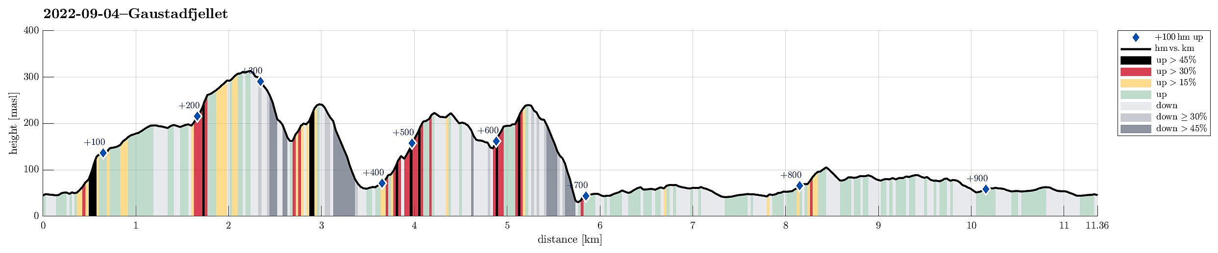 Looking forward to a nice day, we decided to pay Gaustadfjellet on Holsnøy a visit. To get there, we crossed Krossnessundet right after driving over Nordhordlandsbrua, north of Bergen. Then, we followed road 5310 northwestwards, kind of parallel to Radfjorden on our right side. Since we wished to start our hike from the southeast, traversing all of Gaustadfjellet (and further), we first needed to find a proper parking place along Ådlandsvegen. After a bit of back and forth, we managed to park properly along this rather narrow road. We then followed a not really well visible trail to the southern ridge of Gaustadfjellet (Storhøyden). From there, then, we could use a nice trail that extends over most of this ridge. It's actually a very nice alternative to the otherwise shorter ascent >>>
Lyshornet from Lysekloster
- Datum:
- 03.09.2022
- Tourcharakter:
- Wanderung
- Tourlänge:
- 2:30h
- Entfernung:
- 7,3km
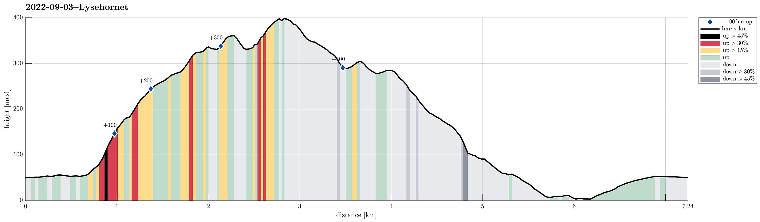 To get some fresh air, we decided to do a simple hike, not far from home: Lyshornet. We parked near Lysekloster and followed the main trail to Lyshornet from there. This lead us up to Lyshornskaret from where a short detour to Vetla Lyshornet was included. After enjoying the day for a moment on Lyshornet, we then started our hike down, following a trail towards the west from the top. This trail leads one down to the service road, which leads up to Ulvvatnet from Lyseklostervegen. Once on this road, it was then to first walk it down, before then following Lyseklostervegen back up to where we had parked. Clearly a nice little round with some nice views from Lyshornet.
Selected photos are available as Google photo album .
See also the related FB-page Hiking around Bergen, Norway .
Petter Bjørstad has a useful page about Lysehornet and also web page WestCoastPeaks.com provides useful information about Lysehornet .
Web page UT.no from the >>>
To get some fresh air, we decided to do a simple hike, not far from home: Lyshornet. We parked near Lysekloster and followed the main trail to Lyshornet from there. This lead us up to Lyshornskaret from where a short detour to Vetla Lyshornet was included. After enjoying the day for a moment on Lyshornet, we then started our hike down, following a trail towards the west from the top. This trail leads one down to the service road, which leads up to Ulvvatnet from Lyseklostervegen. Once on this road, it was then to first walk it down, before then following Lyseklostervegen back up to where we had parked. Clearly a nice little round with some nice views from Lyshornet.
Selected photos are available as Google photo album .
See also the related FB-page Hiking around Bergen, Norway .
Petter Bjørstad has a useful page about Lysehornet and also web page WestCoastPeaks.com provides useful information about Lysehornet .
Web page UT.no from the >>>
