Archiv - Nach Datum
Archiv - Nach Aktivität
-
Andere Tour (1)
- Kayaking (1)
-
Andere Wintertour (4)
- Schneeschuhtour (4)
-
Fahrradtour (137)
- Fahrradtour Straße (9)
- Fahrradtour gemischt (51)
-
Fußtour (740)
- Bergtour (363)
- Jogging (18)
- Spaziergang (89)
- Wanderung (270)
-
Skitour (4)
- Tourenskilauf (4)
Archiv - Nach Geografie
Peakbookfreunde


Gesammelte Listen
-
Bergen ≥ 50m pf. og ≥ 100 m.o.h.
(87/89)
 97%
97% -
Most dominating tops of the Bergen peninsula
(68/75)
90%
-
Utvalgte topper og turmål i Bergen
(316/350)
90%
-
Alle topper i Bergen
(357/398)
89%
-
Opptur Bergen
(100/113)
88%
-
De syv fjell rundt Bergen
(6/7)
85%
-
Sund ≥ 50m pf.
(14/18)
77%
-
Os ≥ 50m pf.
(25/34)
73%
-
Søyler (fastmerker) i Bergen
(68/100)
68%
-
Fjell ≥ 50m pf.
(21/32)
65%

Kanadaskogen from Varden
- Datum:
- 28.05.2022
- Tourcharakter:
- Wanderung
- Tourlänge:
- 1:30h
- Entfernung:
- 4,6km
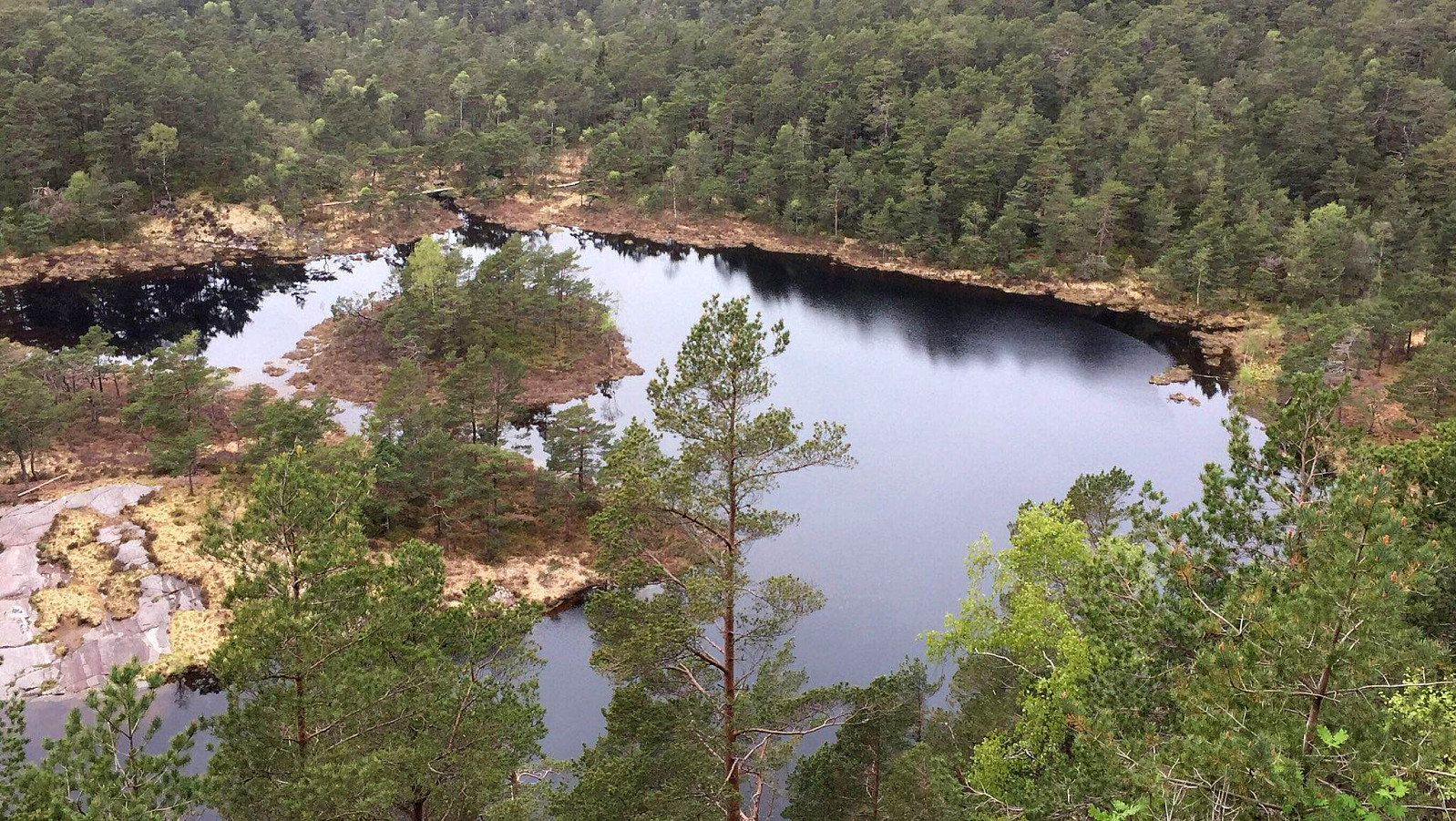
 Walk through Kanadaskogen from Varden, including Hesjaholten. After first passing by Gjeddevatnet at Skaget, we crossed over some minor hills in northern direction, coming close to Bjørndalsvatnet (but not descending all the way down to it, this time). North of Hesjaholten, we then ascended to one of the small cliffs using a narrow gully in southwards direction. We then included also a neighboring cliff (a little further towards the northeast), before heading back into the direction of Varden, including Hesjaholten along the way. It's definitely possible to experience small but nice micro-adventures in Kanadaskogen! :-)
Selected photos are available as Google photo album .
See also the related FB-page Hiking around Bergen, Norway .
Walk through Kanadaskogen from Varden, including Hesjaholten. After first passing by Gjeddevatnet at Skaget, we crossed over some minor hills in northern direction, coming close to Bjørndalsvatnet (but not descending all the way down to it, this time). North of Hesjaholten, we then ascended to one of the small cliffs using a narrow gully in southwards direction. We then included also a neighboring cliff (a little further towards the northeast), before heading back into the direction of Varden, including Hesjaholten along the way. It's definitely possible to experience small but nice micro-adventures in Kanadaskogen! :-)
Selected photos are available as Google photo album .
See also the related FB-page Hiking around Bergen, Norway .
Knappen from Varden
- Datum:
- 21.05.2022
- Tourcharakter:
- Spaziergang
- Tourlänge:
- 1:30h
- Entfernung:
- 4,6km
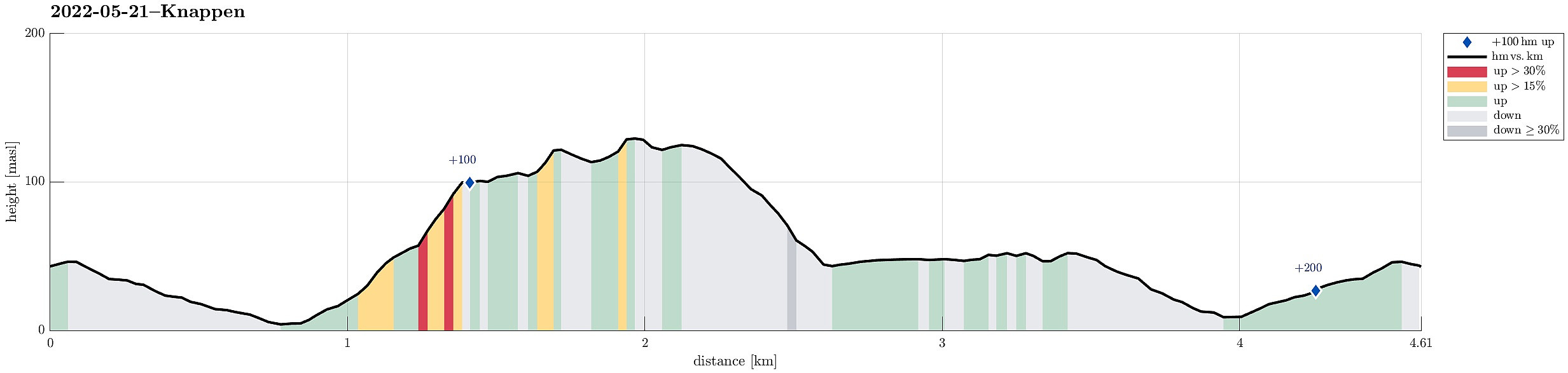 Just a standard walk over Knappen from Varden.
See also the related FB-page Hiking around Bergen, Norway .
Petter Bjørstad has a useful page about Knappen .
Web page UT.no from the Norwegian Trekking Association recommends another hike to Knappen .
Just a standard walk over Knappen from Varden.
See also the related FB-page Hiking around Bergen, Norway .
Petter Bjørstad has a useful page about Knappen .
Web page UT.no from the Norwegian Trekking Association recommends another hike to Knappen .
Rødsfjellet via Kråkedalen
- Datum:
- 17.05.2022
- Tourcharakter:
- Wanderung
- Tourlänge:
- 3:00h
- Entfernung:
- 8,8km
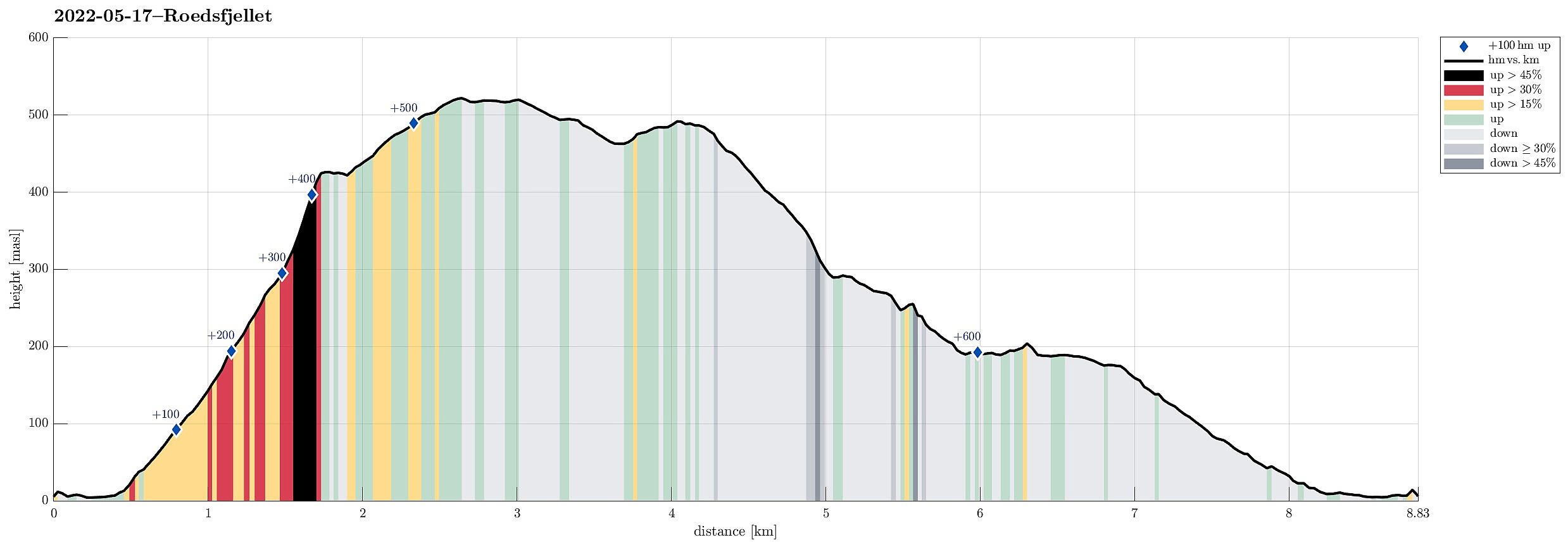 Rødsfjellet from the north/northeast. We drove via Osøyro to connect to Hegglandsdalvegen, which we followed to the small bay in the northeast of Rødsfjellet, where Øvredalsvegen forks off to the north. We parked right there and started our hike with a short walk along Ovredalsvegen until we came to the farm at the lowest end of Kråkedalen. Following first a forest road into Kråkedalen, we started our ascent to Rødsfjellet. Walking up Kråkedalen was straight-forward and easy and soon we had reached the of the forest road in the southeast of Halvardsåsen. There, at about 250mosl, we then deviated from the main valley and headed up and out of the main valley in southeastern direction. Finding a suitable side-valley for this purpose, we managed to reach the northern ridge of Rødsfjellet >>>
Skavlandsfjellet from Søyleplasset and Totlandsfjellet
- Datum:
- 15.05.2022
- Tourcharakter:
- Wanderung
- Tourlänge:
- 4:00h
- Entfernung:
- 11,4km
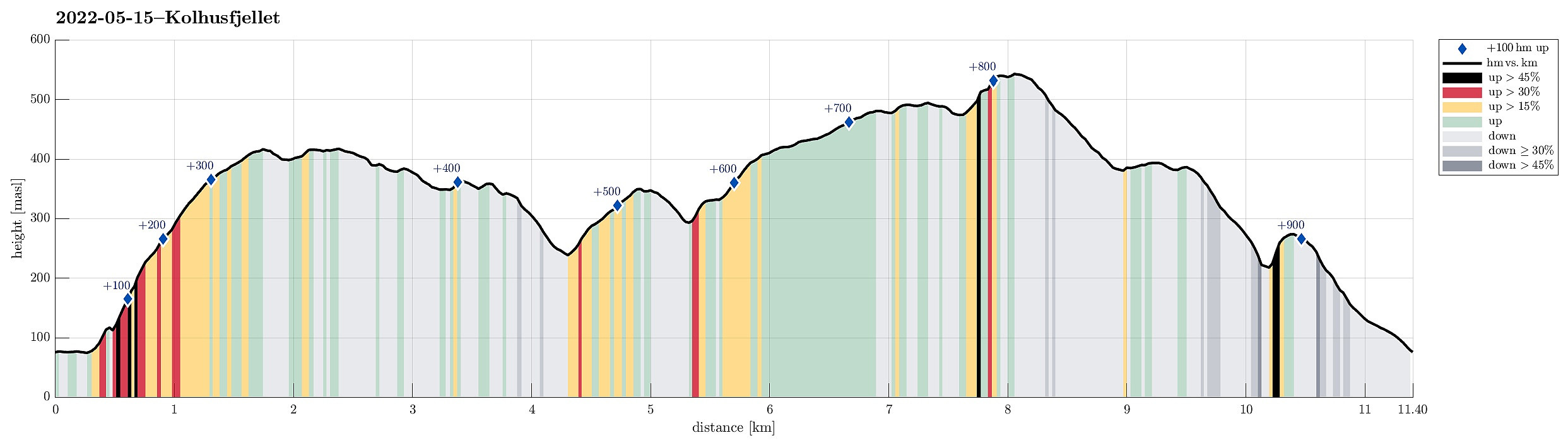 Ascending to Brattlandsfjellet from Brattland -- a long time plan! :-) We parked in the south of Søylevatnet, where the trail from Furedalen comes down from the south. After walking around Søyleplasset along the main road, we started our ascent to Dansebakken in the southwest of Søylevatnet. While we first were quite a bit unsure regarding how challenging this ascent would be, we then found out that a nice, minor trail actually leads up via Dansebakken! :-) Steadily ascending further upwards, we arrived at Skavdalsfjellet without any difficulties. We then crossed over Skavdalsfjellet, without including Flåfjellet further in the west, surrounding Fjellklovevatnet in its east. We then descended into Furedalen via the eastern hillside of Stordalsfjellet. There, we crossed the stream >>>
Oasen from Varden and back through Kanadaskogen
- Datum:
- 14.05.2022
- Tourcharakter:
- Spaziergang
- Tourlänge:
- 3:00h
- Entfernung:
- 10,2km
 After first walking to Oasen from Varden, I took a detour back to Varden through Kanadaskogen, including a crossing of Skjenhaugane, Langaheia, and Hesjaholten.
See also the related FB-page Hiking around Bergen, Norway .
After first walking to Oasen from Varden, I took a detour back to Varden through Kanadaskogen, including a crossing of Skjenhaugane, Langaheia, and Hesjaholten.
See also the related FB-page Hiking around Bergen, Norway .
