Archive - Date
Archive - Activity
-
Bike trip (137)
- Bike trip - mixed (51)
- Bike trip - road (9)
-
Other trip (1)
- Kayaking (1)
-
Other winter trip (4)
- Snowshoe trip (4)
- Ski trip (4)
- Trip by foot (740)
Archive - Geography
Peakbook-Friends


Collected lists
-
Bergen ≥ 50m pf. og ≥ 100 m.o.h.
(87/89)
 97%
97% -
Most dominating tops of the Bergen peninsula
(68/75)
90%
-
Utvalgte topper og turmål i Bergen
(316/350)
90%
-
Alle topper i Bergen
(357/398)
89%
-
Opptur Bergen
(100/113)
88%
-
De syv fjell rundt Bergen
(6/7)
85%
-
Sund ≥ 50m pf.
(14/18)
77%
-
Os ≥ 50m pf.
(25/34)
73%
-
Søyler (fastmerker) i Bergen
(68/100)
68%
-
Fjell ≥ 50m pf.
(21/32)
65%

Rødsfjellet via Kråkedalen
- Date:
- 17.05.2022
- Characteristic:
- Hike
- Duration:
- 3:00h
- Distance:
- 8.8km
 Rødsfjellet from the north/northeast. We drove via Osøyro to connect to Hegglandsdalvegen, which we followed to the small bay in the northeast of Rødsfjellet, where Øvredalsvegen forks off to the north. We parked right there and started our hike with a short walk along Ovredalsvegen until we came to the farm at the lowest end of Kråkedalen. Following first a forest road into Kråkedalen, we started our ascent to Rødsfjellet. Walking up Kråkedalen was straight-forward and easy and soon we had reached the of the forest road in the southeast of Halvardsåsen. There, at about 250mosl, we then deviated from the main valley and headed up and out of the main valley in southeastern direction. Finding a suitable side-valley for this purpose, we managed to reach the northern ridge of Rødsfjellet >>>
Skavlandsfjellet from Søyleplasset and Totlandsfjellet
- Date:
- 15.05.2022
- Characteristic:
- Hike
- Duration:
- 4:00h
- Distance:
- 11.4km
 Ascending to Brattlandsfjellet from Brattland -- a long time plan! :-) We parked in the south of Søylevatnet, where the trail from Furedalen comes down from the south. After walking around Søyleplasset along the main road, we started our ascent to Dansebakken in the southwest of Søylevatnet. While we first were quite a bit unsure regarding how challenging this ascent would be, we then found out that a nice, minor trail actually leads up via Dansebakken! :-) Steadily ascending further upwards, we arrived at Skavdalsfjellet without any difficulties. We then crossed over Skavdalsfjellet, without including Flåfjellet further in the west, surrounding Fjellklovevatnet in its east. We then descended into Furedalen via the eastern hillside of Stordalsfjellet. There, we crossed the stream >>>
Oasen from Varden and back through Kanadaskogen
- Date:
- 14.05.2022
- Characteristic:
- Walk
- Duration:
- 3:00h
- Distance:
- 10.2km
 After first walking to Oasen from Varden, I took a detour back to Varden through Kanadaskogen, including a crossing of Skjenhaugane, Langaheia, and Hesjaholten.
See also the related FB-page Hiking around Bergen, Norway .
After first walking to Oasen from Varden, I took a detour back to Varden through Kanadaskogen, including a crossing of Skjenhaugane, Langaheia, and Hesjaholten.
See also the related FB-page Hiking around Bergen, Norway .
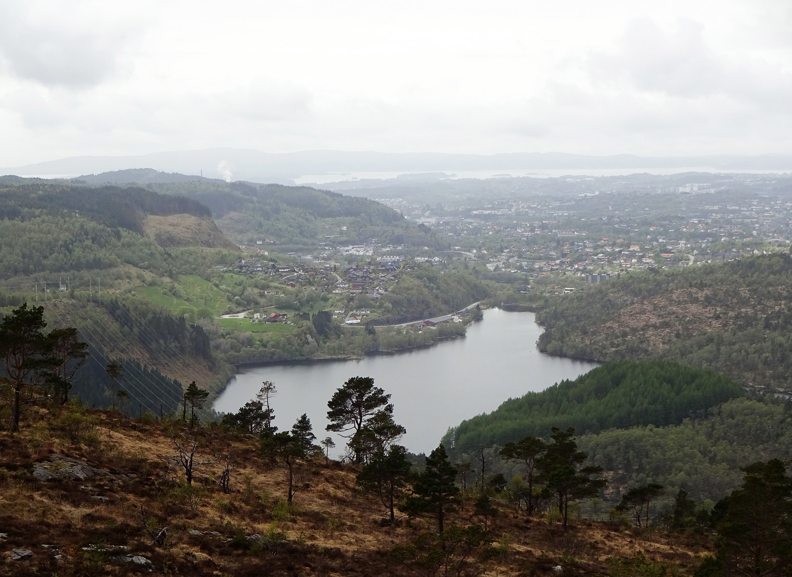
Up Lyderhorn and further to Fyllingsdalen
- Date:
- 24.04.2022
- Characteristic:
- Hike
- Duration:
- 2:30h
- Distance:
- 8.2km
 Hiking Lyderhorn and walking back to Fyllingsdalen from there. We took a bus via Loddefjord that was heading towards Olsvik, getting off where Olsvikskjenet is connected to Gamle Kjøkkelvikveien. Walking down there, we could easily connect to Lyderhornslien on the other, eastern side. From there, we then ascended to Lyderhorn following a minor trail that leads up a little further north than the main trail from Kjøkkelvik. Once on Lyderhorn, we continued in southern direction down again (into the direction of Skarpafjellet). When reaching the saddle right north of Skarpafjellet, we turned left and descended to the main highway-cross in the southeast of Lyderhorn. On the other side, we then walked up to Tennebekktjørna and further over to Spelhaugen. All in all, a nice hike connecting >>>
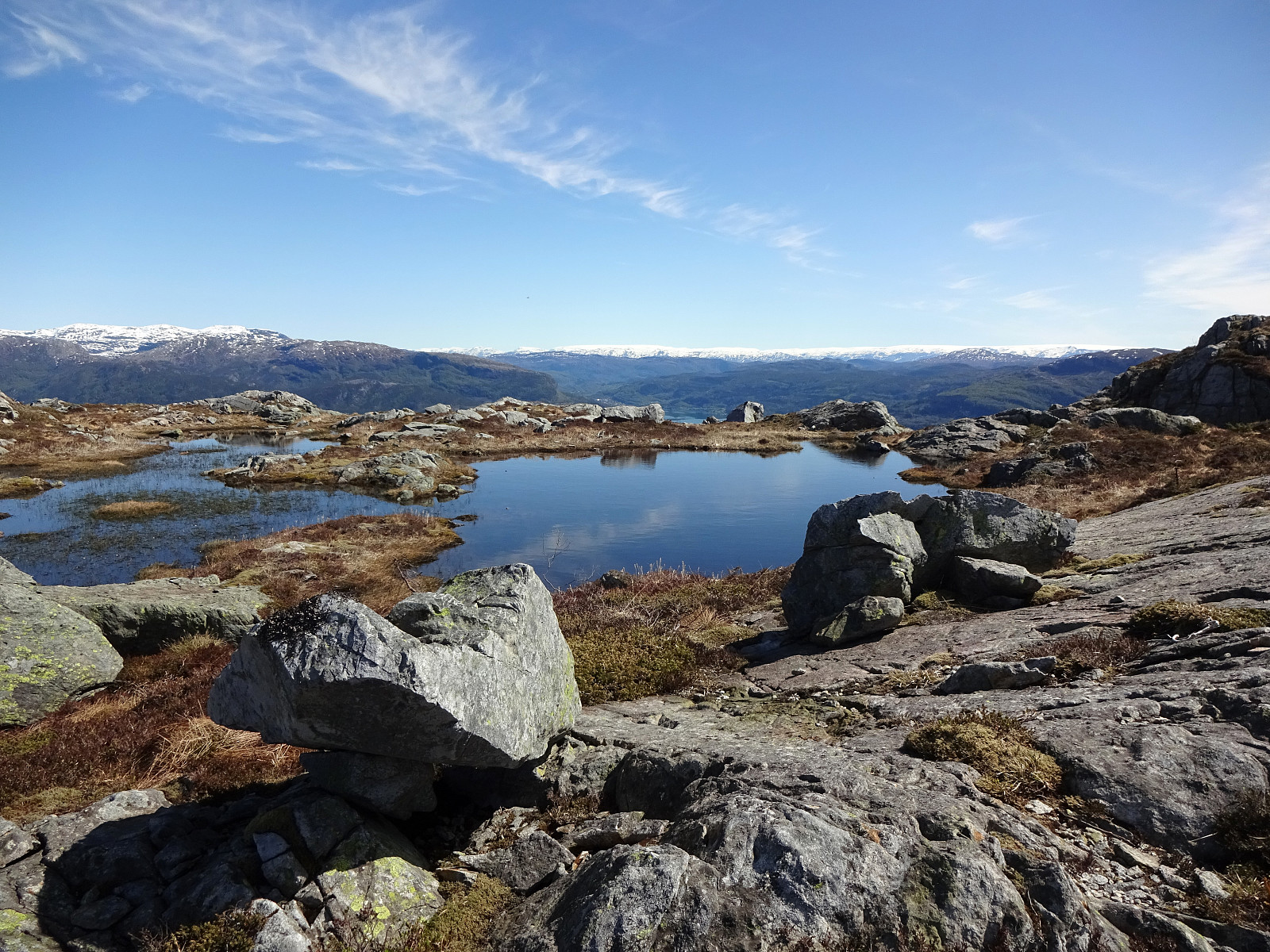
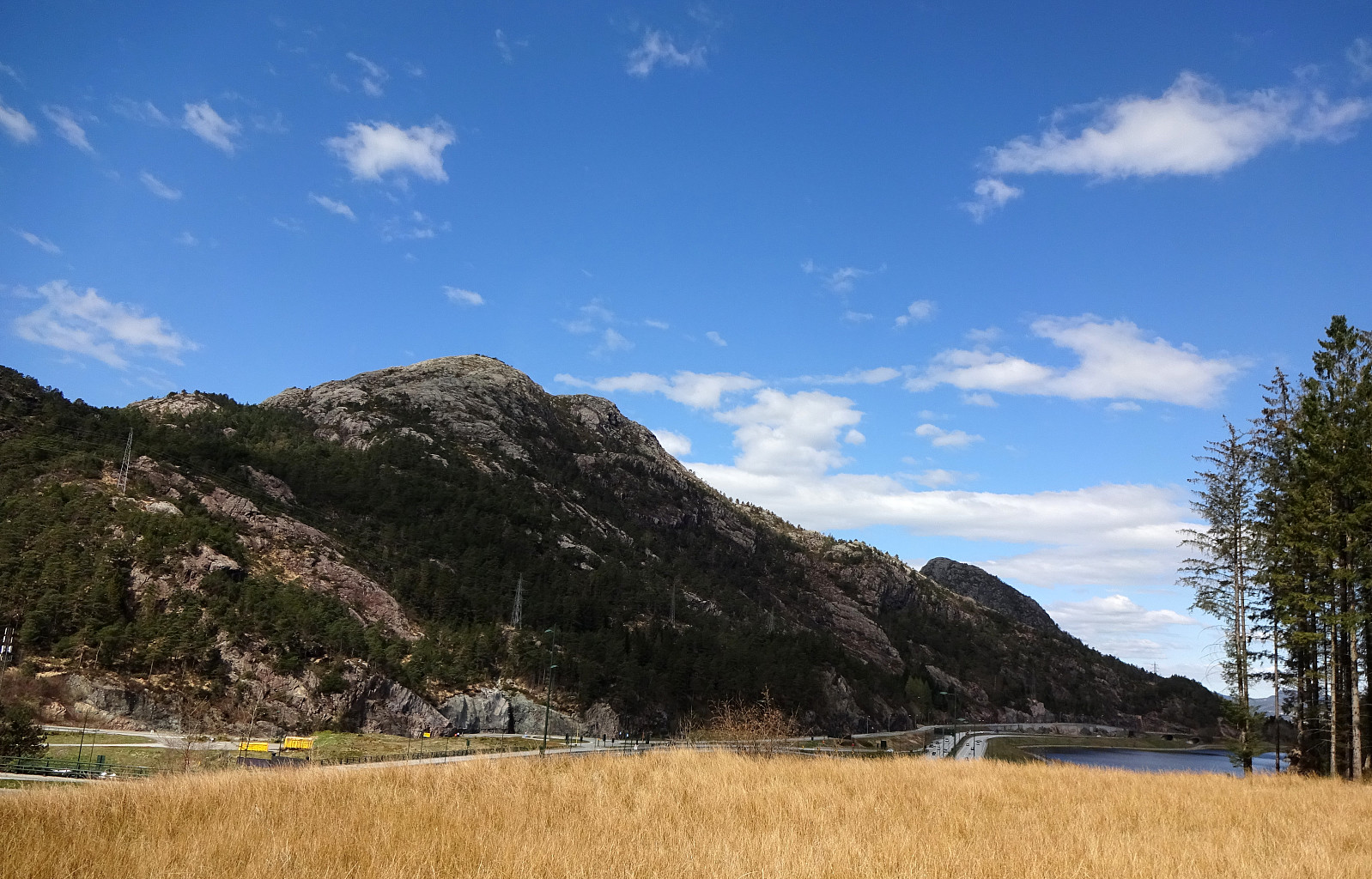
Liatårnet and Haganesfjellet from Liaskjeret
- Date:
- 23.04.2022
- Characteristic:
- Hike
- Duration:
- 3:30h
- Distance:
- 8.8km
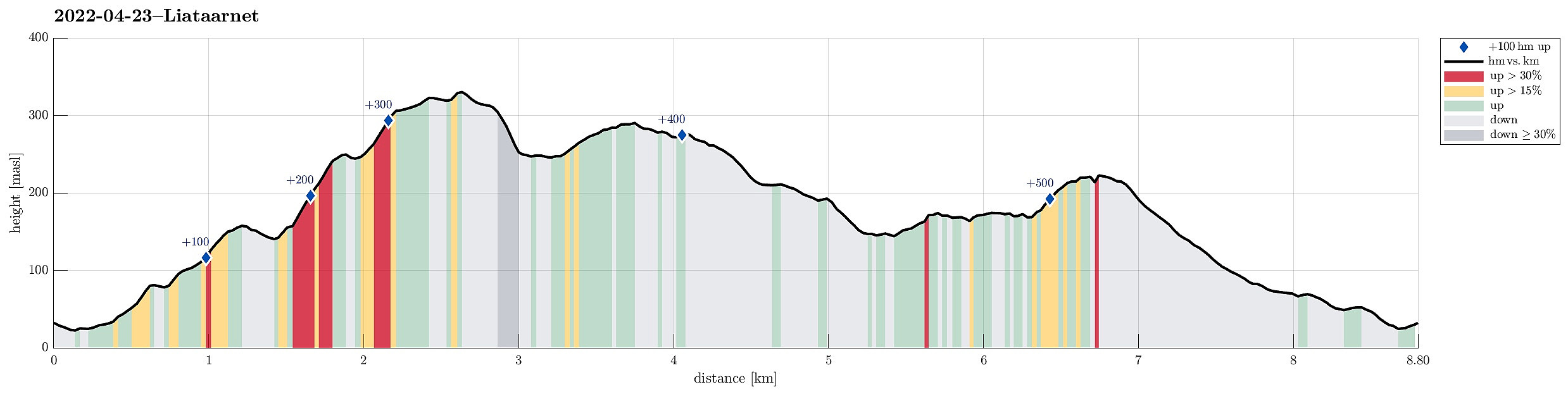 Liatårnet and Haganesfjellet from Liaskjeret. We parked next to Liaskjershallen in the southeast of Liatårnet on Sotra and walked first back (northwards) along Liaskjervegen until we found the spot where one can ascend to Dansarhaugen (just a few steps above the last houses on the hillside up to Liatårnet). We then crossed Skoradalen, mostly in northern direction, before we changed course after crossing over Bukkhelleren into a more northwestern direction, ascending rather straight up towards Liatårnet. Once on Liatårnet, we started our traverse across the heights south of Liatårnet, mostly in southern direction. South of Høgafjellet, we then came to Kattatjørna. This time, we passed by this lake on its eastern side, also stepping over Kattafjellet. It then was just straight southwards, >>>
Purkeneset from Eide
- Date:
- 02.04.2022
- Characteristic:
- Walk
- Duration:
- 2:30h
- Distance:
- 7.6km
 On a day with mixed weather, we made a short hike to Purkeneset north of Eide on Sotra. We parked near the road and crossed first Varden and Kyrkjehaugen before connecting to the trail that leads out to Purkeneset. From the top of Purkeneset we enjoyed some nice view across Kørelen, i.e., the rather big lake in the west of Hammarsland. After walking back along the same trail, we included a short excursion to Hopen in the north of Spilda. From there, we just walked back to Eide and called it a day.
Selected photos are available as Google photo album .
See also the related FB-page Hiking around Bergen, Norway .
Web page UT.no from the Norwegian Trekking Association recommends another hike to Purkaneset .
On a day with mixed weather, we made a short hike to Purkeneset north of Eide on Sotra. We parked near the road and crossed first Varden and Kyrkjehaugen before connecting to the trail that leads out to Purkeneset. From the top of Purkeneset we enjoyed some nice view across Kørelen, i.e., the rather big lake in the west of Hammarsland. After walking back along the same trail, we included a short excursion to Hopen in the north of Spilda. From there, we just walked back to Eide and called it a day.
Selected photos are available as Google photo album .
See also the related FB-page Hiking around Bergen, Norway .
Web page UT.no from the Norwegian Trekking Association recommends another hike to Purkaneset .
Høgafjellet and Haganesfjellet from Buabrekko
- Date:
- 26.03.2022
- Characteristic:
- Hike
- Duration:
- 3:00h
- Distance:
- 8.6km
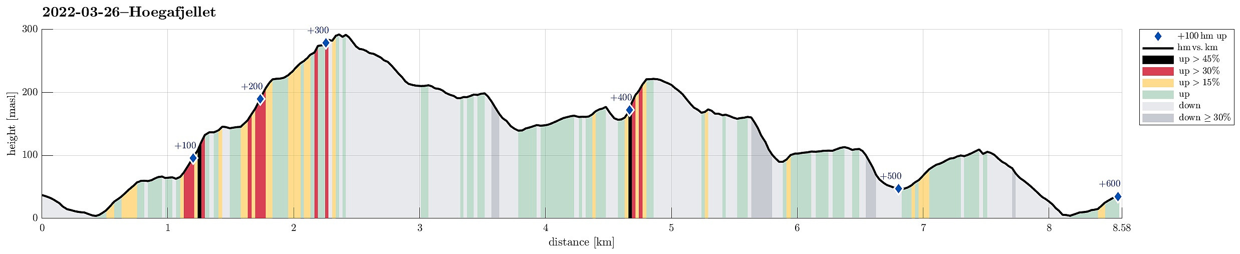 Høgafjellet and Haganesfjellet from Buabrekko. We parked near Tellnesvegen and walked down Buabrekko, crossing over the stream down from Kvernavatnet where it enters Pollen at its very northern end. On the other, eastern side, a trail leads up to the northern end of Ravnafjellet. Originally, we had planned to find a minor trail that should have forked off somewhere half way up in northeastern direction. Since we had not found this trail, we quickly found ourselves at the northern end of Ravnafjellet. There, we left the trail and continued through some relatively wet terrain northwards. Basically right west of Varden, we then found a good spot for ascending to the "next level", north of Vedatåna. There, we then also connected to a trail that circles Varden in its west. After >>>
Førdesveten from Kleppe
- Date:
- 20.03.2022
- Characteristic:
- Hike
- Duration:
- 3:00h
- Distance:
- 8.4km
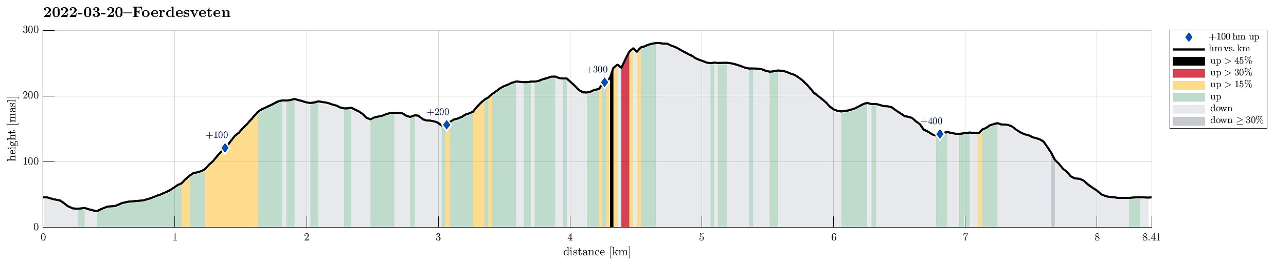 Hike to Førdesveten from Kleppe. We parked near Bjøllhaugen in the east of Kleppe and walked along the road towards Kleppe first. We then turned onto Kleppakslavegen into a northern direction, starting out ascent to Kleppaksla there. A proper trail leads all the way up, just east of Fenadalen. From Kleppaksla we then followed its northern ridge to Ramnaberget, offering some nice views into Kleppadalen in the west and across Trollavatnet in the north east. After passing by Trollavatnet, we crossed the trail leading to Veten from Kleppadalen and ascended to Storevarden in the west of Vetadalen. From there, then without a trail, we continued further north to Middagsberget. Even though Førdesveten has a prominent cliff on its western side, we still had planned to ascend to Veten from >>>
Storsåta and Stangelifjellet from Flaktveit
- Date:
- 06.03.2022
- Characteristic:
- Hike
- Duration:
- 4:00h
- Distance:
- 11.1km
 Hike to Storsåta and Vinddalen from Flaktveit. We parked where Hjortlandsvegen forks off Flaktveitsvingane and walked a little along Hjortlandsvegen, also crossing over the stream running down there in parallel to the path, until we found the trail that leads up to Storsåta at the lower end of Gjelet. This trail leads all the way up to the saddle at the upper end of Gjelet, right above Øvstebotn, on the western side of Gjelet. Instead of going directly to the saddle and then over and further to Storsåta, we first include a short excursion to Nukane right in the west of the saddle. From Nukane, it was then right over the saddle and up to Storsåta. Further, we then walked along the high ridge in the southeast of Storsåta until we came to Stangelifjellet, separating Setervatnet in the >>>
Orretua and Vardafjellet from Kaland
- Date:
- 27.02.2022
- Characteristic:
- Hike
- Duration:
- 2:00h
- Distance:
- 5.0km
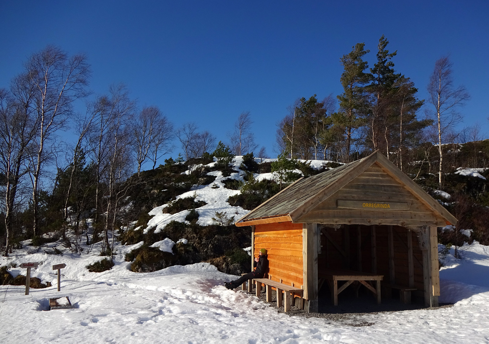 Hike from Kaland to Orretua and back to Kaland via Vardafjellet. We had parked near the sports arena of Kaland, walking from there in southeastern direction along Osvegen. Near Smådal, we ascended (without a trail) to the ridge in the northeast of the road. Once up the ridge, we then followed this ridge in northeastern direction (towards Orretua). About half way towards Orretua, we could have switched to a forrest road, which would have led us to Orretua quite easily. Instead, however, we continued along the "high edge" over the much lower extending Bontveitvegen (without a trail). This, first, was straight forward and easy. To connect, then, to Orretua, however, was a bit more challenging (but not really difficult). From Orretua, we then followed a nice trail to Vardafjellet >>>
