Archiv - Nach Datum
Archiv - Nach Aktivität
-
Andere Tour (1)
- Kayaking (1)
-
Andere Wintertour (4)
- Schneeschuhtour (4)
-
Fahrradtour (137)
- Fahrradtour Straße (9)
- Fahrradtour gemischt (51)
-
Fußtour (740)
- Bergtour (363)
- Jogging (18)
- Spaziergang (89)
- Wanderung (270)
-
Skitour (4)
- Tourenskilauf (4)
Archiv - Nach Geografie
Peakbookfreunde


Gesammelte Listen
-
Bergen ≥ 50m pf. og ≥ 100 m.o.h.
(87/89)
 97%
97% -
Most dominating tops of the Bergen peninsula
(68/75)
90%
-
Utvalgte topper og turmål i Bergen
(316/350)
90%
-
Alle topper i Bergen
(357/398)
89%
-
Opptur Bergen
(100/113)
88%
-
De syv fjell rundt Bergen
(6/7)
85%
-
Sund ≥ 50m pf.
(14/18)
77%
-
Os ≥ 50m pf.
(25/34)
73%
-
Søyler (fastmerker) i Bergen
(68/100)
68%
-
Fjell ≥ 50m pf.
(21/32)
65%

Short trip to Lyshovden via Bønes
- Datum:
- 26.09.2021
- Tourcharakter:
- Fahrradtour gemischt
- Tourlänge:
- 3:00h
- Entfernung:
- 14,7km
 To get a bit of fresh air, I decided to pay Lyshovden a short visit. To do so, I took my eBike and first headed towards the south of Bønes (from Varden via Straume). Near Bønes kirke I took the chance to step up to Storahugen, also. From there, I passed over Bønes via Bønesskogen, connecting to C. J. Hambros vei on the other side. Once at Lyshovden, I first visited the southern hill. After completing a short round, I cycled down to the northern part of Lyshovden. Together with a friend, I then payed Nordre Lyshovden a short visit, before walking around it and getting back up to Lyshovden (then from the north). After that, it was basically to cycle home, again. In surprisingly warm autumn weather, it was nice to get some fresh air! :-)
See also the related FB-page Hiking around Bergen, Norway .
To get a bit of fresh air, I decided to pay Lyshovden a short visit. To do so, I took my eBike and first headed towards the south of Bønes (from Varden via Straume). Near Bønes kirke I took the chance to step up to Storahugen, also. From there, I passed over Bønes via Bønesskogen, connecting to C. J. Hambros vei on the other side. Once at Lyshovden, I first visited the southern hill. After completing a short round, I cycled down to the northern part of Lyshovden. Together with a friend, I then payed Nordre Lyshovden a short visit, before walking around it and getting back up to Lyshovden (then from the north). After that, it was basically to cycle home, again. In surprisingly warm autumn weather, it was nice to get some fresh air! :-)
See also the related FB-page Hiking around Bergen, Norway .
Vassenden and Store Kongshaugen
- Datum:
- 25.09.2021
- Tourcharakter:
- Bergtour
- Tourlänge:
- 3:15h
- Entfernung:
- 8,9km
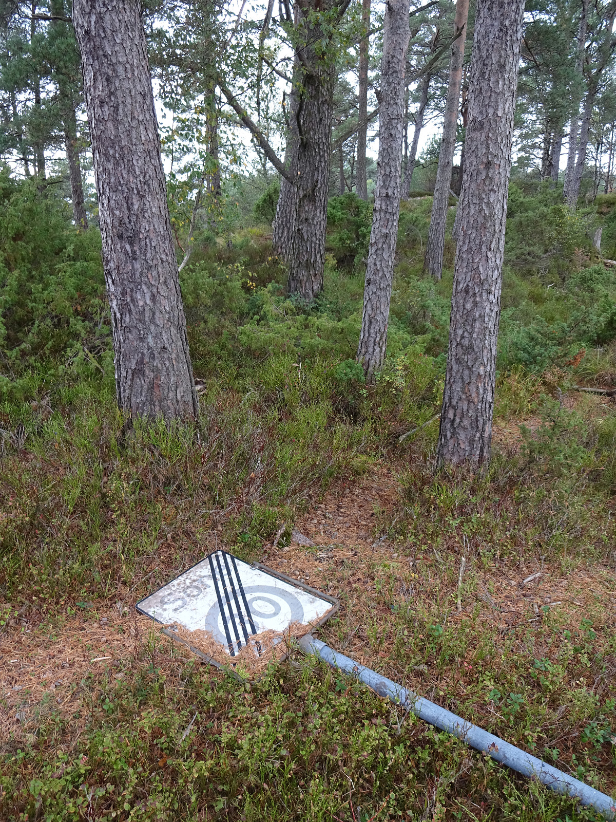
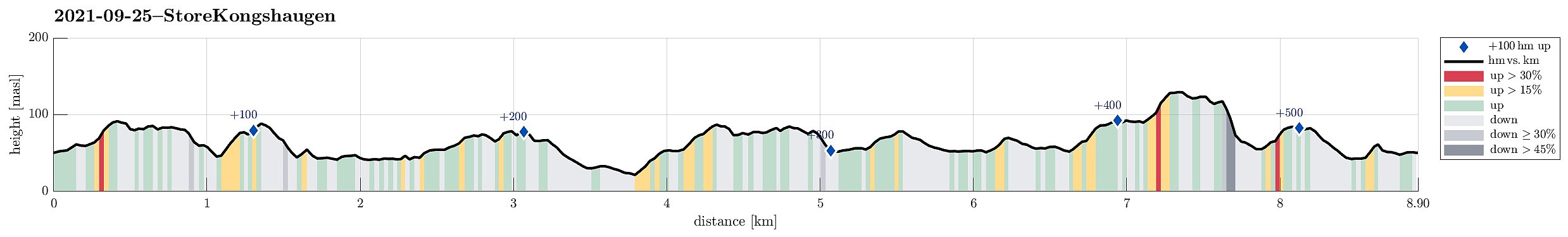 I needed some fresh air and thus decided to make a short hike through the forest in the north of Store Kongshaugen. To get there, I cycled first into the direction of Haakonsvern, before turning to the right and onto Vassendveien (near the entry to the military area at Haakonsvern). Right below Ørnahaugen, I left my bike behind and started my little forest hike. I first walked in northern direction (not directly towards Vassenden though) and found a nice trail which then brought me up to Grønabrekka. Grønabrekka has some steep sides towards the west, making it really nice to traverse it along its south-north top line. After walking over all of it, I found myself not far from Høghaugen (and not far from Storavatnet, neither). I included Høghaugen via a little loop, before heading >>>
Eggene (and back via Raudlifjellet)
- Datum:
- 19.09.2021
- Tourcharakter:
- Wanderung
- Tourlänge:
- 3:00h
- Entfernung:
- 6,9km
 With most of the day overcast, the day's goal was an excursion into the forest in the southeast of Hausdalen. We drove first along E39 into the south of Bergen, parking not far from this road near Bahus. From there, we first walked along the road, crossing Straumen on the road's bridge, before quickly finding a tractor road that would lead us behind the houses (in northeastern direction, towards Storerinden). Once past the houses, we also left the tractor road, ascending to the gentle ridge (Storerinden). Once on the ridge, it was then straight-forward and easy to follow it (in northeastern direction). This way, one gets directly to Høghaugen (in the northwest of Breidalen) with some first nice views into Hausdalen (and down to Hauglandsvatnet). To connect further to Eggene, one needs >>>
Sveningen via Åsen from Brekkedalen
- Datum:
- 12.09.2021
- Tourcharakter:
- Wanderung
- Tourlänge:
- 6:30h
- Entfernung:
- 13,2km
 The weather forecast has been promising (very promising), even in the morning, so what could go wrong? :-)
Considering the expected day full of sunshine and pleasant hiking temperatures, we aimed at something slightly "bigger" and since we had not visited Sveningen recently, we planned a nice hike over this mountain! To make this a bit more interesting, we decided to include an ascent that we had not tried before (and of which we also could not find any other report from others), i.e., up to Åsen, first, from the north, and then over the northernmost part of the Sveningen massif (in eastwards direction, kind of "parallel" to Brekkedalen in the north of it). To get started, we drove into Hausdalen (from E39, south of Bergen) and all the way into it (until the parking >>>
The weather forecast has been promising (very promising), even in the morning, so what could go wrong? :-)
Considering the expected day full of sunshine and pleasant hiking temperatures, we aimed at something slightly "bigger" and since we had not visited Sveningen recently, we planned a nice hike over this mountain! To make this a bit more interesting, we decided to include an ascent that we had not tried before (and of which we also could not find any other report from others), i.e., up to Åsen, first, from the north, and then over the northernmost part of the Sveningen massif (in eastwards direction, kind of "parallel" to Brekkedalen in the north of it). To get started, we drove into Hausdalen (from E39, south of Bergen) and all the way into it (until the parking >>>
Micro-tops south of Fyllingsdalen
- Datum:
- 05.09.2021
- Tourcharakter:
- Fahrradtour gemischt
- Tourlänge:
- 3:00h
- Entfernung:
- 20,7km
 I took the chance to "round up" a few micro-"tops" in the vicinity. This combined eBiking-hiking trip brought me first to Ruskeneshaugen (I do not recommend to follow my track there; all in all, I'm unsure whether there's any good way to get there; and further, it's unclear, why one would get there in the first place), before I continued into the direction of Grimstad (my next goal was to cross over Dolvikfjellet). At Hammarsland, I followed Hammarslandbakken up (basically to where it then also ends) and ascended from there (first into the direction of Dansehaugen in southwestern direction). At about 100mosl, I connected to a trail, which brought me further up to the saddle (with Dolvikfjellet in the east). Crossing over "all the heights" of Dolvikfjellet in >>>
Naknesåta, Austefjellet, and Landåsfjellet
- Datum:
- 04.09.2021
- Tourcharakter:
- Wanderung
- Tourlänge:
- 3:00h
- Entfernung:
- 8,0km
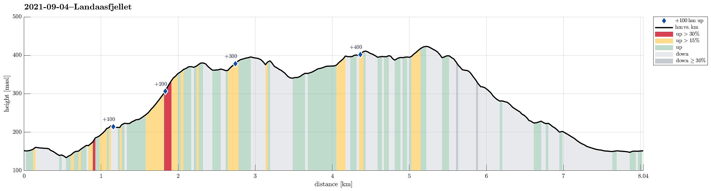 On my Helldal hike from the previous weekend, I had followed the lowest bit of a trail that appeared to lead further up into the direction of Søre Gløvrevatnet. This time, we wanted to look deeper into this and find out! :-) We drove up Sanddalsringen and parked near the saddle, where Sædalssvingene leaves to the east. From there, we first walked along Helldalslia (almost all the way down to house #45) to connect to a proper trail head. In the last swing of Helldalslia, a path for pedestrians, who wish to connect Helldalslia with Hardangervegen further down in the valley, leaves to the east. We first followed this path a little too long, before going back a few steps and taking the right trail that leads through the forest (slightly upwards in northeastern direction). Once under the power line, >>>
