Archiv - Nach Datum
Archiv - Nach Aktivität
-
Andere Tour (1)
- Kayaking (1)
-
Andere Wintertour (4)
- Schneeschuhtour (4)
-
Fahrradtour (137)
- Fahrradtour Straße (9)
- Fahrradtour gemischt (51)
-
Fußtour (740)
- Bergtour (363)
- Jogging (18)
- Spaziergang (89)
- Wanderung (270)
-
Skitour (4)
- Tourenskilauf (4)
Archiv - Nach Geografie
Peakbookfreunde


Gesammelte Listen
-
Bergen ≥ 50m pf. og ≥ 100 m.o.h.
(87/89)
 97%
97% -
Most dominating tops of the Bergen peninsula
(68/75)
90%
-
Utvalgte topper og turmål i Bergen
(316/350)
90%
-
Alle topper i Bergen
(357/398)
89%
-
Opptur Bergen
(100/113)
88%
-
De syv fjell rundt Bergen
(6/7)
85%
-
Sund ≥ 50m pf.
(14/18)
77%
-
Os ≥ 50m pf.
(25/34)
73%
-
Søyler (fastmerker) i Bergen
(68/100)
68%
-
Fjell ≥ 50m pf.
(21/32)
65%

Round around Jordavatnet
- Datum:
- 23.05.2021
- Tourcharakter:
- Bergtour
- Tourlänge:
- 2:00h
- Entfernung:
- 6,0km
 The later afternoon seemed to be OK for a short walk and so we drove into the direction of Fana. Before the street starts to lead up to Fanafjellet, we turned left near the church of Fana and continued into the direction of Kalandsvatnet. Once there, and instead of following the "main road" in the northwest of Kalandsvatnet, we followed the very narrow road in the southwest of Kalandsvatnet into the direction of Kismul. At Ytre Sandvika, we parked right next to the road and started our walk from there. We first walked a little bit "back" (in northern direction), following a side road that is a bit higher up than Kismulvegen. Near house #141, this road splits again and we continued along the upper part. Maybe only 100m further along this stretch, we turned left (onto >>>
Austefjellet via Kurlarinden
- Datum:
- 22.05.2021
- Tourcharakter:
- Wanderung
- Tourlänge:
- 3:30h
- Entfernung:
- 7,5km
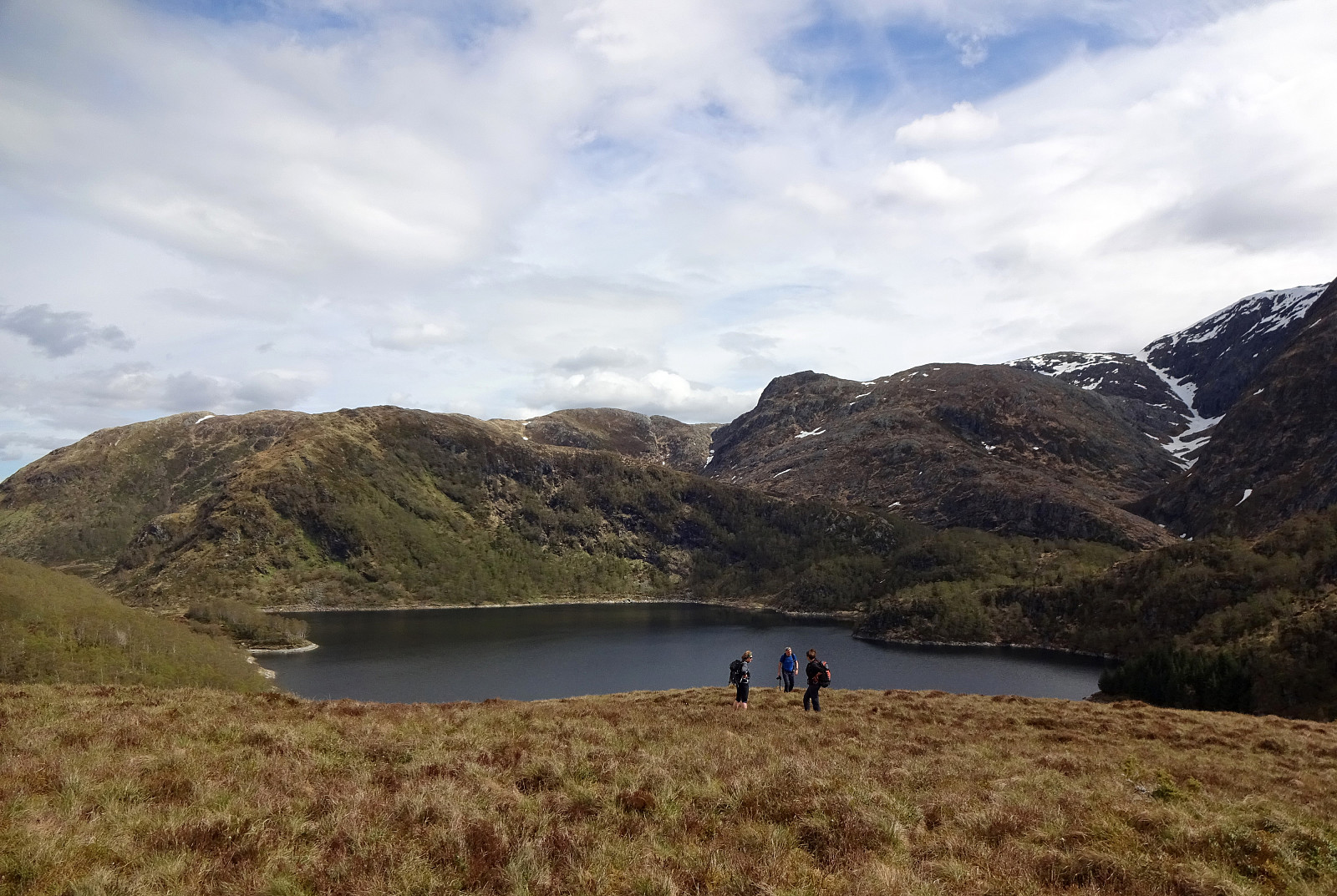 With the goal to do some nice, medium-sized hike, we aimed at Austefjellet, starting from Osavatnet. We thus drove into the direction of Arna (from Bergen), leaving the main road shortly before coming close to Haukelandsvatnet. Driving first towards Unneland, we then continued along Gullfjellsvegen to get up to the parking place in the north of Osavatnet. Walking first along Gullfjellsvegen further eastwards, we came to the place in the west of Taushaugen, where the roads split (with the "main road", Gullfjellsvegen, making a turn to the left, while a minor road continues straight-ahead, into the direction of Kurlatjørna). Following this minor road, we soon after had passed by Kurlatjørna (on our right, south of us), coming to the end of this road (it's continuing behind a closed >>>
Nice evening walk around Småvatnet
- Datum:
- 20.05.2021
- Tourcharakter:
- Bergtour
- Tourlänge:
- 2:00h
- Entfernung:
- 5,8km
 With still some nice light to go, we decided to use the evening for a quick excursion into our (extended) neighborhood. After driving a bit towards the west of Bergen, we left the main road before getting all the way to Sotrabroen and continued along Alvøveien until we came close to Småvatnet. After parking near the north end of Småvatnet, we started our hike around this lake in clockwise direction. We first followed a minor forest road in northeastern direction, which eventually would have brought us to the soccer fields in the north of Småvatnet. Before getting close to them, however, we turned right (and in southern direction), ascending to the little cliff that extends towards the south from the soccer fields. Once up there, we then continued along minor trails to stay close to >>>
Evening walk to Mindebakken
- Datum:
- 19.05.2021
- Tourcharakter:
- Bergtour
- Tourlänge:
- 1:30h
- Entfernung:
- 4,0km
 To get a bit of fresh air after another day of home office, we drove to the parking at Øvre Kråkenes at the southern end of Løvstien and started from there. Before continuing into the direction of Løvstien, we first made a quick detour to what possibly is called Casperkollen, on the southern side of the parking place. After quickly walking up and down this little height, we crossed over the road and continued "in parallel" to Løvstien. After crossing over Lerkhaugen, we crossed Løvstien and made a quick ascent to Lisahaugen, also. On the other, northeastern side of Lisahaugen, we followed the ridge east of Løvstien upwards until we crossed Løvstien once again to get closer to Mindebakken at Litla Langafjellet. There, we then followed a trail that for the first 40 height >>>
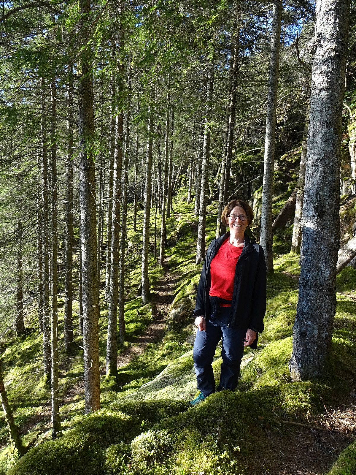
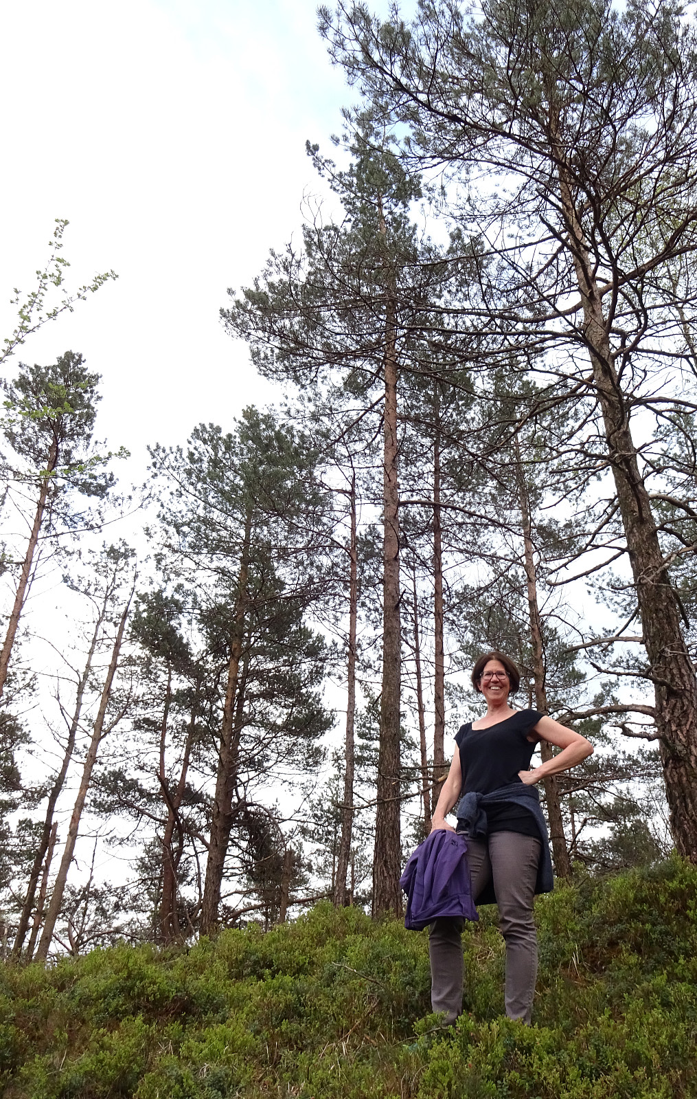
Steinafjellet and Skjerhaugen
- Datum:
- 16.05.2021
- Tourcharakter:
- Bergtour
- Tourlänge:
- 1:00h
- Entfernung:
- 3,0km
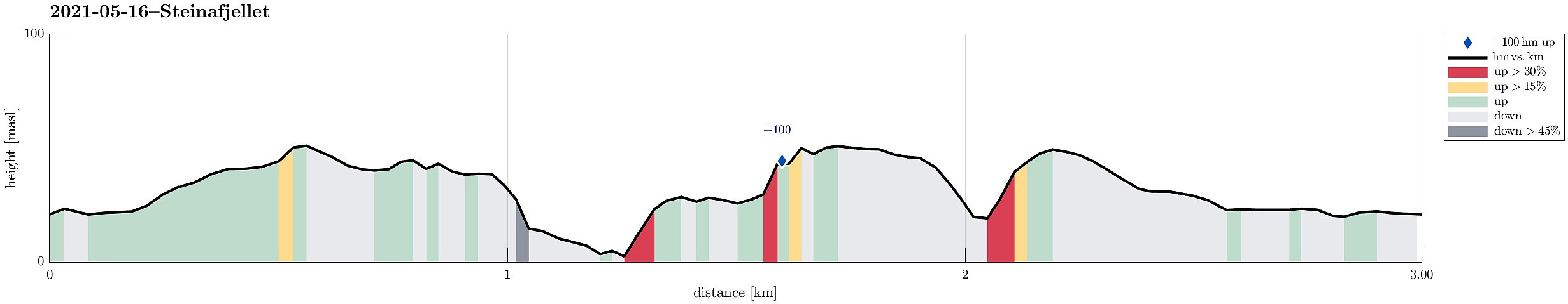 Being already very close, I decided to make a quick excursion to Steinafjellet and the coastal area there. After parking next to the school in Landro, my first "challenge" was to get behind the used areas (towards the open landscape with Steinafjellet). I found a way to pass by a farm there, but would have found it even better with a trail head to use. Once behind the farm area, proceeding to Steinafjellet was quick and easy. Once there, I decided to walk a little further (towards the coast) and started to do so in northwestern direction from Steinafjellet. This brought me within a few minutes to a little height, just in the south of Sørdalen. In order to get even closer to the sea, I then descended into Sørdalen, choosing a place which was a little steeper than what was just >>>
Visiting Myrdal Våpenlager and Skavdalsfjellet
- Datum:
- 15.05.2021
- Tourcharakter:
- Wanderung
- Tourlänge:
- 4:00h
- Entfernung:
- 7,9km
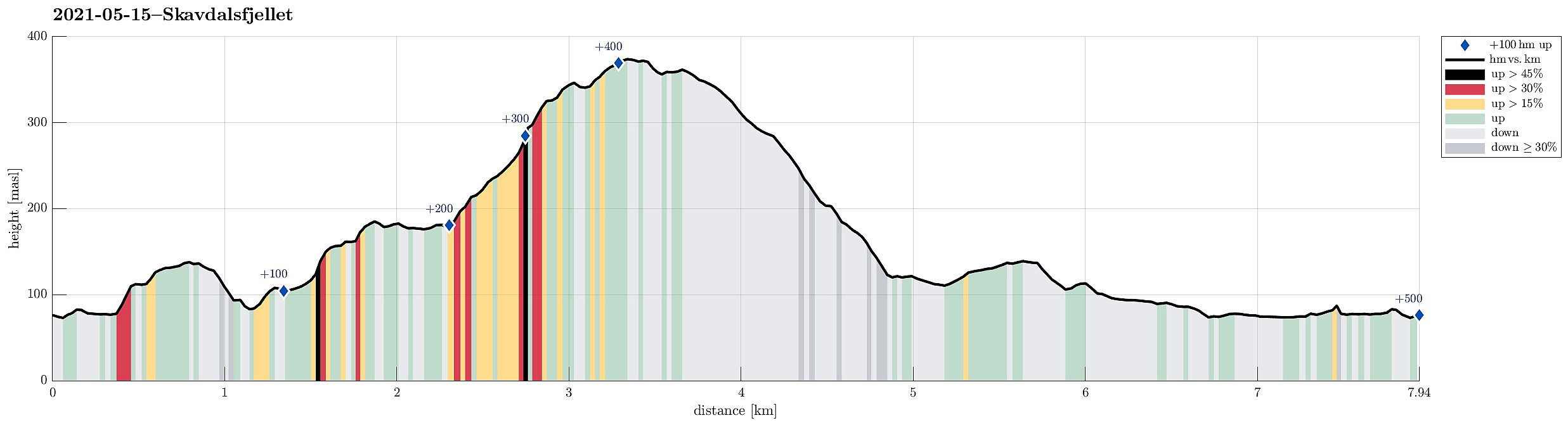 With the weather being forecasted as "grayish", the plan was to do something below the higher tops. Ever since we had visited Bautasteinen in the north of Krokvatnet near the top of Livarden , which made us read up on Johannes Dyngeland and related history, we had a little plan "on the shelf" to "one day" go and search for this place in Langedalen, where they apparently had hidden weapons while resisting the NS-occupation of Norway. We started in Nedre Dyngeland, where it is not really easy to find an appropriate parking spot. After passing by Grøvlet in the north of Dyngelandsvatnet, we approached the saddle in the north of Fjellet (marked with Fjellsenden on the map) on something that could be called a minor trail. Once on the saddle, we decided to also include a short detour via Fjellet, stepping up to its "top" >>>
Storekvitefjellet, Lauvåsen, Naknekampen, and Høgeåsen
- Datum:
- 08.05.2021
- Tourcharakter:
- Wanderung
- Tourlänge:
- 3:30h
- Entfernung:
- 9,3km
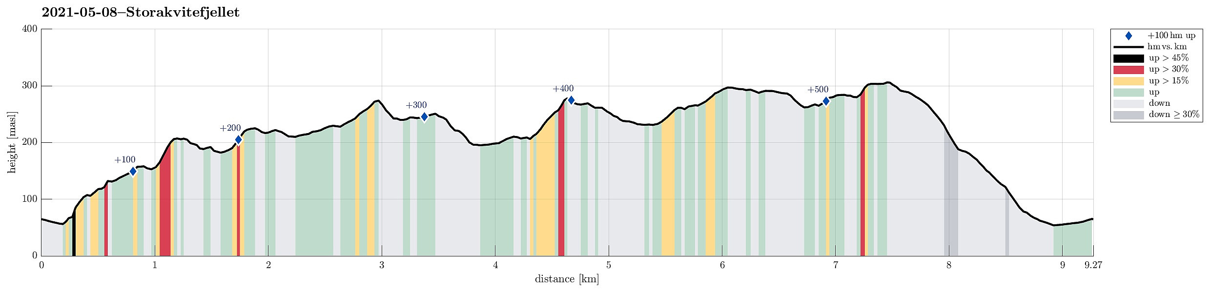 After starting our day with some scepticism regarding the expected weather, we then decided to still head for a nearby hike. Double-checking the weather prediction map suggested that the south of Bergen may see somewhat better wheater. We thus aimed at a hike there, not too far from Bergen, and since we had not been on Storekvitefjellet, we decided to give it a try. :-) After first driving to Fana, we then crossed Fanafjellet von Fanafjellsvegen until we came close to Nordvika on the southern side of Fanafjellet. There we parked next to the road and started our hike towards Stonghaugen, first. The southwestern side of Stonghaugen is a bit steep, but not really any problem to get up to. Already a bit up there, we enjoyed our first nice views back to Nordvika. From Stonghaugen, it then >>>
Gladihaug and Krossane from Votno
- Datum:
- 01.05.2021
- Tourcharakter:
- Wanderung
- Tourlänge:
- 4:00h
- Entfernung:
- 13,5km
 For a while, we had contemplated to hike Gladihaug one day. This morning, we decided to finally do it! :-) We took the car to the north of Bergen, driving along E39 towards Knarvik. Once there, we turned left in Knarvik and continued along road 57 (into the direction of Mongstad in the north of Knarvik). After driving through Espelandstunnelen and Herlandstunnelen on Lindåsvegen, we parked right next to the road (where one also could drive off to Seim only a bit further in the north). We then started our hike towards Gladihaug by walking into Votno, approaching the significant ridge of Hellefjellet from its north. As soon as we found ourselves on this ridge (in the south of Votno), we also had found a simple trail that was easy to follow. At about 250mosl, this trail even got "upgraded" >>>
