Archiv - Nach Datum
Archiv - Nach Aktivität
-
Andere Tour (1)
- Kayaking (1)
-
Andere Wintertour (4)
- Schneeschuhtour (4)
-
Fahrradtour (137)
- Fahrradtour Straße (9)
- Fahrradtour gemischt (51)
-
Fußtour (740)
- Bergtour (363)
- Jogging (18)
- Spaziergang (89)
- Wanderung (270)
-
Skitour (4)
- Tourenskilauf (4)
Archiv - Nach Geografie
Peakbookfreunde


Gesammelte Listen
-
Bergen ≥ 50m pf. og ≥ 100 m.o.h.
(87/89)
 97%
97% -
Most dominating tops of the Bergen peninsula
(68/75)
90%
-
Utvalgte topper og turmål i Bergen
(316/350)
90%
-
Alle topper i Bergen
(357/398)
89%
-
Opptur Bergen
(100/113)
88%
-
De syv fjell rundt Bergen
(6/7)
85%
-
Sund ≥ 50m pf.
(14/18)
77%
-
Os ≥ 50m pf.
(25/34)
73%
-
Søyler (fastmerker) i Bergen
(68/100)
68%
-
Fjell ≥ 50m pf.
(21/32)
65%

Hetlebakksåta and Erviknipa from Breistein
- Datum:
- 28.02.2021
- Tourcharakter:
- Wanderung
- Tourlänge:
- 2:30h
- Entfernung:
- 7,2km
 We somehow thought that it may be worthwhile to explore the ridge in the south of Erviknipa, southeast of Hetlebakksåta. We drove to Breistein via Åsane and parked quite a bit south on Breisteinvegen. According to our plan to hike a round, we first walked northwards (towards Nygård) to find an opportunity for ascending to Hetlebakksåta. When looking at the map before leaving, we had estimated that it should be possible to ascend towards Fosseskaret there and indeed this is well possible from Nygård (the "trails" up there are not very clear, but possible to find and certainly also possible to ascend, just a bit steep). At about 130mosl, we entered the little valley that comes down from Fosseskaret, right where there is a little waterfall down towards Breistein. At Fosseskaret, >>>
Lerkhaugen, Lisahaugen, and Gullsteinen
- Datum:
- 21.02.2021
- Tourcharakter:
- Bergtour
- Tourlänge:
- 2:00h
- Entfernung:
- 5,1km
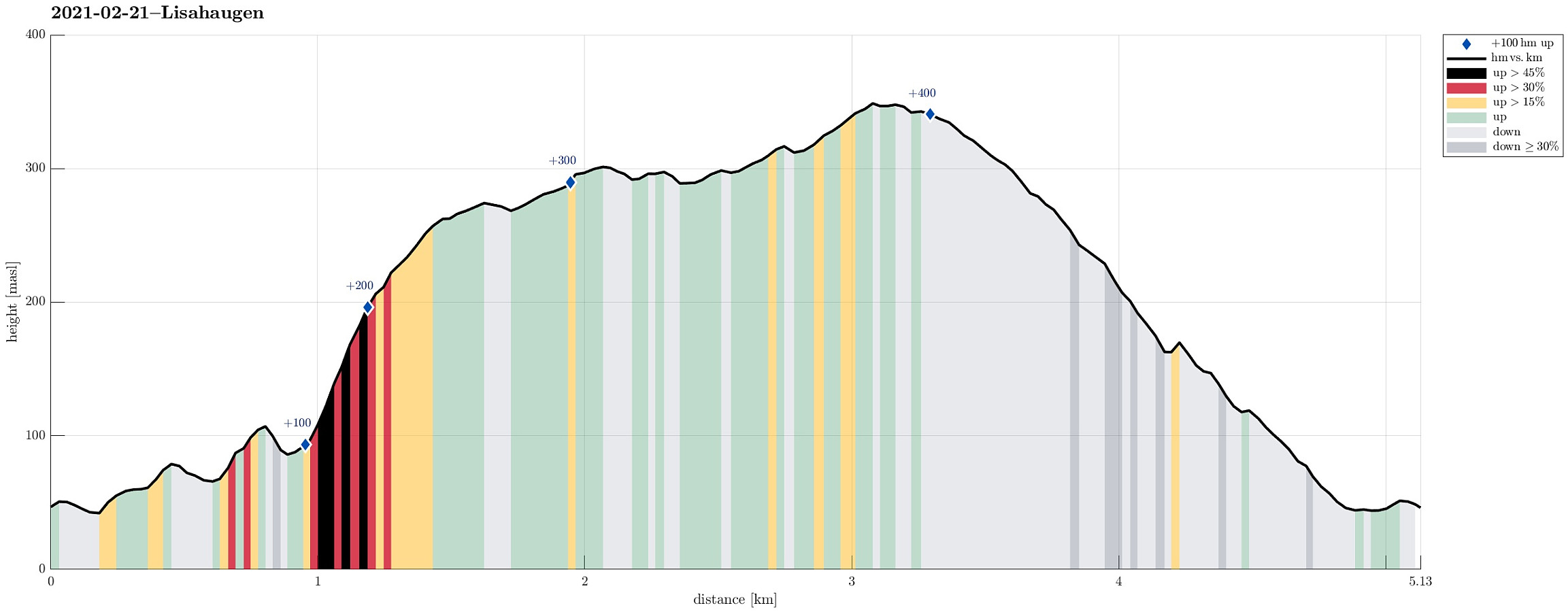 With only a bit of time available, we headed for a short hike in the neighborhood. To include at least one spot of (limited) interest, we decided to aim for Lisahaugen near Langegården in the northeast of Kråkenes. We parked near the southern end of Løvstien (at Øvre Kråkenes) and ascended to Lerkhaugen, first. Thereafter, we crossed Løvstien and continued to Lisahaugen (from its south). Crossing Lisahaugen south-to-north, we came back to Løvstien (for a moment), before changing course, again, and then aiming at Langatjørna in the west of Mindebakken. This ascent from Løvstien is a bit steep, but well possible and actually quite nice through th forest there. North of Langatjørna we then turned around, heading back via Gullsteinen. South of Gullstølen, we descended along some >>>
Walk along Sælenvatnet
- Datum:
- 14.02.2021
- Tourcharakter:
- Bergtour
- Tourlänge:
- 1:00h
- Entfernung:
- 2,3km
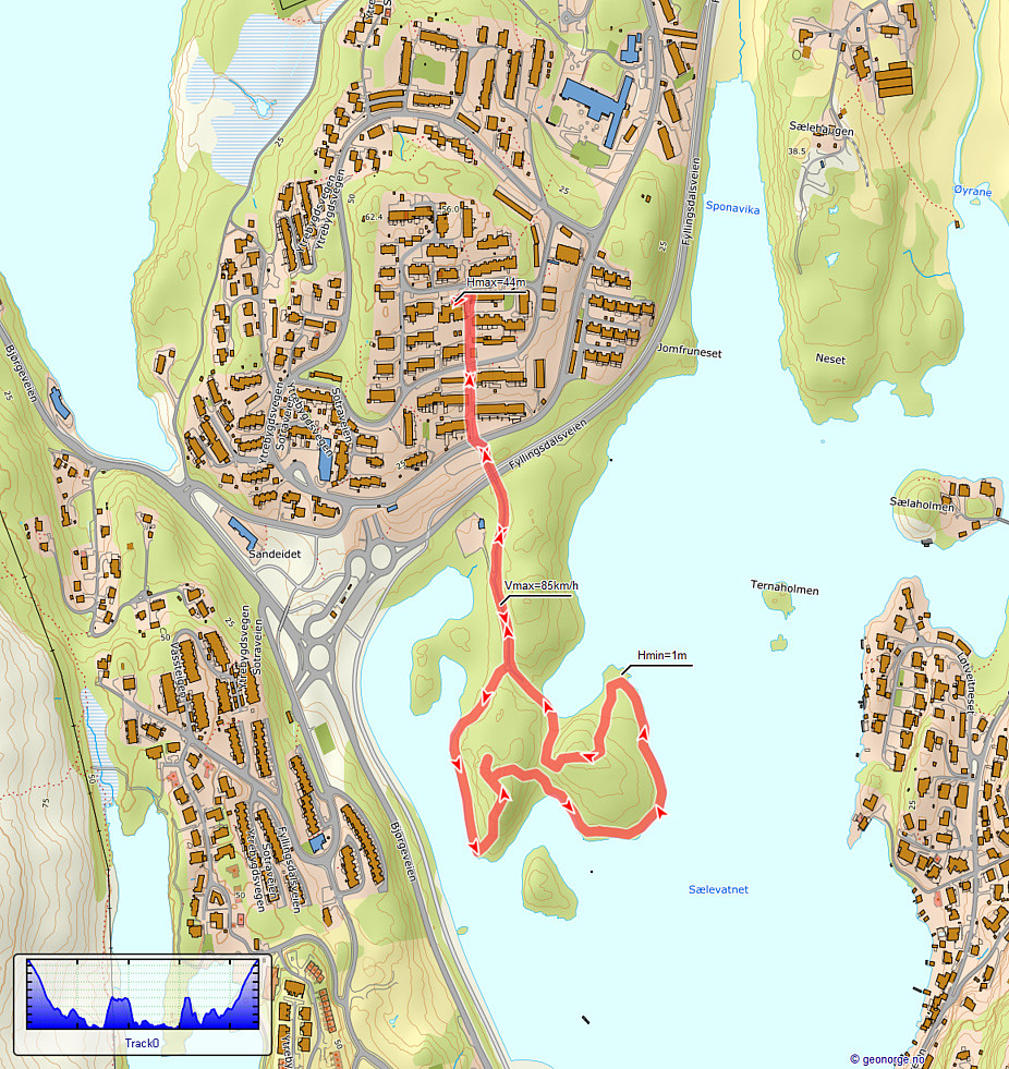 With just a little time at our disposal, we decided to quickly get a little fresh air and make a short walk along the shoreline of (frozen) Sælenvatnet. After walking down from Varden, we crossed over Fyllingsdalsveien, using a small bridge near the big junction with Bjørgeveien. Once on the other side, we walked onto this particular peninsula that extends into Sælenvatnet on its western side. Following some small, but "beaten" paths, we rounded most of this peninsula, before heading back and up to Varden, again. Nice with all that snow! :-)
See also the related FB-page Hiking around Bergen, Norway .
With just a little time at our disposal, we decided to quickly get a little fresh air and make a short walk along the shoreline of (frozen) Sælenvatnet. After walking down from Varden, we crossed over Fyllingsdalsveien, using a small bridge near the big junction with Bjørgeveien. Once on the other side, we walked onto this particular peninsula that extends into Sælenvatnet on its western side. Following some small, but "beaten" paths, we rounded most of this peninsula, before heading back and up to Varden, again. Nice with all that snow! :-)
See also the related FB-page Hiking around Bergen, Norway .
Holefjellet via Storhovden, Eikelifjellet, Gravdalsfjellet
- Datum:
- 13.02.2021
- Tourcharakter:
- Bergtour
- Tourlänge:
- 3:00h
- Entfernung:
- 9,3km
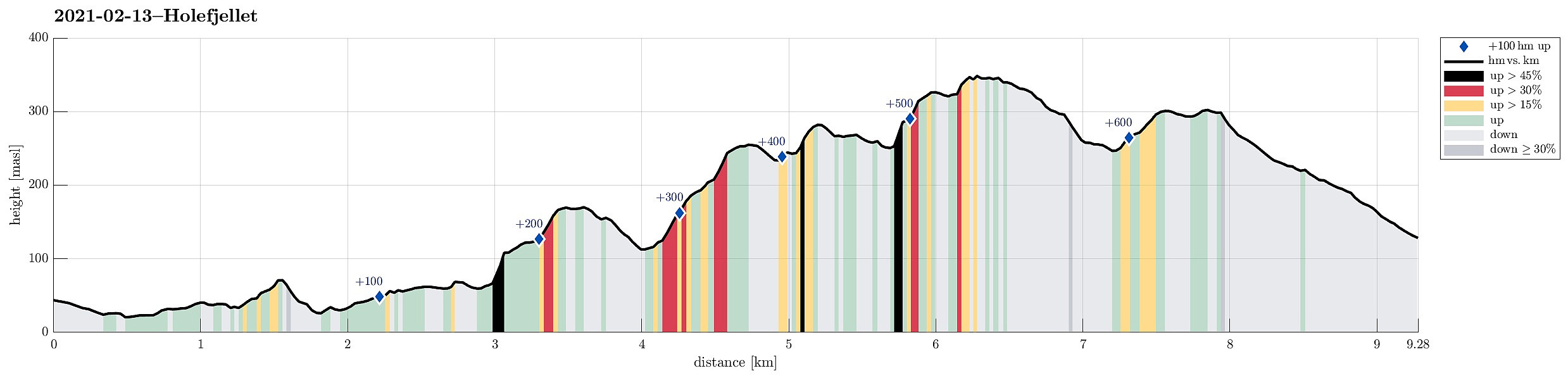 Expecting the unusually stable winter weather to end soon, we decided to get out and enjoy both sun and snow directly where we live, doing "nothing else" than a hike in Kanadaskogen. We started walking northwards from Varden, passing by Sælen church and crossing over the fotball fields in front of the FraMo sports hall, we continued into the direction of Hesjaholten, walking along the houses at Veslefrikkveien in their south. Surrounding Hesjaholten in its west (and below it, there), we entered the valley through which the waters from Krokatjørna come down as a little stream. Walking up this valley, we came to the somewhat more flat (and usually very wet) area in the west of Stora Krokatjørna. Enjoying some lovely sun and nice snow there, we walked across the (usually) boggy >>>
