Arkiv - dato
Arkiv - aktivitet
-
Annen tur (1)
- Kajakkpadling (1)
-
Annen vintertur (4)
- Trugetur (4)
- Fottur (740)
-
Skitur (4)
- Fjellskitur (4)
-
Sykkeltur (137)
- Blandet sykling (51)
- Gatesykling (9)
Arkiv - Etter geografi
"Peakbookvenner"


Lister jeg samler etter
-
Bergen ≥ 50m pf. og ≥ 100 m.o.h.
(87/89)
 97%
97% -
Most dominating tops of the Bergen peninsula
(68/75)
90%
-
Utvalgte topper og turmål i Bergen
(316/350)
90%
-
Alle topper i Bergen
(357/398)
89%
-
Opptur Bergen
(100/113)
88%
-
De syv fjell rundt Bergen
(6/7)
85%
-
Sund ≥ 50m pf.
(14/18)
77%
-
Os ≥ 50m pf.
(25/34)
73%
-
Søyler (fastmerker) i Bergen
(68/100)
68%
-
Fjell ≥ 50m pf.
(21/32)
65%

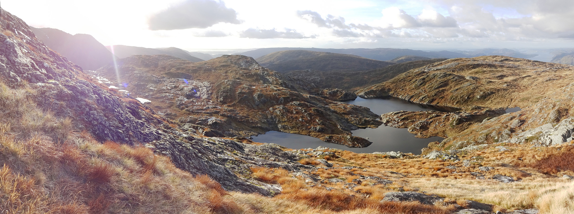
Livarden and Slettegga from Bontveit
- Dato:
- 31.10.2020
- Turtype:
- Fottur
- Turlengde:
- 3:30t
- Distanse:
- 10,8km
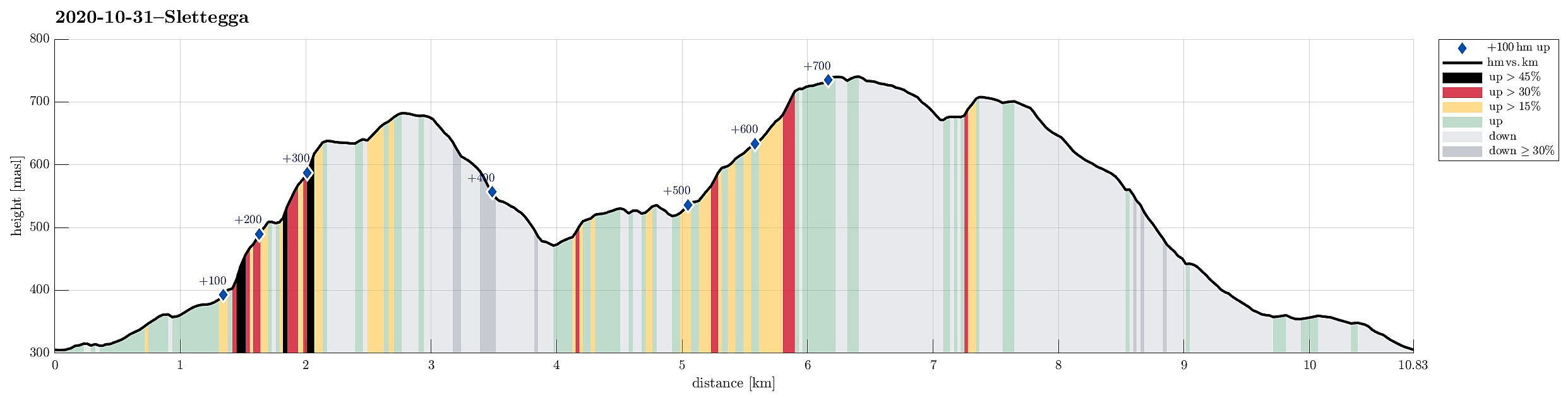 Expecting a couple of nice hours on this Saturday, we planned for a hike that was still on our "to-do list". Specifically, the idea was to combine an ascent to Livarden with one to Slettegga, connecting both via the saddle at Rambjørgvatnet. To do so, and to make this a nice round, we aimed at starting from Bontveit, ascending Livarden from there first (mostly without any trail), visiting Krokvatnet on our way, and then hike over to Slettegga. From there, our plan was to then return to Bontveit via Nobbane. And so we did it. :-)
Leaving Bergen southwards along E39, we turned left at Kalandsvatnet to drive road 5162 all the way up to Bontveit. At the highest point of this road (about 300mosl), before it starts winding down to Hausdalen in the south, we parked along with quite >>>
Expecting a couple of nice hours on this Saturday, we planned for a hike that was still on our "to-do list". Specifically, the idea was to combine an ascent to Livarden with one to Slettegga, connecting both via the saddle at Rambjørgvatnet. To do so, and to make this a nice round, we aimed at starting from Bontveit, ascending Livarden from there first (mostly without any trail), visiting Krokvatnet on our way, and then hike over to Slettegga. From there, our plan was to then return to Bontveit via Nobbane. And so we did it. :-)
Leaving Bergen southwards along E39, we turned left at Kalandsvatnet to drive road 5162 all the way up to Bontveit. At the highest point of this road (about 300mosl), before it starts winding down to Hausdalen in the south, we parked along with quite >>>
Gullfjelltoppen via Gulltjørna and Storegga
- Dato:
- 18.10.2020
- Turtype:
- Fottur
- Turlengde:
- 6:00t
- Distanse:
- 13,8km
 We looked forward to a cold but sunny autumn Sunday and thus planned a hike "with high expectations"! :-) While we had earlier hiked quite a bit "here and there" in the Gullfjellet area, we not yet had traversed Storegga (in the north of Gullfjelltoppen). Thus we had a plan! :-) To make this hike a nice round, we aimed to start at the saddle between Trengereiddalen and Gullbotn, then traverse (without a trail) to Gulltjørna, before then ascending Gråfjellet and from there Storegga. After that, our plan was to hike down the major trail between Gullfjelltoppen and Gullbotn.
We left Bergen to the East, following E16 from Arna until the roundabout near Trengereid, where we turned right (in southern direction). We then drove up Trengereiddalen until we came to the saddle >>>
We looked forward to a cold but sunny autumn Sunday and thus planned a hike "with high expectations"! :-) While we had earlier hiked quite a bit "here and there" in the Gullfjellet area, we not yet had traversed Storegga (in the north of Gullfjelltoppen). Thus we had a plan! :-) To make this hike a nice round, we aimed to start at the saddle between Trengereiddalen and Gullbotn, then traverse (without a trail) to Gulltjørna, before then ascending Gråfjellet and from there Storegga. After that, our plan was to hike down the major trail between Gullfjelltoppen and Gullbotn.
We left Bergen to the East, following E16 from Arna until the roundabout near Trengereid, where we turned right (in southern direction). We then drove up Trengereiddalen until we came to the saddle >>>
Short double-round in Milde
- Dato:
- 17.10.2020
- Turtype:
- Spasertur
- Turlengde:
- 1:30t
- Distanse:
- 4,7km
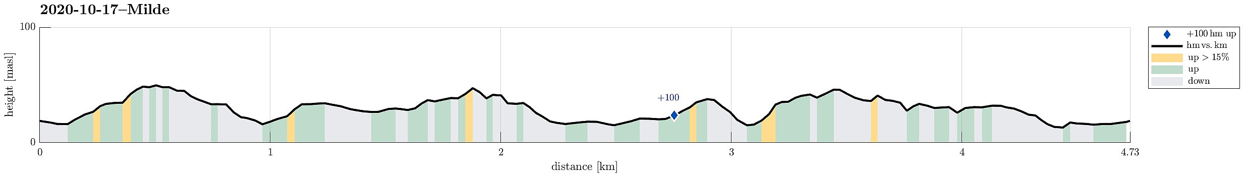 The weather forecast was not too good and also there were other things to do, so the decision was to do something near and quick. We drove south through Ytrebygda, crossing Flyplassvegen to continue further south, towards Milde, following road #573. Coming closer, one follows the signs to Arboretet i Milde. We parked near a Kindergarden along Mildevegen and started our walk in northeastern direction. Once in the green, we turned right and towards Nepegjerdhaugen, which is the highest "top" on the island. Then, we turned back into the forest and headed towards Arboretet. We then walked southwards along a nice trail on the western side of Arboretet. At Naustdalen, we turned right (and towards the school there). With a bit of left and right, we then ended up on Lysthushaugen >>>
Austlendingen
- Dato:
- 11.10.2020
- Turtype:
- Fottur
- Turlengde:
- 4:30t
- Distanse:
- 8,7km
 We left Bergen on E39 towards the north (Knarvik) and continued further on E39 in northeastern direction (north of Osterfjorden) after having past Knarvik. Right before we would have entered the long Eikefettunnelen, we turned left (onto road 570) and parked only meters after leaving road E39. Our main goal of the day was Austlendingen and we had thought to start along the main trail there, which starts just meters west of the entry to Eikefettunnelen (on the southern side of road E39). Our plan, as prepared at home, was to attempt a round (off trail up, on the main trail down), but when we came to the trail head, we encoutered a pretty bold sign informing everyone about the ongoing hunting period and that hikers should stay on marked trails. After a little bit of consideration, we decided >>>
Krampane and Hamlagrøhornet
- Dato:
- 04.10.2020
- Turtype:
- Fottur
- Turlengde:
- 4:00t
- Distanse:
- 9,6km
 The day after our hike to Kjerringafjellet , we again started from Hamlagrøvegen -- this time, however, into the other, northeastern direction. Our first goal was Krampane, north of the cabin named after Alexander Grieg at Holeberg. We first walked along the western slope of Røvhaugane, before then crossing over to Svartagrovi in northwestern direction. Just a few height meters below 700mosl, we crossed the stream and continued (for a not very long stretch) along the marked trail in northern direction. Roughly where we crossed 700mosl, we diverted from this trail to the left and continued (in northwestern direction) towards the southern ridge of Krampane. Just a bit above 800mosl, then, we had connected to that ridge and continued along it upwards (all the way to Krampane). Up there, we then enjoyed some really >>>
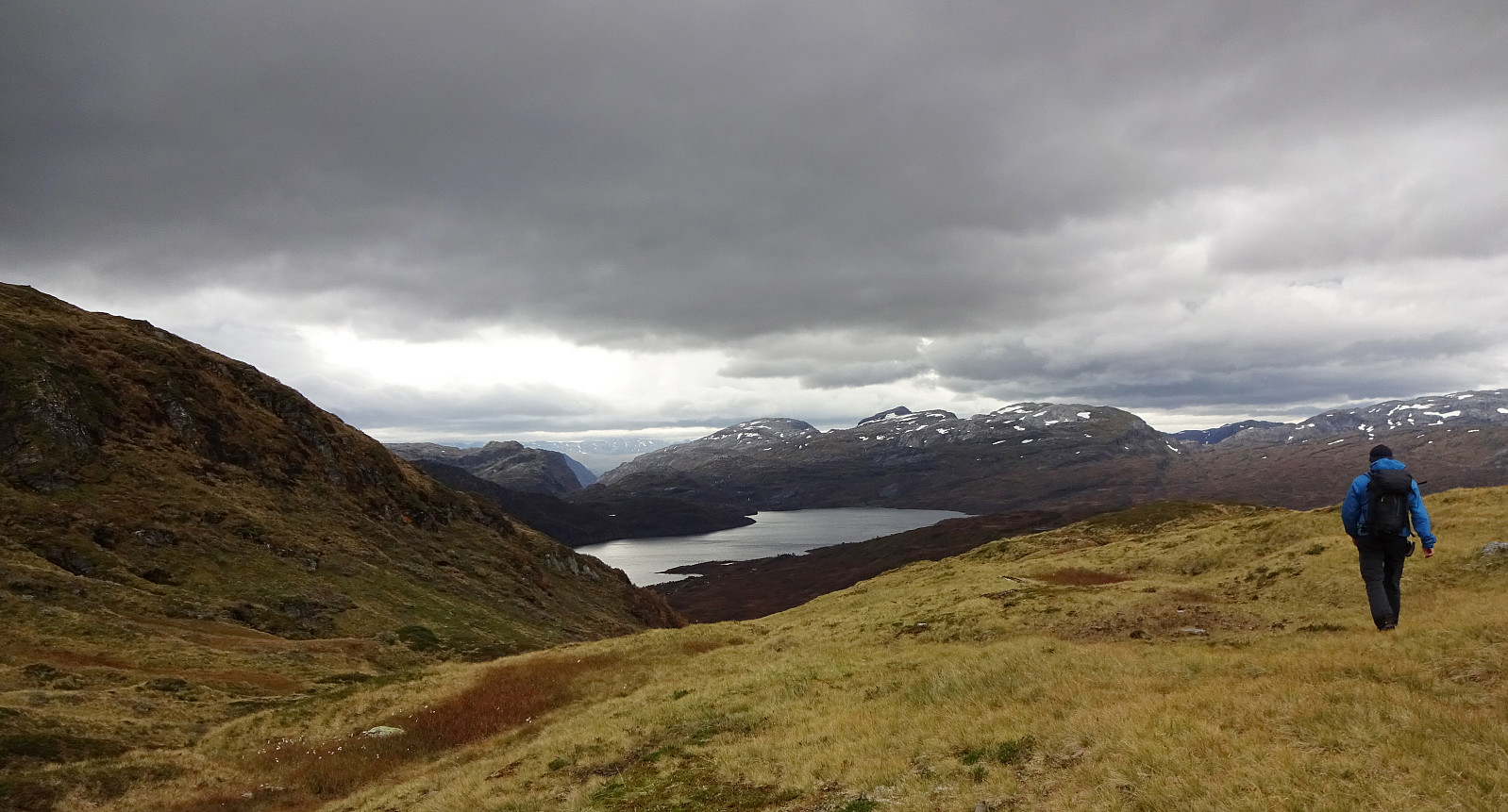
Kjerringafjellet
- Dato:
- 03.10.2020
- Turtype:
- Fottur
- Turlengde:
- 4:30t
- Distanse:
- 10,8km
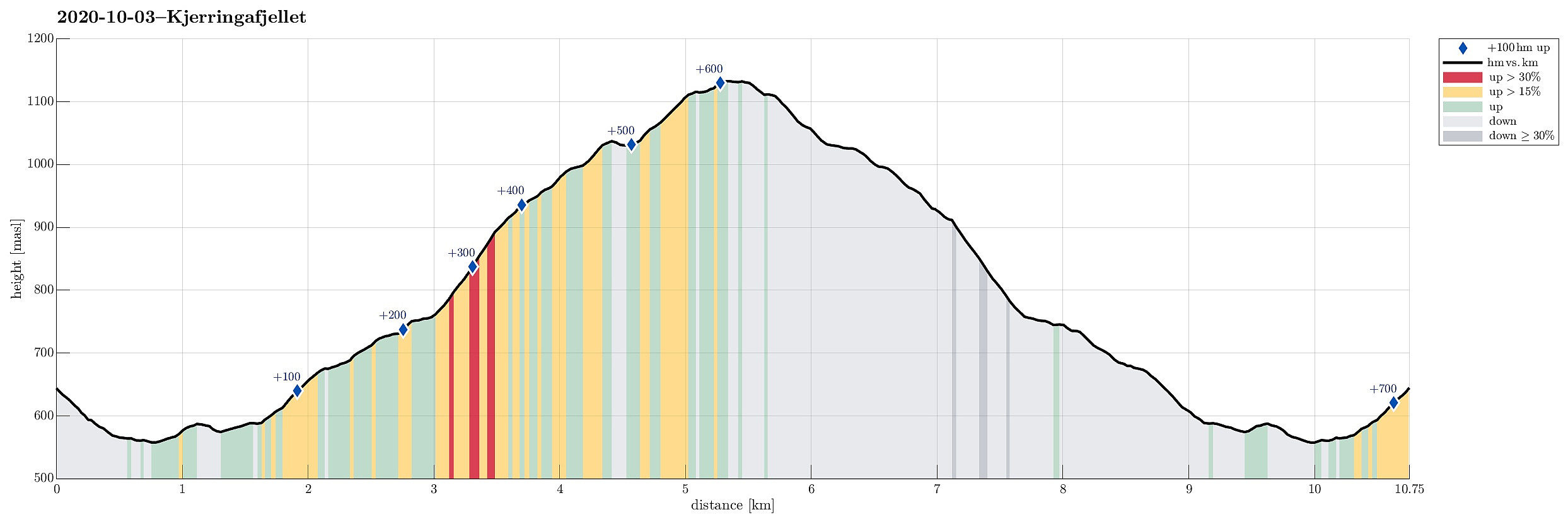 We drove from Bergen to Bergsdalen (via Dale) and parked right where the road through Bergsdalen crosses from Vaksdal district to Voss district. On the southwestern side of the road, we stepped off the parking lot and on to a trail that leads into the direction of Øvretjørni, leading through a field of cabins there. Surrounding Øvretjørni in its northwest, the trail then turns more into a southward direction, aiming for the saddle between Magneknolten and Kjerringafjellet. Once in the west of Magneknolten, the trail surrounds Rjupehaugane in their south until it brings one into a small valley that extens upwards to Hardingskaret in its northwest. Before actually getting there (Hardingskaret), one turns left, again, and towards Kjerringafjellet. A steadily ascending slope leads up to >>>
