Arkiv - dato
Arkiv - aktivitet
-
Annen tur (1)
- Kajakkpadling (1)
-
Annen vintertur (4)
- Trugetur (4)
- Fottur (740)
-
Skitur (4)
- Fjellskitur (4)
-
Sykkeltur (137)
- Blandet sykling (51)
- Gatesykling (9)
Arkiv - Etter geografi
"Peakbookvenner"


Lister jeg samler etter
-
Bergen ≥ 50m pf. og ≥ 100 m.o.h.
(87/89)
 97%
97% -
Most dominating tops of the Bergen peninsula
(68/75)
90%
-
Utvalgte topper og turmål i Bergen
(316/350)
90%
-
Alle topper i Bergen
(357/398)
89%
-
Opptur Bergen
(100/113)
88%
-
De syv fjell rundt Bergen
(6/7)
85%
-
Sund ≥ 50m pf.
(14/18)
77%
-
Os ≥ 50m pf.
(25/34)
73%
-
Søyler (fastmerker) i Bergen
(68/100)
68%
-
Fjell ≥ 50m pf.
(21/32)
65%

Hovdane from Brattholo
- Dato:
- 08.08.2020
- Turtype:
- Fjelltur
- Turlengde:
- 4:00t
- Distanse:
- 6,4km
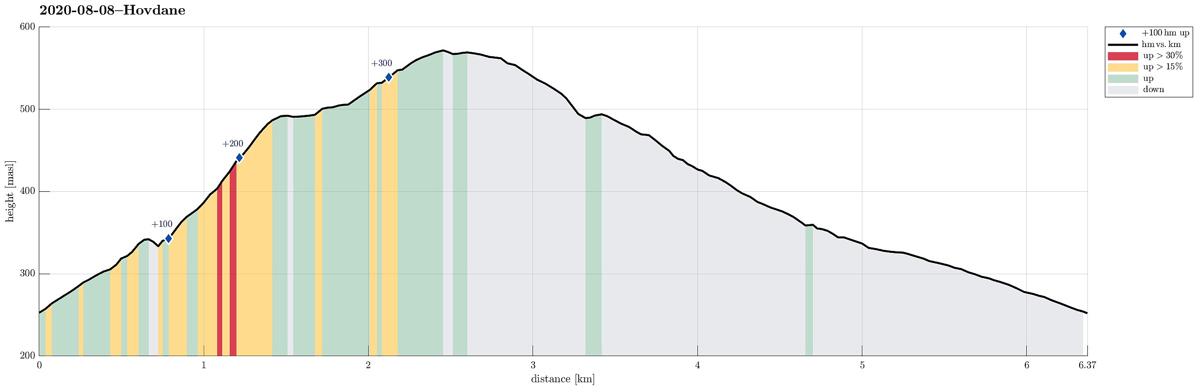 With a somewhat unclear weather forecast, we aimed at something gentle, not too far up. Driving along E16 (into the direction of Voss), we left the main road a little southwest of Vinje, contiuning for bit into the direction of Hommedalen. Driving up Holbygdvegen to about 250mosl, we found a suitable place near Brattholo to park right next to the road. From there, we started walking along a minor road that winds up towards the eastern flank of Hagahovden. A little over 300mosl then, we left the road (basically where it ends) and continued along a trail that continues further upwards. At about 335mosl, we briefly explored a flag post with some view, before soon returning to the trail and following further upwards. At about 500mosl we then arrived at a nice shelter at Hovdane, enjoying >>>
Skarsnosi from Jordalen
- Dato:
- 07.08.2020
- Turtype:
- Fottur
- Turlengde:
- 5:00t
- Distanse:
- 10,1km
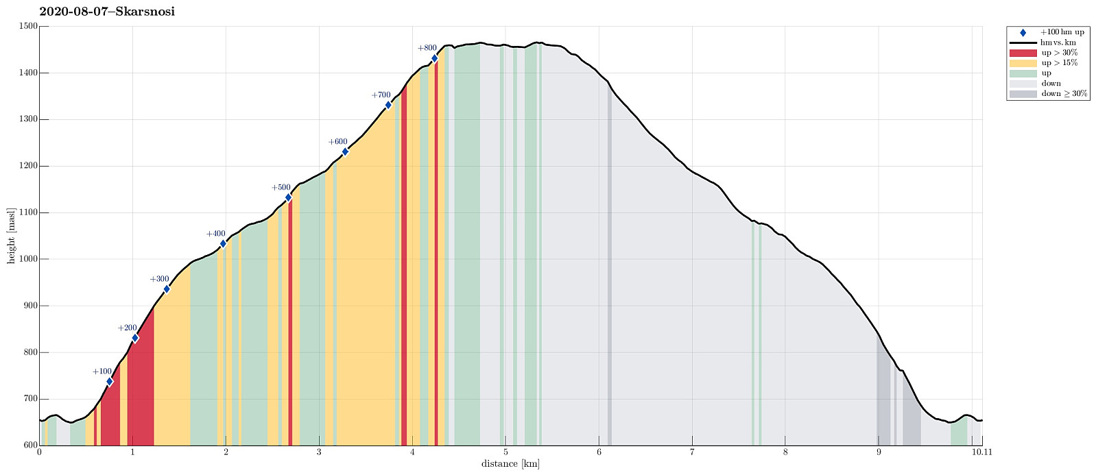 We expected a nice day and thought about Bakkanosi, since we had not been there before. Looking down onto Nærøyfjorden from this place sounds like a worthwhile experience! We thus drove along E16 into the direction of Gudvangen, passing by Stalheim. Quite a bit down in Nærøydalen, we then turned left and used the new tunnel up to Jordalen. Not far up in Jordalen, where Slettedalen comes down from the East, one would park to start the "standard hike" to Bakkanosi (through Slettedalen). Coming there, we were shocked about the relatively large number of parked cars and immediately changed our plan. Instead of Bakkanosi, we now planned for Skarsnosi, not far from Bakkanosi. To get up there, we had thought to hike up the next valley (north of Slettedalen). To do so, we drove >>>
Tverrfjellet from Bidne
- Dato:
- 06.08.2020
- Turtype:
- Fottur
- Turlengde:
- 5:00t
- Distanse:
- 13,6km
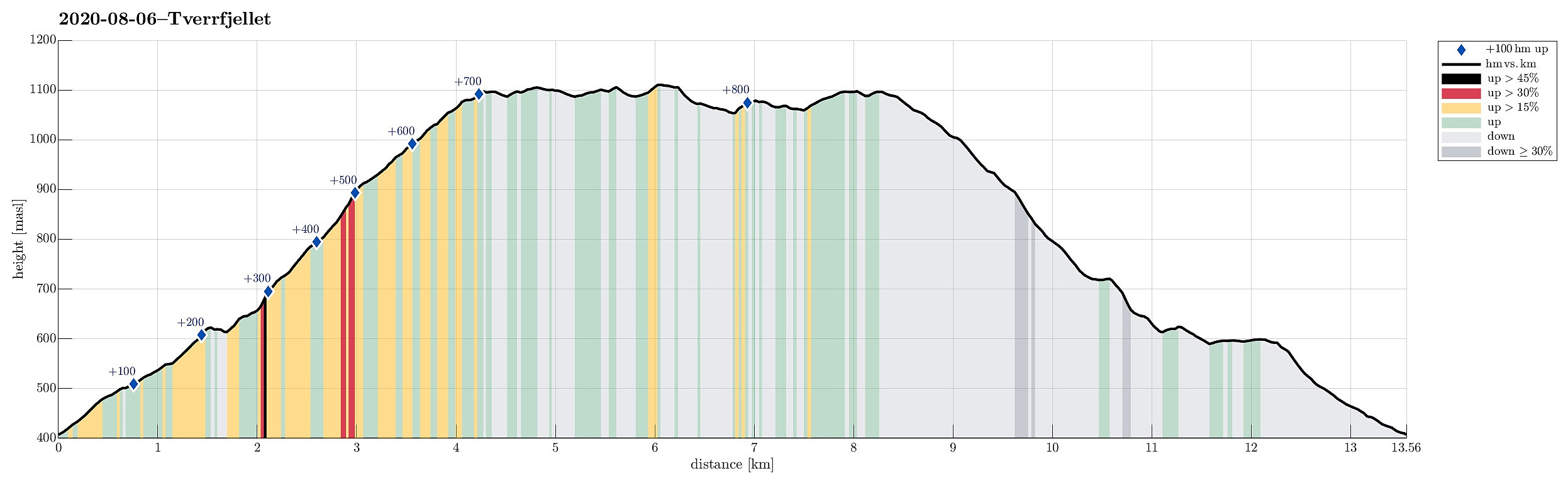 The weather forecast was moderately OK (quite a bit overcast with realistic chances for some rain), so we aimed for a moderate hike, bringing us not too high up (and into the clouds). Since we had not been there before and expected at least some nice views from up there, our choice was to hike up to Tverrfjellet from Oppheim. We thus drove to Oppheim first and then left the main road (E16) near Framnes to drive up a simple road into the direction of Bidne. A few meters after reaching Bidne (that's about one kilometer from E16), we turned right (eastwards) and drove a few meters more towards Bidneshovden. There, we parked and started our hike (in northern direction, on a forest road). We followed the forest road northwards, staying on the western side of Sundsvålselvi, steadily ascending >>>
Mor Si Grav (and Bergshaugen)
- Dato:
- 05.08.2020
- Turtype:
- Fjelltur
- Turlengde:
- 1:30t
- Distanse:
- 4,9km
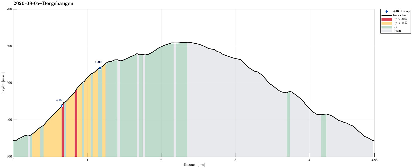 Again and again we had passed by (without stopping) before, so this time, on a rainy day, we decided to stop and take look at "Mor Si Grav" in Oppheim. We parked near the church and walked the few meters up to the old graveyard, where only "Mor Si Grav" (the mother's grave) remains. It's the place where the mother of Per Sivle is buried and an info plate not far from the grave explains some of the (quite moving!) history around it. After taking our time there, we then appended a little round around Bergshaugen, walking first up the hill and then over (at about 550mosl) to Uresåsen. From there, we then followed a gravel road (behind Bergshaugen) to Kvernhusholene. From there, we started our descent, first on the right (northern) side of Gryteelvi. At about 475mosl, >>>
Okslevarden
- Dato:
- 01.08.2020
- Turtype:
- Fottur
- Turlengde:
- 6:00t
- Distanse:
- 9,7km
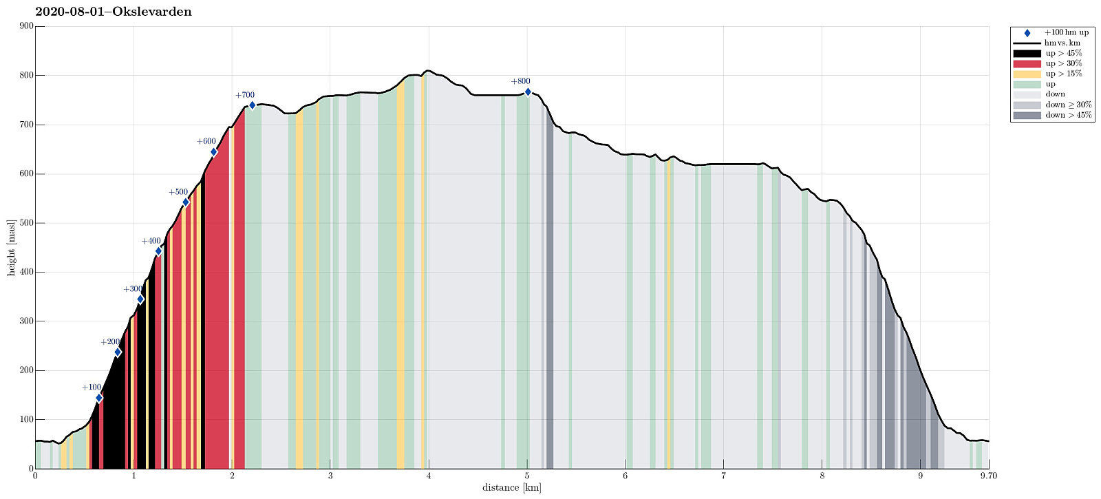 When staying over night in Haugsvær, we were recommended to ascend to Gråsida from Indre Haugsdal. So that's what we did then! :-) We drove road E39 "back" south (into the direction of Bergen) and turned right in Matre (to leave E39 before entering Masfjordtunnelen). This brought us onto the old road and following it we entered Indre Haugsdal from Haugsdalvågen. Driving up this nice valley, we came by three particular hills (in the middle of the valley), which possibly gave the valley its name. Near Kjetland we crossed the river on an old stone bridge, turning right (into the direction of Storemyr) right after the bridge. Since we did not see any particular good parking opportunity next to this narrow road, we drove all the way to Storemyr and asked there. Luckily, we were >>>
