Archiv - Nach Datum
Archiv - Nach Aktivität
-
Andere Tour (1)
- Kayaking (1)
-
Andere Wintertour (4)
- Schneeschuhtour (4)
-
Fahrradtour (137)
- Fahrradtour Straße (9)
- Fahrradtour gemischt (51)
-
Fußtour (740)
- Bergtour (363)
- Jogging (18)
- Spaziergang (89)
- Wanderung (270)
-
Skitour (4)
- Tourenskilauf (4)
Archiv - Nach Geografie
Peakbookfreunde


Gesammelte Listen
-
Bergen ≥ 50m pf. og ≥ 100 m.o.h.
(87/89)
 97%
97% -
Most dominating tops of the Bergen peninsula
(68/75)
90%
-
Utvalgte topper og turmål i Bergen
(316/350)
90%
-
Alle topper i Bergen
(357/398)
89%
-
Opptur Bergen
(100/113)
88%
-
De syv fjell rundt Bergen
(6/7)
85%
-
Sund ≥ 50m pf.
(14/18)
77%
-
Os ≥ 50m pf.
(25/34)
73%
-
Søyler (fastmerker) i Bergen
(68/100)
68%
-
Fjell ≥ 50m pf.
(21/32)
65%

Gullfjelltoppen via Gulltjørna and Storegga
- Datum:
- 18.10.2020
- Tourcharakter:
- Wanderung
- Tourlänge:
- 6:00h
- Entfernung:
- 13,8km
 We looked forward to a cold but sunny autumn Sunday and thus planned a hike "with high expectations"! :-) While we had earlier hiked quite a bit "here and there" in the Gullfjellet area, we not yet had traversed Storegga (in the north of Gullfjelltoppen). Thus we had a plan! :-) To make this hike a nice round, we aimed to start at the saddle between Trengereiddalen and Gullbotn, then traverse (without a trail) to Gulltjørna, before then ascending Gråfjellet and from there Storegga. After that, our plan was to hike down the major trail between Gullfjelltoppen and Gullbotn.
We left Bergen to the East, following E16 from Arna until the roundabout near Trengereid, where we turned right (in southern direction). We then drove up Trengereiddalen until we came to the saddle >>>
We looked forward to a cold but sunny autumn Sunday and thus planned a hike "with high expectations"! :-) While we had earlier hiked quite a bit "here and there" in the Gullfjellet area, we not yet had traversed Storegga (in the north of Gullfjelltoppen). Thus we had a plan! :-) To make this hike a nice round, we aimed to start at the saddle between Trengereiddalen and Gullbotn, then traverse (without a trail) to Gulltjørna, before then ascending Gråfjellet and from there Storegga. After that, our plan was to hike down the major trail between Gullfjelltoppen and Gullbotn.
We left Bergen to the East, following E16 from Arna until the roundabout near Trengereid, where we turned right (in southern direction). We then drove up Trengereiddalen until we came to the saddle >>>
Short double-round in Milde
- Datum:
- 17.10.2020
- Tourcharakter:
- Spaziergang
- Tourlänge:
- 1:30h
- Entfernung:
- 4,7km
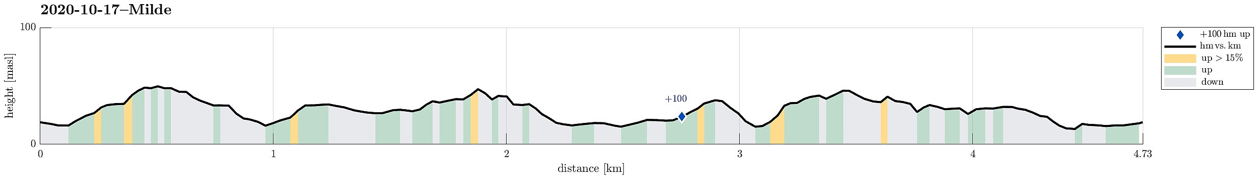 The weather forecast was not too good and also there were other things to do, so the decision was to do something near and quick. We drove south through Ytrebygda, crossing Flyplassvegen to continue further south, towards Milde, following road #573. Coming closer, one follows the signs to Arboretet i Milde. We parked near a Kindergarden along Mildevegen and started our walk in northeastern direction. Once in the green, we turned right and towards Nepegjerdhaugen, which is the highest "top" on the island. Then, we turned back into the forest and headed towards Arboretet. We then walked southwards along a nice trail on the western side of Arboretet. At Naustdalen, we turned right (and towards the school there). With a bit of left and right, we then ended up on Lysthushaugen >>>
Austlendingen
- Datum:
- 11.10.2020
- Tourcharakter:
- Wanderung
- Tourlänge:
- 4:30h
- Entfernung:
- 8,7km
 We left Bergen on E39 towards the north (Knarvik) and continued further on E39 in northeastern direction (north of Osterfjorden) after having past Knarvik. Right before we would have entered the long Eikefettunnelen, we turned left (onto road 570) and parked only meters after leaving road E39. Our main goal of the day was Austlendingen and we had thought to start along the main trail there, which starts just meters west of the entry to Eikefettunnelen (on the southern side of road E39). Our plan, as prepared at home, was to attempt a round (off trail up, on the main trail down), but when we came to the trail head, we encoutered a pretty bold sign informing everyone about the ongoing hunting period and that hikers should stay on marked trails. After a little bit of consideration, we decided >>>
Krampane and Hamlagrøhornet
- Datum:
- 04.10.2020
- Tourcharakter:
- Wanderung
- Tourlänge:
- 4:00h
- Entfernung:
- 9,6km
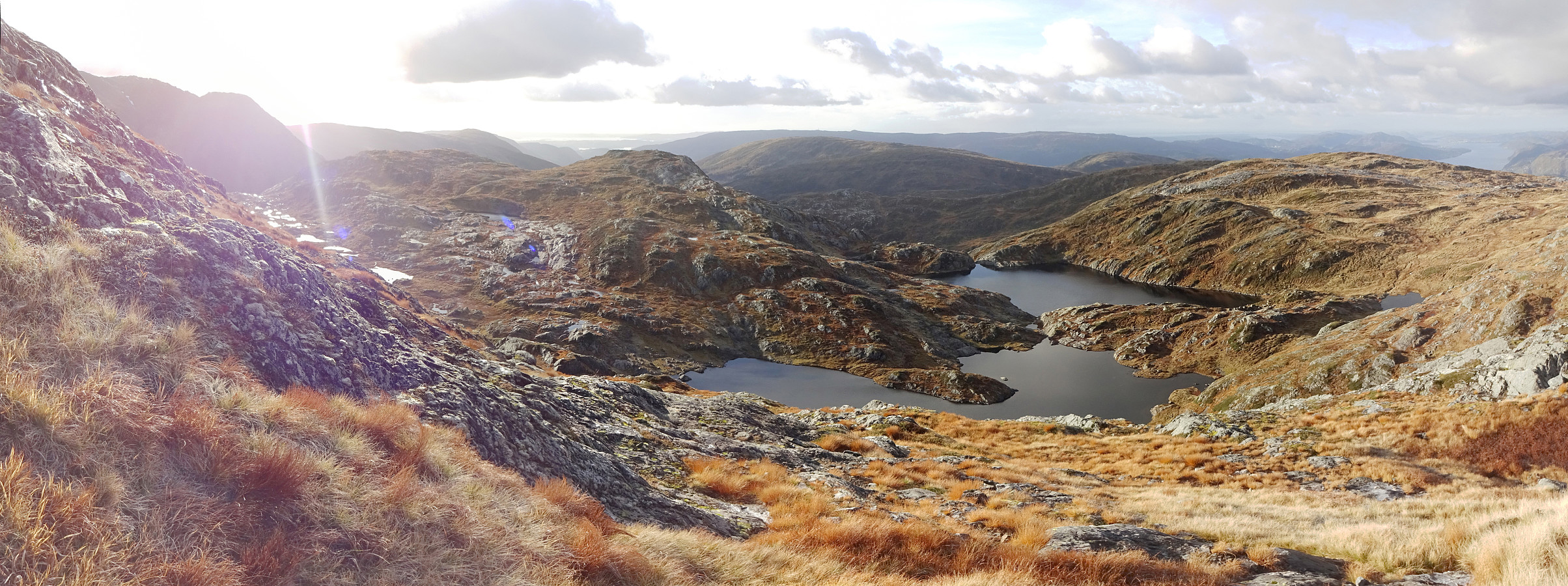
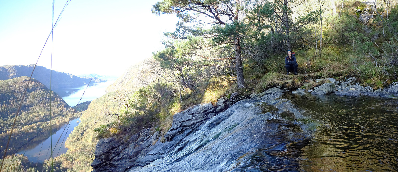
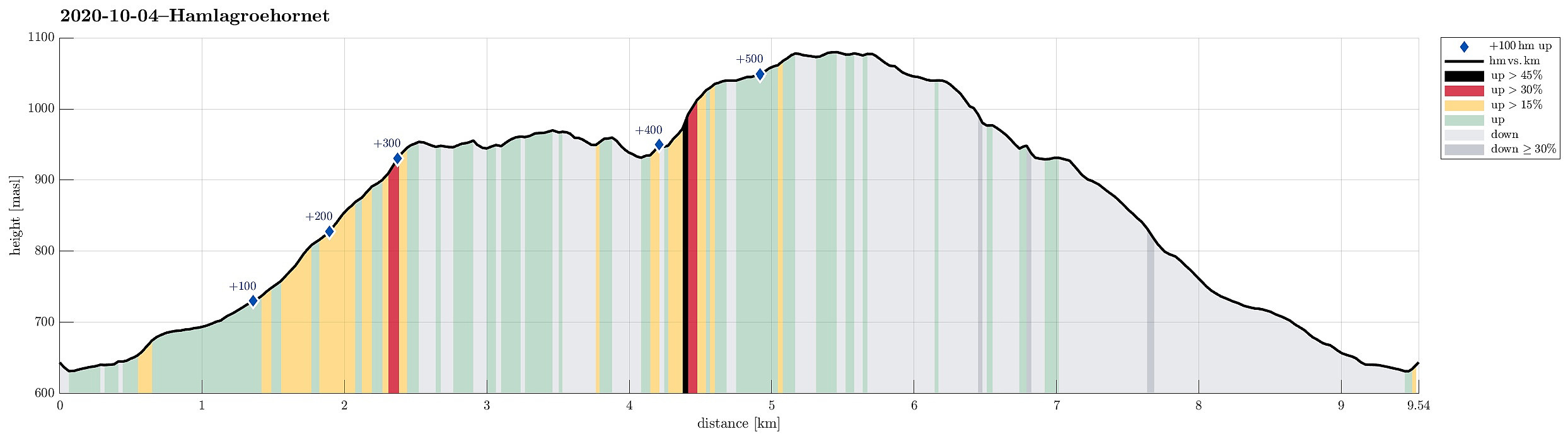 The day after our hike to Kjerringafjellet , we again started from Hamlagrøvegen -- this time, however, into the other, northeastern direction. Our first goal was Krampane, north of the cabin named after Alexander Grieg at Holeberg. We first walked along the western slope of Røvhaugane, before then crossing over to Svartagrovi in northwestern direction. Just a few height meters below 700mosl, we crossed the stream and continued (for a not very long stretch) along the marked trail in northern direction. Roughly where we crossed 700mosl, we diverted from this trail to the left and continued (in northwestern direction) towards the southern ridge of Krampane. Just a bit above 800mosl, then, we had connected to that ridge and continued along it upwards (all the way to Krampane). Up there, we then enjoyed some really >>>
Kjerringafjellet
- Datum:
- 03.10.2020
- Tourcharakter:
- Wanderung
- Tourlänge:
- 4:30h
- Entfernung:
- 10,8km
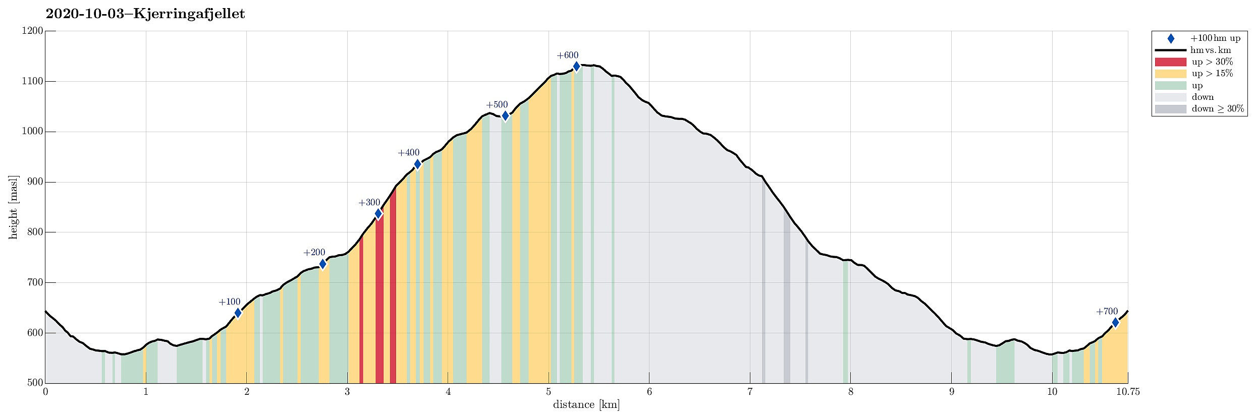 We drove from Bergen to Bergsdalen (via Dale) and parked right where the road through Bergsdalen crosses from Vaksdal district to Voss district. On the southwestern side of the road, we stepped off the parking lot and on to a trail that leads into the direction of Øvretjørni, leading through a field of cabins there. Surrounding Øvretjørni in its northwest, the trail then turns more into a southward direction, aiming for the saddle between Magneknolten and Kjerringafjellet. Once in the west of Magneknolten, the trail surrounds Rjupehaugane in their south until it brings one into a small valley that extens upwards to Hardingskaret in its northwest. Before actually getting there (Hardingskaret), one turns left, again, and towards Kjerringafjellet. A steadily ascending slope leads up to >>>
Rundehaugen from Fjæreide
- Datum:
- 27.09.2020
- Tourcharakter:
- Bergtour
- Tourlänge:
- 4:30h
- Entfernung:
- 9,7km
 Since we expected the afternoon to be substantially cloudy, we decided to make a hike in the lowlands rather than up on some tops (and in the clouds). Since we had not yet explored this region in detail, we chose to start at Fjæreide (in the west of Knappskog on Sotra) and then aim for Rundehaugen (in the east of Skålvik). After driving along road 555 westwards to Sotra and then northwards (road 561), one comes to Knappskog. There, one can turn left (westwards, again) and follow a narrow road to Fjæreide, where there's ample space for parking next to the road (they may have had, or still have, plans to broaden this road, leaving quite a bit of not yet used space besides the road). At the southern-most point (in Fjæreide) the road crosses over a small valley in a large turn to the right. >>>
Krånipa, Raudnipa, and Hananipa (from Gullbotn)
- Datum:
- 19.09.2020
- Tourcharakter:
- Wanderung
- Tourlänge:
- 7:30h
- Entfernung:
- 17,7km
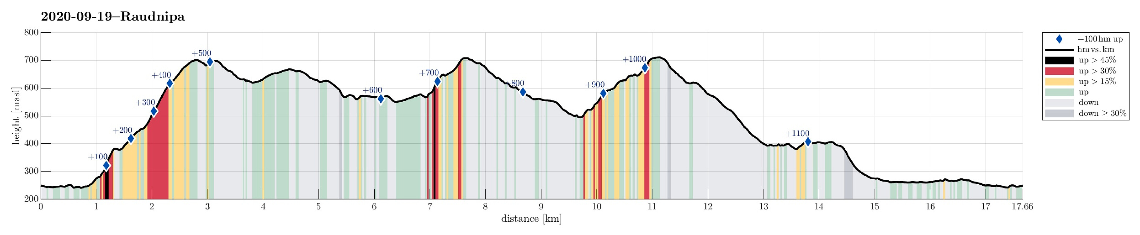 After a quite rainy period, we looked forward to a weekend with some nice weather. After weighing several hiking ideas against each other, we settled on a slightly longer hike over three Nipa-mountains in the East of Gullbotn. Driving along E16 from Arna, we turned right and up towards Gullbotn near Trengereid. Once above the saddle, we left the road at Gullbotn and parked right there (quite a number of parking places there). According to our plan (Krånipa first), we first headed in northern direction to get around Øyjordsvatnet. Almost exactly where Teinelva enters Øyjordsvatnet, we used a convenient bridge for pedestrians to get over to the other, eastern side. There, we turned left, again, to head for a small valley that runs south-north in the west of Skåpet. While passing by >>>
Hovdane from Brattholo
- Datum:
- 08.08.2020
- Tourcharakter:
- Bergtour
- Tourlänge:
- 4:00h
- Entfernung:
- 6,4km
 With a somewhat unclear weather forecast, we aimed at something gentle, not too far up. Driving along E16 (into the direction of Voss), we left the main road a little southwest of Vinje, contiuning for bit into the direction of Hommedalen. Driving up Holbygdvegen to about 250mosl, we found a suitable place near Brattholo to park right next to the road. From there, we started walking along a minor road that winds up towards the eastern flank of Hagahovden. A little over 300mosl then, we left the road (basically where it ends) and continued along a trail that continues further upwards. At about 335mosl, we briefly explored a flag post with some view, before soon returning to the trail and following further upwards. At about 500mosl we then arrived at a nice shelter at Hovdane, enjoying >>>
Skarsnosi from Jordalen
- Datum:
- 07.08.2020
- Tourcharakter:
- Wanderung
- Tourlänge:
- 5:00h
- Entfernung:
- 10,1km
 We expected a nice day and thought about Bakkanosi, since we had not been there before. Looking down onto Nærøyfjorden from this place sounds like a worthwhile experience! We thus drove along E16 into the direction of Gudvangen, passing by Stalheim. Quite a bit down in Nærøydalen, we then turned left and used the new tunnel up to Jordalen. Not far up in Jordalen, where Slettedalen comes down from the East, one would park to start the "standard hike" to Bakkanosi (through Slettedalen). Coming there, we were shocked about the relatively large number of parked cars and immediately changed our plan. Instead of Bakkanosi, we now planned for Skarsnosi, not far from Bakkanosi. To get up there, we had thought to hike up the next valley (north of Slettedalen). To do so, we drove >>>
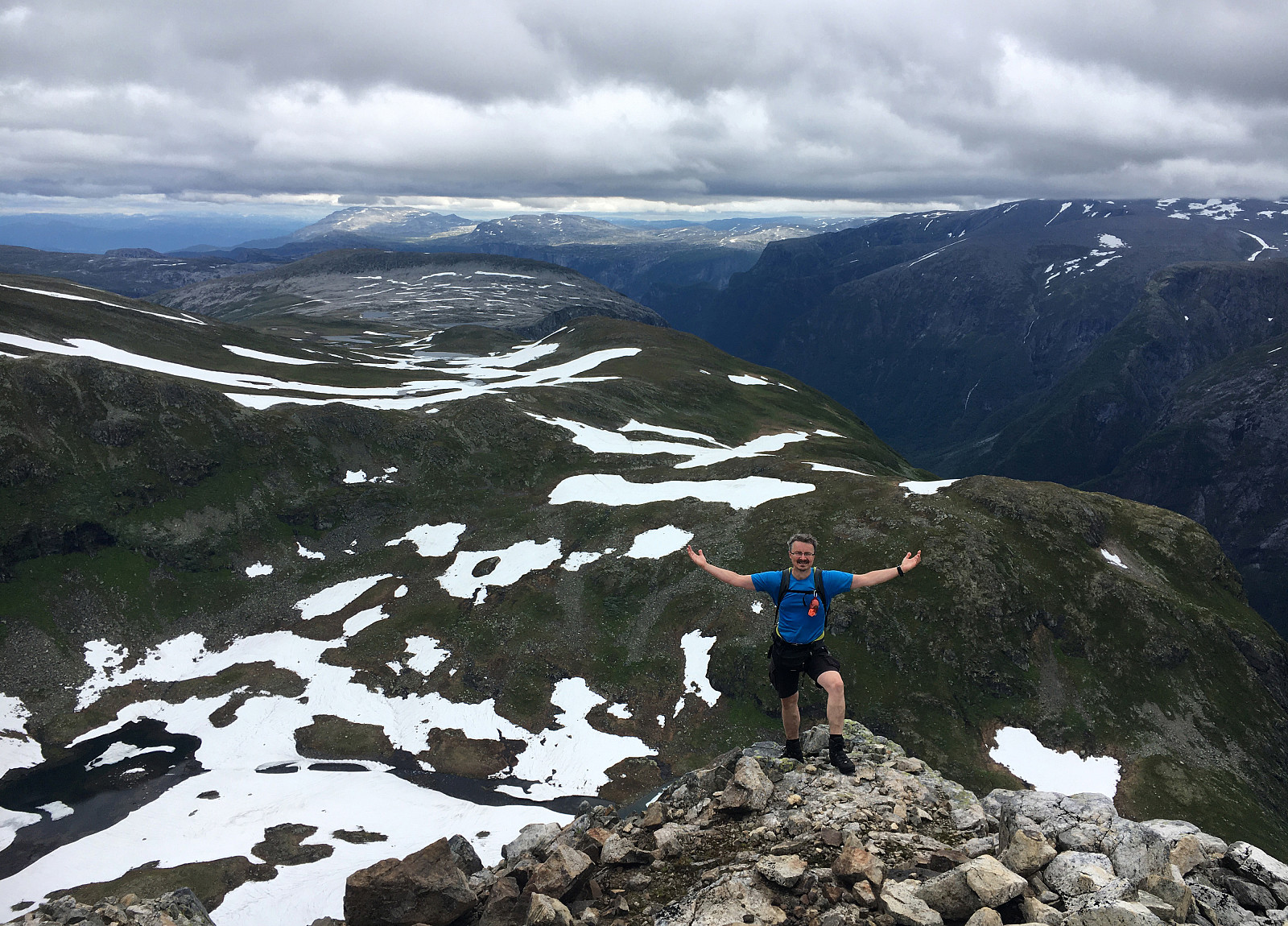
Tverrfjellet from Bidne
- Datum:
- 06.08.2020
- Tourcharakter:
- Wanderung
- Tourlänge:
- 5:00h
- Entfernung:
- 13,6km
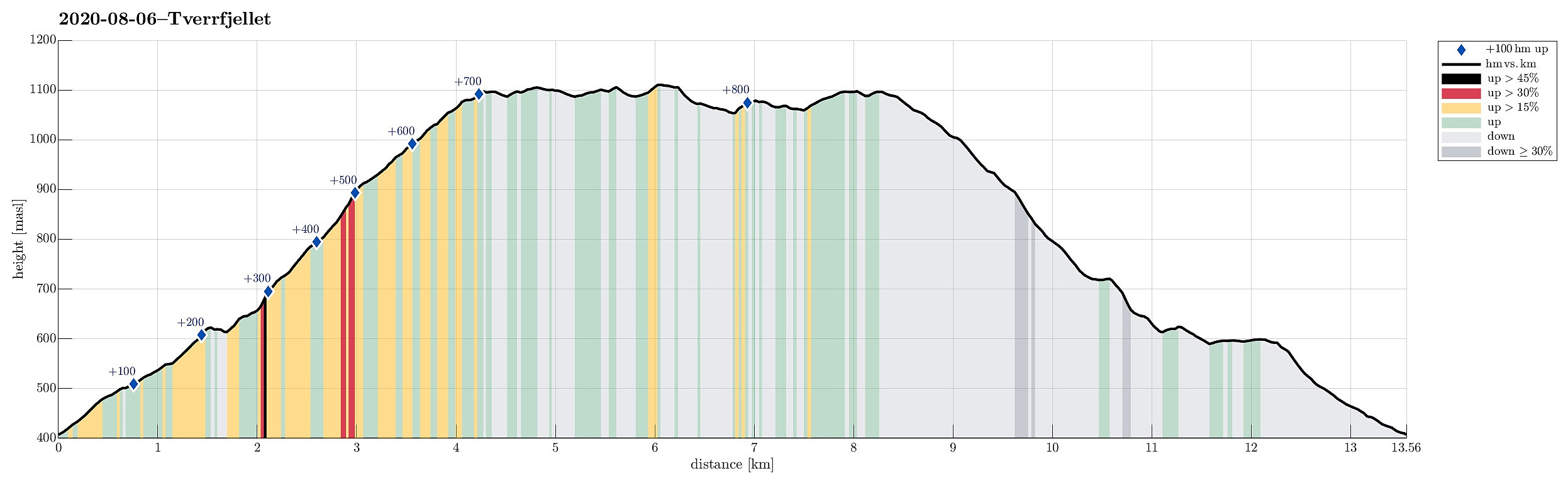 The weather forecast was moderately OK (quite a bit overcast with realistic chances for some rain), so we aimed for a moderate hike, bringing us not too high up (and into the clouds). Since we had not been there before and expected at least some nice views from up there, our choice was to hike up to Tverrfjellet from Oppheim. We thus drove to Oppheim first and then left the main road (E16) near Framnes to drive up a simple road into the direction of Bidne. A few meters after reaching Bidne (that's about one kilometer from E16), we turned right (eastwards) and drove a few meters more towards Bidneshovden. There, we parked and started our hike (in northern direction, on a forest road). We followed the forest road northwards, staying on the western side of Sundsvålselvi, steadily ascending >>>
