Arkiv - dato
Arkiv - aktivitet
-
Annen tur (1)
- Kajakkpadling (1)
-
Annen vintertur (4)
- Trugetur (4)
- Fottur (740)
-
Skitur (4)
- Fjellskitur (4)
-
Sykkeltur (137)
- Blandet sykling (51)
- Gatesykling (9)
Arkiv - Etter geografi
"Peakbookvenner"


Lister jeg samler etter
-
Bergen ≥ 50m pf. og ≥ 100 m.o.h.
(87/89)
 97%
97% -
Most dominating tops of the Bergen peninsula
(68/75)
90%
-
Utvalgte topper og turmål i Bergen
(316/350)
90%
-
Alle topper i Bergen
(357/398)
89%
-
Opptur Bergen
(100/113)
88%
-
De syv fjell rundt Bergen
(6/7)
85%
-
Sund ≥ 50m pf.
(14/18)
77%
-
Os ≥ 50m pf.
(25/34)
73%
-
Søyler (fastmerker) i Bergen
(68/100)
68%
-
Fjell ≥ 50m pf.
(21/32)
65%

Skarsnuten, Vardafjellet, Grytefjellet, and Belgjaråsen
- Dato:
- 30.04.2019
- Turtype:
- Fjelltur
- Turlengde:
- 5:45t
- Distanse:
- 14,8km
 After a meeting at Solstrand Bad & Hotel, we decided to do a hike in nearby Fuse before heading back to Bergen. From Hattvik, we thus took the ferry over to Venjaneset and drove from there further along road 552 towards Eikelandsosen. There we took to the left (onto road 48 and into the direction of Samnanger) and continued on it for a few kilometers (until we had come through Moshovdatunnelen). Right after the tunnel, we turned right (onto Hafskorvegen) and parked soon after (very near to the bridge that we had just passed over after the tunnel).
Our first hiking goal was Skarsnuten, a little top "in the valley", south of Hafskorvatnet. It was nice that we could see the top from the very start of the hike, also. We first followed the little road that leads up to Hafskorvatnet, >>>
After a meeting at Solstrand Bad & Hotel, we decided to do a hike in nearby Fuse before heading back to Bergen. From Hattvik, we thus took the ferry over to Venjaneset and drove from there further along road 552 towards Eikelandsosen. There we took to the left (onto road 48 and into the direction of Samnanger) and continued on it for a few kilometers (until we had come through Moshovdatunnelen). Right after the tunnel, we turned right (onto Hafskorvegen) and parked soon after (very near to the bridge that we had just passed over after the tunnel).
Our first hiking goal was Skarsnuten, a little top "in the valley", south of Hafskorvatnet. It was nice that we could see the top from the very start of the hike, also. We first followed the little road that leads up to Hafskorvatnet, >>>
Knappen
- Dato:
- 22.04.2019
- Turtype:
- Fjelltur
- Turlengde:
- 2:00t
- Distanse:
- 4,6km
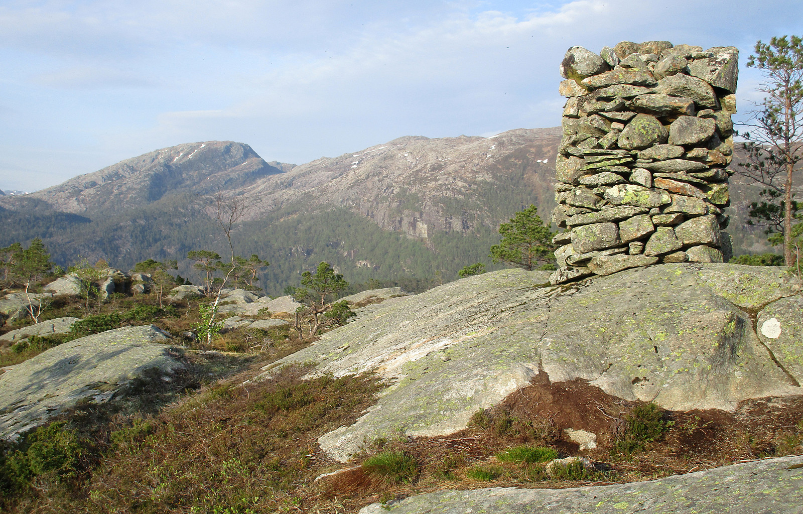
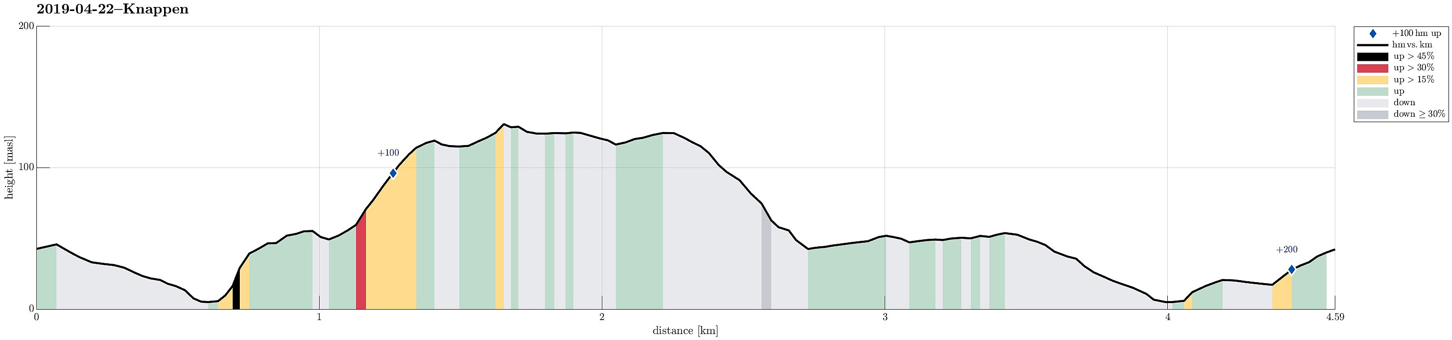 We started from Varden, crossing over Bjørgeveien near Sandeidet Terminal, and taking up the stairs to Vassteigen. We then took the trail that starts north of Knappatjørna and leads (more or less) directly up to Knappen (not including Eldtona, this time). At Knappen, we this time explored the southern side (towards Hesthaugen) and found an interesting spot there with a nice view towards the west (and over Maggevika). We then returned via Knappatjørna, where we enjoyed nice spring weather for a while, to Varden. Good to have Knappen nearby, when time is short, and there's still a wish to get some fresh air! :-)
See also the related FB-page Hiking around Bergen, Norway .
Petter Bjørstad has a useful page about Knappen .
We started from Varden, crossing over Bjørgeveien near Sandeidet Terminal, and taking up the stairs to Vassteigen. We then took the trail that starts north of Knappatjørna and leads (more or less) directly up to Knappen (not including Eldtona, this time). At Knappen, we this time explored the southern side (towards Hesthaugen) and found an interesting spot there with a nice view towards the west (and over Maggevika). We then returned via Knappatjørna, where we enjoyed nice spring weather for a while, to Varden. Good to have Knappen nearby, when time is short, and there's still a wish to get some fresh air! :-)
See also the related FB-page Hiking around Bergen, Norway .
Petter Bjørstad has a useful page about Knappen .
Ulriken from Haukeland Hospital (stone steps up)
- Dato:
- 20.04.2019
- Turtype:
- Fjelltur
- Turlengde:
- 3:00t
- Distanse:
- 7,1km
 We started from a bus stop at Haukeland University Hospital and first walked up the street to the lower station of the cable car that goes up to the top of Ulriken. Instead of taking the cable car, however, we followed a trail that leads up to Montana (and from there further towards Ulriken etc.). Once above the Montana Vandrerhjem, we followed the gravel road Johan Blytts vei, which ascends diagonally in southeastern direction, before it crosses a little stream. From there, it's getting steeper and shortly after, a renewed path turns left (from there then steeply upwards in northeastern direction). Before eventually departing from the gravel road (near Hellerane), the path gets once again very near to it (at about 325mosl). From there onward, it then goes steeply upwards (through Lægdebotn >>>
Fløyen from Bergen harbor
- Dato:
- 19.04.2019
- Turtype:
- Fjelltur
- Turlengde:
- 1:00t
- Distanse:
- 3,0km
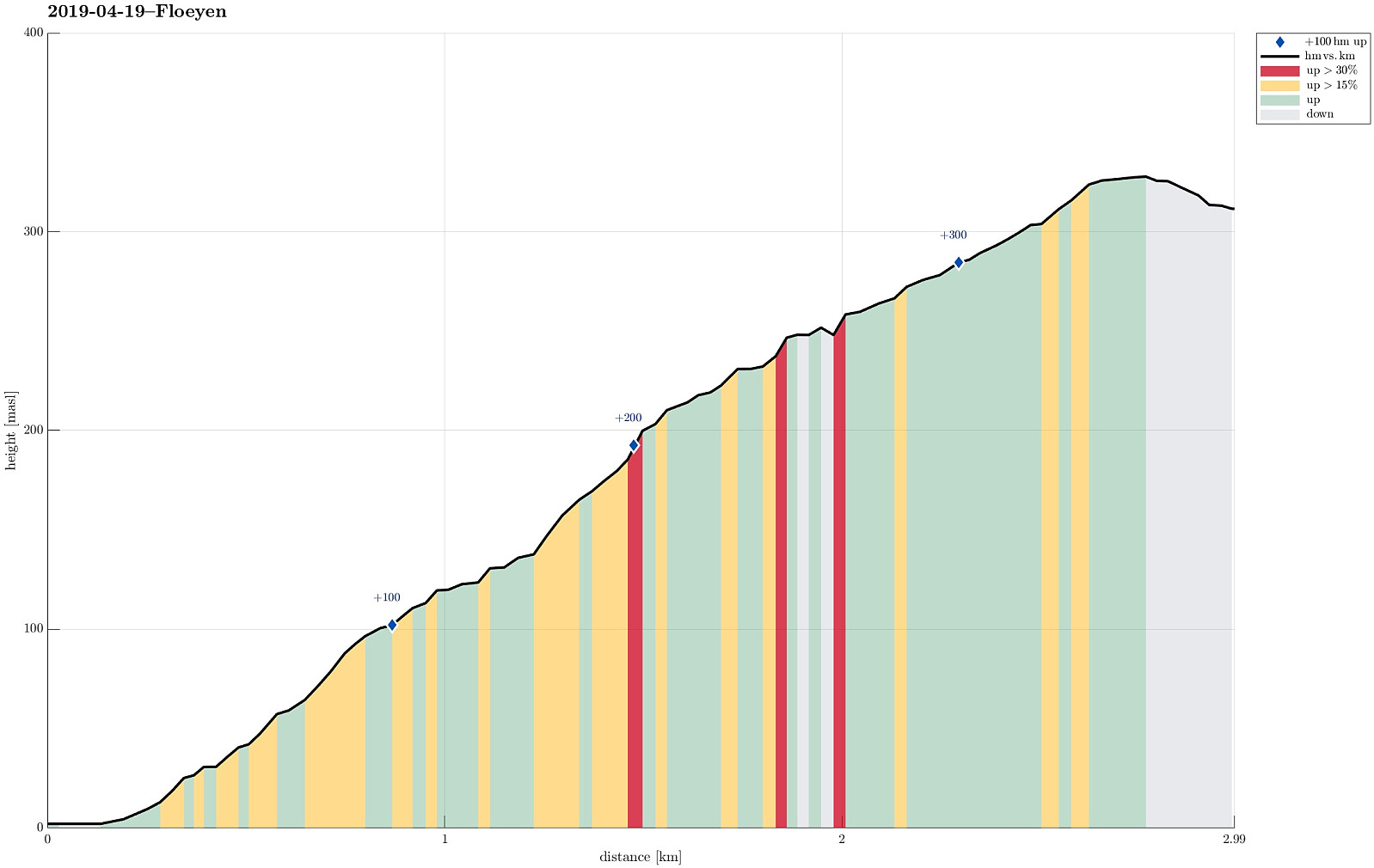 With guests, just arrived from Austria, we exploited the nice weather and showed Bergen from above (from Fløyen). Up by feet, down by Fløybanen. :-) Not a big hike (and definitely not alone), but clearly a nice day and always nice to look down onto Bergen from the top station of Fløybanen! :-)
See also the related FB-page Hiking around Bergen, Norway .
With guests, just arrived from Austria, we exploited the nice weather and showed Bergen from above (from Fløyen). Up by feet, down by Fløybanen. :-) Not a big hike (and definitely not alone), but clearly a nice day and always nice to look down onto Bergen from the top station of Fløybanen! :-)
See also the related FB-page Hiking around Bergen, Norway .
Knutstignova (return via Harafjellet)
- Dato:
- 14.04.2019
- Turtype:
- Fjelltur
- Turlengde:
- 6:00t
- Distanse:
- 12,2km
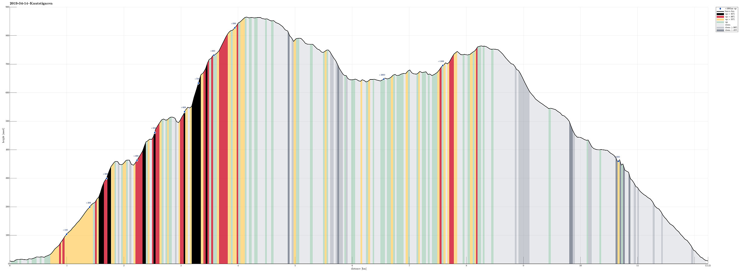 We took the E16 in the direction towards Voss from Bergen and left it (to the left / north) at Dalseid, right after Dale. We then followed the (very narrow!) road along Bolstadfjorden (Kastevika) towards the north until we came to the place where the lower ends of Dalseidmarkåna meet the road. There we parked, expecting that we would come back down here later, and started our hike first with a little more on the road (just around Tretteneset). We continued on the road over the bridge (water that comes down from Straumsmarkåna) and then turned left onto a nice forest road (it does not seem as if anything motorized used that road for a while though). This road/trail lead steeply up through the forest and into the direction of Botnastølen. At about 200mosl, we seemingly lost the trail, >>>
Husdalsfjellet via Husdalen from Kanalen
- Dato:
- 13.04.2019
- Turtype:
- Fjelltur
- Turlengde:
- 5:00t
- Distanse:
- 13,3km
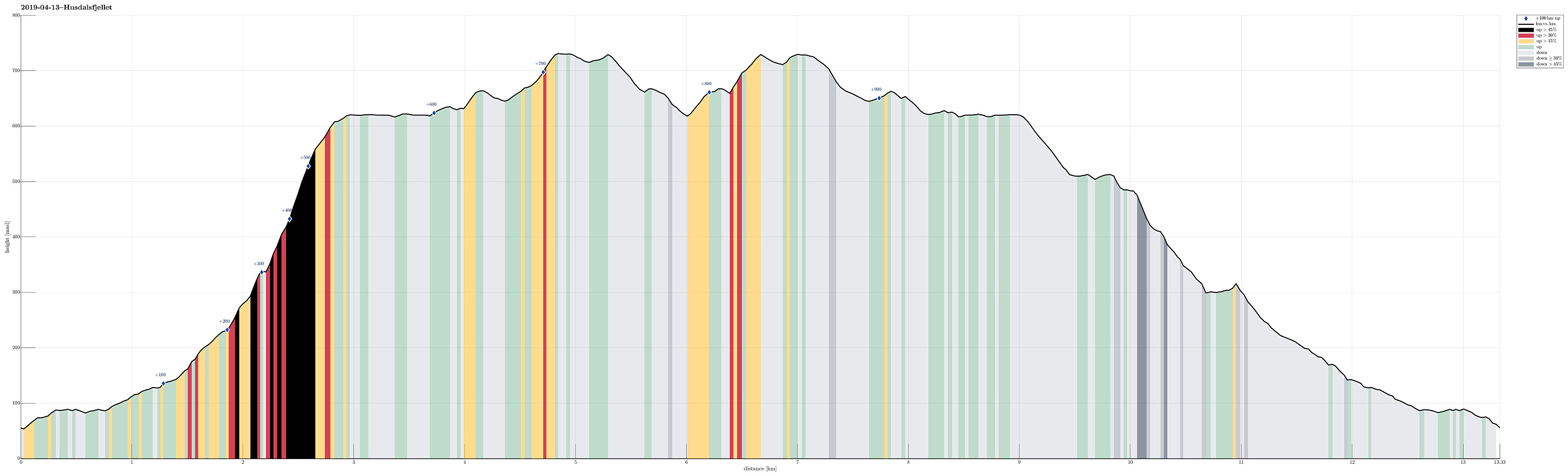 We took the E39 to the north of Bergen, crossing over to Knarvik over Nordhordlandsbrua. We then continued along E39 (in the direction of Førde) along the northern side of Osterfjorden. Right after Bjørsviktunnelen, we turned right at the second opportunity (marked towards Molvik there). Note that this exit comes almost immediately after the one to Bjørsviki, so it's good to keep your eyes open right after leaving the tunnel! :-) We then followed Molvikavegen for only a very short stretch until we crossed over the little bridge over Kanalen. Right after the bridge, we found a little place on the left, where we could park for a while. Just meters above the parking, a private road to Husdalen leaves to the northeast (left), locked behind a bar. We hiked along this road then, in the >>>
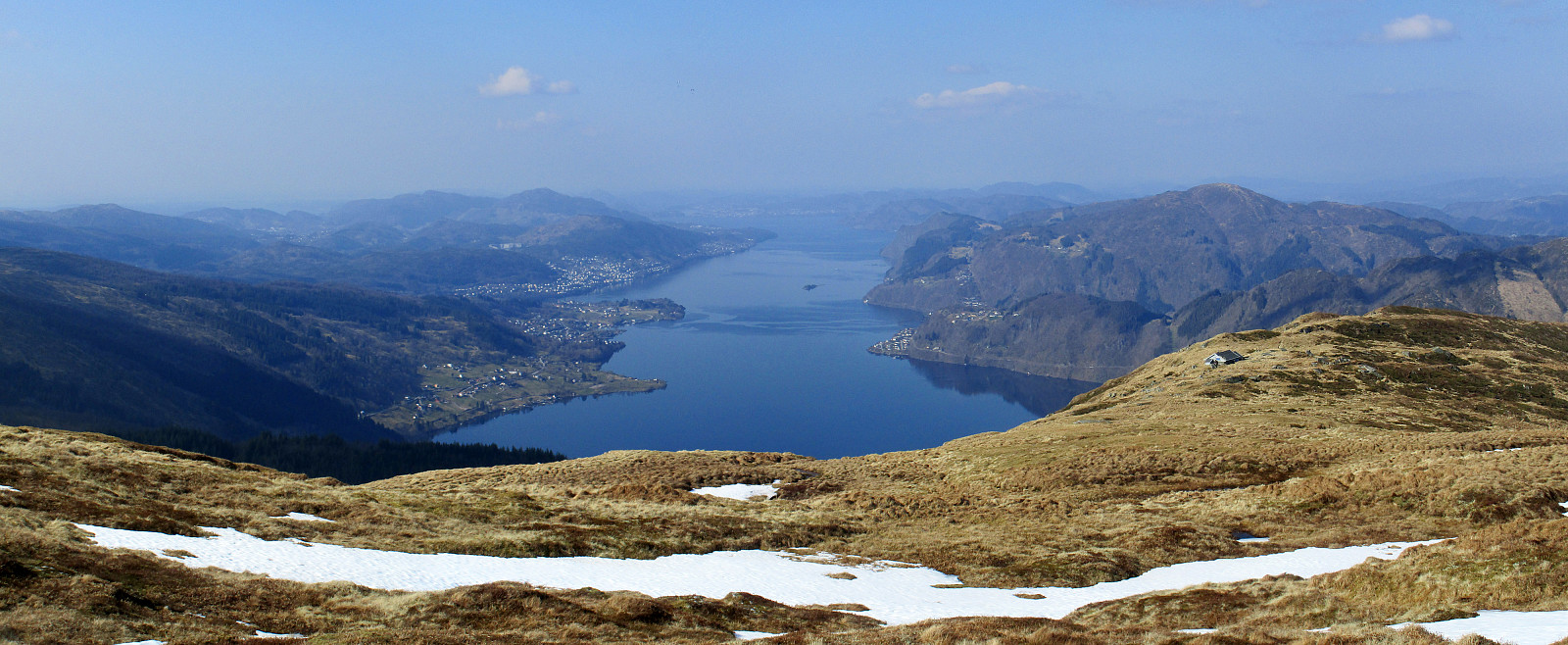
Short hike over Vardafjellet
- Dato:
- 12.04.2019
- Turtype:
- Spasertur
- Turlengde:
- 0:30t
- Distanse:
- 1,4km
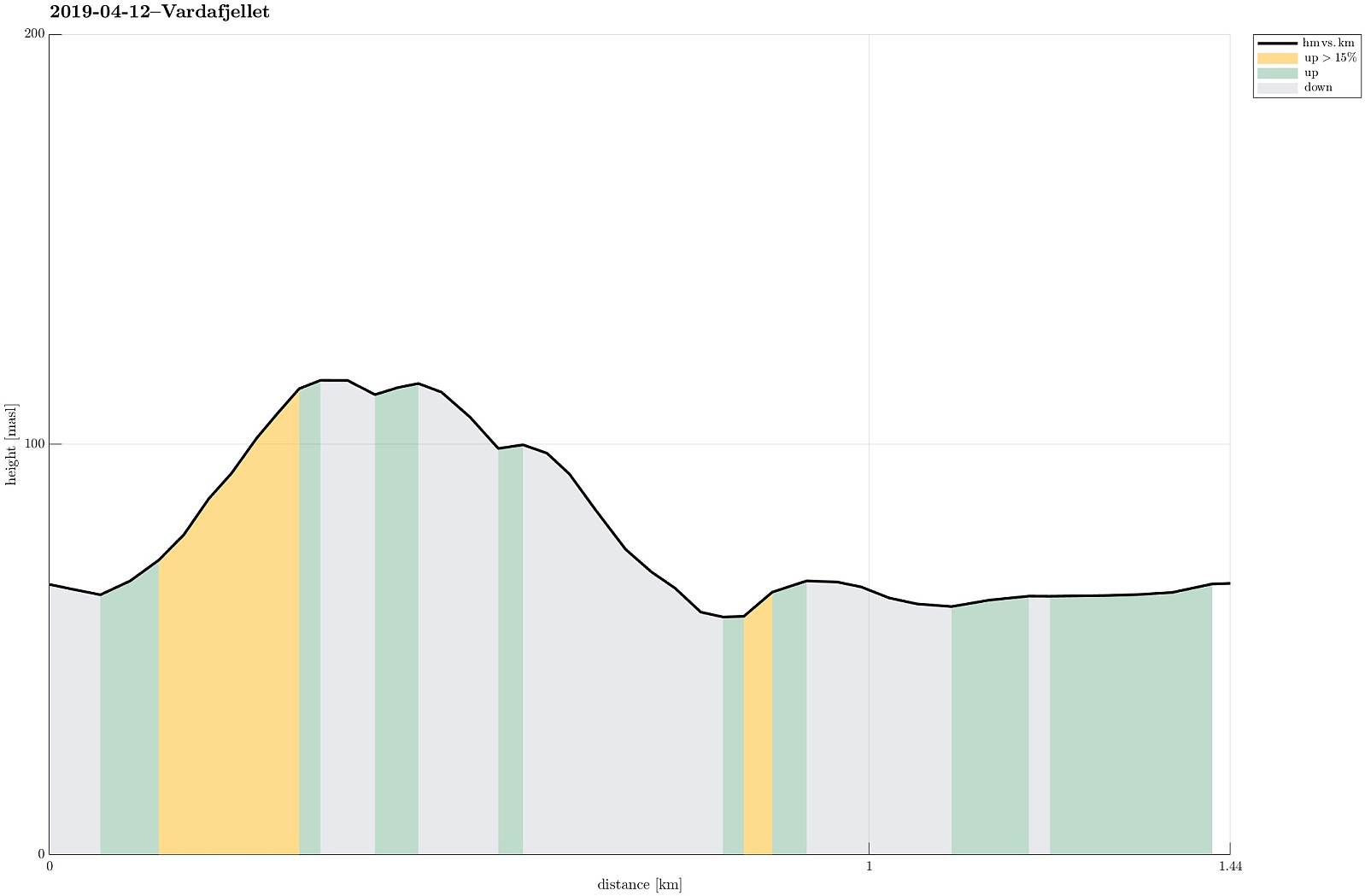 After a meeting at Solstrand, I was heading to another meeting in Bergen. Given the beautiful day and half an hour to spare, I decided to include a quick walk over one of the minor peaks near Osøyro: Vardafjellet. I drove up to Øvre Varåsen and found a place to park for half an hour. My plan was then to continue to Varåsgrenda and to take a trail from there (as I had seen it on the map). Walking north on Øvre Varåsen, however, I turned left one street too early. Soon, I understood that this would not lead to the trail, but since I thought that ascending to Vardafjellet should not be too difficult, even without a trail, I continued and indeed found a reasonable opportunity at the back of house 48 (southwest of it). Within a few minutes, I had connected to the trail and then followed >>>
Vossavardane via Innapåeggi and Utapåegga
- Dato:
- 07.04.2019
- Turtype:
- Fjelltur
- Turlengde:
- 3:45t
- Distanse:
- 9,1km
 We parked near Nedre Romslo at Romslovegen (very near to the E16). Our goal was to reach the ridge of Innapåeggi and then to follow it upwards into the direction of Gullfjellet. At house 243, shortly before crossing over E16, we left Romslovegen and started to ascend towards the ridge. First, we used a path until we came close to the forest. From there on, it was mostly through the forest and towards the ridge. This part was steep and the underground was partly unstable. It is highly recommended to plan carefully and to not follow this track without having good shoes. Also, it was useful to use our hands every now and then, before reaching the ridge. Clearly, this first part of our hike required a portion of hiking experience! Once on the ridge, however, the hike turned into a wonderful >>>
Livarden
- Dato:
- 06.04.2019
- Turtype:
- Fjelltur
- Turlengde:
- 3:30t
- Distanse:
- 9,3km
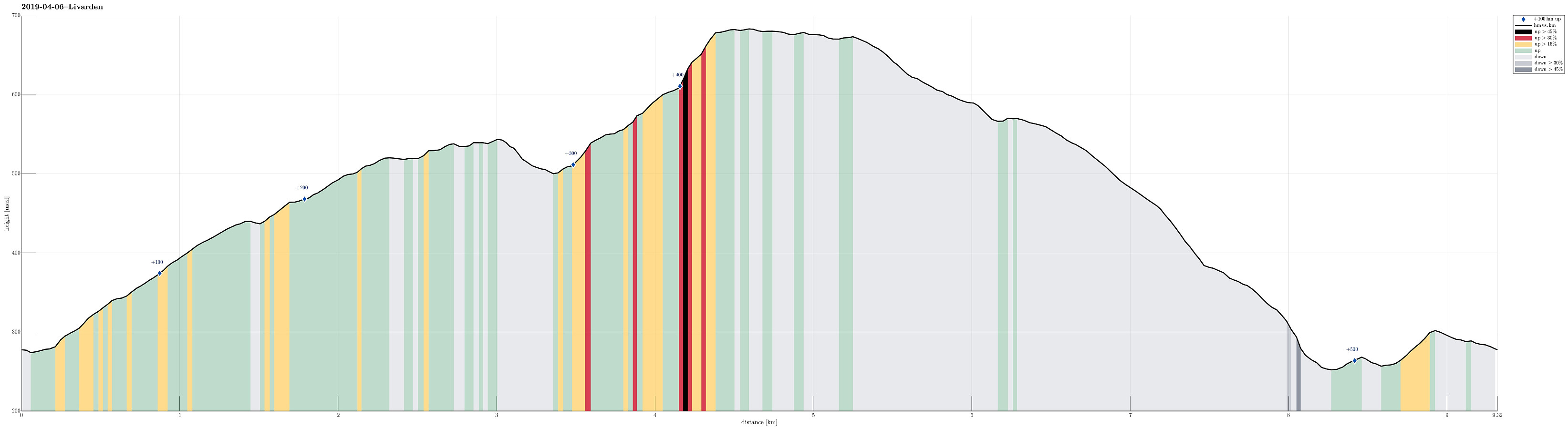 We started from the small parking place at Øvre Totland and headed right towards the long ridge of Totlandsfjellet. Enjoying lovely spring weather, we ascended swiftly towards the top of Totlandsfjellet. The next goal was then to cross over to Livarden. When getting over from Totlandsfjellet to Livarden near Seterhaugen, we were positively surprised that the terrain was not overly wet (even though we still saw a little bit of snow there). From Karvestølen it was then only a few minutes to ascent to Livarden via Nordvardsbrekkene. At Livarden, we enjoyed a short break, before heading back. Instead of hiking back the same path, however, we followed the ridge towards Ulvursfjellet (the main path up and down Livarden). Instead of staying on the higher ridge (with the main path), we followed >>>
