Arkiv - dato
Arkiv - aktivitet
-
Annen tur (1)
- Kajakkpadling (1)
-
Annen vintertur (4)
- Trugetur (4)
- Fottur (740)
-
Skitur (4)
- Fjellskitur (4)
-
Sykkeltur (137)
- Blandet sykling (51)
- Gatesykling (9)
Arkiv - Etter geografi
"Peakbookvenner"


Lister jeg samler etter
-
Bergen ≥ 50m pf. og ≥ 100 m.o.h.
(87/89)
 97%
97% -
Most dominating tops of the Bergen peninsula
(68/75)
90%
-
Utvalgte topper og turmål i Bergen
(316/352)
89%
-
Alle topper i Bergen
(357/400)
89%
-
Opptur Bergen
(100/113)
88%
-
De syv fjell rundt Bergen
(6/7)
85%
-
Sund ≥ 50m pf.
(14/18)
77%
-
Os ≥ 50m pf.
(25/34)
73%
-
Søyler (fastmerker) i Bergen
(68/100)
68%
-
Fjell ≥ 50m pf.
(21/32)
65%

Iseggene, Storefjellet, and Fårikken
- Dato:
- 24.02.2019
- Turtype:
- Fjelltur
- Turlengde:
- 4:00t
- Distanse:
- 14,6km
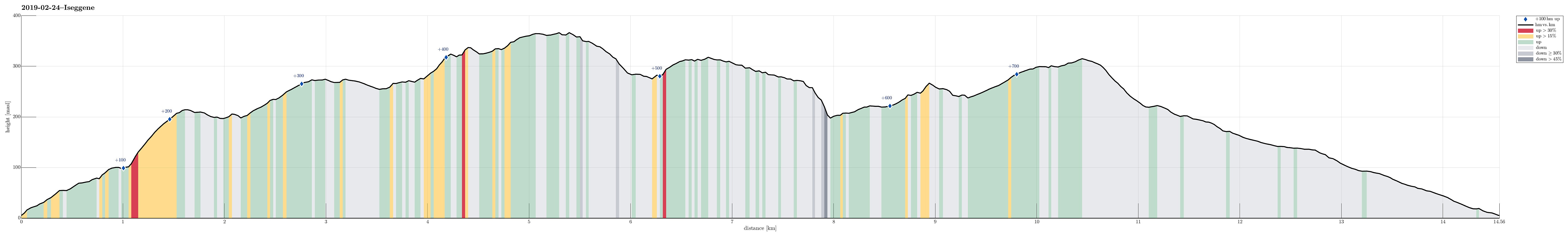 We took the car to Valestrand on Osterøy and parked near a playing ground not far from where the ferry arrives/leaves. In order to get up to Eidefjellet, we traversed a "labyrinth" of small roads up the northwestern side of Valestrand. Soon we arrived near the top-most house and found the trail head right next to it. From there, the continuation was nice and easy to find, following the ridge up in northwestern direction. After crossing Kjeringfjellet, we continued along the ridge (in northwestern direction). Before the trail swings to the right, in order to connect with Iseggene, we left the main path for a short excursion to Brattfjellet. Without finding any path there, we quickly ended up in quite a bit of vegetation, requiring a bit of explorer spirit to continue. After >>>
Around Tyssøy on a windy day
- Dato:
- 23.02.2019
- Turtype:
- Fottur
- Turlengde:
- 2:00t
- Distanse:
- 5,4km
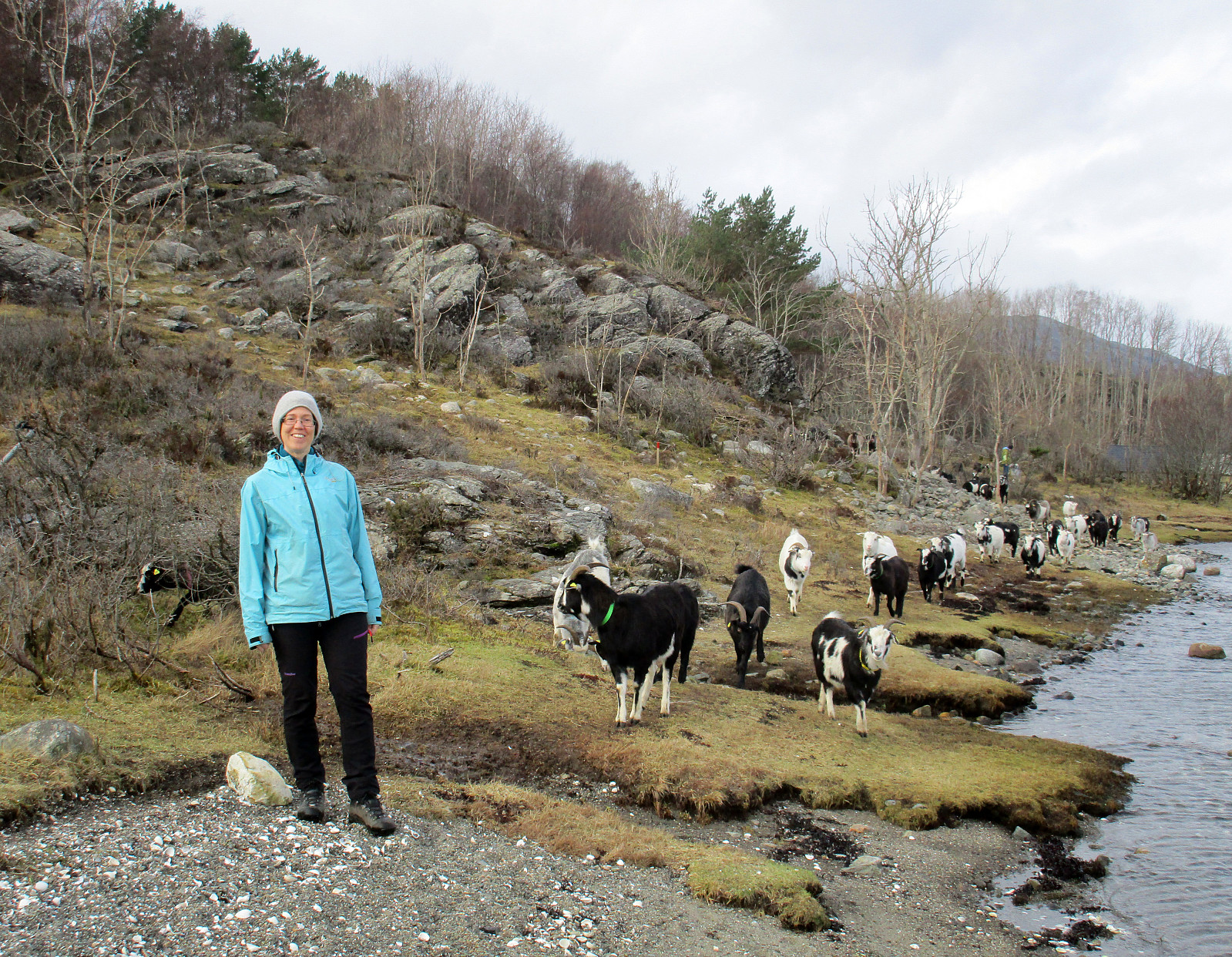 We took the car to Tyssøy (via Mathopen, then through the tunnel under Vatlestraumen, and then across Bjorøyna) and parked at Støene, where also the bus turns around. Our plan was to walk around the island and thus we left the "main road" already in the first turn (towards the southeast). We came by quite a number of goats before visiting Storeklubben first. From there, we first went a few steps back in order to reconnect with the main trail that leads southwards along the shore of Tyssøy (but a bit higher up in the terrain). We followed the well-marked path southwards until we came near to Slettevikklubben. There, instead of further following the trail, which leads "back" towards the central trail across the island, we improvised towards Børvika. This wasn't >>>
Sjurstonipa
- Dato:
- 17.02.2019
- Turtype:
- Fjelltur
- Turlengde:
- 2:00t
- Distanse:
- 6,1km
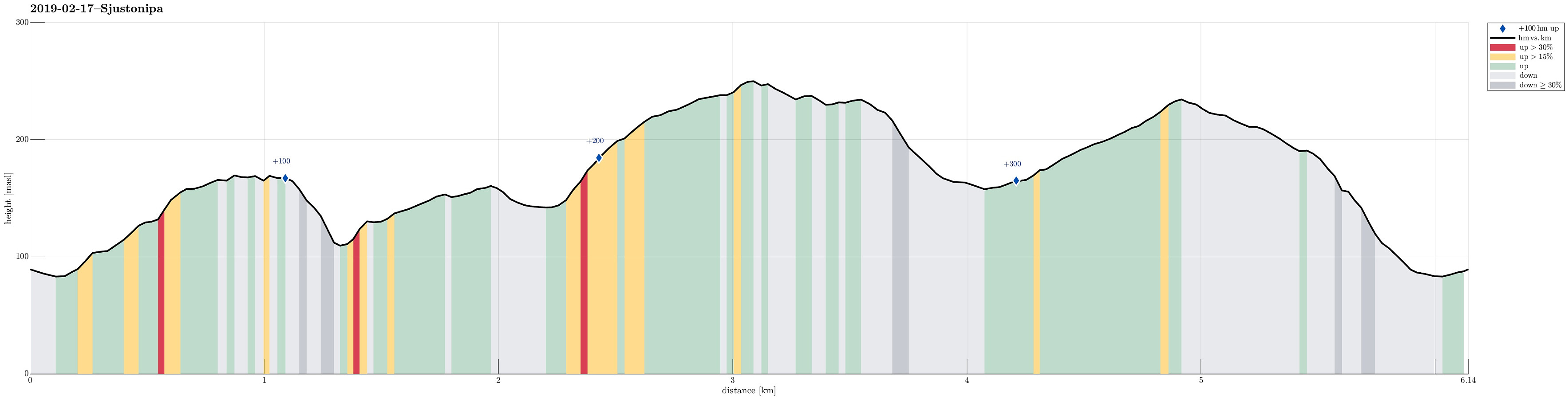 We took the car from Bergen via Åsane to Gaupås and parked right at Arna stadion. Our first goal was to visit Osen (via Gamsevegen) and to check whether one indeed has a nice view from up there -- and, yes, the view, for example across Gaupåsvatnet, is quite nice! :-) From there, we wanted to connect to Sjurstonipa. But instead of taking the nice path back, which we used to get up to Osen, we descended along a stone wall that runs towards the east from Osen. At the lower end of this descent (near Kvernaskaret), the terrain is quite a bit steep and choosing ones steps carefully was advised (no problem, though, to get down to the saddle). On the other side, we then ascended to the Lavvo place near the upper houses of Ytre Arna. Instead of entering Ytre Arna, we continued across the "top", >>>
Førdesveten from Stranda
- Dato:
- 03.02.2019
- Turtype:
- Fjelltur
- Turlengde:
- 2:45t
- Distanse:
- 7,1km
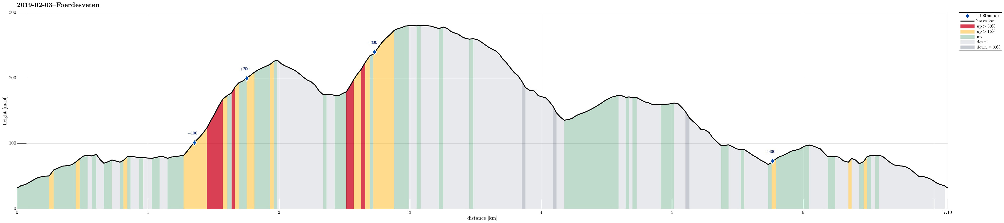 We took road 555 towards Sotra and then further south to Sund. At the Stranda school we parked, starting our hike from there. We first followed a well-visible path over Lamhusfjellet in order to get into Kleppadalen. Also there, the path was easy to follow and we continued along it into the direction of Førdesveten. From Kleppadalen, we then ascended in northeastern direction towards a saddle, where another path comes down from Ramnaberget in the southeast. Instead of immediately continuing towards Førdesveten, we decided to quickly ascend Storevarden (in the northwest of the saddle). There were no steps to see in the snow, but proceeding to the top was nonetheless quite OK. At Storevarden, one can appreciate an impressive stone wall that probably was built to confine sheep towards >>>
