Archivo - fecha
Archivo - actividad
-
Ciclismo (137)
- Ciclismo de carretera (9)
- Ciclismo mixto (51)
-
Excurción de esquí (4)
- Esquí de montaña (4)
-
Excurción de otro tipo (1)
- Kayak (1)
- Excursión de invierno, otro tipo (4)
-
Senderismo (740)
- Caminata (89)
- Running (18)
- Senderismo (270)
- Senderismo de montaña (363)
Archivo - por geografía
Amigos de Peakbook


Listas obtenidas
-
Bergen ≥ 50m pf. og ≥ 100 m.o.h.
(87/89)
 97%
97% -
Most dominating tops of the Bergen peninsula
(68/75)
90%
-
Utvalgte topper og turmål i Bergen
(316/352)
89%
-
Alle topper i Bergen
(357/400)
89%
-
Opptur Bergen
(100/113)
88%
-
De syv fjell rundt Bergen
(6/7)
85%
-
Sund ≥ 50m pf.
(14/18)
77%
-
Os ≥ 50m pf.
(25/34)
73%
-
Søyler (fastmerker) i Bergen
(68/100)
68%
-
Fjell ≥ 50m pf.
(21/32)
65%

Vasslifjellet via Soleibakkane
- Fecha:
- 25.11.2018
- Tipo de excursión:
- Senderismo de montaña
- Duración:
- 3:00h
- Distancia:
- 10.8km
 We took the car to Sædalen, behind Nattlandsfjellet, and parked it at the lower end of Indre Sædal. From there, we first followed street Sædalssvingane upwards (in northeastern direction, towards Løypingsberget). But instead of following the road all the way to its highest point, we on the eastern side of the valley and ascended (mostly without a path there) further up there. Shortly before reconnecting with the road (at its highest point), we aligned with the water that is coming down from Søre Gløvrevatnet. We climbed further up, first on the water's eastern side, before then crossing it and ascending to the ridge that leads further up from there. There, we also found a nice path, which was easy and straight-forward to follow further upwards. Soon after, we came to Søre Gløvrevatnet >>>
Knappen
- Fecha:
- 24.11.2018
- Tipo de excursión:
- Senderismo de montaña
- Duración:
- 1:00h
- Distancia:
- 5.7km
 To get a little bit of fresh air, we made a quick hike over Knappen. Instead of returning via Knappetjørna and Vassteigen, we descended via Hesthaugen and returned along Sælenvatnet back to Varden.
See also the related FB-page Hiking around Bergen, Norway .
Petter Bjørstad has a useful page about Knappen .
To get a little bit of fresh air, we made a quick hike over Knappen. Instead of returning via Knappetjørna and Vassteigen, we descended via Hesthaugen and returned along Sælenvatnet back to Varden.
See also the related FB-page Hiking around Bergen, Norway .
Petter Bjørstad has a useful page about Knappen .
Bogafjellet from Reinsvegen
- Fecha:
- 18.11.2018
- Tipo de excursión:
- Senderismo de montaña
- Duración:
- 3:45h
- Distancia:
- 11.3km
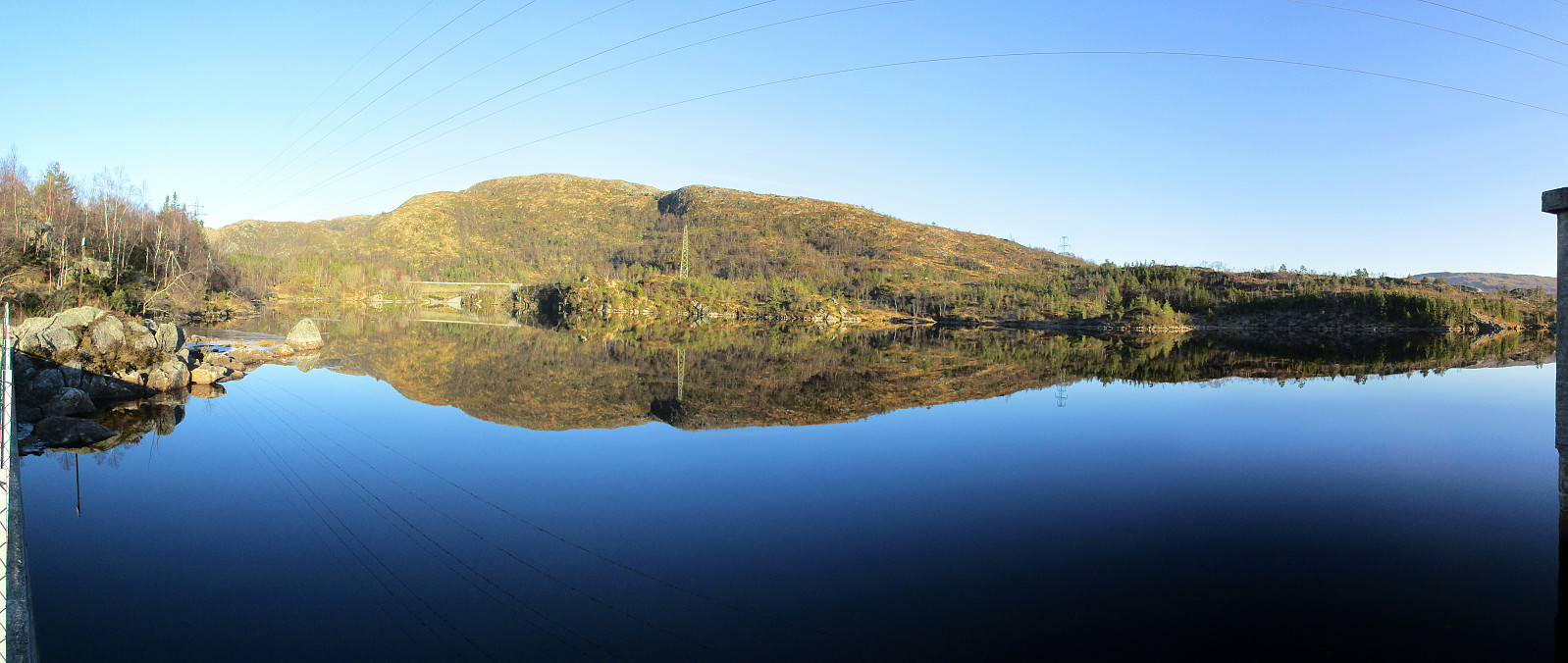
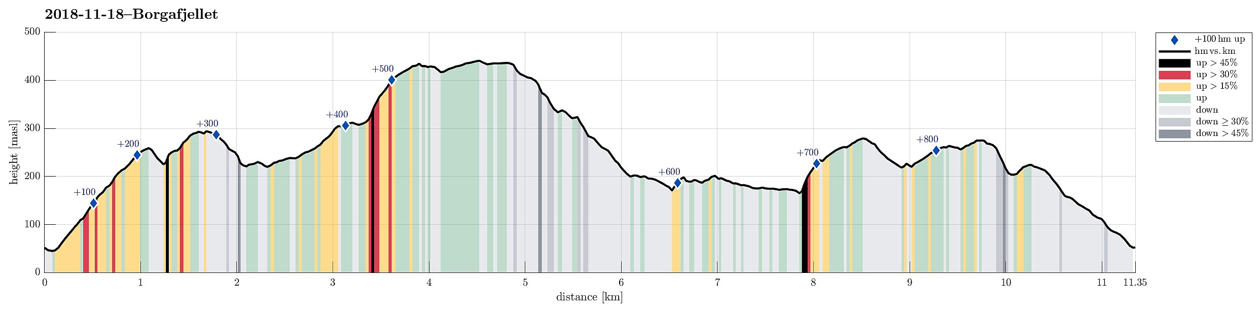 Even though the weather, with very low hanging clouds, did not look all to promising for a hike somewhere higher up, I still decided to give it a try and headed south and towards Fusa (via Osøyro, then taking the ferry from Hatvik to Senjaneset). Even on the ferry across Fusafjorden I wondered, whether it was that good an idea at all (the impression which the sun made, breaking through the low-hanging clouds, however, was definitely worth the view!). After arriving in Fusa, I quickly turned right from the main road and followed road 122 towards Strandvik (via Vinnes). Before actually getting to the "center" of Strandvik, I turned left and headed towards Reinsvegen. Passing by Kvåle, I drove up the valley until a spot near Snøhaugen. From there, I had planned to hike a round >>>
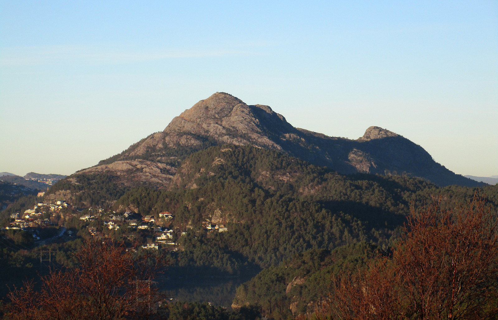
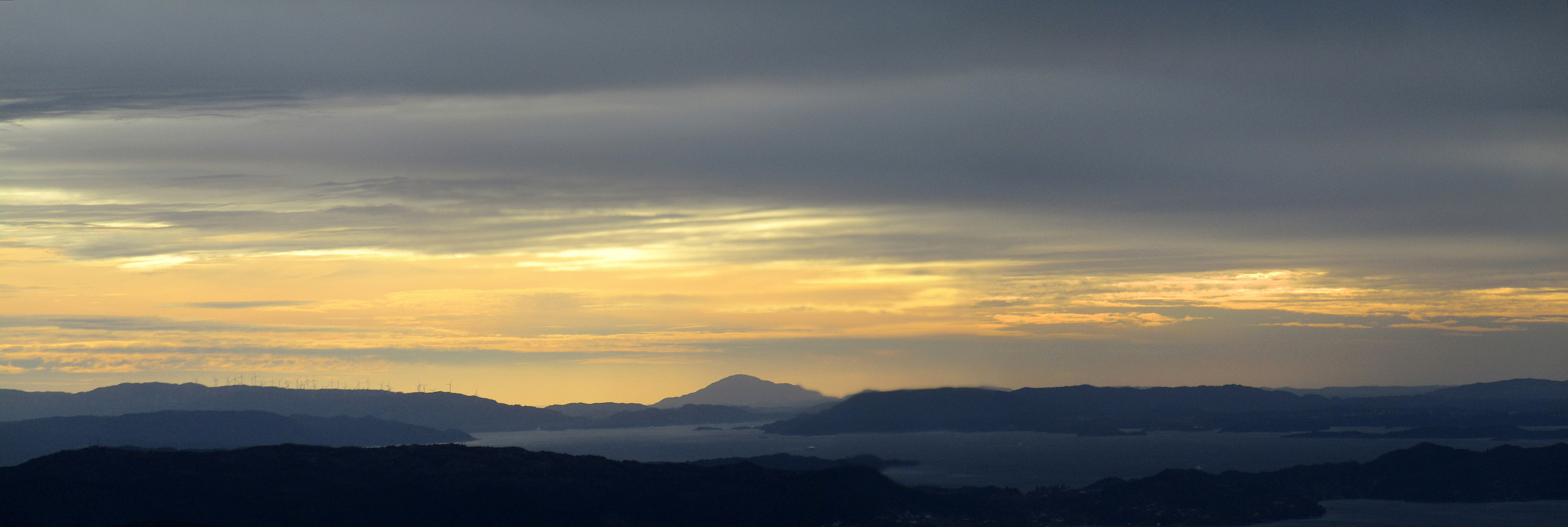
Stendafjellet at about sunset
- Fecha:
- 17.11.2018
- Tipo de excursión:
- Senderismo de montaña
- Duración:
- 1:00h
- Distancia:
- 3.4km
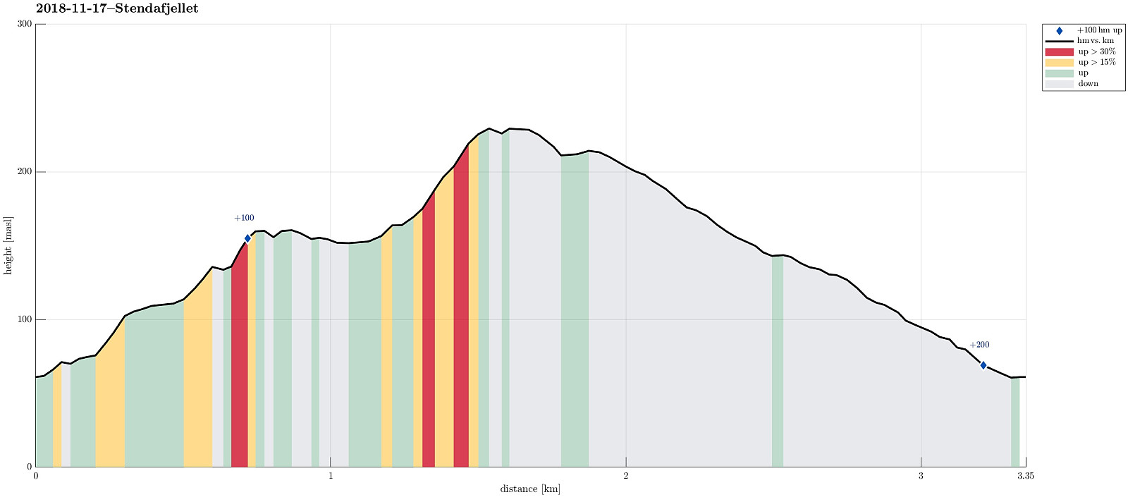 Even though it was already a bit late (for November in Bergen), there still was a chance for a short hike. From the little parking place near the previous train station at Stend (a bit north of Fana), I headed directly into the forest (in northern direction), not following the gravel road that also starts from there (a bit further east). After only a few steps, I got to a little pond (seemingly hold back by a little dam) and chose to surround it on its western side. In order to get further up, I crossed a little saddle north of the pond and ascended through the forest in northeastern direction, following one of apparently several possible routes. Once a bit further up, the terrain flattened out (a bit) and I continued in northern direction, heading towards Stendaåsen. After reaching the >>>
Løvstakken for some fresh air
- Fecha:
- 04.11.2018
- Tipo de excursión:
- Senderismo de montaña
- Duración:
- 1:00h
- Distancia:
- 3.1km
 Due to a lack of more time, we this time "only" made a quick hike up Løvstakken. We parked right next to Litlavatnet in Fyllingsdalen and ascended via the main path to Løvstakken from there (first towards Ravnefjellet, then around and up to Løvstakken). After a short stop at the top (in strong winds!), we returned along the same path. Always good to at least get a bit of fresh air! :-)
Selected photos are available as Google photo album .
See also the related FB-page Hiking around Bergen, Norway .
Web page WestCoastPeaks.com provides useful information about Løvstakken .
Due to a lack of more time, we this time "only" made a quick hike up Løvstakken. We parked right next to Litlavatnet in Fyllingsdalen and ascended via the main path to Løvstakken from there (first towards Ravnefjellet, then around and up to Løvstakken). After a short stop at the top (in strong winds!), we returned along the same path. Always good to at least get a bit of fresh air! :-)
Selected photos are available as Google photo album .
See also the related FB-page Hiking around Bergen, Norway .
Web page WestCoastPeaks.com provides useful information about Løvstakken .
