Archive - Date
Archive - Activity
-
Bike trip (137)
- Bike trip - mixed (51)
- Bike trip - road (9)
-
Other trip (1)
- Kayaking (1)
-
Other winter trip (4)
- Snowshoe trip (4)
- Ski trip (4)
- Trip by foot (740)
Archive - Geography
Peakbook-Friends


Collected lists
-
Bergen ≥ 50m pf. og ≥ 100 m.o.h.
(87/89)
 97%
97% -
Most dominating tops of the Bergen peninsula
(68/75)
90%
-
Utvalgte topper og turmål i Bergen
(316/352)
89%
-
Alle topper i Bergen
(357/400)
89%
-
Opptur Bergen
(100/113)
88%
-
De syv fjell rundt Bergen
(6/7)
85%
-
Sund ≥ 50m pf.
(14/18)
77%
-
Os ≥ 50m pf.
(25/34)
73%
-
Søyler (fastmerker) i Bergen
(68/100)
68%
-
Fjell ≥ 50m pf.
(21/32)
65%

Vemånen, Hovden, etc.
- Date:
- 30.09.2018
- Characteristic:
- Hillwalk
- Duration:
- 2:30h
- Distance:
- 7.4km
 On this day with a "mixed" weather prediction, we decided to do a smaller hike, still trying something new. We parked near the Unneland Kultur og Aktivitetshus at Unnelandsvegen 253, 5268 Haukeland, and walked from there.
Immediately after crossing the bridge over the stream that comes down from Seterdalen (as well as from Rambjørgsgjelet), heading towards Haukelandsvatnet (at Nesvika), we found the path to Vemånen (first passing by Rodalshaugen). This is a very easy to find and nice to walk path, following the ridge (mostly in northern direction) up to Vemånen. Near the top of Vemånen, one gets out of the forest and can enjoy some nice views, in particular over Haukeland and Haukelandsvatnet. The best viewpoint, however, is not at the "top" of Vemånen, but a few >>>
On this day with a "mixed" weather prediction, we decided to do a smaller hike, still trying something new. We parked near the Unneland Kultur og Aktivitetshus at Unnelandsvegen 253, 5268 Haukeland, and walked from there.
Immediately after crossing the bridge over the stream that comes down from Seterdalen (as well as from Rambjørgsgjelet), heading towards Haukelandsvatnet (at Nesvika), we found the path to Vemånen (first passing by Rodalshaugen). This is a very easy to find and nice to walk path, following the ridge (mostly in northern direction) up to Vemånen. Near the top of Vemånen, one gets out of the forest and can enjoy some nice views, in particular over Haukeland and Haukelandsvatnet. The best viewpoint, however, is not at the "top" of Vemånen, but a few >>>
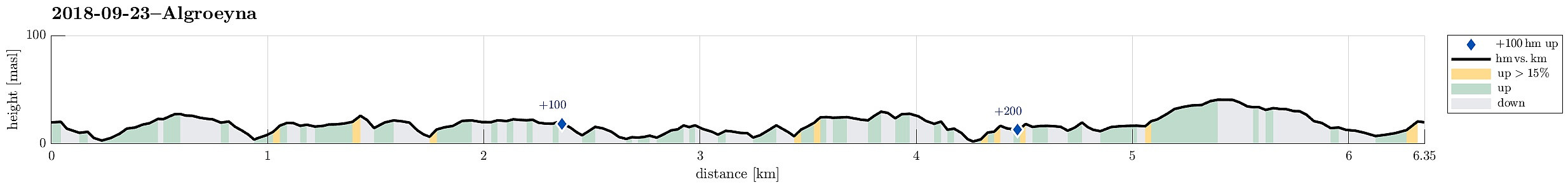
Algrøyna, Barmaneset, Langtrotten -- wow!
- Date:
- 23.09.2018
- Characteristic:
- Hike
- Duration:
- 3:30h
- Distance:
- 6.4km
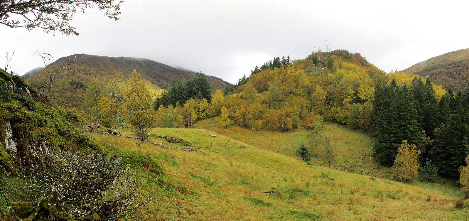
 We parked the cars just before entering the main village on Algrøyna and started to hike from there. It had just poored down substantially, but as we started hiking the weather improved and soon we saw some sun, also! :-) We first followed the "main road", Nordre Øyavegen, in a longer swing to the right/north, before turning left, continuing on Kongvikvegen. Before the end of this road and about where Kungvika has its western-most point, we left the road, walking around a farm house right next to the road, in order to connect to the southern side of Kungvika (and eventually to Barmaneset). Once on the "middle" peninsula of Algrøyna, we followed a path with blue marks towards the west. This path leads out on Barmaneset and to Krabbakeila at its western end. Enjoying >>>
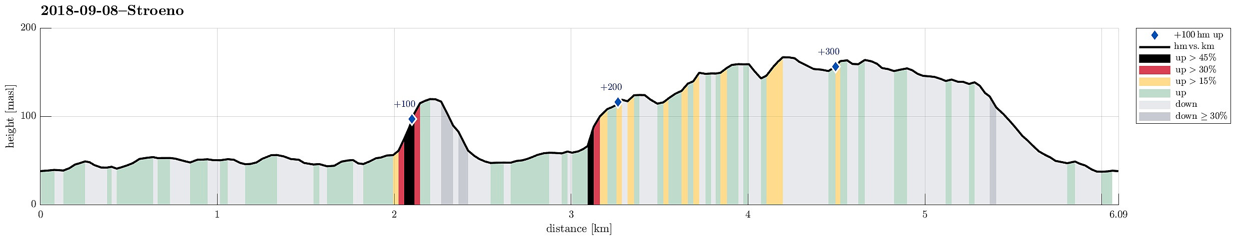
Hiking the southern part of Strøno
- Date:
- 08.09.2018
- Characteristic:
- Hike
- Duration:
- 2:30h
- Distance:
- 6.1km
 There was not really time for a longer hike and also it was expected that some rather heavy rain may come in the early evening. Therefore, we decided to do something smaller, i.e., a hike over Strøno south of Bergen (and west of Osøyro). We passed Fanafjellet with our car and turned right (westwards) at the military camp at Ulven. Following the street, we soon crossed over the bridge at Hillershavn to Strøno. Once on Strøno, we followed the southern street to Sørstrøno. From there, we started hiking, first following a major gravel road which passes by Strønevågen and Selvågspollen (in their northwest).
Our first goal was Husfjellet, a little hill that stands a bit for its own in the very south of Strøno. We first continued on the gravel road, making a half-circle around the hill >>>
There was not really time for a longer hike and also it was expected that some rather heavy rain may come in the early evening. Therefore, we decided to do something smaller, i.e., a hike over Strøno south of Bergen (and west of Osøyro). We passed Fanafjellet with our car and turned right (westwards) at the military camp at Ulven. Following the street, we soon crossed over the bridge at Hillershavn to Strøno. Once on Strøno, we followed the southern street to Sørstrøno. From there, we started hiking, first following a major gravel road which passes by Strønevågen and Selvågspollen (in their northwest).
Our first goal was Husfjellet, a little hill that stands a bit for its own in the very south of Strøno. We first continued on the gravel road, making a half-circle around the hill >>>
Via Purkedalsgjelet to Kofta etc.
- Date:
- 02.09.2018
- Characteristic:
- Hillwalk
- Duration:
- 7:45h
- Distance:
- 18.2km
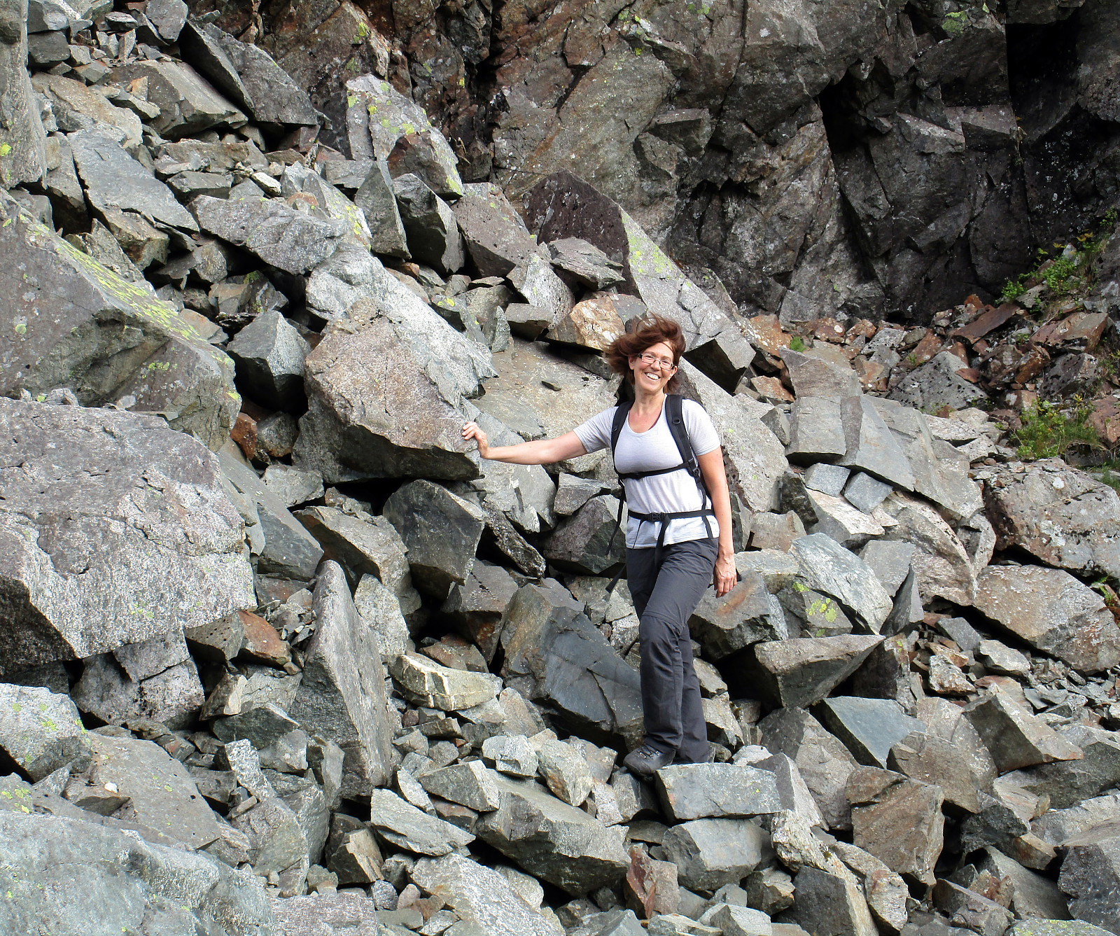 This hike, and in particular the part through Purkedalsgjelet up to Kofta, was one that asked for a careful preparation. It's recommended that you study the circumstances carefully and choose also the weather conditions appropriately. In order to enjoy this hike, you should (a) be at least somewhat experienced with hiking in the mountains around Bergen, in particular also without a path (finding your way, etc.) and (b) choose a dry day on which you can expect that there would not be too much water coming down Purkedalsgjelet (I'd rather not go this hike when snow is melting on Gullfjellet, or after some heavy rain). Take care (and enjoy)! :-)
We parked along the road from Os to Samnanger (#137), which passes Gullfjellet on its eastern (generally very steep) side. Actually, we first missed >>>
This hike, and in particular the part through Purkedalsgjelet up to Kofta, was one that asked for a careful preparation. It's recommended that you study the circumstances carefully and choose also the weather conditions appropriately. In order to enjoy this hike, you should (a) be at least somewhat experienced with hiking in the mountains around Bergen, in particular also without a path (finding your way, etc.) and (b) choose a dry day on which you can expect that there would not be too much water coming down Purkedalsgjelet (I'd rather not go this hike when snow is melting on Gullfjellet, or after some heavy rain). Take care (and enjoy)! :-)
We parked along the road from Os to Samnanger (#137), which passes Gullfjellet on its eastern (generally very steep) side. Actually, we first missed >>>
