Arkiv - dato
Arkiv - aktivitet
-
Annen tur (1)
- Kajakkpadling (1)
-
Annen vintertur (4)
- Trugetur (4)
- Fottur (740)
-
Skitur (4)
- Fjellskitur (4)
-
Sykkeltur (137)
- Blandet sykling (51)
- Gatesykling (9)
Arkiv - Etter geografi
"Peakbookvenner"


Lister jeg samler etter
-
Bergen ≥ 50m pf. og ≥ 100 m.o.h.
(87/89)
 97%
97% -
Most dominating tops of the Bergen peninsula
(68/75)
90%
-
Utvalgte topper og turmål i Bergen
(316/350)
90%
-
Alle topper i Bergen
(357/398)
89%
-
Opptur Bergen
(100/113)
88%
-
De syv fjell rundt Bergen
(6/7)
85%
-
Sund ≥ 50m pf.
(14/18)
77%
-
Os ≥ 50m pf.
(25/34)
73%
-
Søyler (fastmerker) i Bergen
(68/100)
68%
-
Fjell ≥ 50m pf.
(21/32)
65%

Rotterdam-exploration 01: close to the center
- Dato:
- 18.07.2017
- Turtype:
- Sykkeltur
- Turlengde:
- 2:00t
- Distanse:
- 20,2km
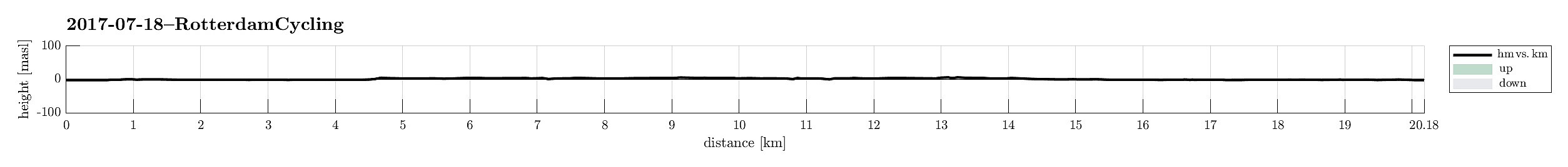 This first exploration of Rotterdam on our bikes brought us first and foremost to its center and then a little around. Rotterdam is really nice to explore on a bike with bike paths in all directions.
Selected photos are available as Google photo album .
See also the FB-page Hiking around Bergen, Norway .
This first exploration of Rotterdam on our bikes brought us first and foremost to its center and then a little around. Rotterdam is really nice to explore on a bike with bike paths in all directions.
Selected photos are available as Google photo album .
See also the FB-page Hiking around Bergen, Norway .
Geitanipa
- Dato:
- 08.07.2017
- Turtype:
- Fjelltur
- Turlengde:
- 2:00t
- Distanse:
- 4,8km
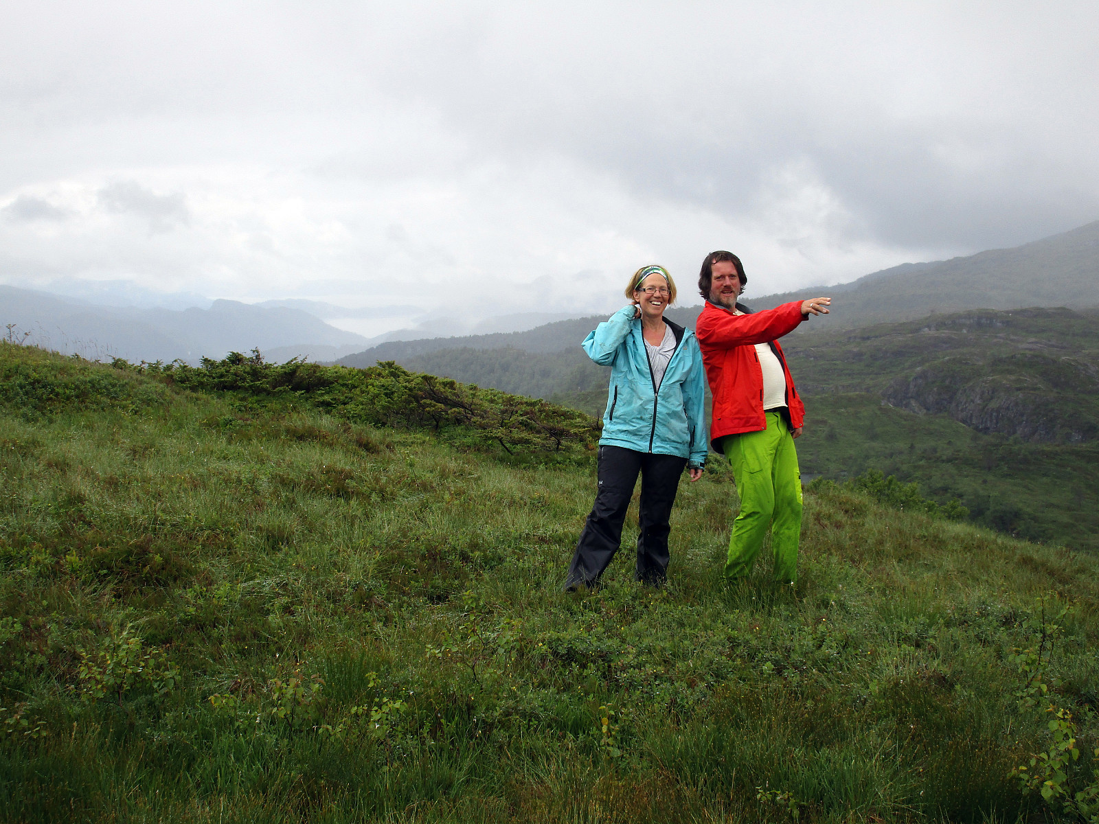 We started from Langhelle, between Trengereid and Vaksdal, at the end of the paved (small and narrow) road, which winds up there from E16 near the fjord. We first walked up a little longer along the gravel road until the point, where it makes a sharp turn right, leading further up to Seterkokane. We then followed a forest trail that brought us further up (in southeastern direction) to the saddle between Trollaberget and Geitanipa. At about this saddle, we decided to not descend to the southern side, but instead to connect to Geitanipa, instead. While there was not really any path or trail to Geitanipa, we still managed to get there without major difficulties (Geitanipa is, in fact, a bit steep on its eastern side, so it is necessary to carefully choose a good spot for ascending to it). >>>
Summer evening on Lyderhorn
- Dato:
- 03.07.2017
- Turtype:
- Fjelltur
- Turlengde:
- 2:00t
- Distanse:
- 4,6km
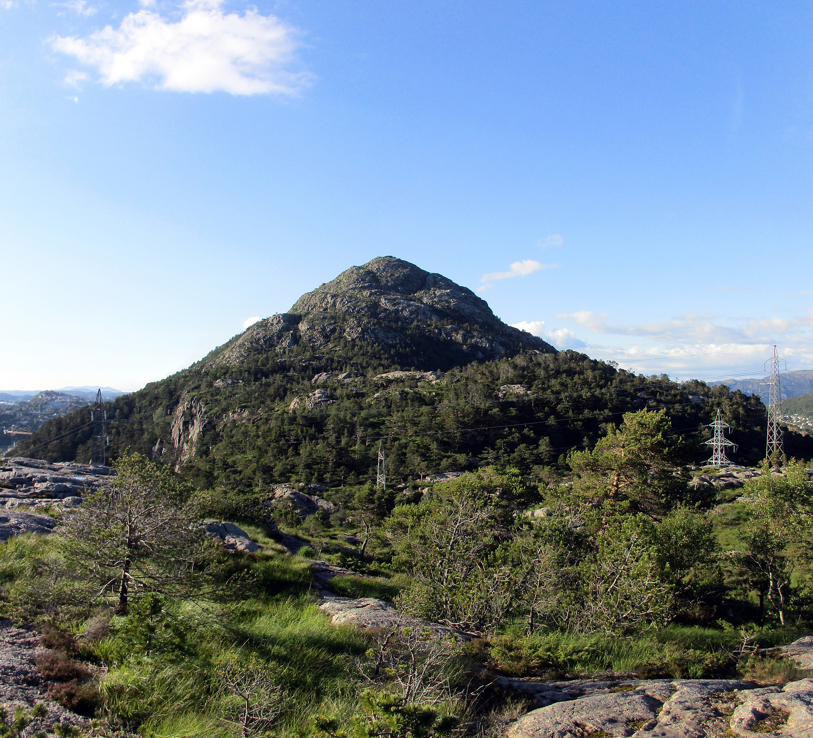 We took the car along road 557 towards Bjørndalen, where we parked right next to Bjørndalstjørna. We crossed the double-lane street (Lyderhornsveien) and found a narrow passage that led us up to Bjørndalsbakken. From there, we connected to Sildaberget and between houses 31 and 35 we found the narrow opening, which leads the path that brings one up the steep mountain-side there.
Before actually ascending to Lyderhorn, we first crossed Skarpafjellet in the south of Lyderhorn. Once up the little top, there, one can enjoy some very nice views in all directions.
In order to get further to Lyderhorn, we descended from Skarpafjellet on its northeastern side, avoiding the very steep side towards Grøvledalen. From the saddle, where also a power line is crossing, we then followed a path, which >>>
We took the car along road 557 towards Bjørndalen, where we parked right next to Bjørndalstjørna. We crossed the double-lane street (Lyderhornsveien) and found a narrow passage that led us up to Bjørndalsbakken. From there, we connected to Sildaberget and between houses 31 and 35 we found the narrow opening, which leads the path that brings one up the steep mountain-side there.
Before actually ascending to Lyderhorn, we first crossed Skarpafjellet in the south of Lyderhorn. Once up the little top, there, one can enjoy some very nice views in all directions.
In order to get further to Lyderhorn, we descended from Skarpafjellet on its northeastern side, avoiding the very steep side towards Grøvledalen. From the saddle, where also a power line is crossing, we then followed a path, which >>>
