Arkiv - dato
Arkiv - aktivitet
-
Annen tur (1)
- Kajakkpadling (1)
-
Annen vintertur (4)
- Trugetur (4)
- Fottur (740)
-
Skitur (4)
- Fjellskitur (4)
-
Sykkeltur (137)
- Blandet sykling (51)
- Gatesykling (9)
Arkiv - Etter geografi
"Peakbookvenner"


Lister jeg samler etter
-
Bergen ≥ 50m pf. og ≥ 100 m.o.h.
(87/89)
 97%
97% -
Most dominating tops of the Bergen peninsula
(68/75)
90%
-
Utvalgte topper og turmål i Bergen
(316/352)
89%
-
Alle topper i Bergen
(357/400)
89%
-
Opptur Bergen
(100/113)
88%
-
De syv fjell rundt Bergen
(6/7)
85%
-
Sund ≥ 50m pf.
(14/18)
77%
-
Os ≥ 50m pf.
(25/34)
73%
-
Søyler (fastmerker) i Bergen
(68/100)
68%
-
Fjell ≥ 50m pf.
(21/32)
65%

Meeting the North Atlantic at Skogsøya
- Dato:
- 24.06.2017
- Turtype:
- Fjelltur
- Turlengde:
- 2:00t
- Distanse:
- 5,3km
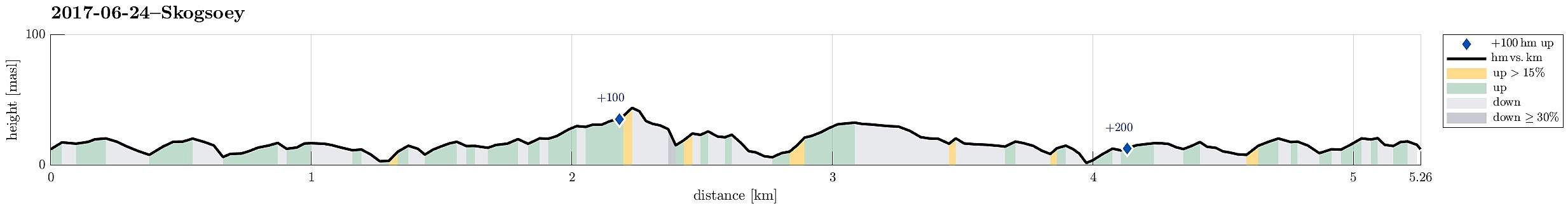 We took the car from Bergen to the west and then further north to Øygarden. On Ona, right next to Kollsnes, we left road 561 and continued on road 228 towards Herdleværet. On Skogsøyna, just before crossing the bridge to Herdleværet, we parked the car and started to hike towards the west, following the northern rim of Skogsøyna. First, we were positively impressed about work that seemingly was done quite recently to further improve this trail, making it easier to avoid wet and/or muddy shoes (at least to a certain degree). Nice! :-)
At the outer tip of Skogsøyna, we reached our goal for this day, Skoysøytua (some 50m above sea level and with nice views over the open Atlantic!). We explored the cliffs and watched the energetic ocean rumble against the rocks of Skogsøytua. We also >>>
We took the car from Bergen to the west and then further north to Øygarden. On Ona, right next to Kollsnes, we left road 561 and continued on road 228 towards Herdleværet. On Skogsøyna, just before crossing the bridge to Herdleværet, we parked the car and started to hike towards the west, following the northern rim of Skogsøyna. First, we were positively impressed about work that seemingly was done quite recently to further improve this trail, making it easier to avoid wet and/or muddy shoes (at least to a certain degree). Nice! :-)
At the outer tip of Skogsøyna, we reached our goal for this day, Skoysøytua (some 50m above sea level and with nice views over the open Atlantic!). We explored the cliffs and watched the energetic ocean rumble against the rocks of Skogsøytua. We also >>>
Cala del Cau from Far de San Sebastia
- Dato:
- 17.06.2017
- Turtype:
- Fjelltur
- Turlengde:
- 2:00t
- Distanse:
- 2,2km
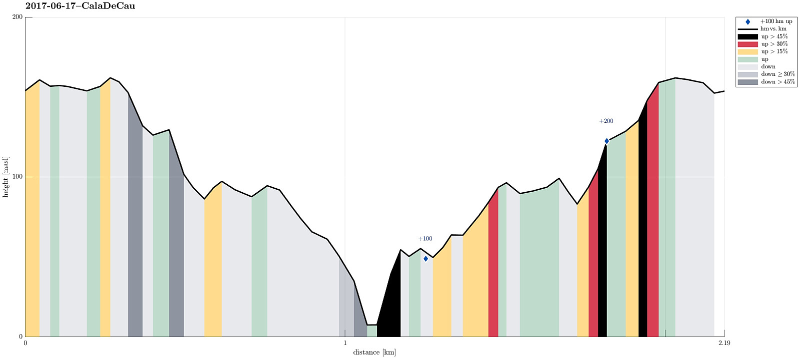 I started my trip in Barcelona with the goal to see a little of the wild and nice Costa Brava. After some driving, I started to head for Far de San Sebastia, mostly because I expected some nice views from there. The car brought me all the way up to this little hill and I parked right next to the restaurant Far de San Sebastia. I then explored the hill-top with Torre de Guaita de San Sebastia, overlooking the Mediterranean sea and also large parts of the nearby land. I found a little path at the steep eastern side facing the sea and followed it in northern direction. After a little up and down along the steep mountain side, I got the idea that I could try to get down to the sea (and explore also the waters there!). Following some small tracks through the forest, I found a path that headed >>>
Løvstakken and Strandafjellet
- Dato:
- 05.06.2017
- Turtype:
- Fjelltur
- Turlengde:
- 2:00t
- Distanse:
- 5,5km
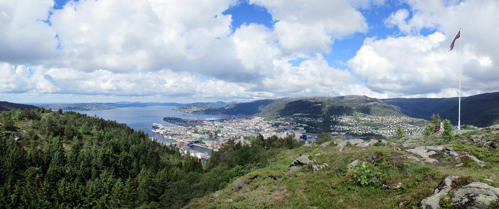 We parked right above Litlavatet up in Fyllingsdalen and started our (usual) ascent to Løvstakken (first towards Ragnefjellet, passing by the little water fall appropriately called Fossen). Once on the heights, we followed the usual route towards Løvstakken (first eastwards, then in southern direction along the ridge). Soon thereafter we arrived at Løvstakken (quite some others there, too). From the top of Løvstakken, we followed the trail downwards (mostly in northern direction), which leads directly to Strandafjellet. Instead of following the main trail further downwards in the direction of Bergen, we did the short ascent to Strandafjellet and enjoyed some nice views there. We then took the same path again down, before then walking around Strandafjellet on its southern side, descending >>>
