Archive - Date
Archive - Activity
-
Bike trip (137)
- Bike trip - mixed (51)
- Bike trip - road (9)
-
Other trip (1)
- Kayaking (1)
-
Other winter trip (4)
- Snowshoe trip (4)
- Ski trip (4)
- Trip by foot (740)
Archive - Geography
Peakbook-Friends


Collected lists
-
Bergen ≥ 50m pf. og ≥ 100 m.o.h.
(87/89)
 97%
97% -
Most dominating tops of the Bergen peninsula
(68/75)
90%
-
Utvalgte topper og turmål i Bergen
(316/350)
90%
-
Alle topper i Bergen
(357/398)
89%
-
Opptur Bergen
(100/113)
88%
-
De syv fjell rundt Bergen
(6/7)
85%
-
Sund ≥ 50m pf.
(14/18)
77%
-
Os ≥ 50m pf.
(25/34)
73%
-
Søyler (fastmerker) i Bergen
(68/100)
68%
-
Fjell ≥ 50m pf.
(21/32)
65%

Gravdalsfjellet, Olsokfjellet, and Damsgårsfjellet
- Date:
- 16.04.2017
- Characteristic:
- Hillwalk
- Duration:
- 2:15h
- Distance:
- 6.1km
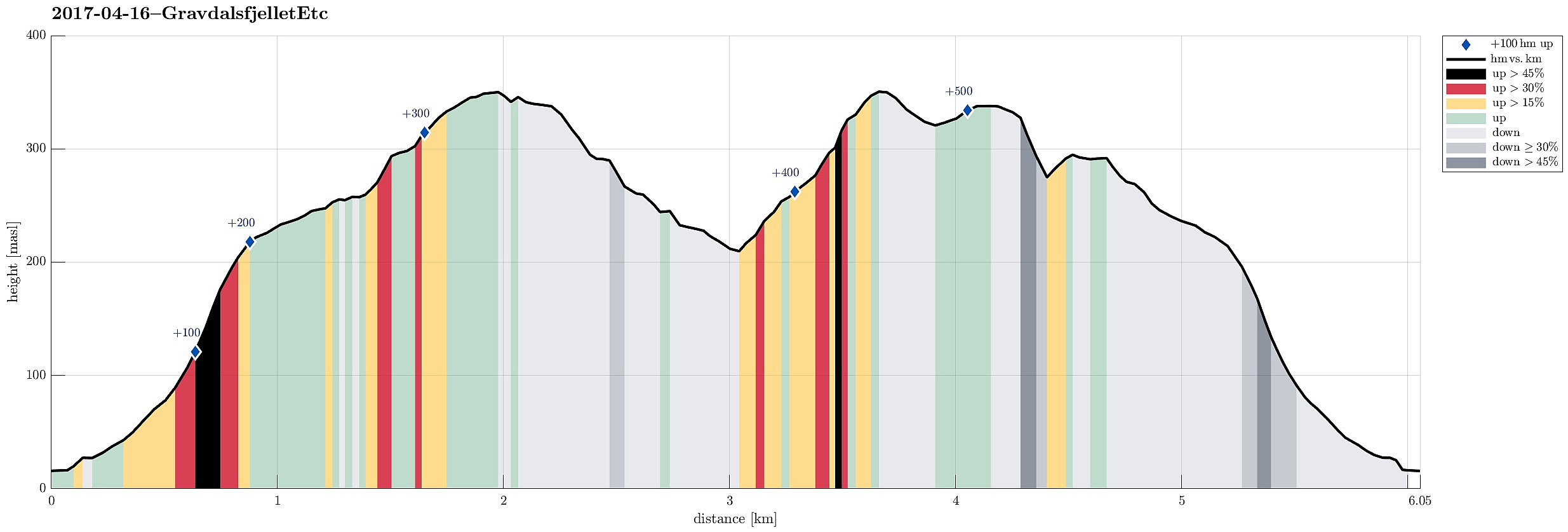 We took the car to Laksevåg/Lyngbø and parked right at the beginning of Eliasmarken. From there, we started to walk; first up to Lyngbøveien and so further into Nygårdslien (and upwards this road). At the upper end of Nygårdslien, we connected to the hiking path, which starts/ends there. Quickly, we ascended (moderately steeply) to the height where the path starts to flatten out towards the saddle between Gravdalsfjellet (in the southwest) and Damsgårdsfjellet (in the northeast). At the point, where four paths meet, we turned right (into southwestern direction) and continued our ascent to Gravdalsfjellet. Shortly later, we arrived at the top of Gravdalsfjellet and enjoyed an all-around view from there. From there, we first walked into the direction of Viggohytten, but turned left >>>
Gaustadfjellet, Litlafjellet, Bårafjellet, Øyjordsfjellet
- Date:
- 14.04.2017
- Characteristic:
- Hillwalk
- Duration:
- 3:45h
- Distance:
- 7.3km
 With a very promising spring day ahead, we decided to try some new top(s) in the north of Meland, i.e., Gaustadfjellet and others. We took road E39 northwards from Bergen, crossed Nordhordlandsbrua, and connected then to the small road #245 that departs from the road to Frekhaug right after the bridge to Meland. We then followed this narrow road northwards until we arrived at Ådland. We parked, where Kyrkjesundvegen departs in northern direction.
On the map, we had seen that approximately 200m south of this point, a path up to Gaustadfjellet should be possible to find---getting there, however, required a little bit of good orientation (and one more look at the map, actually). Once on this path, however, the ascent to Gaustadfjellet is straight-forward and quick. From the top of Gaustadfjellet, >>>
With a very promising spring day ahead, we decided to try some new top(s) in the north of Meland, i.e., Gaustadfjellet and others. We took road E39 northwards from Bergen, crossed Nordhordlandsbrua, and connected then to the small road #245 that departs from the road to Frekhaug right after the bridge to Meland. We then followed this narrow road northwards until we arrived at Ådland. We parked, where Kyrkjesundvegen departs in northern direction.
On the map, we had seen that approximately 200m south of this point, a path up to Gaustadfjellet should be possible to find---getting there, however, required a little bit of good orientation (and one more look at the map, actually). Once on this path, however, the ascent to Gaustadfjellet is straight-forward and quick. From the top of Gaustadfjellet, >>>
Veten i Åsane via Skagen
- Date:
- 13.04.2017
- Characteristic:
- Hillwalk
- Duration:
- 3:00h
- Distance:
- 9.4km
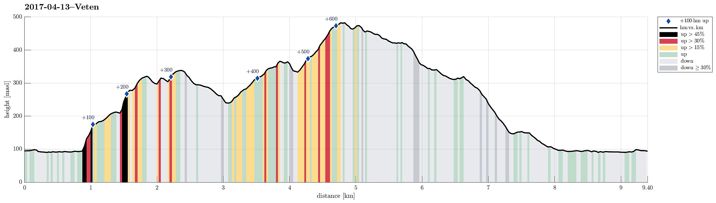 Inspired by a recent hike of a colleague , I decided for a tour up to Veten i Åsane today. I found the idea to include also Skagen i Åsane attractive and thus planned for a little round, accordingly.
To start, I took the car to Åsane (along E39) and then, near IKEA, I connected to a very narrow, small road, which leads towards Dalabygda in the northwest of Langavatnet (where the old post-path starts to ascend between Høgstefjellet and Veten i Åsane). Next to the few houses there, a parking place has been built as a convenient starting point for hikers along the old post-path.
In order to make the ascent to Skagen a little more interesting, I thought that I could try to go there via the smaller hilltops, which one can find between Langavatnet and Skagen, i.e., Glanten, Alteret, and Husaberget. From looking at the >>>
Inspired by a recent hike of a colleague , I decided for a tour up to Veten i Åsane today. I found the idea to include also Skagen i Åsane attractive and thus planned for a little round, accordingly.
To start, I took the car to Åsane (along E39) and then, near IKEA, I connected to a very narrow, small road, which leads towards Dalabygda in the northwest of Langavatnet (where the old post-path starts to ascend between Høgstefjellet and Veten i Åsane). Next to the few houses there, a parking place has been built as a convenient starting point for hikers along the old post-path.
In order to make the ascent to Skagen a little more interesting, I thought that I could try to go there via the smaller hilltops, which one can find between Langavatnet and Skagen, i.e., Glanten, Alteret, and Husaberget. From looking at the >>>
Short walk in Kanadaskogen
- Date:
- 02.04.2017
- Characteristic:
- Hike
- Duration:
- 1:00h
- Distance:
- 3.5km
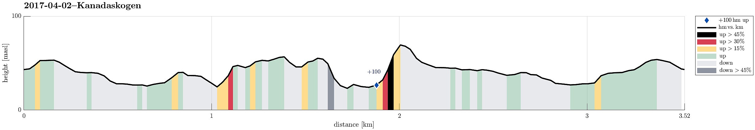 We simply headed for Kanadaskogen (from Varden) and explored some paths aside of the more regularly used ones. After all, this was just a short walk in order to get some fresh air. How nice to have Kanadaskogen right around the corner! :-)
Selected photos are available as Google photo album .
See also the related FB-page Hiking around Bergen, Norway .
We simply headed for Kanadaskogen (from Varden) and explored some paths aside of the more regularly used ones. After all, this was just a short walk in order to get some fresh air. How nice to have Kanadaskogen right around the corner! :-)
Selected photos are available as Google photo album .
See also the related FB-page Hiking around Bergen, Norway .
