Archiv - Nach Datum
Archiv - Nach Aktivität
-
Andere Tour (1)
- Kayaking (1)
-
Andere Wintertour (4)
- Schneeschuhtour (4)
-
Fahrradtour (137)
- Fahrradtour Straße (9)
- Fahrradtour gemischt (51)
-
Fußtour (740)
- Bergtour (363)
- Jogging (18)
- Spaziergang (89)
- Wanderung (270)
-
Skitour (4)
- Tourenskilauf (4)
Archiv - Nach Geografie
Peakbookfreunde


Gesammelte Listen
-
Bergen ≥ 50m pf. og ≥ 100 m.o.h.
(87/89)
 97%
97% -
Most dominating tops of the Bergen peninsula
(68/75)
90%
-
Utvalgte topper og turmål i Bergen
(316/352)
89%
-
Alle topper i Bergen
(357/400)
89%
-
Opptur Bergen
(100/113)
88%
-
De syv fjell rundt Bergen
(6/7)
85%
-
Sund ≥ 50m pf.
(14/18)
77%
-
Os ≥ 50m pf.
(25/34)
73%
-
Søyler (fastmerker) i Bergen
(68/100)
68%
-
Fjell ≥ 50m pf.
(21/32)
65%

Anekletten on Toftøyna
- Datum:
- 29.01.2017
- Tourcharakter:
- Wanderung
- Tourlänge:
- 2:00h
- Entfernung:
- 7,2km
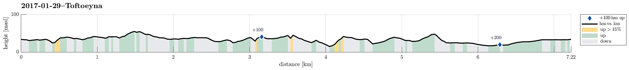 I drove westwards from Bergen and over to Sotra, where I turned right (and northwards), following road #561, first through Knappskog and then through Ågotnes. A bit further north, I passed over Misje, before connecting to Toftøyna. There, I drove almost to the very north of this little island (near Torsteinsvik) and parked the car right where a little road called Husdalen connects with Toftøyvegen (road #561).
On the other side of the street (on the eastern side), a path extends from the main road, leading eastwards. When crossing over a little dip, that connects to Orrdalsvatnet further south, I did not immediately see the continuation of the path and followed (instead) another path, which leads in northeastern direction. I followed this path until an area, where maybe some scouts are >>>
I drove westwards from Bergen and over to Sotra, where I turned right (and northwards), following road #561, first through Knappskog and then through Ågotnes. A bit further north, I passed over Misje, before connecting to Toftøyna. There, I drove almost to the very north of this little island (near Torsteinsvik) and parked the car right where a little road called Husdalen connects with Toftøyvegen (road #561).
On the other side of the street (on the eastern side), a path extends from the main road, leading eastwards. When crossing over a little dip, that connects to Orrdalsvatnet further south, I did not immediately see the continuation of the path and followed (instead) another path, which leads in northeastern direction. I followed this path until an area, where maybe some scouts are >>>
Svartaberget in nice winter sun
- Datum:
- 14.01.2017
- Tourcharakter:
- Bergtour
- Tourlänge:
- 3:00h
- Entfernung:
- 9,0km
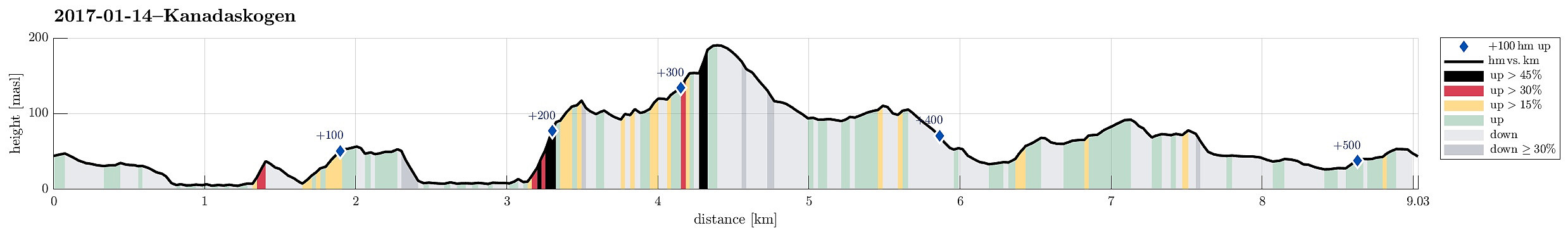 We started in Varden and used Bregnestien to get close to Gjeddevatnet as soon as possible.
Once had descended to Gjeddevatnet (basically to the place, where occasionally some bath in warmer months), we continued along the water (in northward direction). We kept going along the water, passing by Skogadotten and Skaget until we reached Gjerdsvika. Before going further to Bjørndalsvatnet (over the heights southwest of Hesjaholtet), we first made a short visit to Fureneset (very nice in the winter sun!). We then crossed over the heights west of Hesjaholtet in order to connect to Bjørndalsvatnet. We came back down to the water basically directly west of the northern most block of Hesjaholtet and managed to continue along the water (even though there is a very steep cliff to its eastern side). >>>
We started in Varden and used Bregnestien to get close to Gjeddevatnet as soon as possible.
Once had descended to Gjeddevatnet (basically to the place, where occasionally some bath in warmer months), we continued along the water (in northward direction). We kept going along the water, passing by Skogadotten and Skaget until we reached Gjerdsvika. Before going further to Bjørndalsvatnet (over the heights southwest of Hesjaholtet), we first made a short visit to Fureneset (very nice in the winter sun!). We then crossed over the heights west of Hesjaholtet in order to connect to Bjørndalsvatnet. We came back down to the water basically directly west of the northern most block of Hesjaholtet and managed to continue along the water (even though there is a very steep cliff to its eastern side). >>>
Gullaksdalen from Loddefjord
- Datum:
- 07.01.2017
- Tourcharakter:
- Wanderung
- Tourlänge:
- 2:00h
- Entfernung:
- 7,7km
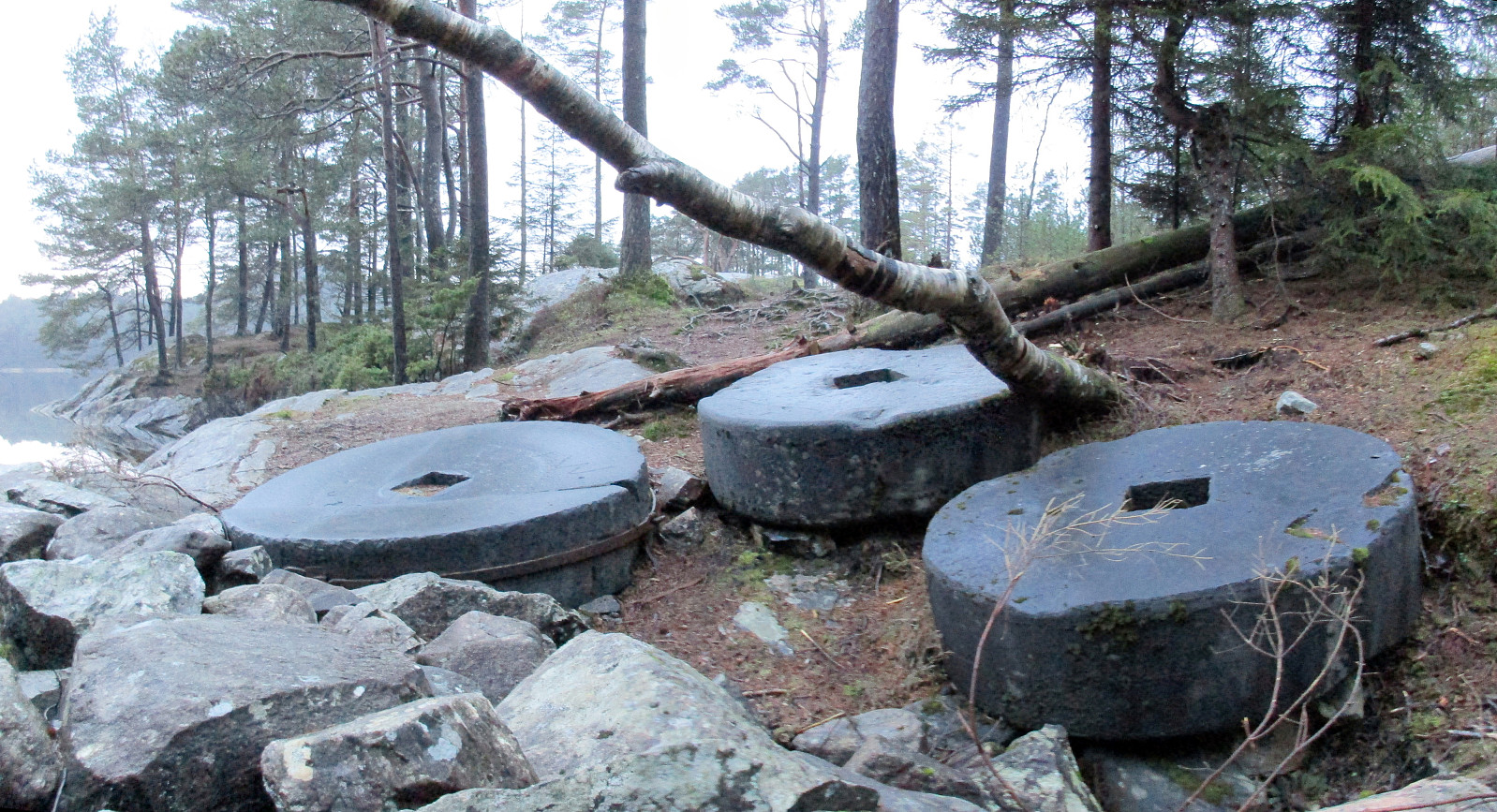 We parked in Frieda Fasmers vei, near Loddefjord, and started in parallel to the highway, rounding Storavatnet on its northern side. Where road 555 enters Harafjelltunnelen, we followed a major gravel road that turns southwards and leads to a place called Slettebakksmyra. There, at two points, other gravel roads depart from the one we took (at the first junction, we continued straight ahead and at the second, we turned left and upwards, following a sign to Gullaksdalen). We then continued on the gravel road until it ends. There, one can read about the history of Gullaksdalen. We then continued a few meters further, reaching a nice place with great view of Småvatnet. Only meters from there, we could see some of the historic ruins, which were described on the information board at the end >>>
Løvstakken via Nova
- Datum:
- 01.01.2017
- Tourcharakter:
- Bergtour
- Tourlänge:
- 1:15h
- Entfernung:
- 3,3km
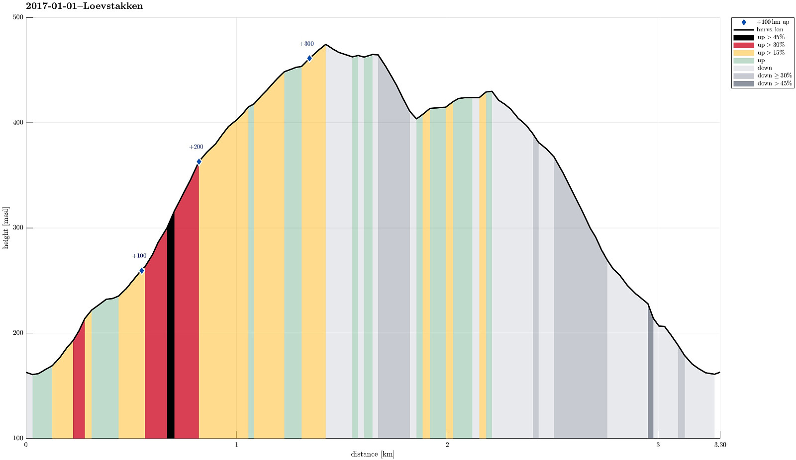 We parked the car at the parking place right above Litlavatnet (along Krohnegården street in upper Fyllingsdalen) and had the plan to try out a new route up Løvstakken. And so we did! :-) We started along the usual path, which leads firmly upwards (in northeastern direction towards the saddle between Ravnefellet and Løvstakken). After having past the little waterfall on our right, we found the right spot, where a less used path leaves to the right. We followed this minor path, which makes a comparably large half-circle around the waterfall (and above it), turning into a southward direction. Right above the waterfall, one needs to expect wet terrain; so good shoes are helpful, when choosing this alternative. From there, we then continued to ascend (following the kind of diagonally oriented >>>
