Archive - Date
Archive - Activity
-
Bike trip (137)
- Bike trip - mixed (51)
- Bike trip - road (9)
-
Other trip (1)
- Kayaking (1)
-
Other winter trip (4)
- Snowshoe trip (4)
- Ski trip (4)
- Trip by foot (740)
Archive - Geography
Peakbook-Friends


Collected lists
-
Bergen ≥ 50m pf. og ≥ 100 m.o.h.
(87/89)
 97%
97% -
Most dominating tops of the Bergen peninsula
(68/75)
90%
-
Utvalgte topper og turmål i Bergen
(316/350)
90%
-
Alle topper i Bergen
(357/398)
89%
-
Opptur Bergen
(100/113)
88%
-
De syv fjell rundt Bergen
(6/7)
85%
-
Sund ≥ 50m pf.
(14/18)
77%
-
Os ≥ 50m pf.
(25/34)
73%
-
Søyler (fastmerker) i Bergen
(68/100)
68%
-
Fjell ≥ 50m pf.
(21/32)
65%

Løvstakken from Fjøsanger
- Date:
- 26.12.2017
- Characteristic:
- Hillwalk
- Duration:
- 2:30h
- Distance:
- 5.9km
 We parked near the supermarket at Fjøsanger and walked first a bit up towards the farm Fjøsanger. Before getting there, we connected to a gravel path that runs mostly parallel to the mountain and walked along this one until the forest starts to open up on the left side. At the very edge of the forest, another path then continues steeply upwards and we used this to get "to the next level" (the still relatively new path which maybe later will be connected with the new Løvstien all around Løvstakken's eastern side). We then walked this path to its current end (there is a little hut for having a break). From there, we then continued through the forest, again, getting up to Mindebakken (a little hill, northeast of Gullsteinen). Since Mindebakken is comparably steep on its western >>>
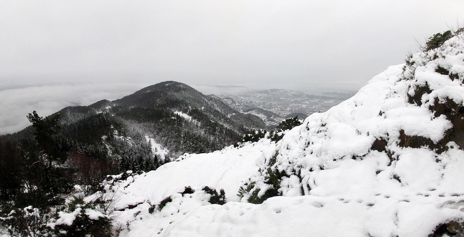
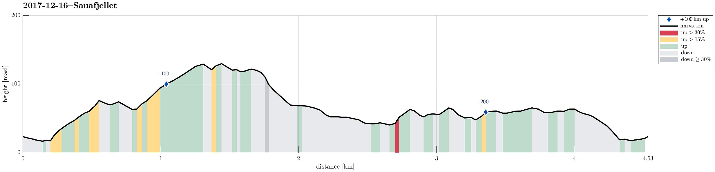
Sauafjellet
- Date:
- 16.12.2017
- Characteristic:
- Hillwalk
- Duration:
- 2:00h
- Distance:
- 4.5km
 We took the car to Sotra and there to Fjæreide (near Knappskog). We parked near the place where seemingly also the bus turns around (more or less in the middle between Fjæreidpollen in the NE and Fjæreidvatnet in the SW). We then walked first for a few meters down the road which leads down to the water (Fjæreidpollen/Smalneset), before then turning left (following a sign from Kyststien). Within short we were in the snow and soon after we departed from the path towards Spjeldsfjellet (our plan was to get up Sauafjellet first). After quickly ascending to Fagrevollen, we connected to a ridge, which leads up to Sauafjellet in western direction. At Sauafjellet, we enjoyed some great views towards the Atlantic! We then decided to head towards Spjeldsfjellet, even though it was clear that >>>
Katlaberget
- Date:
- 21.10.2017
- Characteristic:
- Hillwalk
- Duration:
- 2:00h
- Distance:
- 4.5km
 We started this little hike on Ferstadvegen in Os, south of Bergen. First we followed the road, which winds left and right into an overall southeastern direction. After a few turns of the road, one can find the first sign, which invites to leave the road and ascend to Katlaberget on a proper path. After all, this would be the spot, where we later come back to the road after our little round over Katlaberget. To actually make this a round, we first continued on the road even further, now going a bit down towards the sea. About two major turns later, we eventually left the road and followed another path, which also leads to the top of Katlaberget. On Katlaberget, we first enjoyed some views from the actual top, before we then followed "the other" path back. This, actually, brought >>>
Ørnafjellet and Lyderhorn on a lovely autumn day!
- Date:
- 18.10.2017
- Characteristic:
- Hillwalk
- Duration:
- 3:00h
- Distance:
- 7.2km
 We started at the parking area right next to Gravdalsvatnet and followed first Gravdalsveien upwards in order to find the path that would bring us to Ørnafjellet. After having passed a few new buildings (with an amazing view!), we crossed over some intermediate height to connect to a small place, where a little football field is established. From there, the path upwards to Ørnafjellet starts (in its middle then called "Mørdarbakke"). This path is not used a lot and it is generally wet (and also a bit steep). Quickly, we arrived at the saddle, where we turned left in order to continue to Ørnafjellet. We first crossed over a little hill in front of Ørnafjellet, before we switched over to the northern ridge of Ørnafjellet, ascending to its top along it. Even though Ørnafjellet >>>
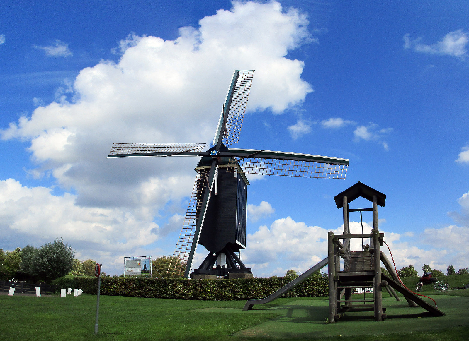
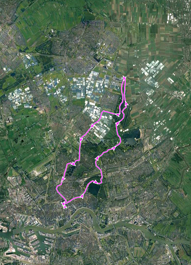
Kinderdijk
- Date:
- 23.09.2017
- Characteristic:
- Bike trip
- Duration:
- 3:00h
- Distance:
- 35.8km
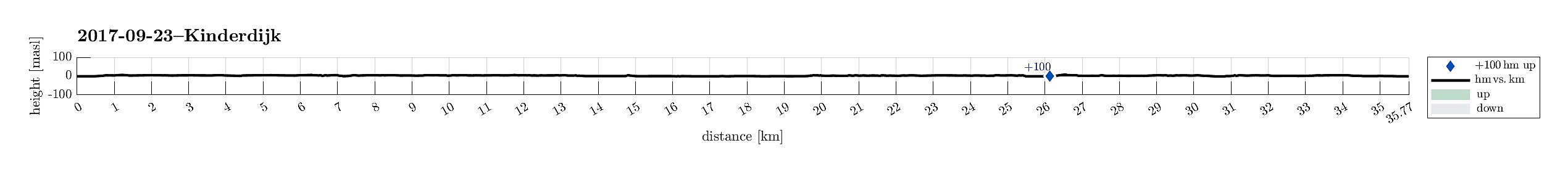 We started from the center of Rotterdam and cycled first into southeastern direction, crossing the new Maas via Erasmusbrug. We then passed by the stadion of Feyenoord, continuing into southeastern direction, in the south of the new Maas. East of the stadion, we turned into eastern direction. After having come to the eastern side of the highway A16, we got onto the dam in the south of the Maas and followed it until the point, where the three rivers Lek, Noord, and Nieuwe Maas come together. There, we took a little ferry to get over to Kinderdijk on the southern side of the Lek. We then explored the cultural heritage site Kinderdijk with its historic wind mills, before we got back to the river, crossing over it with the car ferry to the north. Once there, we basically cycled back into >>>
Rotterdam-exploration 08: To Brielle and back
- Date:
- 10.09.2017
- Characteristic:
- Bike trip
- Duration:
- 5:00h
- Distance:
- 69.8km
 We started from the center of Rotterdam and cycled first northwards, into the direction of the airport of Rotterdam. Near the airport we turned left, then mostly in western direction, and soon reached the Old Overschie at the knee of the Delftsche Schie. We then crossed over to another city part, Kethel en Spaland. Crossing the highway A4, next, we came through city part Holy, continuing further to the large recreation area Broekpolder. Circling this area in its east and south, we ended up on Broekpolderweg, cycling parallel to highway A20 into western direction and towards Maassluis. In Maassluis, we found our way southwards to Deltaweg from where a ferry took us over the Maas to the southern side. There, we crossed Rozenburg to get onto large bridges, which led us over Calandkanaal, >>>
Rotterdam-exploration 07: Via Kralingse Plas to Rottemeren
- Date:
- 03.09.2017
- Characteristic:
- Bike trip
- Duration:
- 3:00h
- Distance:
- 37.2km
 We started from the center of Rotterdam, cycling eastwards to get to Kralingse Plas, i.e., a really nice recreational area quite near to the city center. From its northeastern "corner", we then continued northwards in order to connect to the Rotte and the nice dams alongside it. Once there, we cycled along the Rotte in northwards direction and arrived at Rottemeren (on its eastern side) soon. We cycled all the way northwards to the point, where the highway A12 is crossing the Rotte. There we switched to the other side (the western side) and started our return to Rotterdam from there. We started to cycle along the Rotte, again (now on its western side) until we took a turn to the right in the southeast of Bleiswijk. Leaving the Rotte behind us, we followed Merenweg in the south >>>
Rotterdam-exploration 06: to Gouda and back
- Date:
- 27.08.2017
- Characteristic:
- Bike trip
- Duration:
- 4:00h
- Distance:
- 71.1km
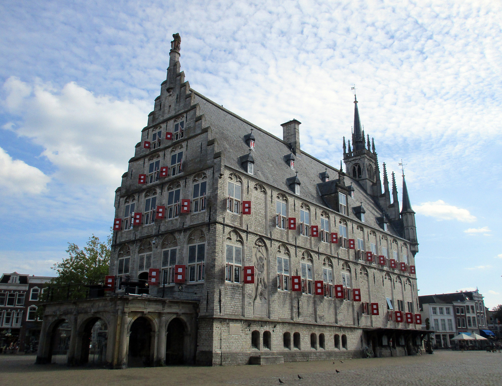 This sixth exploration of Rotterdam by bike brought me to the northeast of Rotterdam, in particular to Gouda. I cycled first towards the east (into the direction of Kralingse Plas), but turned left once I had crossed the Rotte. Then, I was basically following the Rotte into northeastern direction all the way to Rottemere, where I departed from the main cycling route (which leads further north) and crossed over to Zevenhuizen. From there, I continued into northeastern direction, crossing the highway A12, also, until I came to Waddinxveen. There, I changed into eastern direction, which brought me to Reeuwijk, right next to the lakes north of Gouda. I then circled 's-Gravenbroek in the north, before I crossed between Elfhoeven and Kleine Elfhoeven towards the south and Gouda. The old center >>>
Rotterdam-exploration 05: along the Oude Maas to Dordrecht
- Date:
- 26.08.2017
- Characteristic:
- Bike trip
- Duration:
- 5:00h
- Distance:
- 72.6km
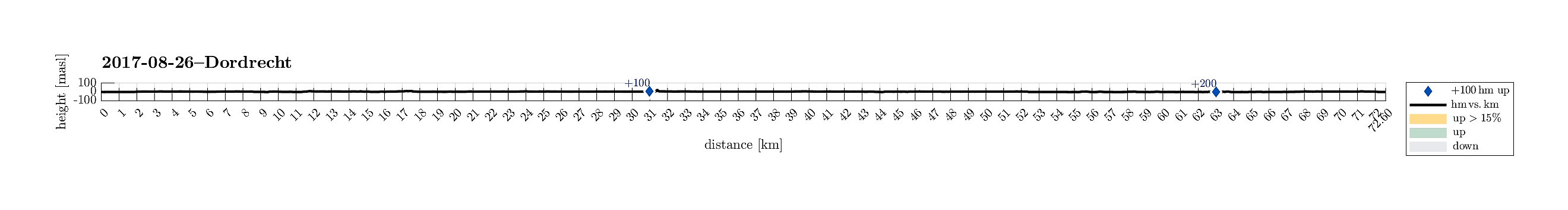 This fifth exploration of Rotterdam by bike brought me to the southeast of Rotterdam. I cycled first towards Schiedam in the west of Rotterdam. At Vijfsluizen, I turned left (into southern direction) and headed towards the Benelux-tunnel that connects to the south underneath the Nieuwe Maas. It's really cool that cyclists have their own tunnel, in fact! On the souther side, I biked by Pernis, before I came to the enormous traffic line, which leads out to Europoort in the west (train tracks plus two highways next to each other). I followed this traffic line a bit towards the west so that I could circle Hoogvliet on its western side. After all, this also brought me towards the Oude Maas, along which I had planned to cycle towards Dordrecht. Doing so, I enjoyed the nice biking paths along >>>
Rotterdam-exploration 04: to the Atlantic and back
- Date:
- 19.08.2017
- Characteristic:
- Bike trip
- Duration:
- 6:00h
- Distance:
- 89.4km
 This fourth exploration of Rotterdam on bikes brought us to the west of Rotterdam. We started in Rotterdam Centrum and headed westwards, first. We crossed the Delfshavensche Schie and cycled then towards Schiemond, before we changed direction (towards Schiedam). Passing by Merwehaven, we came to Schiedam, where we turned left (towards the south). At the Nieuwe Maas we then turned right, again, following then the Westfrankelandsedijk towards the west. Passing by Volkspark, we came to Vijfsluizen from where we connected to Vlaardingen. In the west of Vlaardingen, we found a nice biking path through the green and open land there. That brought us to Maassluis, where we connected to the dam (on the northern side of the Nieuwe Maas). We then followed the dam (against some very strong headwinds!) >>>
