Archive - Date
Archive - Activity
-
Bike trip (137)
- Bike trip - mixed (51)
- Bike trip - road (9)
-
Other trip (1)
- Kayaking (1)
-
Other winter trip (4)
- Snowshoe trip (4)
- Ski trip (4)
- Trip by foot (740)
Archive - Geography
Peakbook-Friends


Collected lists
-
Bergen ≥ 50m pf. og ≥ 100 m.o.h.
(87/89)
 97%
97% -
Most dominating tops of the Bergen peninsula
(68/75)
90%
-
Utvalgte topper og turmål i Bergen
(316/350)
90%
-
Alle topper i Bergen
(357/398)
89%
-
Opptur Bergen
(100/113)
88%
-
De syv fjell rundt Bergen
(6/7)
85%
-
Sund ≥ 50m pf.
(14/18)
77%
-
Os ≥ 50m pf.
(25/34)
73%
-
Søyler (fastmerker) i Bergen
(68/100)
68%
-
Fjell ≥ 50m pf.
(21/32)
65%

Skarafjellet and Lyseskarfjellet (Fanafjellet)
- Date:
- 25.09.2016
- Characteristic:
- Hillwalk
- Duration:
- 2:00h
- Distance:
- 6.1km
 We drove to Fana, south of Bergen, and took the road, which leads towards Krokeidet, along the southern shore of Fanafjorden. Near Salbu, we found a place, where we could leave the car, and started our hike from there. We passed the houses with numbers 264 and 260 (right there, it was not 100% obvious, how we could optimally connect to the forrest road, which we had planned to find. But continuing around the houses led us to the spot, where the forrest road starts (in southwestern direction). From there, it was "straight-forward", then---at least in the beginning. We followed the forrest road, which wind back and forth, while leading up the northern side of Fanafjellet. While the first few meters of this little forrest road are not really inviting, the picture changes quickly, >>>
Flatafjellet from Helle
- Date:
- 17.09.2016
- Characteristic:
- Hillwalk
- Duration:
- 5:45h
- Distance:
- 16.7km
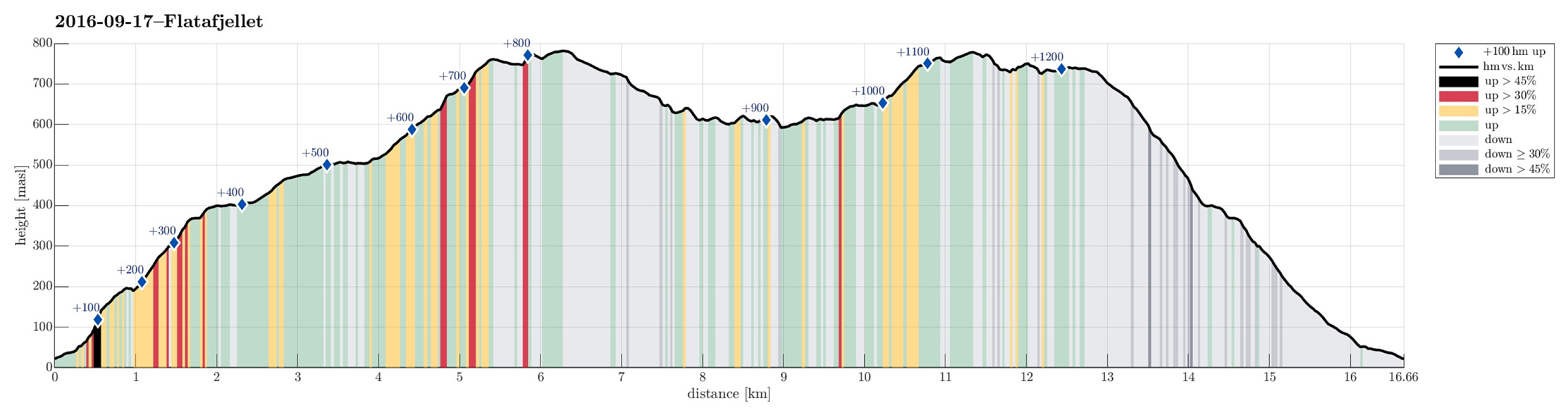 We took the E16 from Bergen towards Voss. Shortly after passing by Stanghelle, right after driving through Helletunnelen (and before entering Dalevågtunnelen), we left E16 to the left and continued on Sætravegen (for only few meters), which first goes parallel to E16, but then over it (over the tunnel-entry to Dalevågtunnelen) and to the other side. Driving Sætravegen up a little (to the to or three houses, there), we learned that it was not appreciated that we would park anywhere there---instead, we found a very good parking spot right next to E16 (but on its southeastern side). From there, we started walking, first Sætravegen up. At the upper end of the few houses, a trail leaves to the left. We took this trail, which leads one quickly upwards and into Espeligjelet (one could also >>>
Skardalsfjellet via Brattlandsfjellet
- Date:
- 11.09.2016
- Characteristic:
- Hillwalk
- Duration:
- 3:30h
- Distance:
- 10.4km
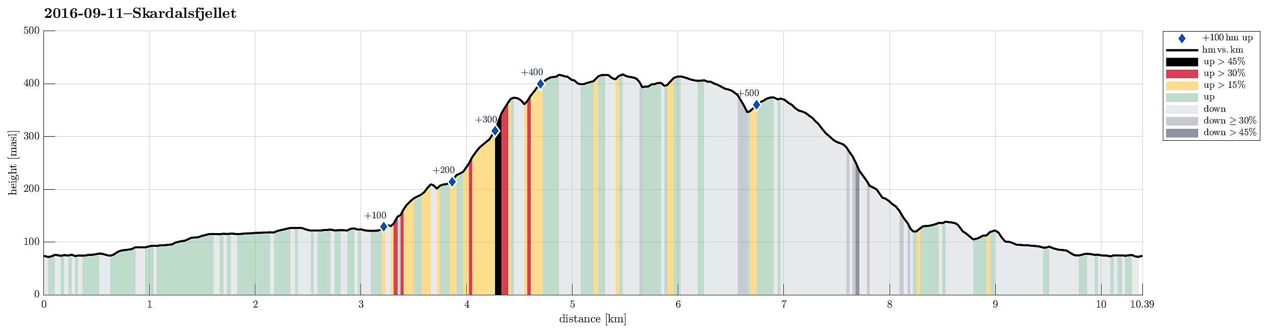 We parked near Dyngelandsvatnet along Dyngelandsvegen and walked along the private road that passes south of the lake (Dyngelandsvatnet) and then leads further to Myrdalsvatnet, where it turns left, continuing then in mostly northern direction from there towards Langavatnet, west of Flåfjellet. In a pretty wet area, where lots of water is coming down from high above (from between Stordalsfjellet and Flåfjellet), the gravel road ends and one continues along the valley on something that is largely a underwater hiking path . One passes Langavatnet on the west, following more or less along the water line. At the northern end of this lengthy lake, we crossed over to the other, eastern side---connecting to the place, where we had come down during an earlier hike . Now, we ascended through the wild---right underneath >>>
Arboretet in Milde
- Date:
- 11.09.2016
- Characteristic:
- Walk
- Duration:
- 2:00h
- Distance:
- 4.7km
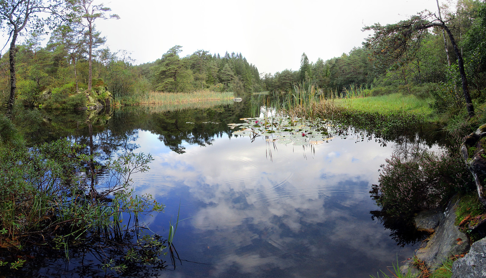 We parked at the Dalsmyra parking at the northwestern end of the arboretum. From there, it's an easy walk along a simple forrest road (mostly eastwards, first), before one gets into the heart of the arboretum. After passing a covered sitting area, we turned left---circling halfways around Mørkevatnet (with some nice views over this little lake). We then ascended the few meters upwards to enter the garden with many different Rhododendron-plants. After having enjoyed some nice views over Vestrepollen in the northwest, we turned right and continued in southeastern direction towards Langemyra---there, we connected to a path the lead us outwards to Store Brandaneset. At the southeastern end of Store Brandaneset, we enjoyed a really nice place directly at the sea. From there, we then returned---first >>>
Tørviknuten and Visoldo
- Date:
- 04.09.2016
- Characteristic:
- Hillwalk
- Duration:
- 6:30h
- Distance:
- 17.6km
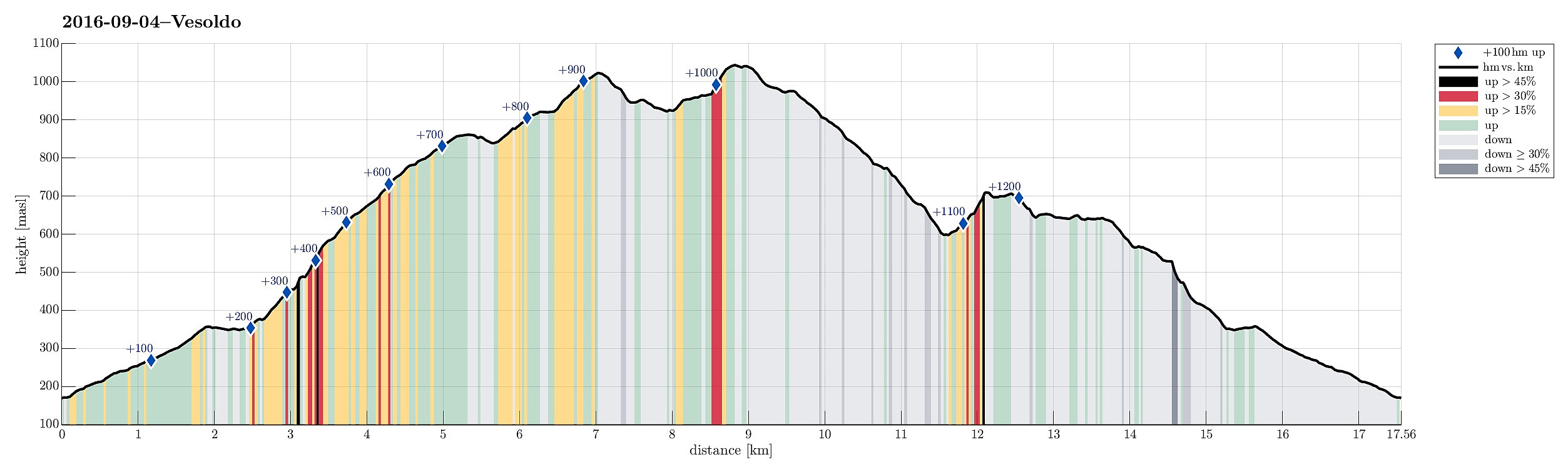 We took FV7 from Bergen towards Hardanger and turned right in Nordheimsund, following road 49 from there. We passed Tørvikbygd and when we had Eidesvatnet to our left, we entered a very small and narrow road, leading up to Åse. We parked a few meters above the farm and started to walk along a forrest road that extends further up from there. As we got higher on this forrest road, we started to pay attention to where a suitable path would take off (to the left and up). When passed Åsstølen (on the right), we started to be particularly curious, but still no inviting opportunity appeared on our left-hand side. Eventually, we decided to walk all the forrest road up (and over a small saddle right west of Hågeli), leading towards a place, where they obivously deal with some sheep, or the >>>
Algrøyna, Smalaneset
- Date:
- 03.09.2016
- Characteristic:
- Hillwalk
- Duration:
- 2:30h
- Distance:
- 4.5km
 We drove westwards from Bergen towards the outer islands and stopped at Algrøyna (basically at the very last bus stop, there). From there, we continued into western direction, looking into Nøtevika, first. We then crossed over to the relatively large peninsula of Algrøyna, which lies between Breivika in the north and Kungvika in the south. We followed a well-marked path westwards as soon as we had reached this peninsula, following the northern coastline. Relatively quickly, we proceeded towards the outermost tip of this peninsula, Smalaneset, enjoying many great views already on the way out there. After a short rest, we returned---this time following the southern shore, along Kungvika. Back to the street (Kungvikvegen), we did not have long to go, before we were back to the car. It's >>>
