Archiv - Nach Datum
Archiv - Nach Aktivität
-
Andere Tour (1)
- Kayaking (1)
-
Andere Wintertour (4)
- Schneeschuhtour (4)
-
Fahrradtour (137)
- Fahrradtour Straße (9)
- Fahrradtour gemischt (51)
-
Fußtour (740)
- Bergtour (363)
- Jogging (18)
- Spaziergang (89)
- Wanderung (270)
-
Skitour (4)
- Tourenskilauf (4)
Archiv - Nach Geografie
Peakbookfreunde


Gesammelte Listen
-
Bergen ≥ 50m pf. og ≥ 100 m.o.h.
(87/89)
 97%
97% -
Most dominating tops of the Bergen peninsula
(68/75)
90%
-
Utvalgte topper og turmål i Bergen
(316/350)
90%
-
Alle topper i Bergen
(357/398)
89%
-
Opptur Bergen
(100/113)
88%
-
De syv fjell rundt Bergen
(6/7)
85%
-
Sund ≥ 50m pf.
(14/18)
77%
-
Os ≥ 50m pf.
(25/34)
73%
-
Søyler (fastmerker) i Bergen
(68/100)
68%
-
Fjell ≥ 50m pf.
(21/32)
65%

Løvstakken (steepest way up)
- Datum:
- 30.05.2015
- Tourcharakter:
- Bergtour
- Tourlänge:
- 1:06h
- Entfernung:
- 3,6km
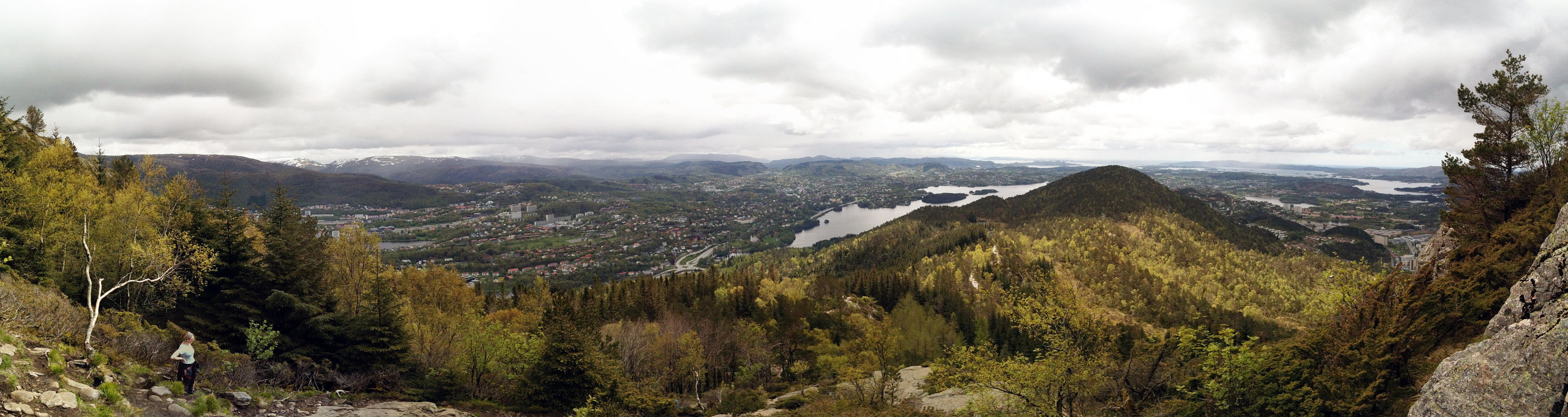 Starting from Kirsten Flagstads vei, we first went up Rosenlundveien (in the direction towards Strutsefarmen). Before actually getting to the farm, we turned left and continued steeply upwards until the street makes a larger swing to the right. There, one can leave the street and continue, first between some trees, and then under a line (telephone line?), more or less directly up towards Løvstakken. Up via a really steep path, one quickly gets to the top of Løvstakken (it took us less than 25 mins. to ascend, making about 360 height meters in this time). From the top, we descended first in the direction of Gullsteinen, before we turned right (again into the direction towards Strutsefarmen). But also this time, we did not continue all the way to the farm, but left the main path and found >>>
Geitanuken
- Datum:
- 25.05.2015
- Tourcharakter:
- Bergtour
- Tourlänge:
- 2:45h
- Entfernung:
- 8,3km
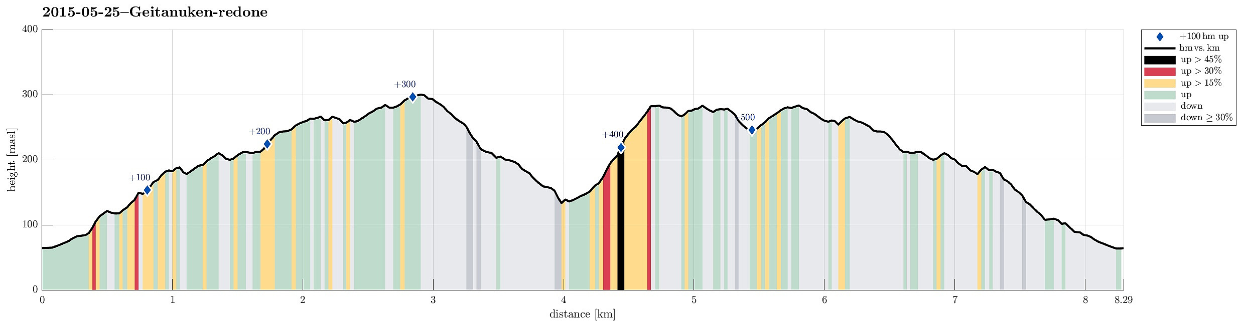 We started from Nordre Toppe and ascended quickly to the ridge in the west that leads up to Geitanuken (via Vedskaråsen and Novvarden). Due to recent rain, the path was slippery and wet. Still, this hike up Geitanuken from the northwest is nice and easy and very enjoyable! Also, one can enjoy several nice views over Byfjorden and Askøy, etc. Once on Geitanuken, we continued towards Åsane, i.e., towards south-southeast, descending via a path that is steeper than what we had walked up (still no problem at all -- just slippery after the rain). We got down to Myrdalskogen and passed by the houses through the near forrest -- staying close to the houses, though. From a large turn of Myrdalskogen road, we turned left (in northeasterly direction), descending steeply first and ascending then >>>
Såtefjellet
- Datum:
- 23.05.2015
- Tourcharakter:
- Bergtour
- Tourlänge:
- 4:30h
- Entfernung:
- 12,3km
 Driving to Osterøy via the impressive toll bridge was easy and quick from Bergen. Our plan was to start near Stokko and to ascend first to a forest road that goes along the fjord at some 100 meters above sea-level and which we had seen on the map in advance. Instead, we parked -- accidentally -- where the road crosses Kjindalen and ascended from there. It seemed to us that others have done that before -- at least it looked like steps in the steep terrain. The valley we ascended through is very steep and it was quite slippery due to the recent rain. When it started to open up a little (Erdalen?) and when we also had the impression that we should have reached the height of the forest road, we continued to the northeast, parallel to the fjord, to find the forest road. It turned out that >>>
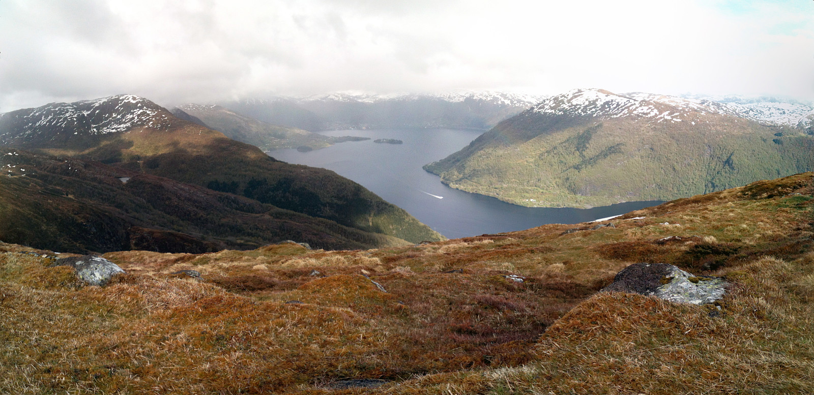
Leirvågfjellet i Fana
- Datum:
- 16.05.2015
- Tourcharakter:
- Bergtour
- Tourlänge:
- 1:30h
- Entfernung:
- 4,6km
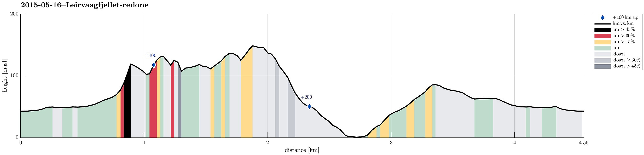 We parked at the parking place at Korsneset, right where the (narrow) road enters a military area. From there, we first followed a forest road northwards, before turning to the right, where there seemed to be a path. The eastwards path passed north of Moldstigahaugen, descending again on the other, eastern side of this hill. We decided to ascend to the top of Moldstigahaugen (from the eastern side). Afterwards, we followed a (rather less than more visible) path northwards towards Leirvågfjellet. The view from this top is quite nice in all directions! We continued further northwards, finding a possibility to descend down to the saddle between Leirvågfjellet and Kampen. From there we followed a reasonably well visible path towards the north-northwest (below the steep western slope of >>>
Ørnafjellet i Bergen
- Datum:
- 09.05.2015
- Tourcharakter:
- Bergtour
- Tourlänge:
- 2:00h
- Entfernung:
- 4,7km
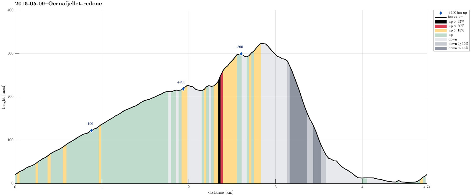 We parked north of Gravdal (near Nutec) and followed the road up the northern slope of Lyderhorn (until where it enters the military area). We then followed the path along the southern fence of this area, heading southeast towards Ørnafjellet. From the top of Ørnafjellet, we enjoyed the views over Byfjorden (to the north) and to Lyderhorn and Damsgårdsfjellet (to the south and east). We then aimed at finding the path down the eastern slope of Ørnafjellet, directly to Gravdal, but we left the path, which we had taken up Ørnafjellet much too early. This made us descend through a moderately steep forest (without any path). While doable, this part was not most enjoyable and it should be recommended to follow the actual path downwards. Once down in Gravdal, we returned to the car along >>>
Slættaratindur
- Datum:
- 02.05.2015
- Tourcharakter:
- Bergtour
- Tourlänge:
- 3:30h
- Entfernung:
- 3,3km
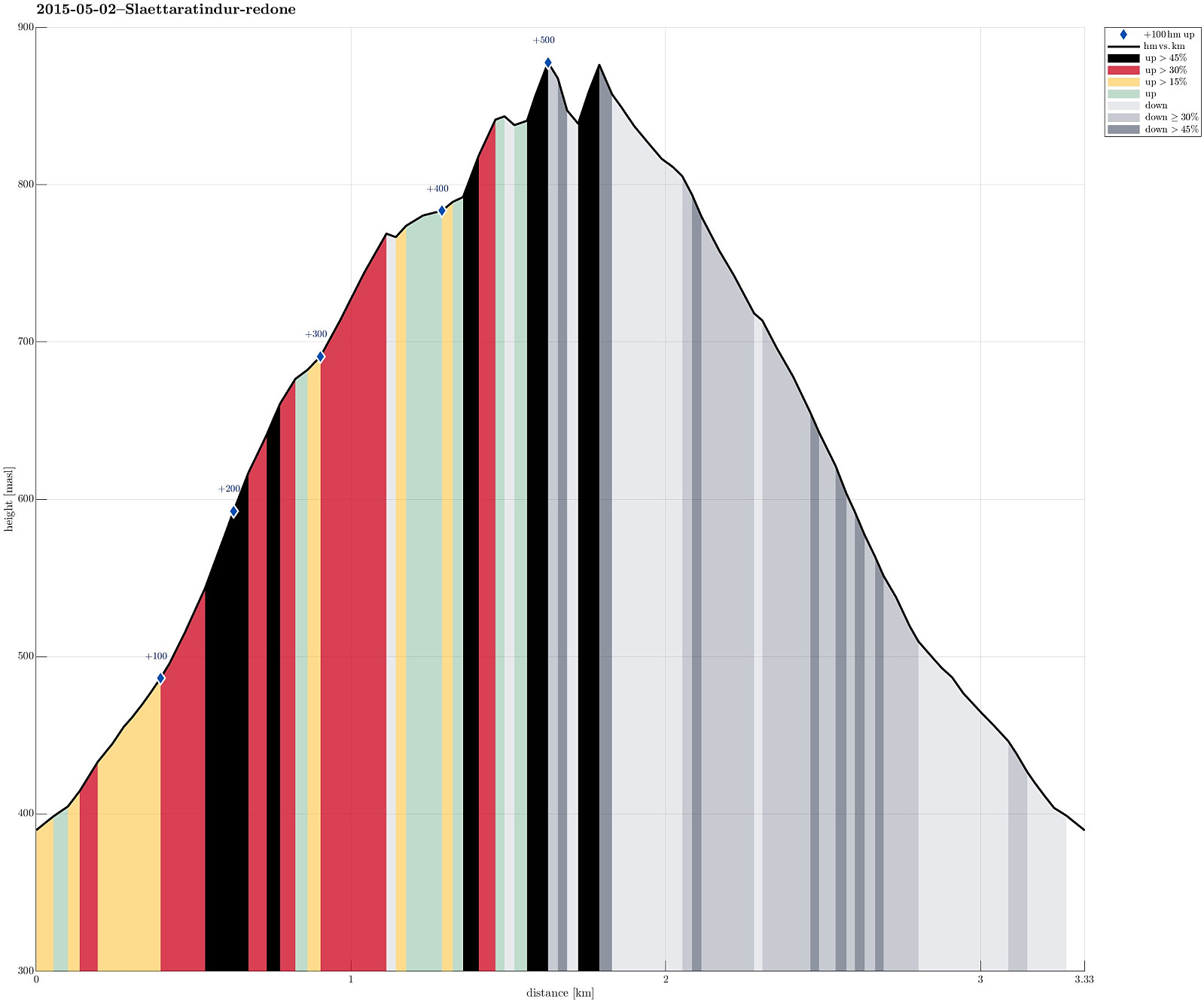 We drove up to Eiðisskarð (pass between Slættaratindur in the north and Vaðhorn in the south) and parked near the highest point on that pass (at about 380m above sealevel). From there, we basically headed straight northwards, (more or less) straight up the quite steep south-slope of Slættaratindur. Doing so, we quickly reached a high ridge, which extends eastwards from Slættaratindur. The ascend was OK (with regular hiking boots) even though it quickly became unavoidable to pass over patches of (steep) snow -- there it was necessary to walk carefully and set each foot consciously. We then followed the ridge towards Slættaratindur. We tried two or three ascends from the eastside, but the proved to be very difficult (climbing, very steep, icy and snowy, etc.) and we decided to descend >>>
Tindur
- Datum:
- 02.05.2015
- Tourcharakter:
- Bergtour
- Tourlänge:
- 3:30h
- Entfernung:
- 7,8km
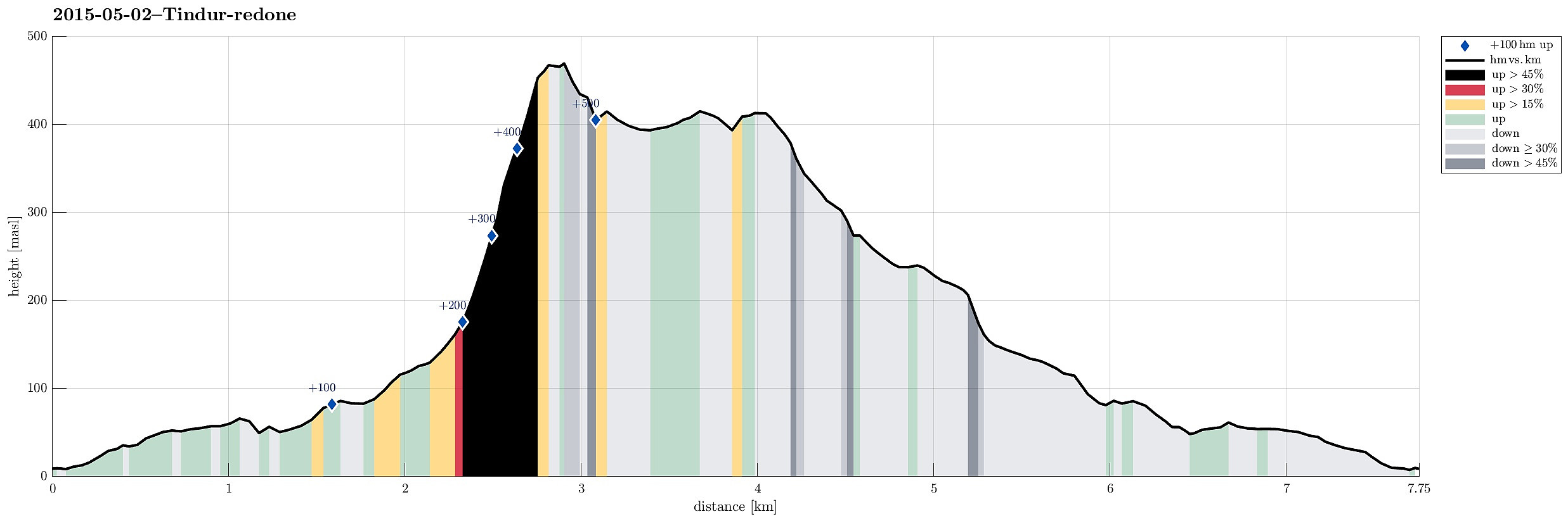 We drove to Elduvík and parked near the cemetery. From there we followed a narrow path (along the northern slope of Skoratindur), along Funningsfjørdur. Between Skoratindur and Tindur, this path leads upwards and over a (not very high!) pass, towards Fuglafjørður. From this pass (below 160m above sealevel) we ascended Tindur, first via its (very!) steep western slope. Before we could reach the top, the slope became so steep that we avoided the last bit by detouring a bit towards the southwestern ascend (which proved to be much easier). From the top one has fantastic views in all directions, wow! :-) Once on the top, we decided to continue towards the eastern-most tip of Tindur, connected by an easy to walk ridge. More wonderful views can be enjoyed from both the ridge and its end >>>
Villingadalsfjall
- Datum:
- 01.05.2015
- Tourcharakter:
- Bergtour
- Tourlänge:
- 5:00h
- Entfernung:
- 4,9km
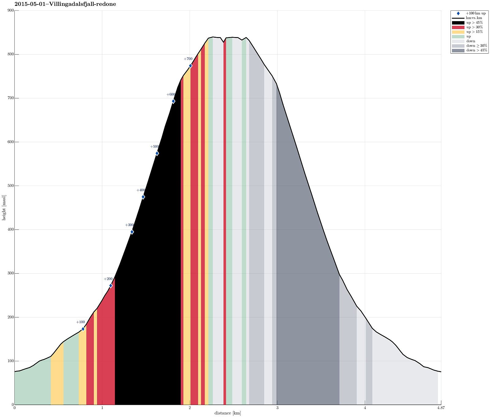 We parked in the northern end of Viðareiði (almost at the end of the upper road, near the place, where the street is a bit wider). From there we went to the end of the road, then along a small stone wall, already ascending towards Villingadalsfjall. Then, we basically followed a series of blue sticks, which someone placed in short distances from each other to indicate the best path up. Ascending to the top proved to be (very) steep in selected places and we had to concentrate -- not at the least due the snow (quite a bit of snow, still). The top itself flattens out and there are magnificent views in all directions! What a great tour! After a short break on the top (even though the weather was very good, the conditions still did not invite to stay on the top for very long), we descended >>>
