Archive - Date
Archive - Activity
-
Bike trip (137)
- Bike trip - mixed (51)
- Bike trip - road (9)
-
Other trip (1)
- Kayaking (1)
-
Other winter trip (4)
- Snowshoe trip (4)
- Ski trip (4)
- Trip by foot (740)
Archive - Geography
Peakbook-Friends


Collected lists
-
Bergen ≥ 50m pf. og ≥ 100 m.o.h.
(87/89)
 97%
97% -
Most dominating tops of the Bergen peninsula
(68/75)
90%
-
Utvalgte topper og turmål i Bergen
(316/352)
89%
-
Alle topper i Bergen
(357/400)
89%
-
Opptur Bergen
(100/113)
88%
-
De syv fjell rundt Bergen
(6/7)
85%
-
Sund ≥ 50m pf.
(14/18)
77%
-
Os ≥ 50m pf.
(25/34)
73%
-
Søyler (fastmerker) i Bergen
(68/100)
68%
-
Fjell ≥ 50m pf.
(21/32)
65%

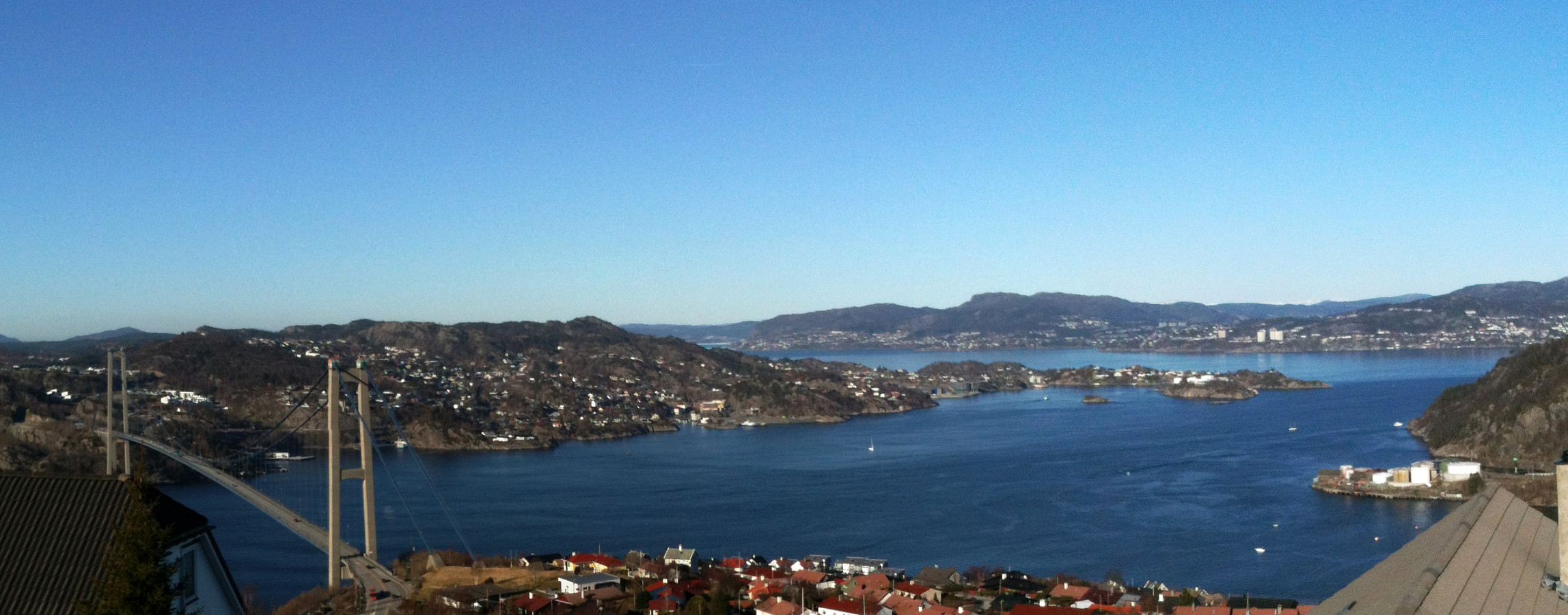
Straumefjellet
- Date:
- 29.03.2015
- Characteristic:
- Walk
- Duration:
- 1:30h
- Distance:
- 7.1km
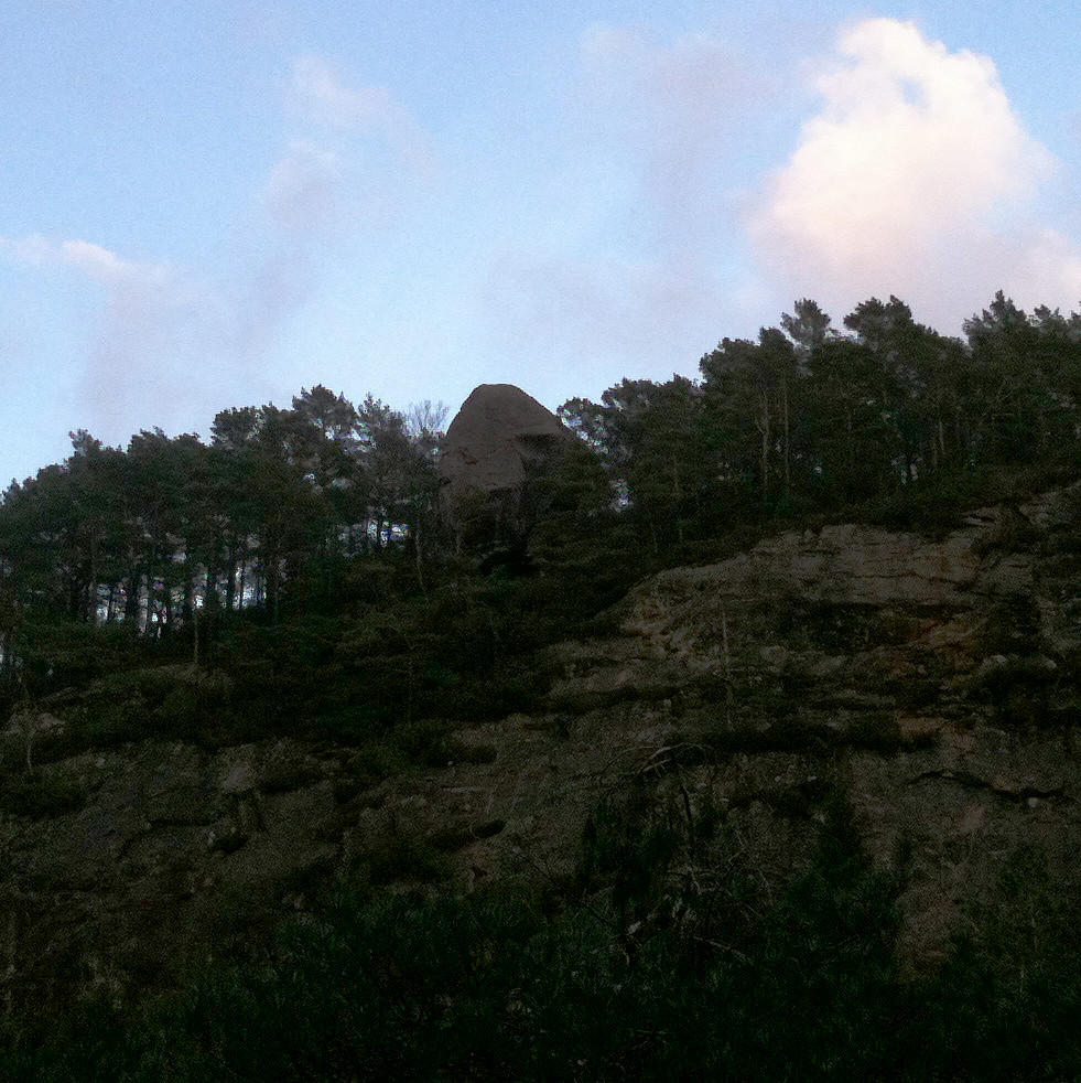
 Starting from Varden, we first followed Bjørgeveien for a short distance, then turned left into Kjerreidvika. At the seaside, right opposite to Håkonsvern with all its military ships, we started to follow the shoreline -- first on a path, then directly on the short. At the bottom of Hestabakken, we too a look at a (really) small lighthouse. The area is interesting -- one gets the impression that earlier (during WWII?) some major construction work was done here. After a bit more along the shore, we followed a steep, but easy to climb, ridge up into the direction of Kampen. Eventually, however, we ascended to Straumefjellet, instead, and then returned from there via Bjørndalsskogen. At the very end of Bjørndalssskogen, near house #172, there is a small playing ground for kids -- from >>>
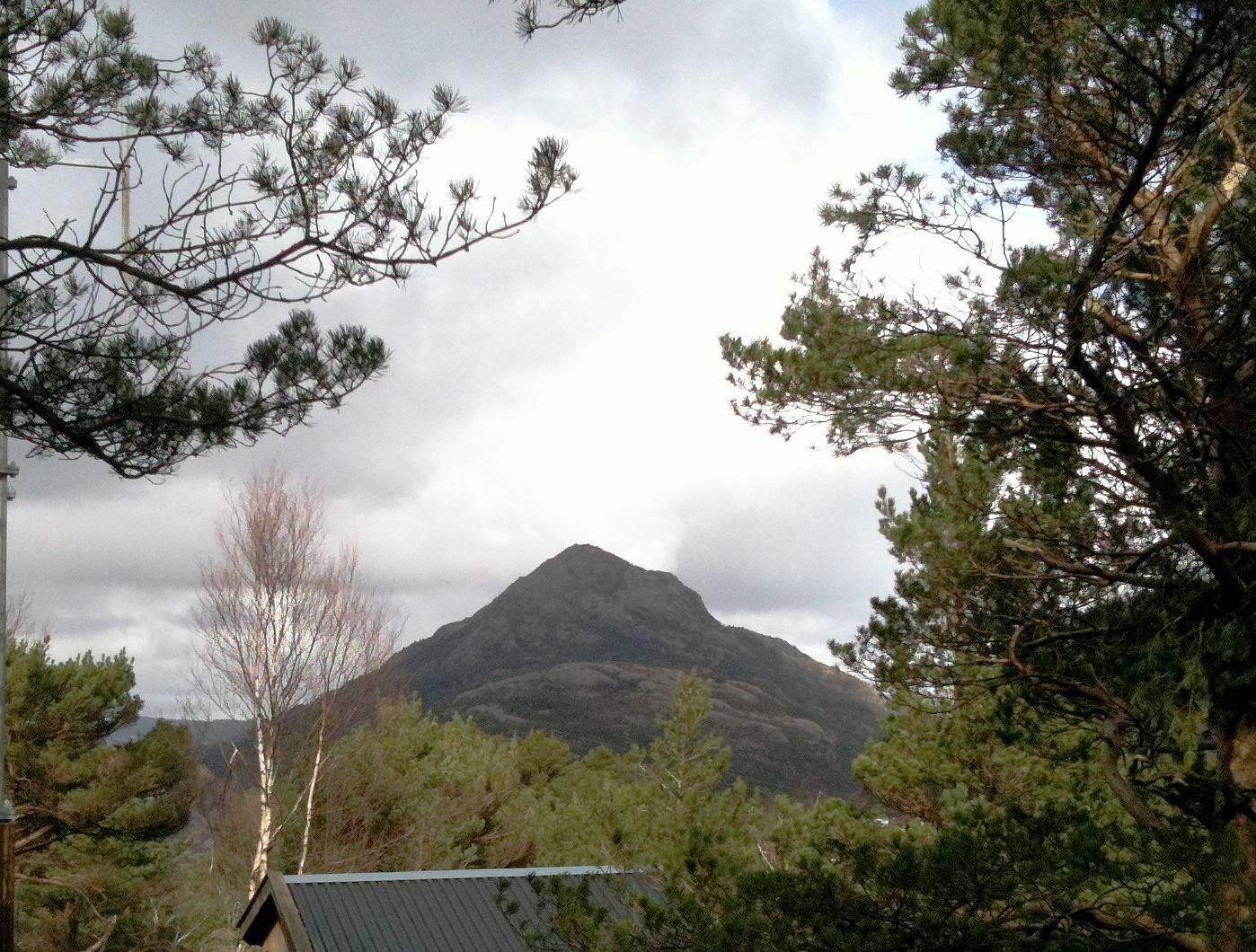
Løvstakken from/to Krohnegården
- Date:
- 28.03.2015
- Characteristic:
- Hillwalk
- Duration:
- 1:00h
- Distance:
- 3.2km
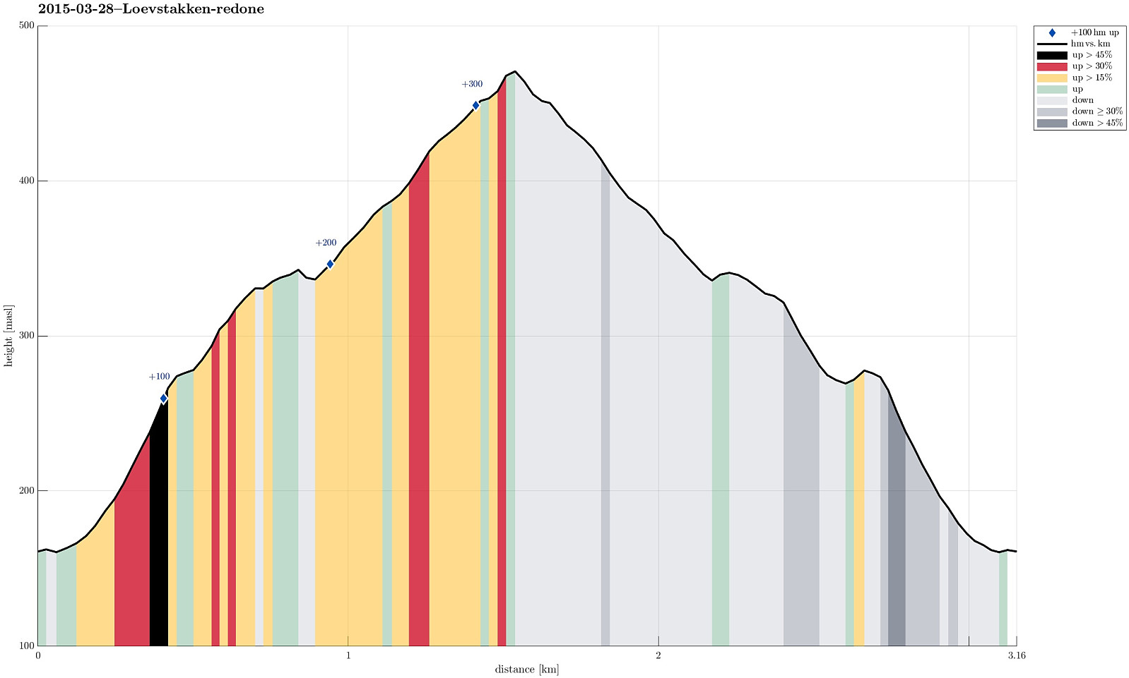 Simple, quick, and refreshing short hike up and down Løvstakken (from Krohnegården)
Web page WestCoastPeaks.com provides useful information about Løvstakken .
Simple, quick, and refreshing short hike up and down Løvstakken (from Krohnegården)
Web page WestCoastPeaks.com provides useful information about Løvstakken .
Grøntua
- Date:
- 15.03.2015
- Characteristic:
- Walk
- Duration:
- 1:00h
- Distance:
- 5.0km
 Starting from Brønndalen, we quickly ascended to Grøntua -- a small top west of Lyderhorn with a nice view! :-) From there, via Olskvikåsen, a school, and Olsvik (another school), we first descended to Olsvikstallen, from where we ascended to Festeråsen, where still ruins from WWII are visible. From there we went back, once again passing over Grøntua. All in all, a very relaxed Sunday afternoon walk (in great spring weather).
Petter Bjørstad has a useful page about Grøntua .
Starting from Brønndalen, we quickly ascended to Grøntua -- a small top west of Lyderhorn with a nice view! :-) From there, via Olskvikåsen, a school, and Olsvik (another school), we first descended to Olsvikstallen, from where we ascended to Festeråsen, where still ruins from WWII are visible. From there we went back, once again passing over Grøntua. All in all, a very relaxed Sunday afternoon walk (in great spring weather).
Petter Bjørstad has a useful page about Grøntua .
Storsåta from Eidsvåg
- Date:
- 14.03.2015
- Characteristic:
- Hillwalk
- Duration:
- 3:30h
- Distance:
- 11.1km
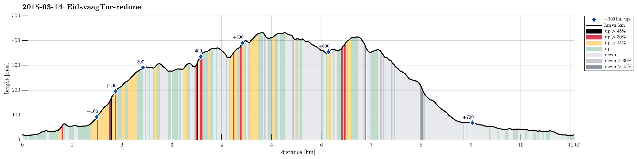 Starting from Eidsvåg, we first followed the old postal path (den trondhjemske postvei), before we turned to the right (at Glasskaret), ascending to Slettafjellet. After having visited Fosshøyen, we crossed over to Litlanipa. From there, it only is a few step, before one ascends to Nukane, passing by Stornipa. Passing over Nukane, we got down into Ullskargjelet, before ascending, again -- this time to Storsåta (the highest top on this hike). Continuing, we passed over Gråbeinryggen and Grønabrekkene, looking down to Setervatnet to our right. At Stangelifjellet, we left the main path and descended over a nice ridge, which separates Setervatnet from Vinddalen, first down to the dam of Setervatnet, before then descending through Kløvet to Vinddalsveien. Then, we simply walked down >>>
Kanadaskogen
- Date:
- 08.03.2015
- Characteristic:
- Walk
- Duration:
- 2:00h
- Distance:
- 8.7km
 Quick round in Kanadaskogen -- good to get out and refresh the mind! :-)
