Archive - Date
Archive - Activity
-
Bike trip (137)
- Bike trip - mixed (51)
- Bike trip - road (9)
-
Other trip (1)
- Kayaking (1)
-
Other winter trip (4)
- Snowshoe trip (4)
- Ski trip (4)
- Trip by foot (740)
Archive - Geography
Peakbook-Friends


Collected lists
-
Bergen ≥ 50m pf. og ≥ 100 m.o.h.
(87/89)
 97%
97% -
Most dominating tops of the Bergen peninsula
(68/75)
90%
-
Utvalgte topper og turmål i Bergen
(316/350)
90%
-
Alle topper i Bergen
(357/398)
89%
-
Opptur Bergen
(100/113)
88%
-
De syv fjell rundt Bergen
(6/7)
85%
-
Sund ≥ 50m pf.
(14/18)
77%
-
Os ≥ 50m pf.
(25/34)
73%
-
Søyler (fastmerker) i Bergen
(68/100)
68%
-
Fjell ≥ 50m pf.
(21/32)
65%

Brekkjedalen
- Date:
- 25.01.2015
- Characteristic:
- Walk
- Duration:
- 1:30h
- Distance:
- 7.1km
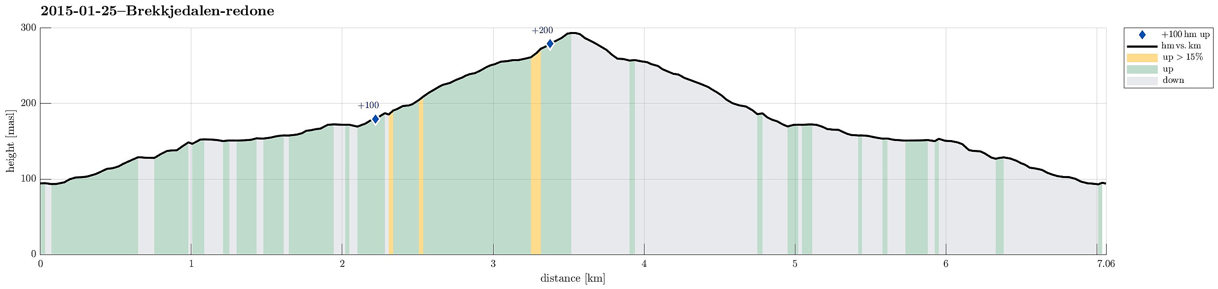 Starting from the end of Hausdalen, we walked along the gravel road into Brekkjedalen. First, this really was an easy walk until the snow got deeper and deeper. In the end, every step was demanding, even though we "only" followed the road. Anyway: A nice and rewarding winter trip in a beautiful valley! :-)
Løvstakken
- Date:
- 18.01.2015
- Characteristic:
- Hillwalk
- Duration:
- 2:00h
- Distance:
- 5.6km
 Starting from Nils Langhelles vei (its lowest point), we first ascended
primarily eastwards, up to a point on the ridge between Gullsteinen and Løvstakken (relatively near to Gullsteinen, actually). Then, we followed the ridge up to Løvstakken and descended on the other side, taking the possible turns to the left, in order to get down, to Krohnegården, again. From there, it then was only a short walk on the street, back to Nils Langhelles vei. A nice 2h winter hike! :-)
Web page WestCoastPeaks.com provides useful information about Løvstakken .
Starting from Nils Langhelles vei (its lowest point), we first ascended
primarily eastwards, up to a point on the ridge between Gullsteinen and Løvstakken (relatively near to Gullsteinen, actually). Then, we followed the ridge up to Løvstakken and descended on the other side, taking the possible turns to the left, in order to get down, to Krohnegården, again. From there, it then was only a short walk on the street, back to Nils Langhelles vei. A nice 2h winter hike! :-)
Web page WestCoastPeaks.com provides useful information about Løvstakken .
Løvstakken
- Date:
- 11.01.2015
- Characteristic:
- Hillwalk
- Duration:
- 1:30h
- Distance:
- 3.7km
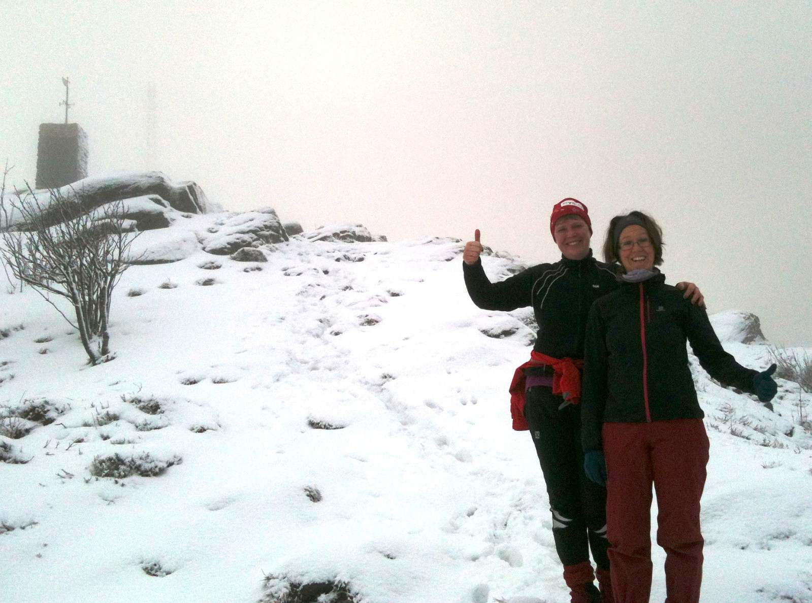
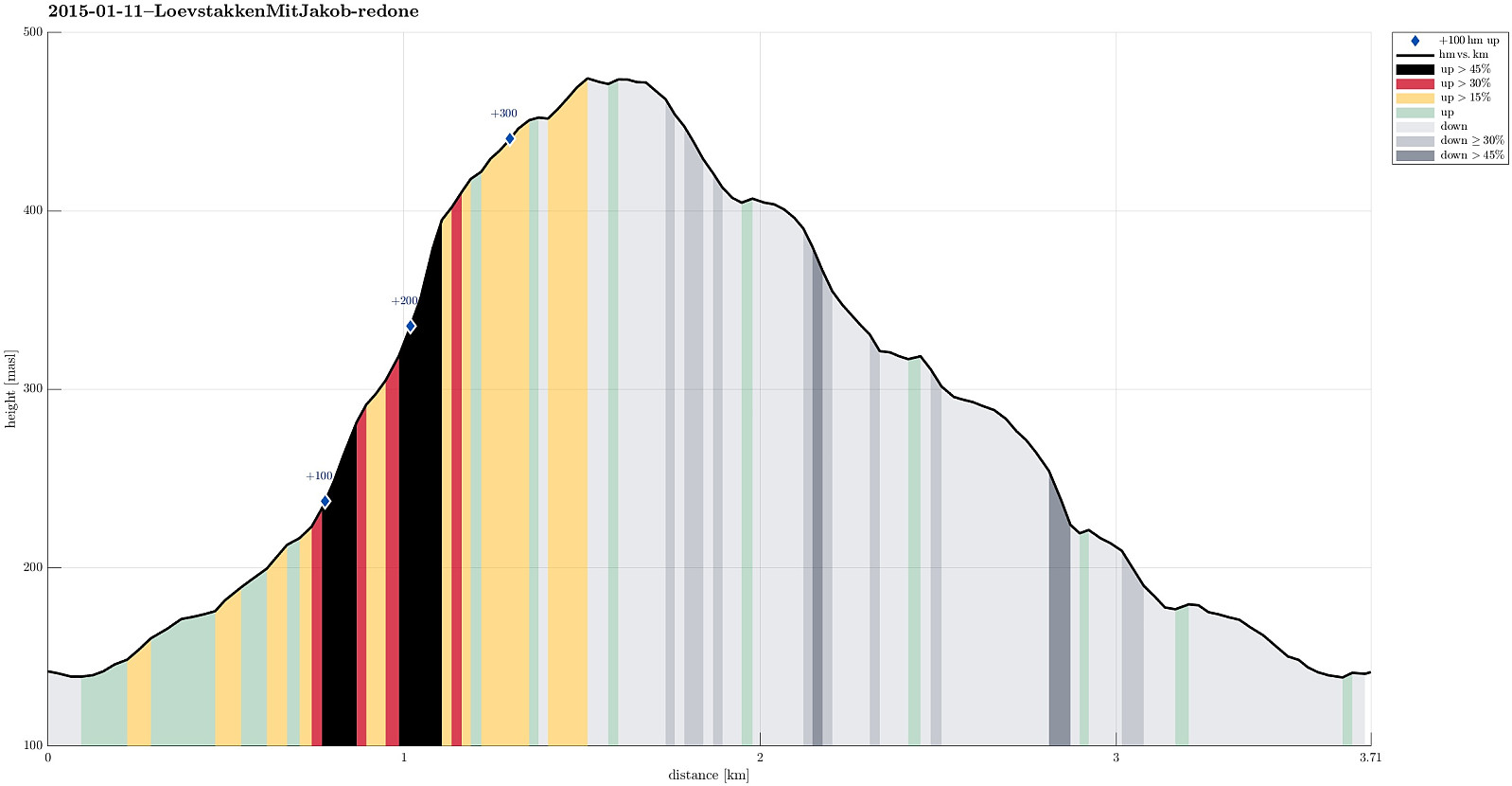 Starting from Krohnegården, we ascended under the (due to storm Nina partially damaged!) cable line up to Løvstakken (the maybe steepest ascend to Løvstakken?!), where we faced cold and icy winds from the north, northwest. This made us return via Strutsefarmen, i.e., first southwards towards Gullstølen, but then westwards and downwards, back to Krohnegården. A quick and nice Sunday hike! :-)
Web page WestCoastPeaks.com provides useful information about Løvstakken .
Starting from Krohnegården, we ascended under the (due to storm Nina partially damaged!) cable line up to Løvstakken (the maybe steepest ascend to Løvstakken?!), where we faced cold and icy winds from the north, northwest. This made us return via Strutsefarmen, i.e., first southwards towards Gullstølen, but then westwards and downwards, back to Krohnegården. A quick and nice Sunday hike! :-)
Web page WestCoastPeaks.com provides useful information about Løvstakken .
