Archive - Date
Archive - Activity
-
Bike trip (137)
- Bike trip - mixed (51)
- Bike trip - road (9)
-
Other trip (1)
- Kayaking (1)
-
Other winter trip (4)
- Snowshoe trip (4)
- Ski trip (4)
- Trip by foot (740)
Archive - Geography
Peakbook-Friends


Collected lists
-
Bergen ≥ 50m pf. og ≥ 100 m.o.h.
(87/89)
 97%
97% -
Most dominating tops of the Bergen peninsula
(68/75)
90%
-
Utvalgte topper og turmål i Bergen
(316/352)
89%
-
Alle topper i Bergen
(357/400)
89%
-
Opptur Bergen
(100/113)
88%
-
De syv fjell rundt Bergen
(6/7)
85%
-
Sund ≥ 50m pf.
(14/18)
77%
-
Os ≥ 50m pf.
(25/34)
73%
-
Søyler (fastmerker) i Bergen
(68/100)
68%
-
Fjell ≥ 50m pf.
(21/32)
65%

Vidden from Langedalen
- Date:
- 21.09.2014
- Characteristic:
- Hillwalk
- Duration:
- 3:30h
- Distance:
- 10.9km
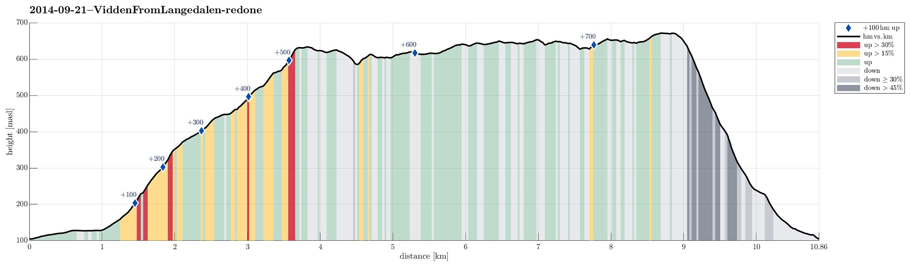 Starting in Langedalen (between Espeland and Rødland), we first followed the road northwards to Borgo, where we left the road to go up to Borgaskaret. We happened to end up on the path up Kvitnosa, which we followed until we reached Borgavatnet. From there, we connected upwards to Vardegga. Going "back" on Vidden, via Borgaskaret and via Storfjellet, we did not really find the shortest path towards Hauggjelsvarden, but went first to Turnerhytten, from where we turned (again) back towards Hauggjelsvarden (via Byfjellenes høyeste punkt). From Hauggjelsvarden, we descended (without a path) to Langedalen (not really a recommended way of getting back).
Web page WestCoastPeaks.com provides useful information about Haugavarden, Ulriken, Storfjellet, and Landåsfjellet
and also Petter Bjørstad has a useful page about Ulriken .
Starting in Langedalen (between Espeland and Rødland), we first followed the road northwards to Borgo, where we left the road to go up to Borgaskaret. We happened to end up on the path up Kvitnosa, which we followed until we reached Borgavatnet. From there, we connected upwards to Vardegga. Going "back" on Vidden, via Borgaskaret and via Storfjellet, we did not really find the shortest path towards Hauggjelsvarden, but went first to Turnerhytten, from where we turned (again) back towards Hauggjelsvarden (via Byfjellenes høyeste punkt). From Hauggjelsvarden, we descended (without a path) to Langedalen (not really a recommended way of getting back).
Web page WestCoastPeaks.com provides useful information about Haugavarden, Ulriken, Storfjellet, and Landåsfjellet
and also Petter Bjørstad has a useful page about Ulriken .
Vardafjellet/Orretuva
- Date:
- 14.09.2014
- Characteristic:
- Hillwalk
- Duration:
- 2:30h
- Distance:
- 8.7km
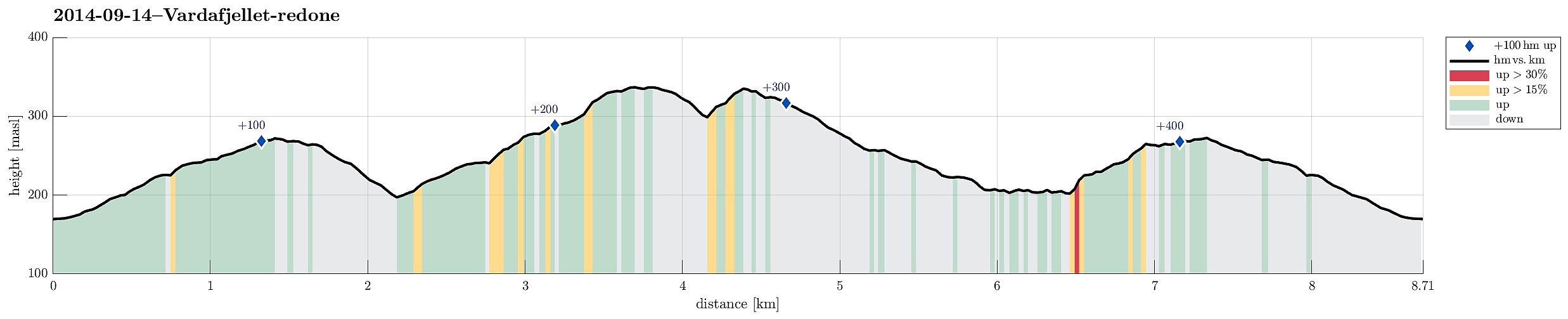 Quick Sunday afternoon round, including Vardafjellet and Orretuva, starting from Fjellbirkeland, following first a gravel road towards south-east into Tjørnadalen, before turning back upwards (to the north-east) towards Vardafjellet first, then Orretuva. Afterwards, down to Stignavatnet and along it, before back up to the gravel road. All in all, the hike was moderately boring with only short parts (for ex., along Stignavatnet) through quite romantic nature.
Web page WestCoastPeaks.com provides useful information about Orretuva and Vardafjellet
and also Petter Bjørstad has a useful page about Vardafjellet (Orretuva) .
Quick Sunday afternoon round, including Vardafjellet and Orretuva, starting from Fjellbirkeland, following first a gravel road towards south-east into Tjørnadalen, before turning back upwards (to the north-east) towards Vardafjellet first, then Orretuva. Afterwards, down to Stignavatnet and along it, before back up to the gravel road. All in all, the hike was moderately boring with only short parts (for ex., along Stignavatnet) through quite romantic nature.
Web page WestCoastPeaks.com provides useful information about Orretuva and Vardafjellet
and also Petter Bjørstad has a useful page about Vardafjellet (Orretuva) .
Torneberget
- Date:
- 13.09.2014
- Characteristic:
- Hillwalk
- Duration:
- 1:30h
- Distance:
- 4.4km
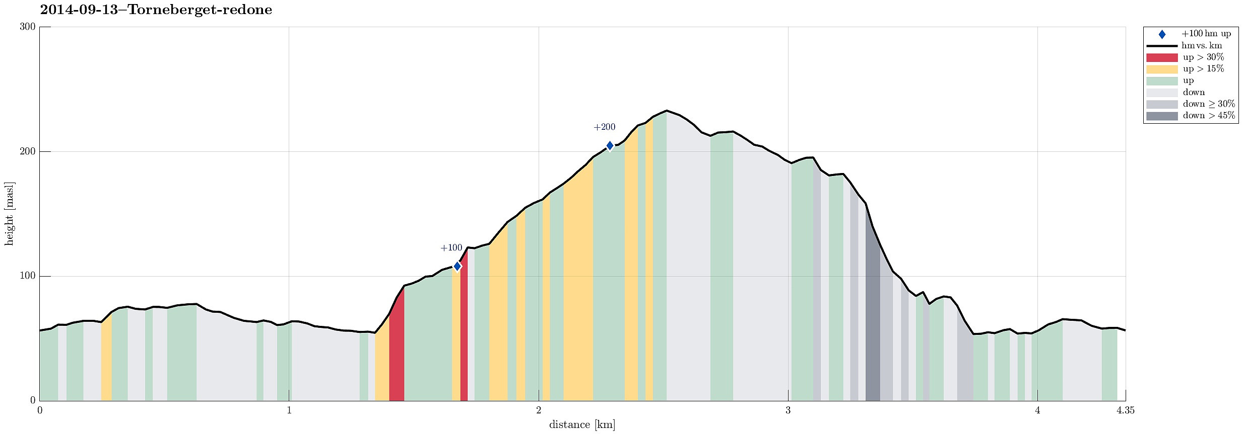 While my son played some soccer at Slåtthaug, I made a quick ascent to nearby Torneberget -- it's a not-at-all-prominent peak in front of Smøråsfjellet, towards Bergen, with selected views northwards over Bergen. Descending towards Slåtthaug, without any path through the woods, was a little bit challenging, because descending finally towards the houses of Smøråsflaten proved to be very steep (just a few meters, bust still).
Solbakkafjellet
- Date:
- 07.09.2014
- Characteristic:
- Hillwalk
- Duration:
- 4:00h
- Distance:
- 12.2km
 Easy afternoon hike with some nice views! Starting from Bjøllehaugane, first in direction south-east, before entering the ridge up to Solbakkafjellet, it's easy to find (if you take the right turns -- a few paths lead other ways!). On the top, which is stretched out quite a bit, a few nice views over Bergen and nearby mountains (Sveningen, Hausdalshorgi, Sydpolen, etc.) are possible. Down, we first continued towards Frotveitvatnet, before turning left and back (in parallel, south-east to the "main road" into Bontveit). The last stretch -- from Lonsmoget to Almeland -- we made through a pretty magical forest! :-)
Web page WestCoastPeaks.com provides useful information about Solbakkafjellet
and also Petter Bjørstad has a useful page about Solbakkafjellet .
Easy afternoon hike with some nice views! Starting from Bjøllehaugane, first in direction south-east, before entering the ridge up to Solbakkafjellet, it's easy to find (if you take the right turns -- a few paths lead other ways!). On the top, which is stretched out quite a bit, a few nice views over Bergen and nearby mountains (Sveningen, Hausdalshorgi, Sydpolen, etc.) are possible. Down, we first continued towards Frotveitvatnet, before turning left and back (in parallel, south-east to the "main road" into Bontveit). The last stretch -- from Lonsmoget to Almeland -- we made through a pretty magical forest! :-)
Web page WestCoastPeaks.com provides useful information about Solbakkafjellet
and also Petter Bjørstad has a useful page about Solbakkafjellet .
