Archiv - Nach Datum
Archiv - Nach Aktivität
-
Andere Tour (1)
- Kayaking (1)
-
Andere Wintertour (4)
- Schneeschuhtour (4)
-
Fahrradtour (137)
- Fahrradtour Straße (9)
- Fahrradtour gemischt (51)
-
Fußtour (740)
- Bergtour (363)
- Jogging (18)
- Spaziergang (89)
- Wanderung (270)
-
Skitour (4)
- Tourenskilauf (4)
Archiv - Nach Geografie
Peakbookfreunde


Gesammelte Listen
-
Bergen ≥ 50m pf. og ≥ 100 m.o.h.
(87/89)
 97%
97% -
Most dominating tops of the Bergen peninsula
(68/75)
90%
-
Utvalgte topper og turmål i Bergen
(316/350)
90%
-
Alle topper i Bergen
(357/398)
89%
-
Opptur Bergen
(100/113)
88%
-
De syv fjell rundt Bergen
(6/7)
85%
-
Sund ≥ 50m pf.
(14/18)
77%
-
Os ≥ 50m pf.
(25/34)
73%
-
Søyler (fastmerker) i Bergen
(68/100)
68%
-
Fjell ≥ 50m pf.
(21/32)
65%

Raudlifjellet
- Datum:
- 16.08.2014
- Tourcharakter:
- Bergtour
- Tourlänge:
- 3:00h
- Entfernung:
- 8,8km
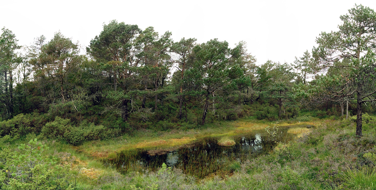 Nice small tour up Raudlifjellet (via Nordhordlandskulten) from Tømmernes -- the path is not easy to find at once, but once one has found it (also not difficult), it's nice and easy to the top(s). Some nice views towards Kalandsvatnet and towards Os.
Web page WestCoastPeaks.com provides useful information about Raudlifjellet
and also Petter Bjørstad has a useful page about Raudlifjellet (Sælefjellet) .
Nice small tour up Raudlifjellet (via Nordhordlandskulten) from Tømmernes -- the path is not easy to find at once, but once one has found it (also not difficult), it's nice and easy to the top(s). Some nice views towards Kalandsvatnet and towards Os.
Web page WestCoastPeaks.com provides useful information about Raudlifjellet
and also Petter Bjørstad has a useful page about Raudlifjellet (Sælefjellet) .
Traunstein
- Datum:
- 08.08.2014
- Tourcharakter:
- Bergtour
- Tourlänge:
- 6:00h
- Entfernung:
- 14,5km
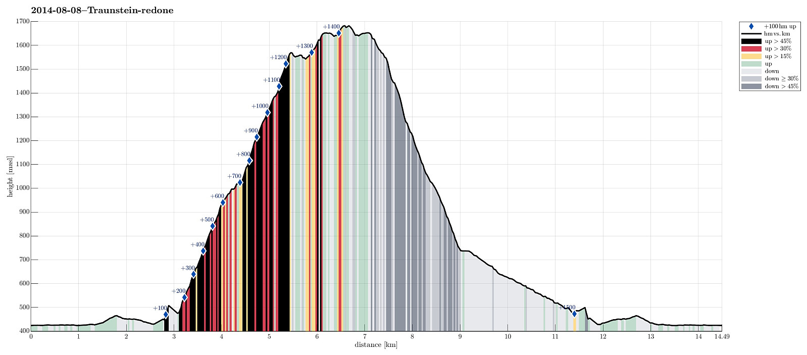 Starting from Traunsee (~450m, southeast from Gmunden), up the Naturfreundesteig (climbing trail, category A/B), we first reached Traunsteinhaus (1575m, still quite new after a recent upgrading). It took a bit more than 2 hours, but easily this could be more, depending on the climbing conditions -- it's more than 1000m up a substantially steep climbing path! Then, we connected to Gmundner Hütte (1660m), another impressive house on top of this prominent mountain! The actual top, Traunstein (1691m) is then quite near and easy to reach. Down we took the trail towards Mair Alm, which is very steep, but good to go. All in all, including an extended break on Gmundner Hütte, this was about 6+ hours of hiking. Very rewarding!
Selected photos are available as Google photo album .
Starting from Traunsee (~450m, southeast from Gmunden), up the Naturfreundesteig (climbing trail, category A/B), we first reached Traunsteinhaus (1575m, still quite new after a recent upgrading). It took a bit more than 2 hours, but easily this could be more, depending on the climbing conditions -- it's more than 1000m up a substantially steep climbing path! Then, we connected to Gmundner Hütte (1660m), another impressive house on top of this prominent mountain! The actual top, Traunstein (1691m) is then quite near and easy to reach. Down we took the trail towards Mair Alm, which is very steep, but good to go. All in all, including an extended break on Gmundner Hütte, this was about 6+ hours of hiking. Very rewarding!
Selected photos are available as Google photo album .
Katrin
- Datum:
- 07.08.2014
- Tourcharakter:
- Bergtour
- Tourlänge:
- 3:00h
- Entfernung:
- 6,6km
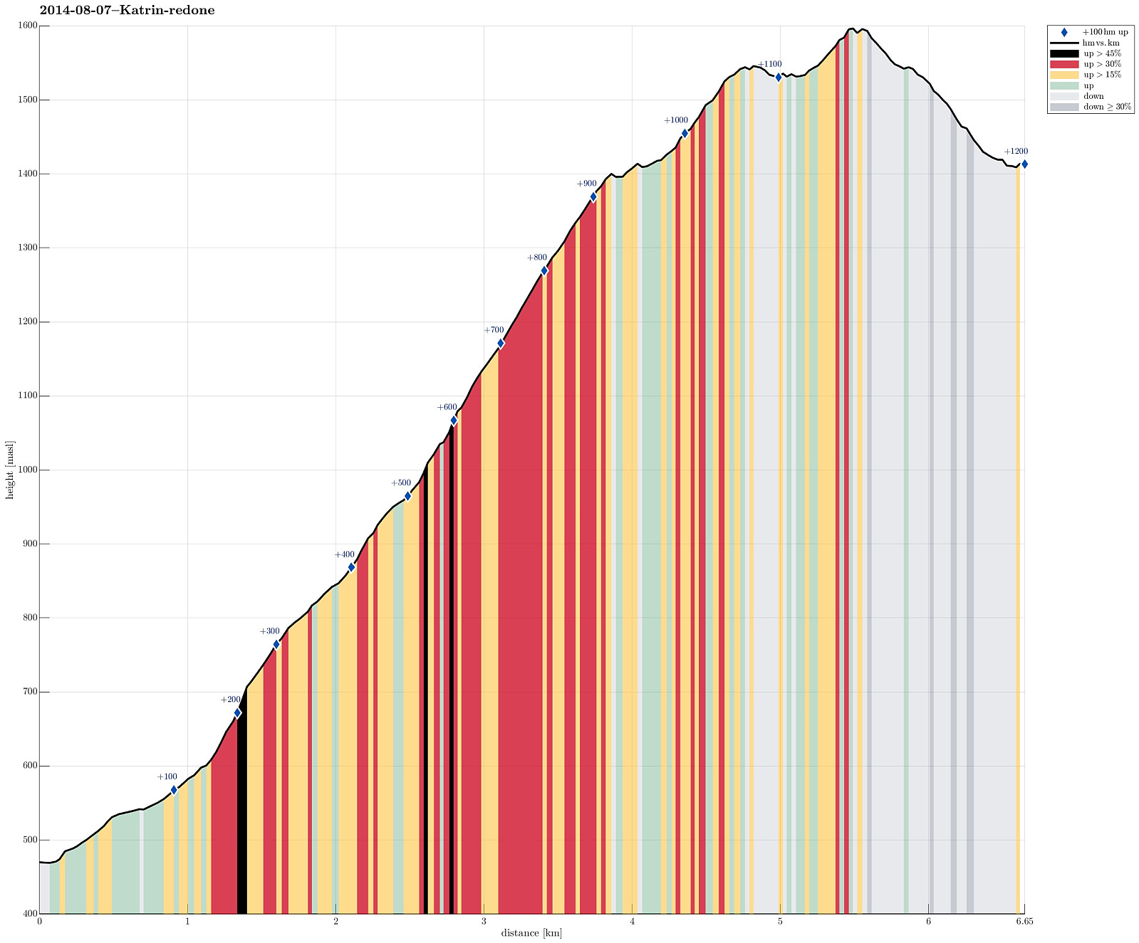 Up from Bad Ischl (where the cable car starts, at 470m, via Bildweg) to Katrinalm (1413m), which is a nice, steep hike up (about 1000m up) and then -- after some nice rest with served food and drinks -- quickly up to Katrin-Kreuz (1542m) and Elferkogel (1601m). Down, then, very comfortably with the cable car. :-)
Hochleckenhaus (Höllengebirge)
- Datum:
- 06.08.2014
- Tourcharakter:
- Bergtour
- Tourlänge:
- 4:00h
- Entfernung:
- 12,1km
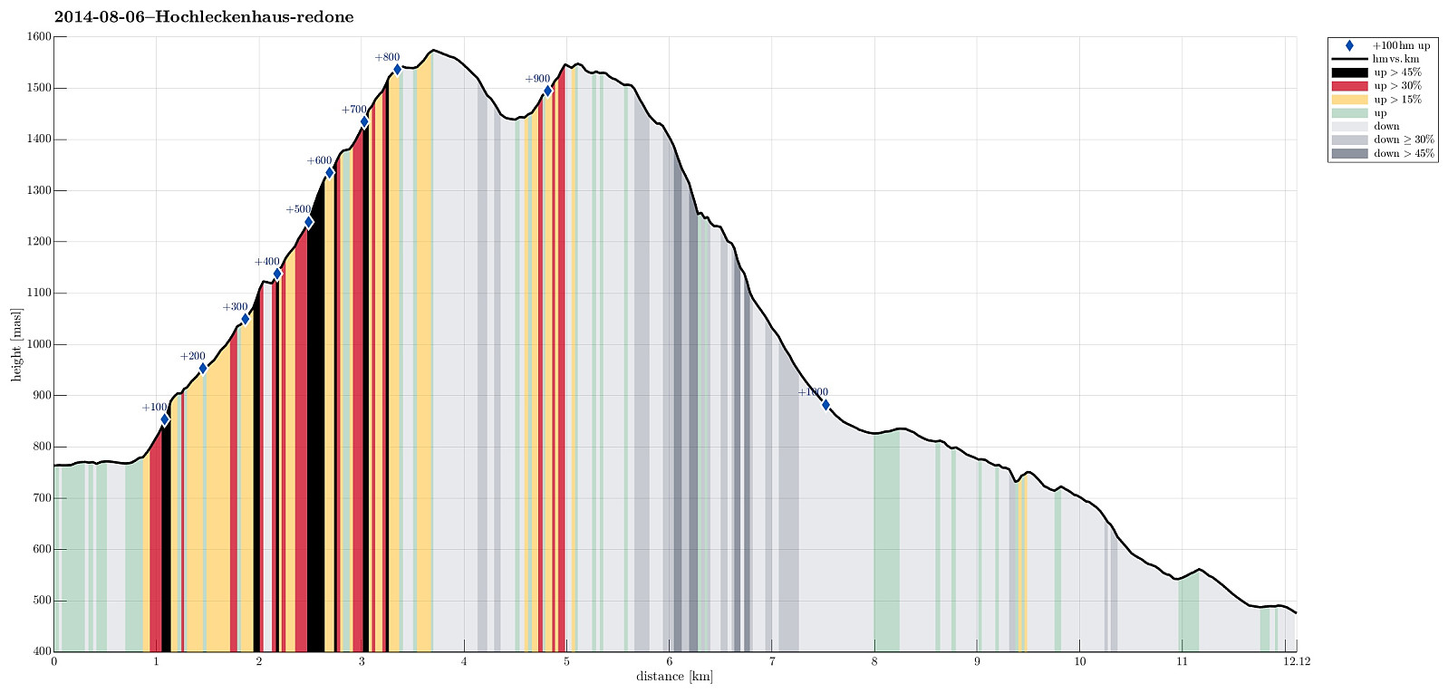 Starting from Taferlklaussee (763m), we first ascended to Hochleckenhaus (1574m) via a well-marked path (note: the start is somehow unclear -- mostly due to many other small trails near and around Taferlklausssee). After a nice and refreshing rest at Hochleckenhaus -- yes, with served food and drinks! :-) -- we descended towards Steinbach am Attersee (via Geissalm and Stieg -- the 2nd option for hiking to Steinbach), which offers terrific views -- not at the least to Attersee! The path down from Höllengebirge is (partially) steep and it's hundreds of meters straight down next to the path in selected places (you better are not afraid of heights there). All in all, a great hike! :-)
Selected photos are available as a Google photo album .
Starting from Taferlklaussee (763m), we first ascended to Hochleckenhaus (1574m) via a well-marked path (note: the start is somehow unclear -- mostly due to many other small trails near and around Taferlklausssee). After a nice and refreshing rest at Hochleckenhaus -- yes, with served food and drinks! :-) -- we descended towards Steinbach am Attersee (via Geissalm and Stieg -- the 2nd option for hiking to Steinbach), which offers terrific views -- not at the least to Attersee! The path down from Höllengebirge is (partially) steep and it's hundreds of meters straight down next to the path in selected places (you better are not afraid of heights there). All in all, a great hike! :-)
Selected photos are available as a Google photo album .
