Archiv - Nach Datum
Archiv - Nach Aktivität
-
Andere Tour (1)
- Kayaking (1)
-
Andere Wintertour (4)
- Schneeschuhtour (4)
-
Fahrradtour (137)
- Fahrradtour Straße (9)
- Fahrradtour gemischt (51)
-
Fußtour (740)
- Bergtour (363)
- Jogging (18)
- Spaziergang (89)
- Wanderung (270)
-
Skitour (4)
- Tourenskilauf (4)
Archiv - Nach Geografie
Peakbookfreunde


Gesammelte Listen
-
Bergen ≥ 50m pf. og ≥ 100 m.o.h.
(87/89)
 97%
97% -
Most dominating tops of the Bergen peninsula
(68/75)
90%
-
Utvalgte topper og turmål i Bergen
(316/352)
89%
-
Alle topper i Bergen
(357/400)
89%
-
Opptur Bergen
(100/113)
88%
-
De syv fjell rundt Bergen
(6/7)
85%
-
Sund ≥ 50m pf.
(14/18)
77%
-
Os ≥ 50m pf.
(25/34)
73%
-
Søyler (fastmerker) i Bergen
(68/100)
68%
-
Fjell ≥ 50m pf.
(21/32)
65%

Sveningen
- Datum:
- 27.04.2014
- Tourcharakter:
- Bergtour
- Tourlänge:
- 3:00h
- Entfernung:
- 13,1km
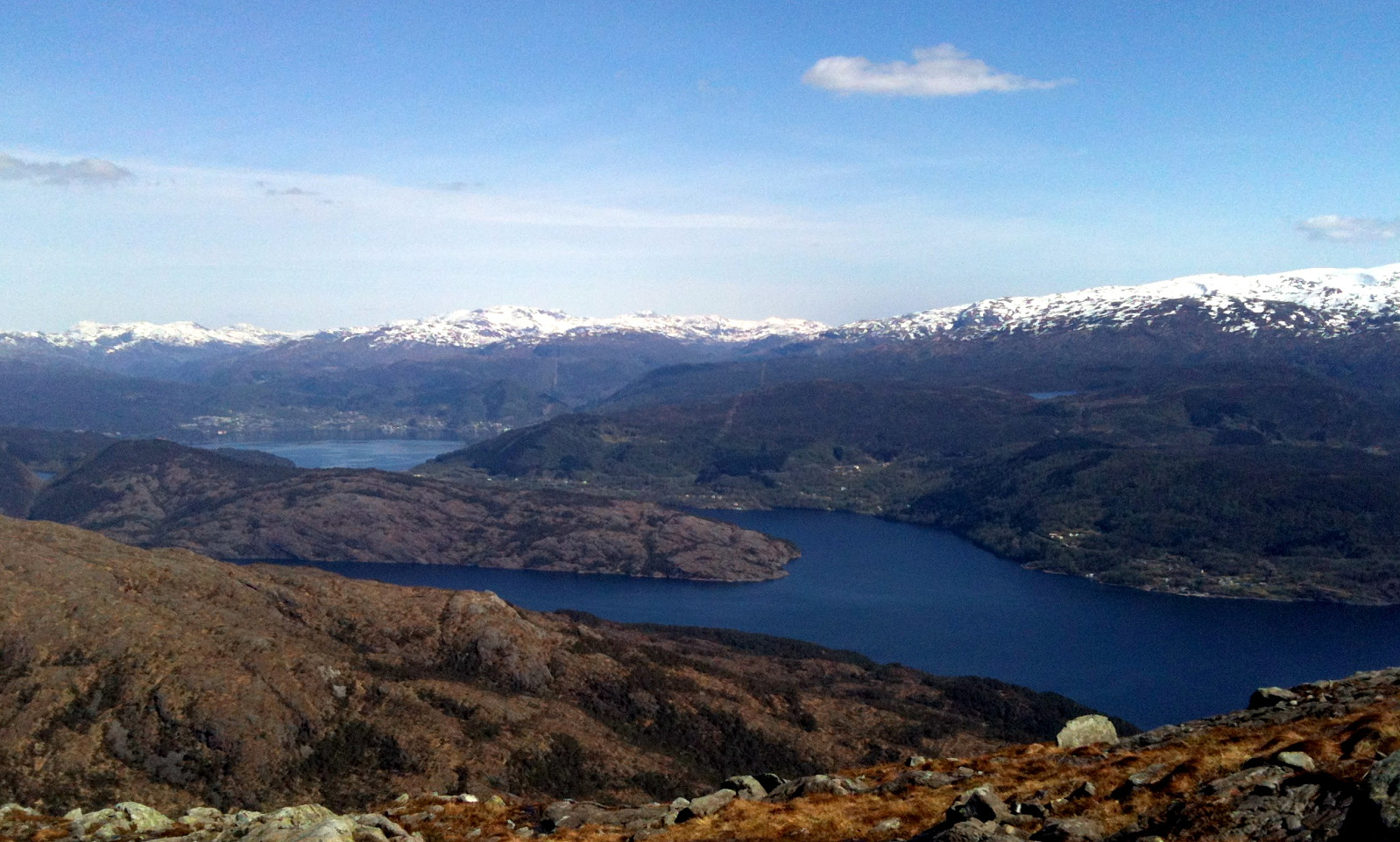 This time, we took a new route to the top: from Brekkjedalen -- that's actually very attractive and rewarding!
Web page WestCoastPeaks.com provides useful information about Sveningen, Søtefjellet, Sauskolten, Rindafjellet, and Midtsæterfjellet
and also Petter Bjørstad has a useful page about Sveningen .
This time, we took a new route to the top: from Brekkjedalen -- that's actually very attractive and rewarding!
Web page WestCoastPeaks.com provides useful information about Sveningen, Søtefjellet, Sauskolten, Rindafjellet, and Midtsæterfjellet
and also Petter Bjørstad has a useful page about Sveningen .
Løvstakken
- Datum:
- 20.04.2014
- Tourcharakter:
- Bergtour
- Tourlänge:
- 3:00h
- Entfernung:
- 11,5km
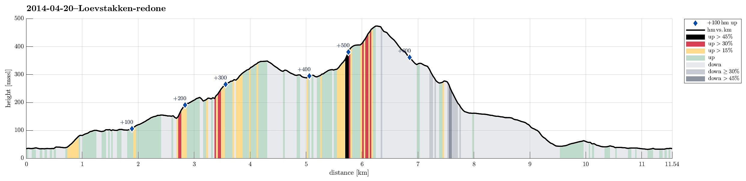 This time we made Løvstakken from Bønes via Gullsteinen -- also a very nice choice! :-)
Web page WestCoastPeaks.com provides useful information about Løvstakken .
Web page UT.no from the Norwegian Trekking Association recommends this hike (part of it), too.
This time we made Løvstakken from Bønes via Gullsteinen -- also a very nice choice! :-)
Web page WestCoastPeaks.com provides useful information about Løvstakken .
Web page UT.no from the Norwegian Trekking Association recommends this hike (part of it), too.
Bildøybakken
- Datum:
- 18.04.2014
- Tourcharakter:
- Wanderung
- Tourlänge:
- 3:00h
- Entfernung:
- 7,6km
 Nice and easy tour -- not much up, actually, but great views over the North Sea! One could also connect further to Pyttane and/or Liatårnet -- really a great hiking area! Note that parts of this tour (between km 3.6 and km 4.5) were without path, while still easy to go.
Web page WestCoastPeaks.com provides useful information about Liatårnet
and also Petter Bjørstad has a useful page about Liatårnet .
Nice and easy tour -- not much up, actually, but great views over the North Sea! One could also connect further to Pyttane and/or Liatårnet -- really a great hiking area! Note that parts of this tour (between km 3.6 and km 4.5) were without path, while still easy to go.
Web page WestCoastPeaks.com provides useful information about Liatårnet
and also Petter Bjørstad has a useful page about Liatårnet .
Lyderhorn
- Datum:
- 16.04.2014
- Tourcharakter:
- Bergtour
- Tourlänge:
- 3:00h
- Entfernung:
- 5,2km
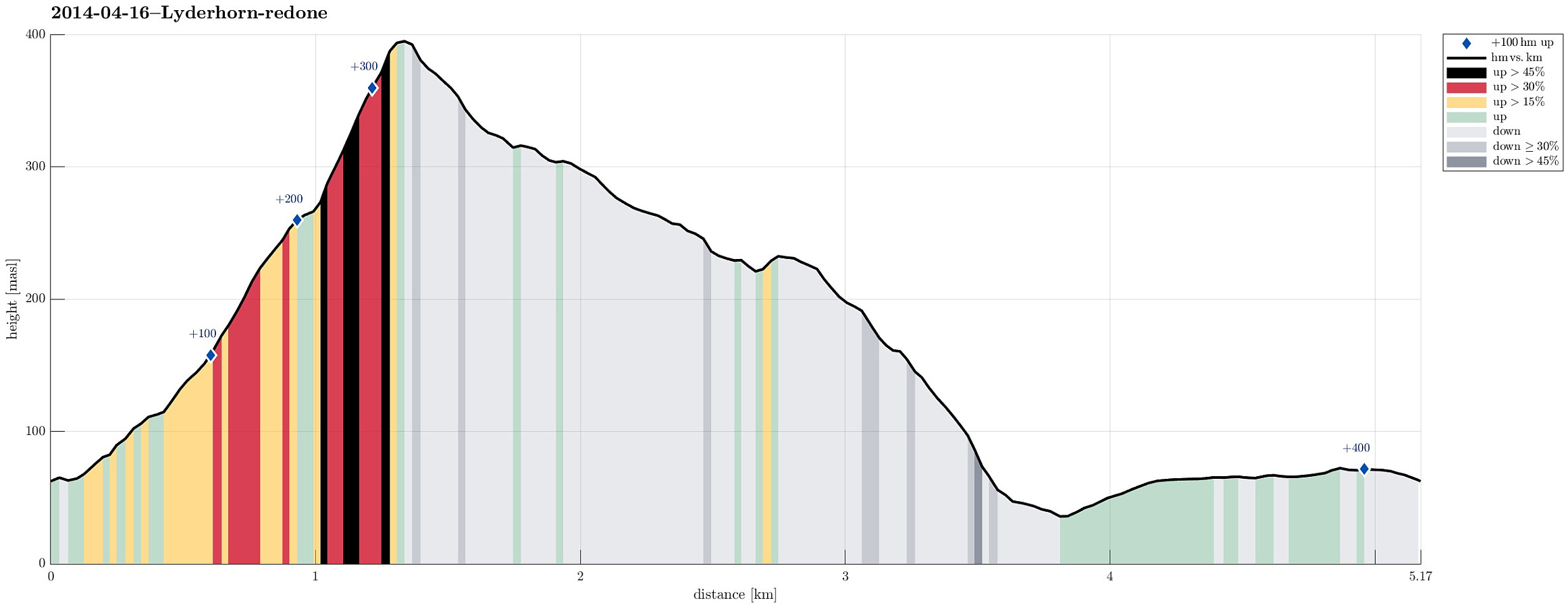 One of the many trip to Lyderhorn -- this time starting from Kjøkkelvik school, up a steep path to Lyderhorn, and then down to Kjøkkelvik -- very nice! :-)
Web page WestCoastPeaks.com provides useful information about Lyderhorn and Ørnafjellet
and also Petter Bjørstad has a page about Lyderhorn .
One of the many trip to Lyderhorn -- this time starting from Kjøkkelvik school, up a steep path to Lyderhorn, and then down to Kjøkkelvik -- very nice! :-)
Web page WestCoastPeaks.com provides useful information about Lyderhorn and Ørnafjellet
and also Petter Bjørstad has a page about Lyderhorn .
