Archiv - Nach Datum
Archiv - Nach Aktivität
-
Andere Tour (1)
- Kayaking (1)
-
Andere Wintertour (4)
- Schneeschuhtour (4)
-
Fahrradtour (137)
- Fahrradtour Straße (9)
- Fahrradtour gemischt (51)
-
Fußtour (740)
- Bergtour (363)
- Jogging (18)
- Spaziergang (89)
- Wanderung (270)
-
Skitour (4)
- Tourenskilauf (4)
Archiv - Nach Geografie
Peakbookfreunde


Gesammelte Listen
-
Bergen ≥ 50m pf. og ≥ 100 m.o.h.
(87/89)
 97%
97% -
Most dominating tops of the Bergen peninsula
(68/75)
90%
-
Utvalgte topper og turmål i Bergen
(316/350)
90%
-
Alle topper i Bergen
(357/398)
89%
-
Opptur Bergen
(100/113)
88%
-
De syv fjell rundt Bergen
(6/7)
85%
-
Sund ≥ 50m pf.
(14/18)
77%
-
Os ≥ 50m pf.
(25/34)
73%
-
Søyler (fastmerker) i Bergen
(68/100)
68%
-
Fjell ≥ 50m pf.
(21/32)
65%

Sandviksfjellet
- Datum:
- 29.12.2014
- Tourcharakter:
- Bergtour
- Tourlänge:
- 3:00h
- Entfernung:
- 10,3km
 Starting from Eidsvåg, following the street up to Munkebotn and then further up Sandviksfjellet. After a short break in the small hut at Aasebu, we continued to Fløyen and from there back down towards Mulen. Even though the weather was pretty wet, we still enjoyed some snow and a good hike! :-)
Web page UT.no from the Norwegian Trekking Association recommends a similar hike up Sandviksfjellet .
Starting from Eidsvåg, following the street up to Munkebotn and then further up Sandviksfjellet. After a short break in the small hut at Aasebu, we continued to Fløyen and from there back down towards Mulen. Even though the weather was pretty wet, we still enjoyed some snow and a good hike! :-)
Web page UT.no from the Norwegian Trekking Association recommends a similar hike up Sandviksfjellet .
Orrehaugane
- Datum:
- 27.12.2014
- Tourcharakter:
- Bergtour
- Tourlänge:
- 1:45h
- Entfernung:
- 4,9km
 Starting from Nattlandsfjellet, we first hiked up to Orrehaugane, mostly carrying our skies. Then, when meeting the main trail (also up from Nattlandsfjellet), we continued mostly on skies (also back to Nattlandsfjellet on the main trail).
Web page WestCoastPeaks.com provides useful information about Haugavarden, Ulriken, Storfjellet, and Landåsfjellet
and also Petter Bjørstad has a useful page about Ulriken .
Starting from Nattlandsfjellet, we first hiked up to Orrehaugane, mostly carrying our skies. Then, when meeting the main trail (also up from Nattlandsfjellet), we continued mostly on skies (also back to Nattlandsfjellet on the main trail).
Web page WestCoastPeaks.com provides useful information about Haugavarden, Ulriken, Storfjellet, and Landåsfjellet
and also Petter Bjørstad has a useful page about Ulriken .
Lyderhorn
- Datum:
- 25.12.2014
- Tourcharakter:
- Bergtour
- Tourlänge:
- 2:30h
- Entfernung:
- 7,8km
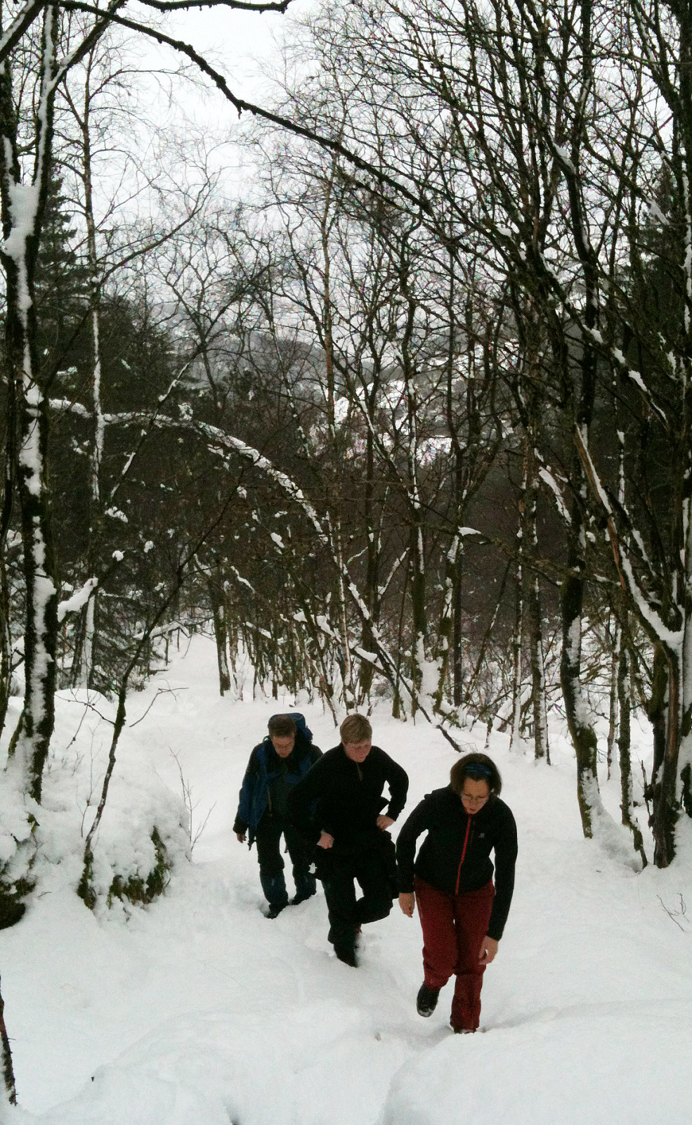
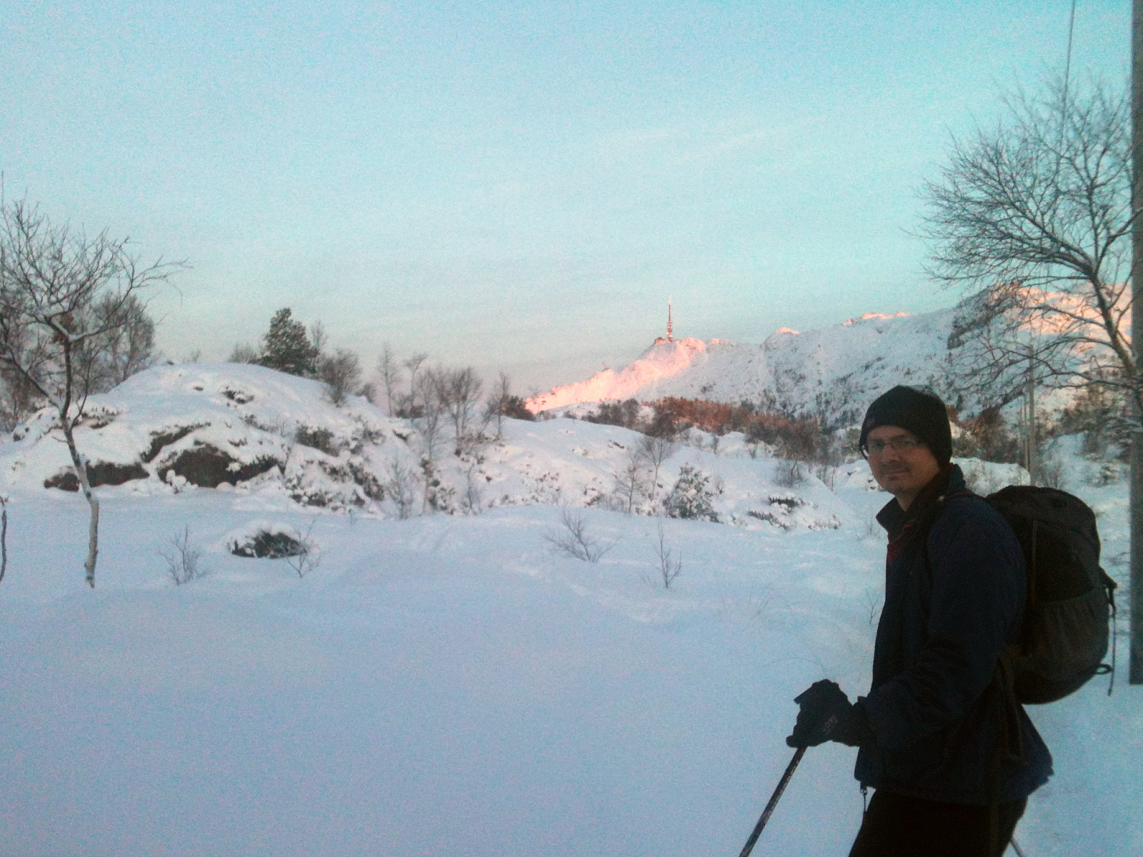
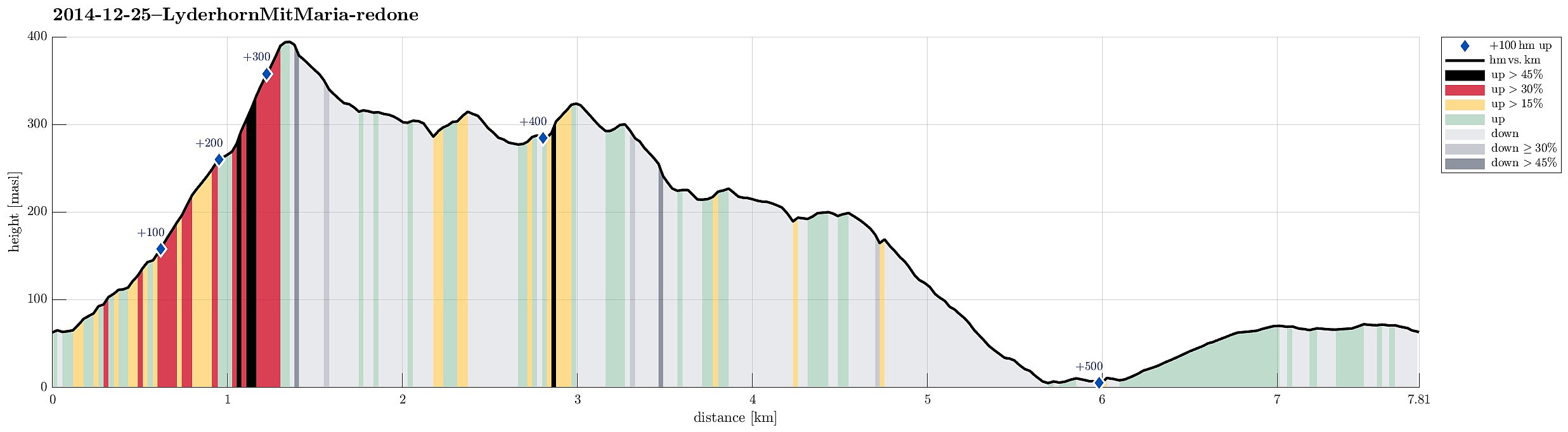 Very nice xMas hike up Lyderhorn and down to Kjøkkelvik (via Ørnafjellet)!
Web page WestCoastPeaks.com provides useful information about Lyderhorn and Ørnafjellet
and also Petter Bjørstad has a page about Lyderhorn .
Very nice xMas hike up Lyderhorn and down to Kjøkkelvik (via Ørnafjellet)!
Web page WestCoastPeaks.com provides useful information about Lyderhorn and Ørnafjellet
and also Petter Bjørstad has a page about Lyderhorn .
Løvstakken
- Datum:
- 29.11.2014
- Tourcharakter:
- Bergtour
- Tourlänge:
- 1:15h
- Entfernung:
- 4,5km
 Quick tour up and down Løvstakken (from Fyllingsdalen)
Web page WestCoastPeaks.com provides useful information about Løvstakken .
Quick tour up and down Løvstakken (from Fyllingsdalen)
Web page WestCoastPeaks.com provides useful information about Løvstakken .
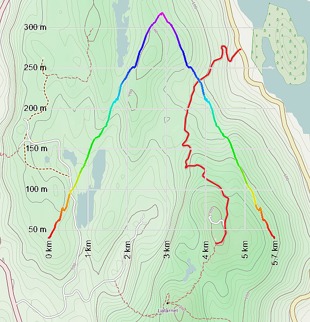
Spjeldsfjellet
- Datum:
- 26.10.2014
- Tourcharakter:
- Bergtour
- Tourlänge:
- 2:00h
- Entfernung:
- 6,6km
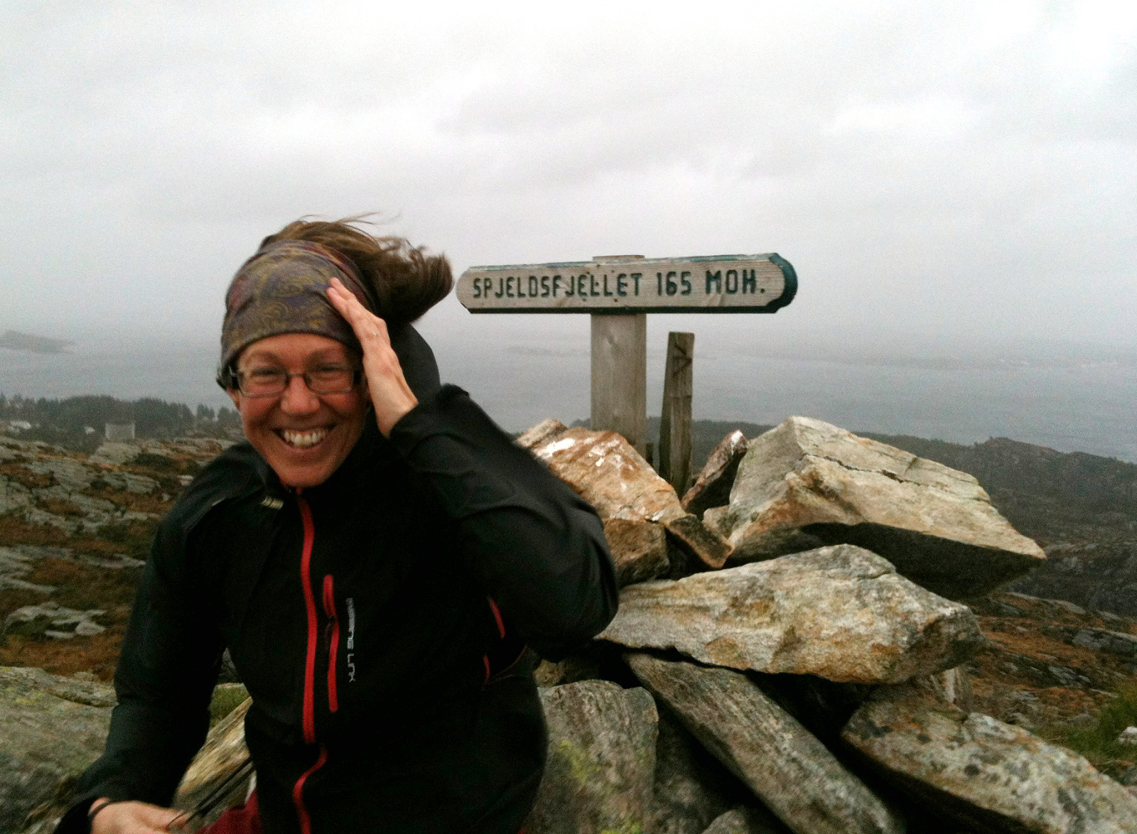 From road 210, some ~500m from Landrovegen, we first headed eastover (following an easy to find and well-used path), before we then started to ascend to Spjeldsfjellet. From the top, where we enjoyed extra-strong winds (so strong that it -- at times -- was difficult to prevent falling over!), we first descended towards Spjeldsunnet, before we then turned back (without path, approx. from km 3.6 to km 4.5), getting back to the same path which we had used first (slightly beneath Spjeldsfjellet). All in all a nice hike in stormy weather! :-)
Petter Bjørstad has a useful page about Spjeldsfjellet .
Web page UT.no from the Norwegian Trekking Association recommends another hike up and down Spjeldsfjellet .
From road 210, some ~500m from Landrovegen, we first headed eastover (following an easy to find and well-used path), before we then started to ascend to Spjeldsfjellet. From the top, where we enjoyed extra-strong winds (so strong that it -- at times -- was difficult to prevent falling over!), we first descended towards Spjeldsunnet, before we then turned back (without path, approx. from km 3.6 to km 4.5), getting back to the same path which we had used first (slightly beneath Spjeldsfjellet). All in all a nice hike in stormy weather! :-)
Petter Bjørstad has a useful page about Spjeldsfjellet .
Web page UT.no from the Norwegian Trekking Association recommends another hike up and down Spjeldsfjellet .
Arnanipa in wet-stormy autumn weather
- Datum:
- 25.10.2014
- Tourcharakter:
- Bergtour
- Tourlänge:
- 1:45h
- Entfernung:
- 10,3km
 While my son played some handball in Bjørnarhallen, this quick and wet hike unfolded in the midst of stormy autumn weather. The path up to Arnanipa was nice -- on the top of Arnanipa there was a strong wind, probably strom. The path down from the top was steep and very, very slippery -- not a good idea, actually, in the rain! The forest road, slightly above Arna, then was nice and relaxing for jogging back to Bjørnarhallen. All in all, a quick and refreshing tour! :-)
Web page WestCoastPeaks.com provides useful information about Skåldalsfjellet, Herlandsfjellet, Repparåsen, and Arnanipa .
While my son played some handball in Bjørnarhallen, this quick and wet hike unfolded in the midst of stormy autumn weather. The path up to Arnanipa was nice -- on the top of Arnanipa there was a strong wind, probably strom. The path down from the top was steep and very, very slippery -- not a good idea, actually, in the rain! The forest road, slightly above Arna, then was nice and relaxing for jogging back to Bjørnarhallen. All in all, a quick and refreshing tour! :-)
Web page WestCoastPeaks.com provides useful information about Skåldalsfjellet, Herlandsfjellet, Repparåsen, and Arnanipa .
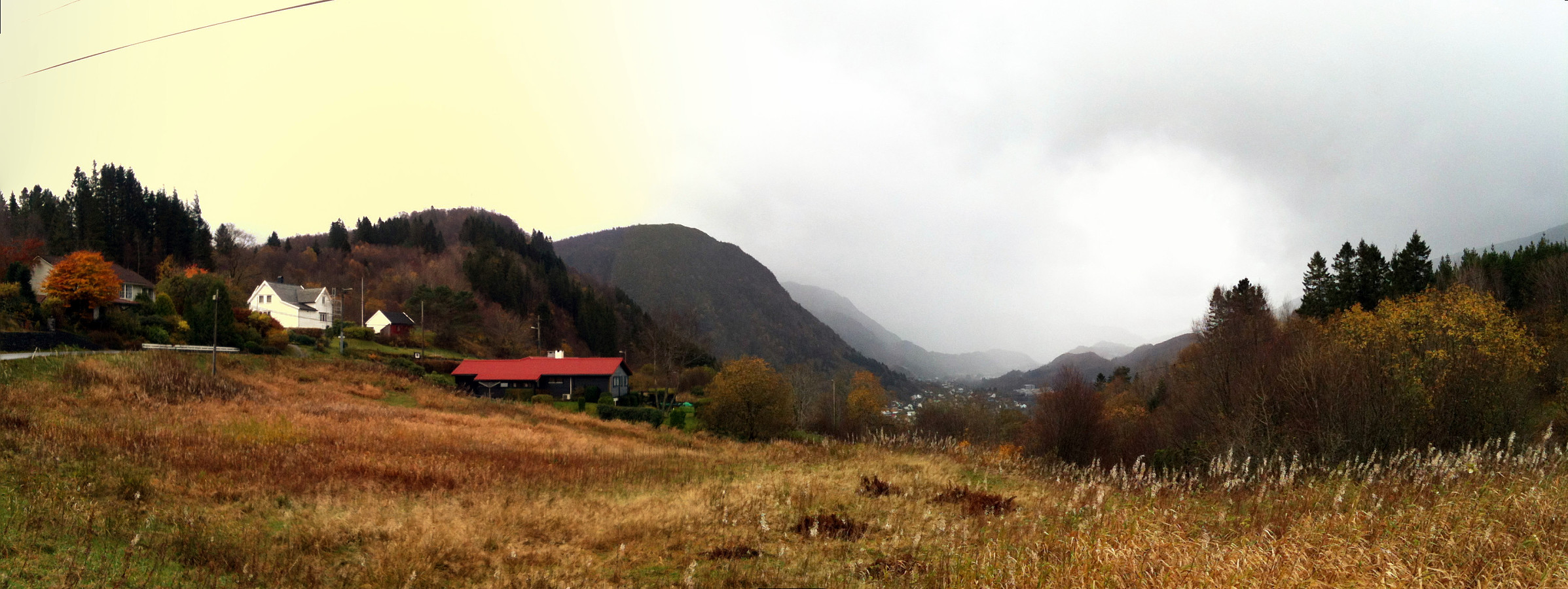
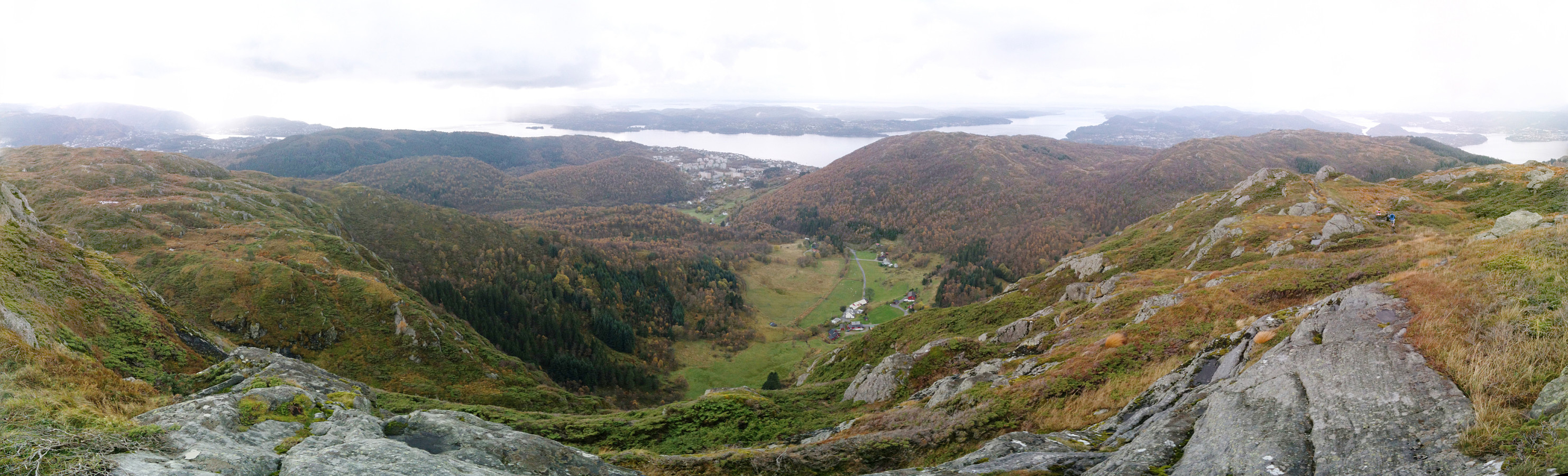
Liatårnet
- Datum:
- 18.10.2014
- Tourcharakter:
- Bergtour
- Tourlänge:
- 1:30h
- Entfernung:
- 5,8km
 Evening walk, almost in the dark, and in the middle of windy clouds (but with less rain than expected!) -- it's always nice to walk up and down Pyttane, especially, if there's limited time! :-)
Web page WestCoastPeaks.com provides useful information about Liatårnet
and also Petter Bjørstad has a useful page about Liatårnet .
Evening walk, almost in the dark, and in the middle of windy clouds (but with less rain than expected!) -- it's always nice to walk up and down Pyttane, especially, if there's limited time! :-)
Web page WestCoastPeaks.com provides useful information about Liatårnet
and also Petter Bjørstad has a useful page about Liatårnet .
Hike around Baugtveit with Høgstefjellet
- Datum:
- 12.10.2014
- Tourcharakter:
- Bergtour
- Tourlänge:
- 3:00h
- Entfernung:
- 8,9km
 We started from the parking place in Baugtveit (to right, right after driving up the steep road towards Baugtveit) and walked first along Huseberget and up towards Baugtveitgotene, then around Midtfjellet, and up to Høgstefjellet. From the beginning, this was a very wet hike -- and slippery in some places (due to the recent rain). We then continued northwards, via Baugtveitstemma up to Tellevikafjellet. From there, we went down to Salhusskaret and up, again, to Nordgardsfjellet. From there we continued on the path and down to Hitland (lowest point), before we walked to road up, again, to get back to the car. All in all, it was fun to make this hike (several tops and still well doable without being too straining). :-)
Selected photos are available as Google photo album .
Web page WestCoastPeaks.com provides useful information about Høgstefjellet, Tellevikafjellet, and Nordgardsfjellet
and also Petter Bjørstad has >>>
We started from the parking place in Baugtveit (to right, right after driving up the steep road towards Baugtveit) and walked first along Huseberget and up towards Baugtveitgotene, then around Midtfjellet, and up to Høgstefjellet. From the beginning, this was a very wet hike -- and slippery in some places (due to the recent rain). We then continued northwards, via Baugtveitstemma up to Tellevikafjellet. From there, we went down to Salhusskaret and up, again, to Nordgardsfjellet. From there we continued on the path and down to Hitland (lowest point), before we walked to road up, again, to get back to the car. All in all, it was fun to make this hike (several tops and still well doable without being too straining). :-)
Selected photos are available as Google photo album .
Web page WestCoastPeaks.com provides useful information about Høgstefjellet, Tellevikafjellet, and Nordgardsfjellet
and also Petter Bjørstad has >>>
Via Gråfjellet towards Sveningen
- Datum:
- 05.10.2014
- Tourcharakter:
- Bergtour
- Tourlänge:
- 6:30h
- Entfernung:
- 18,1km
 We parked the car in Løyningdalen, right next to the street into Øvredalen. We then crossed the river (bridge) and continued into Stordalen. Following Stordalen, we passed by Gråfjellet and climbed up to Midtfjellet first. From there, we changed over to Gråfjellet, going a bit back in direction. From Gråfjellet, we then descended to Leina and followed the ridge in direction Baggeskaret. Most of this is without any path and you better have a bit of an adventure-spirit to try this connection. From there we continued along the ridge, first via Selsfjellet and then to Utløfjellet, before we started a quite steep ascent towards Sveningen. Basically, most of this tour was along the border between Os and Samnanger. See the image for the part of the trip which was (too?) steep. Maybe, >>>
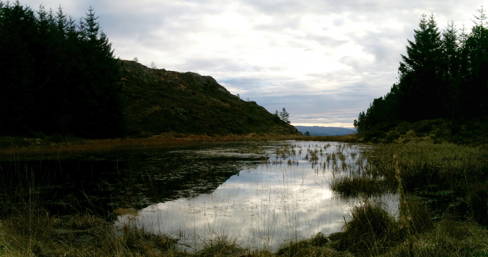
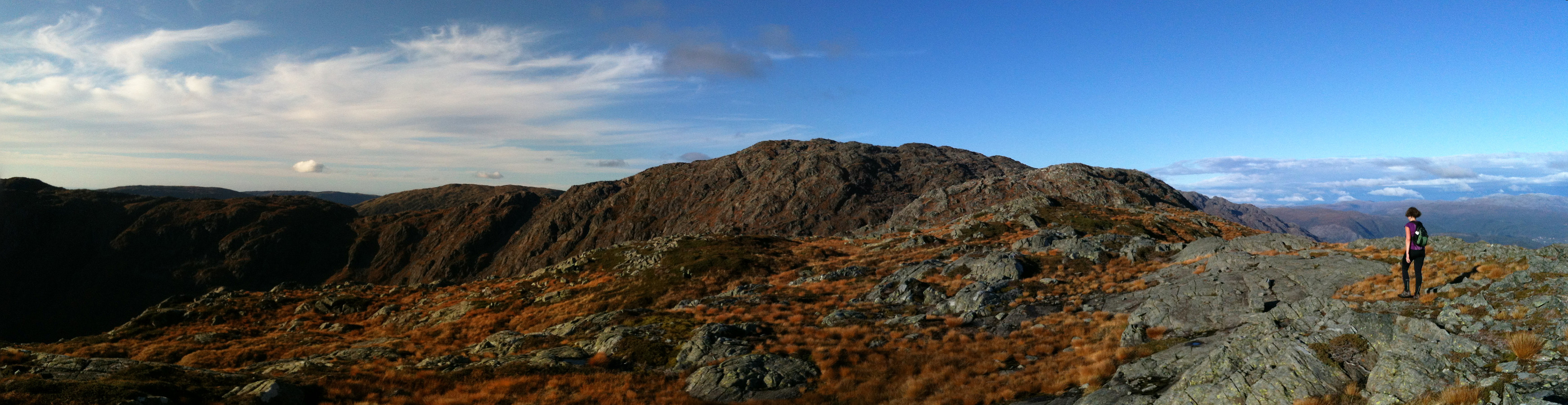
Skogsøy in stormy weather
- Datum:
- 04.10.2014
- Tourcharakter:
- Bergtour
- Tourlänge:
- 3:00h
- Entfernung:
- 5,5km
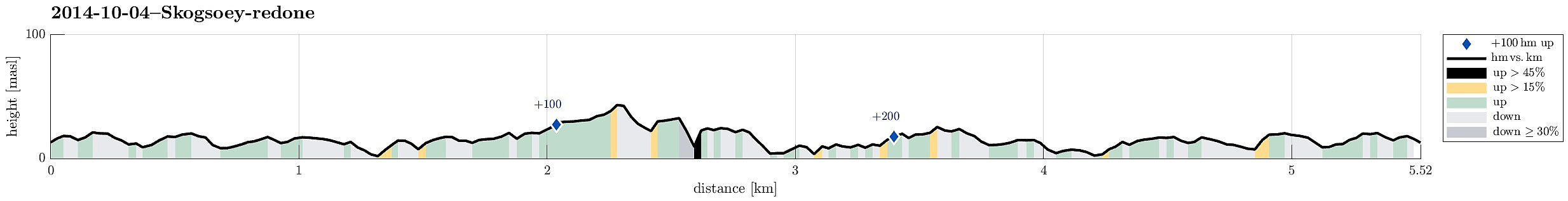 With the weather being quite stormy, this was an exciting tour to Skogsøy! :-) It's one of the view places, which I know and appreciate, where you get close to the open north sea, here in the vicinity of Bergen -- a place to return to again and again!
Selected photos are available as Google photo album .
With the weather being quite stormy, this was an exciting tour to Skogsøy! :-) It's one of the view places, which I know and appreciate, where you get close to the open north sea, here in the vicinity of Bergen -- a place to return to again and again!
Selected photos are available as Google photo album .
