Archiv - Nach Datum
Archiv - Nach Aktivität
-
Andere Tour (1)
- Kayaking (1)
-
Andere Wintertour (4)
- Schneeschuhtour (4)
-
Fahrradtour (137)
- Fahrradtour Straße (9)
- Fahrradtour gemischt (51)
-
Fußtour (740)
- Bergtour (363)
- Jogging (18)
- Spaziergang (89)
- Wanderung (270)
-
Skitour (4)
- Tourenskilauf (4)
Archiv - Nach Geografie
Peakbookfreunde


Gesammelte Listen
-
Bergen ≥ 50m pf. og ≥ 100 m.o.h.
(87/89)
 97%
97% -
Most dominating tops of the Bergen peninsula
(68/75)
90%
-
Utvalgte topper og turmål i Bergen
(316/350)
90%
-
Alle topper i Bergen
(357/398)
89%
-
Opptur Bergen
(100/113)
88%
-
De syv fjell rundt Bergen
(6/7)
85%
-
Sund ≥ 50m pf.
(14/18)
77%
-
Os ≥ 50m pf.
(25/34)
73%
-
Søyler (fastmerker) i Bergen
(68/100)
68%
-
Fjell ≥ 50m pf.
(21/32)
65%

Winter excursion to Höllenstein
- Datum:
- 25.12.2006
- Tourcharakter:
- Bergtour
- Tourlänge:
- 3:00h
- Entfernung:
- 8,7km
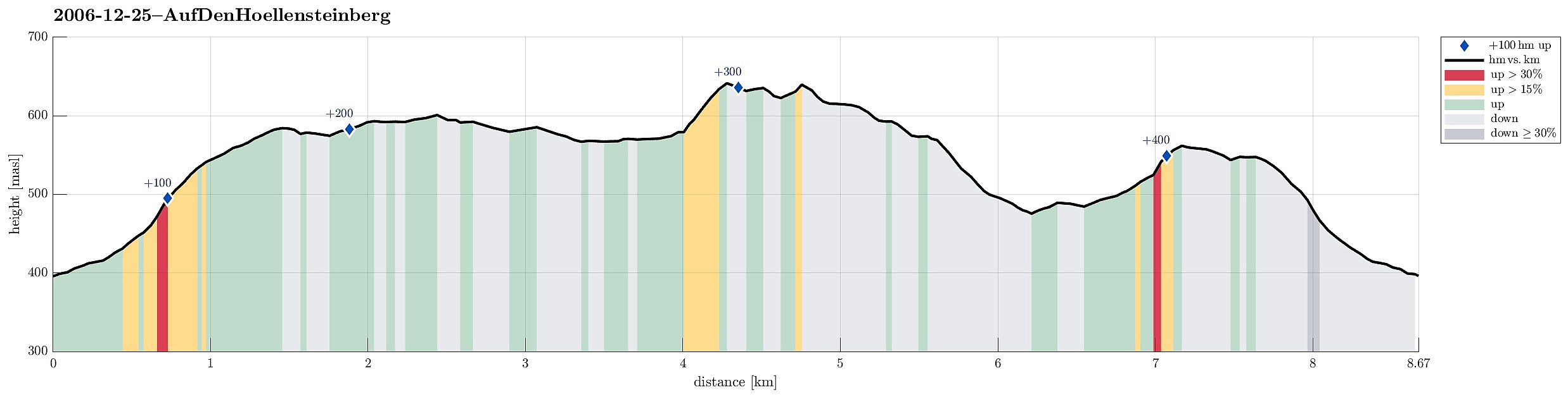 This time, we started from Rohrberg and headed eastwards towards Höllensteinberg. In nice winter weather, we ascended to the heights around J.-Schöffel-Hütte and continued via Kreuzsattel towards Höllensteinberg. Instead of directly ascending to its top right away, we first surrounded it and got up to the top from the east. We then continued in western direction, making use of some simple sledges that we had brought along (this turned out to be way more dangerous than anticipated, due to the steep descent from Höllenstein!). After having returned to Kreuzsattel, we followed the Nordalpenweg down into the direction of Sittendorf/Wildegg. Once we were down to the Sparbach, we crossed it and ascended again (via Hausberg) into order to get over and back to Rohrberg.
See also the related >>>
This time, we started from Rohrberg and headed eastwards towards Höllensteinberg. In nice winter weather, we ascended to the heights around J.-Schöffel-Hütte and continued via Kreuzsattel towards Höllensteinberg. Instead of directly ascending to its top right away, we first surrounded it and got up to the top from the east. We then continued in western direction, making use of some simple sledges that we had brought along (this turned out to be way more dangerous than anticipated, due to the steep descent from Höllenstein!). After having returned to Kreuzsattel, we followed the Nordalpenweg down into the direction of Sittendorf/Wildegg. Once we were down to the Sparbach, we crossed it and ascended again (via Hausberg) into order to get over and back to Rohrberg.
See also the related >>>
Cycling between Triesting and Piesting
- Datum:
- 06.07.2006
- Tourcharakter:
- Fahrradtour
- Tourlänge:
- 3:00h
- Entfernung:
- 47,1km
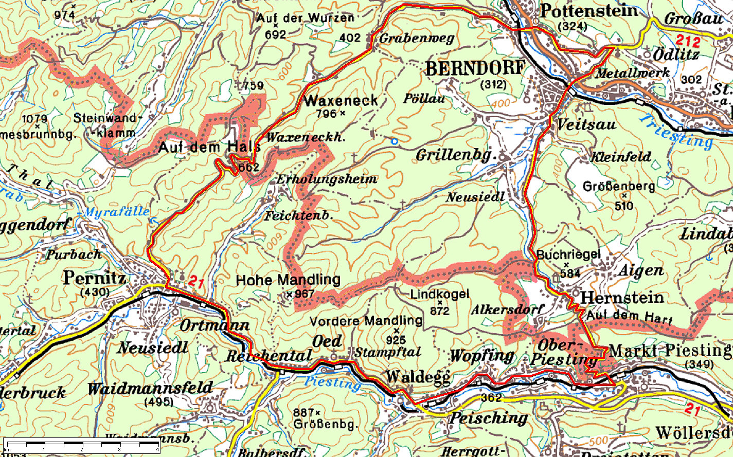 We started this bike trip near Medauhof, between Ödlitz and Berndorf. From there, we first descended towards Pottenstein an der Triesting, where we changed over to the other side of the valley. From there, we entered the long and nice Grabenweg-valley, which leads up to the saddle Am Hals at its very end. Mostly, this road is leading gently upwards, but at its very end, it becomes a little steeper and a nice challenge for cyclists, not talking here about challenges, which aggressive drivers occasionally impose on those on two wheels! On the other side of the saddle, we clearly enjoyed a longer and faster descent into the valley, which brings on out to Perniz. There, we basically turned left (into eastern direction) and followed the Piesting for quite a while on its way out of the mountains. >>>
