Around Løvstakken (and up to it, too) (15.06.2024)

| Startpunkt | Varden (45m) |
|---|---|
| Endpunkt | Varden (45m) |
| Tourcharakter | Fahrradtour gemischt |
| Tourlänge | 4h 00min |
| Entfernung | 22,9km |
| Höhenmeter | 1.001m |
| GPS |
|
| Besteigungen | Løvstakken (478m) | 15.06.2024 |
|---|---|---|
| Besuche anderer PBE | Krohnegården Sør p-plass (169m) | 15.06.2024 |
| Krohnegården nord p-plass (152m) | 15.06.2024 | |
| Løvstien Nord (80m) | 15.06.2024 | |
| Minnesmerke bomberaid 1945 Løvstien (125m) | 15.06.2024 | |
| Sælen kirke p-plass (15m) | 15.06.2024 | |
| Utsikt øst for Løvstakken (420m) | 15.06.2024 |
Trip Summary
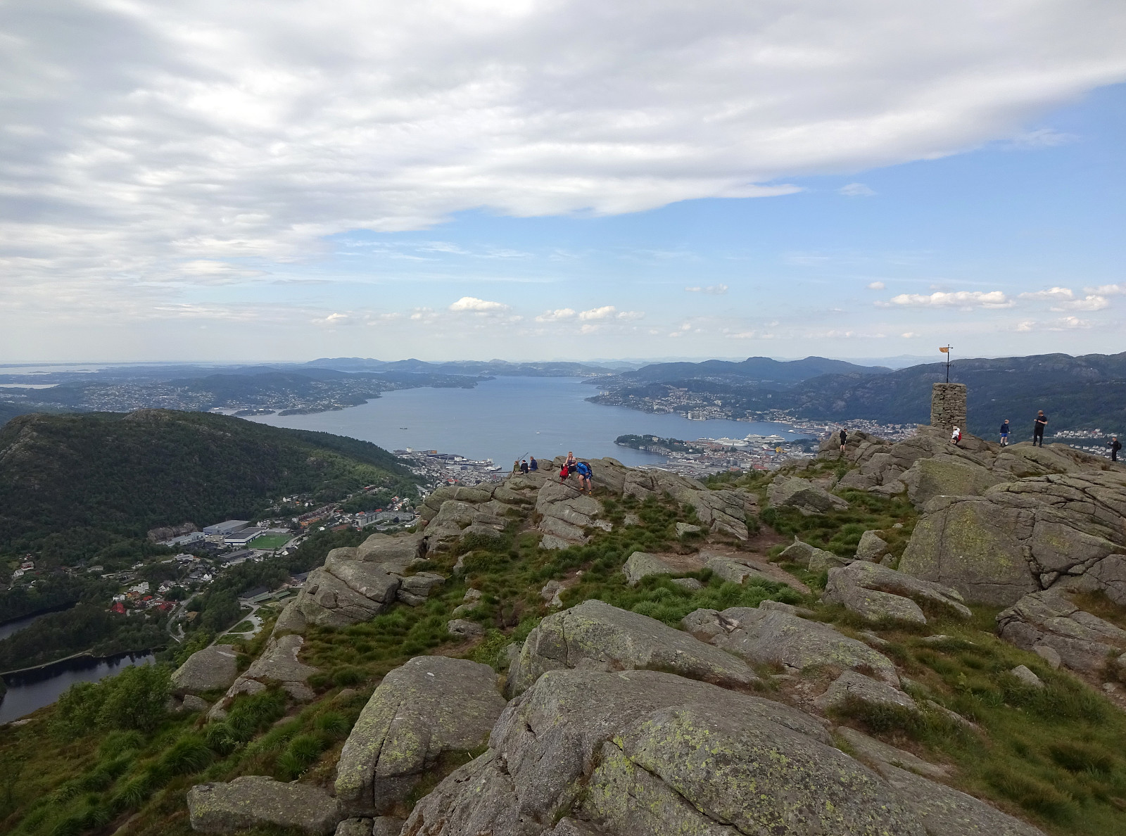
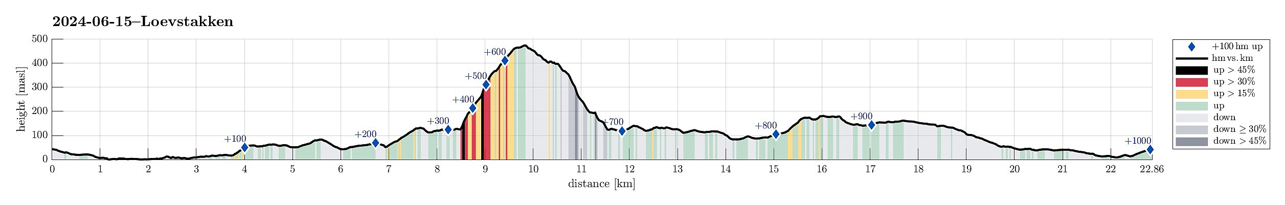
We combined two ideas: Cycle along Løvstien and visit Løvstakken. We started at Varden and biked around Sælevatnet, continuing then along Straumeveien until we came to Bøneset. There we crossed under the main road to then ascend towards Storahugen and further to Kråkenes. Following road Øvre Kråkenes, we got to the start point of Løvstien (on its southern end). We then biked along Løvstien, passing by Lerkhaugen and Lisahaugen, until we were close to Grønnestølen. At about (5.3307E/60.3549) we then parked our bikes at the side of Løvstien, where also a trail from Grønnestølstunet comes up. From there, we then started our ascent towards Løvstakken, starting in southwestern direction (up towards a small saddle that would bring us over and into "Dalen"). While one can see that others have stepped up there before, it's too much to state that there would be a trail. Once over the saddle, we turned northwards, continuing our ascent -- now along Dalen (between a stream on the west and a little but still significant cliff on the east). Once up to about 250 masl, Dalen widens a little bit and one can find a trail that continues further northwards (and out of Dalen, heading almost straight towards a big mast of the power line which crosses over there between Gullsteinen in the south and Løvstakken in the north). This ascent aligns with a little side-stream and before we got up to about 300 masl, we stepped out of this gully towards the northwest. Following the small trail there, we continued our (steep) ascent towards Løvstakken. At about 370 masl, this trail merges with a slightly larger trail, coming up from the west, and it becomes "straight-forward" to follow this trail all the way up to Løvstakken. Without spending much time on the top, we immediately started our descent back down again -- this time first in eastern direction. First, we followed a major trail, but soon we diverted to the south-east (in order to connect back to Dalen, after all). At about 420 masl, we found ourselves on a nice high-spot with a great panoramic view over Bergen. From there, it was then mostly towards the south. Some 25 height meters further down, we connected to a trail that comes up from the northeast there. Following this trail for a few meters, we were back to the trail that we had first taken up to Løvstakken. Following this trail back down, we arrived soon at this little saddle that we first used to get into Dalen. Instead of continuing back down along the same route that we had taken up there, however, we first continued a bit further southwards. This brought us to a little high-point (at about 200 masl), where apparently people have some good time every now and then. :-) Descending further southwards from there got significantly steep, but it's fair to mention that one can find a simple trail there. Once down to about 150 masl, we turned back north/northeast to get back to Løvstien and our bikes. We then continued our bike-round around Løvstakken, following Løvstien (in particular the new stretches of Løvstien, of which some have become quite impressive!). Following Løvstien all the way to its northwestern end, made it to Øvre Riplegården. Via Klauvsteinen, we connected to Krohnegården and following this road, we made it back into Fyllingsdalen. All in all, it was nice to combine a biking round around Løvstakken with a short visit to its top! :-)
Photos
Selected photos are available as Google photo album.
Useful Resources
See also the related FB-page Hiking around Bergen, Norway.
Web page WestCoastPeaks.com provides useful information about Løvstakken.

Benutzerkommentare