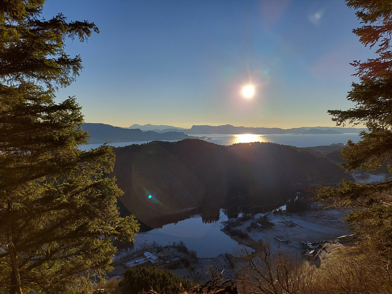
Møsnuken from Hegglandsdalen barneskole (03.12.2022)

| Startpunkt | Hegglandsdalen barneskole (70m) |
|---|---|
| Endpunkt | Hegglandsdalen barneskole (70m) |
| Tourcharakter | Wanderung |
| Tourlänge | 4h 00min |
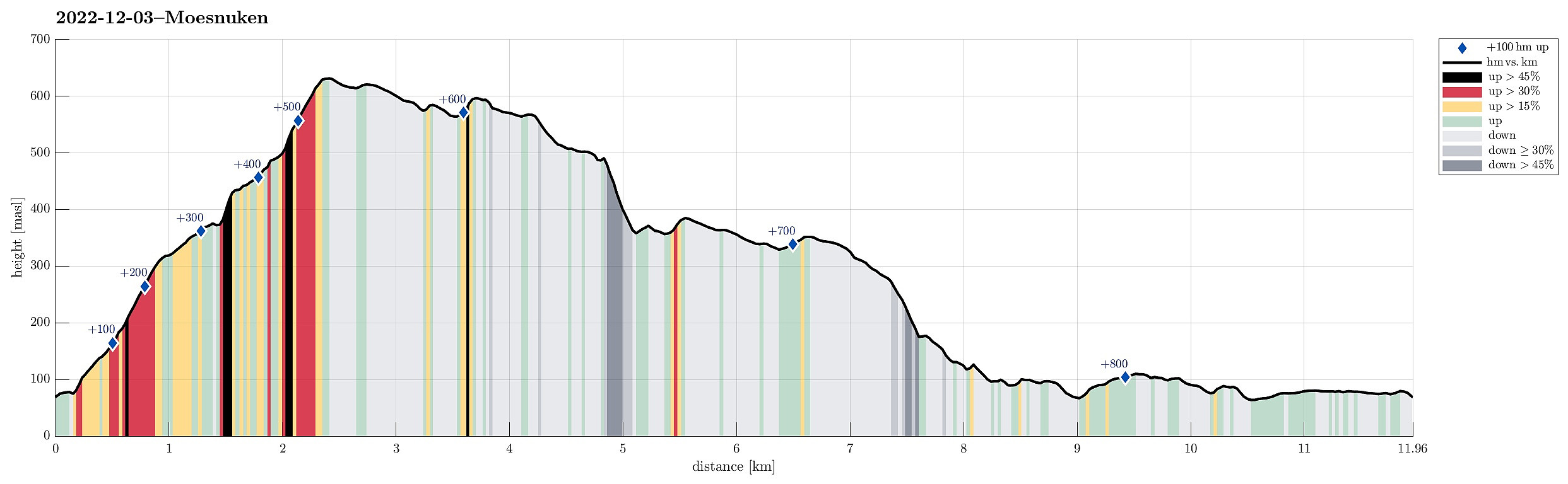
| Entfernung | 12,0km |
| Höhenmeter | 857m |
| GPS |
|
| Besteigungen | Møsnuken (639m) | 03.12.2022 |
|---|---|---|
| Storafjellet (592m) | 03.12.2022 | |
| Søre Såta (578m) | 03.12.2022 | |
| Tyssdalsfjellet (605m) | 03.12.2022 | |
| Besuche anderer PBE | Borgly (354m) | 03.12.2022 |
| Tysk flyvinge fra 1942 (319m) | 03.12.2022 | |
| Flyvrak - JU88 fra 1942 (401m) | 03.12.2022 |
Trip Summary
YR predicted a really nice winter day: a perfect invitation to get out! :-) Without too much comparison of all the possible nice hikes, I decided to make another attempt to ascend to Møsnuken from the southeast. I had read here on Peakbook about a trail that leads up to Tveitaberget from Hegglandsdalsvegen where it passes the primary school of Hegglandsdalen (Hegglandsdalen barneskole). And indeed there's a proper trail with a well-marked trail head next to house #528 along Hegglandsdalsvegen, which leads up along a curved ridge to Tveitaberget. According to the terrain, this trail is very steep, but just fine to step up there! :-) Once on Tveitaberget, the trail "flattens out" a little, leading then in northward direction. At about 355masl, the trail turns left to ascend steeply (for just a few meters) to "another level". There, one meets another trail that is coming up there (kind of "in parallel" to Møsnuken) from Gjemdalen. Following this trail (into the direction of Gjemdalen, instead of turning further left and upwards toward Møsnuken) for just about 200m, one gets to one of the places, where the remains of a German war plan are visible that crashed into Møsnuken in early 1942. Following an indication that further up additional pieces are to be seen, and expecting another trail "parallel to Møsnuken" up there, I ascended directly upwards (quite steep, there, requiring the use of both hands to help with the ascent). A few minutes later, I then found the other site. From there, I then followed this other, upper "parallel trail", now in southwestward direction in order to get further up on Møsnuken. This lead me up to 500masl (easily and nicely), where I decided to leave the trail and short-cut "directly" upwards, aiming at the trail up to the top of Møsnuken a bit further up. Getting up there was quite nicely possible (without any real challenges) and soon later I had reconnected with the trail to the top of Møsnuken, which I then followed to the top. Enjoying the nice day, I decided to do a bit of a traverse over the heights of Møsnuken (in southwestern direction), first towards Storafjellet, then up to Tyssdalsfjellet, before continuing towards Søra Såta from there. The heights of Møsnuken are easy-going so that there isn't really a need to stick to the trails. When aiming at a descent towards the southeast, however, for example, to get down into Tyssdalen, one should be a bit careful and better use one of the available trails. When on Søra Såta, I somehow thought that I could connect towards one of these trails in southwestern direction (the one that connects Linken with Tyssdalen), while still on the heights. I therefore descended from Søra Såta (without a trail) along its southwestern ridge. This is easy going, so I was hopeful that my plan would work out without challenges. Once down to about 515masl, the terrain flattens out and walking across this plateau is quite nice and easy, even without a trail. The further I came towards the southwest of this plateau, however, the more I got the impression that my expectation to meet the targeted trail high up had been too optimistic. Instead I ended up in a steep gully, leading down towards Grytelia. I clearly considered turning around and hiking back up (in northwestern direction, if possible) to meet the main trail that extends there, but then gave this descent into Grytelia a try nonetheless. While some care was necessary, I then found that it was indeed possible to get down there without all too much difficulty (I wouldn't do it again, however, I think). Some 100 height meters further down, I then met the trail that I had wished to meet much higher up, leading me then easily and safely into Tyssdalen near Grytestølen. Once there, I started to focus on the next big question: How to get back to Hegglandsdalen without any all too long detour. Since day light is short, even on nice winter days as this one, I really wanted to stay on a trail, if possible at all (and avoid ending up half way up in some steep terrain without any trail when it gets dark). After asking two other hikers about whether they knew of any such trail, leading more or less directly towards Hegglandsdalen, I decided to follow a safe but longer route that first brought me quite a bit towards Borgafjellet (wrong direction!). Quite a bit later, when already hiking along Hegglandsdalen, I saw a sign indicating a trail towards Møsnuken near house #370 along Hegglandsdalsvegen -- one day, I should explore this trail! :-) So, instead of this more direct route down, I crossed Gryteskaret and followed the good trail into the direction of Borgafjellet. Maybe about half a kilometer before reaching Borgafjellet, I then followed a sign that marked a trail into the direction of Hjelle. First I had thought that this trail would lead downwards quite a bit earlier -- instead, it lead me "in parallel" of Borgafjellet for quite a stretch (still in the wrong direction), before then turning left and down towards Haggardslia. Once stepping out of the forest there, I decided to leave the trail and try my luck on a more direct route towards the east. While not really on much of a trail (or trails), I still found it quite doable to traverse Hegglandsliane on a line that extended a couple of dozens of meters above the valley floor. While not difficult to traverse, I also could not say that this stretch of this hike was the most beautiful or enjoyable. At least, I could avoid a longer walk along on the road, which I really did not like as a prospect very much. Crossing some more minor heights in the northwest of the road, I connected to Heggland and the place where a trail up to Møsnuken is marked (as mentioned above). About there, I then decided to abandon any further attempts to stay away from the road, following it back to Hegglandsdalen barneskole. Finding and exploring the trail from there up to Møsnuken was definitely a positive discovery. Making this hike into a round could see some improvements, though. :-)
Photos
Selected photos are available as Google photo album.
Useful Resources
See also the related FB-page Hiking around Bergen, Norway.
Web page WestCoastPeaks.com provides useful information about Møsnuken and Tyssdalsfjellet
and also Petter Bjørstad has a useful page about Møsnuken.

Benutzerkommentare