Lyshornet from Lysekloster (03.09.2022)

| Startpunkt | Lysekloster (50m) |
|---|---|
| Endpunkt | Lysekloster (50m) |
| Tourcharakter | Wanderung |
| Tourlänge | 2h 30min |
| Entfernung | 7,3km |
| Höhenmeter | 487m |
| GPS |
|
| Besteigungen | Lyshornet (405m) | 03.09.2022 |
|---|---|---|
| Vetla Lyshornet (366m) | 03.09.2022 | |
| Besuche anderer PBE | Grønhovda utsiktspunkt (296m) | 03.09.2022 |
| Lysekloster p-plass (50m) | 03.09.2022 | |
| Ruinene på Lysekloster (53m) | 03.09.2022 |
Trip Summary
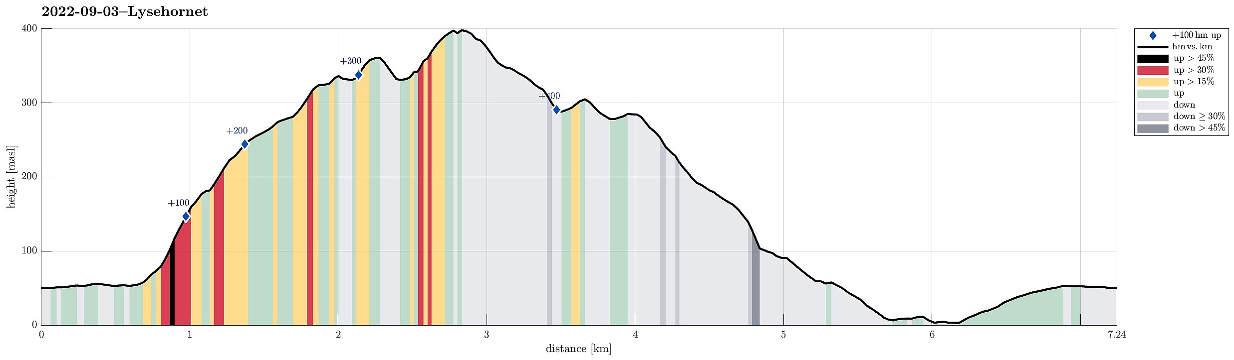
To get some fresh air, we decided to do a simple hike, not far from home: Lyshornet. We parked near Lysekloster and followed the main trail to Lyshornet from there. This lead us up to Lyshornskaret from where a short detour to Vetla Lyshornet was included. After enjoying the day for a moment on Lyshornet, we then started our hike down, following a trail towards the west from the top. This trail leads one down to the service road, which leads up to Ulvvatnet from Lyseklostervegen. Once on this road, it was then to first walk it down, before then following Lyseklostervegen back up to where we had parked. Clearly a nice little round with some nice views from Lyshornet.
Photos
Selected photos are available as Google photo album.
Useful Resources
See also the related FB-page Hiking around Bergen, Norway.
Petter Bjørstad has a useful page about Lysehornet and also web page WestCoastPeaks.com provides useful information about Lysehornet.
Web page UT.no from the Norwegian Trekking Association recommends the same route up.

Benutzerkommentare