Eggene (and back via Raudlifjellet) (19.09.2021)

| Start point | Bahus (60m) |
|---|---|
| Endpoint | Bahus (60m) |
| Characteristic | Hike |
| Duration | 3h 00min |
| Distance | 6.9km |
| Vertical meters | 528m |
| GPS |
|
| Ascents | Eggene (198m) | 19.09.2021 |
|---|---|---|
| Høghaugen (162m) | 19.09.2021 | |
| Nordhordlandskulten (389m) | 19.09.2021 | |
| Raudlifjellet (395m) | 19.09.2021 | |
| Visits of other PBEs | Eggene trigpunkt (188m) | 19.09.2021 |

Trip Summary
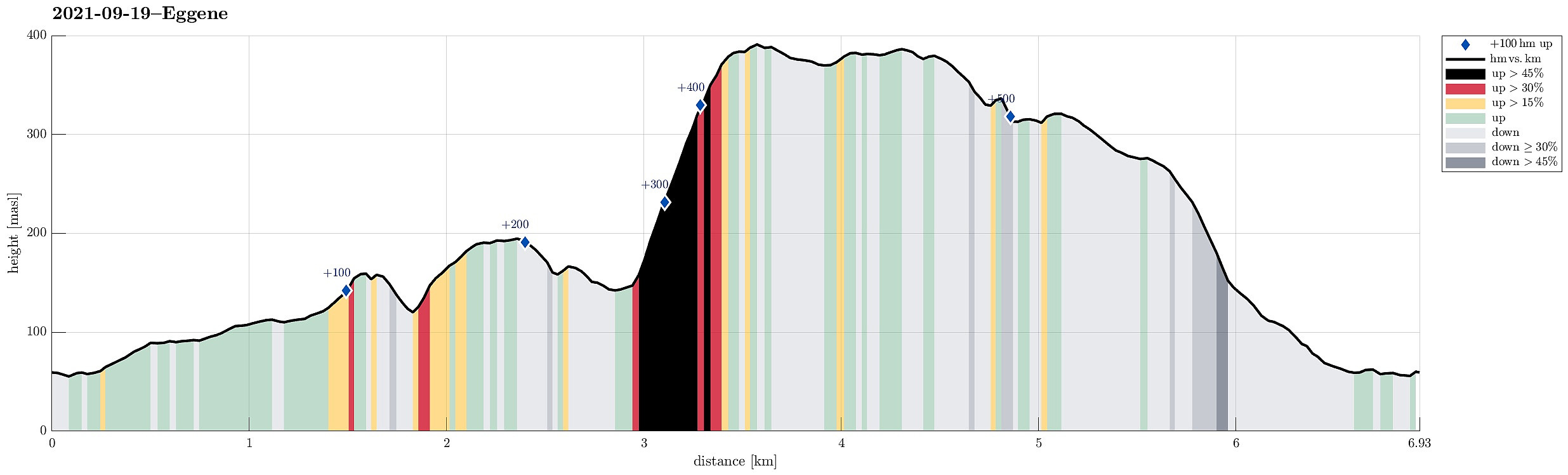
With most of the day overcast, the day's goal was an excursion into the forest in the southeast of Hausdalen. We drove first along E39 into the south of Bergen, parking not far from this road near Bahus. From there, we first walked along the road, crossing Straumen on the road's bridge, before quickly finding a tractor road that would lead us behind the houses (in northeastern direction, towards Storerinden). Once past the houses, we also left the tractor road, ascending to the gentle ridge (Storerinden). Once on the ridge, it was then straight-forward and easy to follow it (in northeastern direction). This way, one gets directly to Høghaugen (in the northwest of Breidalen) with some first nice views into Hausdalen (and down to Hauglandsvatnet). To connect further to Eggene, one needs to descend (a bit), first. Since the southeastern side of Høghaugen is really steep, the descent leads first in northern direction, before turning back into eastern direction. Once over the saddle, the ascent to Eggene begins, which is nice and easy from there (other sides of Eggene are very steep, also). Once up on the ridge of Eggene, it's again straight-forward and easy to cross over Eggene in northeastern direction. When descending from Eggene in the north, one follows the ridge "all the way down" to the saddle that separates Eggene from another small hill a bit further in the northeast. It's also easy to cross over that hill (from the southwest to the northeast). Once back "down" from this little bonus hill, I turned a bit further eastwards, crossing over the little stream that heads down to Tjørna (a bit further in the northeast). While not going down to Tjørna, I still had some nice views to it (through the trees), but since my plan was to ascend to Raudlifjellet from there, I did not see the point to descend further there. Instead, I turned further to the right, eventually embarking on my ascent to Raudlifjellet in southeastern direction from just above Tjørna. In a way, I possibly got a bit too optimistic with that choice as Raudlifjellet is really quite a bit steep on its northwestern flank, called Austerlia (it's also very steep on its southeastern flank!). In order to really get up to the ridge, I needed to help with my hands regularly during this ascent. After a while, I had made it to the ridge of Raudlifjellet, feeling a bit of a relief, also. From there, I then followd the ridge "back" (in southwestern direction), crossing over Ørnahaugen on my way to Nordhordlandskulten. There, I had planned to deviate from the trail, again, in order to descend via a ridge more in the north of the western end of Raudlifjellet. While I successfully made it to Vesterkulten, first, I descended along it for a bit too long, requiring a little bit of back-tracking in order to find a good spot for crossing over the little valley underneath in the west. This, however, did only take a few minutes and within short I arrived at the targeted ridge in the northwest of this little valley. Following this ridge, I then descended via Varden to Trolldalshaugen along this ridge. A bit further down, I then started to descend away from the ridge (mostly in western direction), being reminded that the mountain side is substantially steep there, also. With a bit of extra care, however, I made it down to another tractor road that I had remembered from studying the map at home. Once on this tractor road, it was then easy to walk it out and back to the car. All in all, this excursion reminded me of how steep the two flanks of Raudlifjellet actually are -- something that's easy to forget, given that Raudlifjellet by itself is not standing out of the landscapte very prominently, really.
Photos
Selected photos are available as Google photo album.
Useful Resources
See also the related FB-page Hiking around Bergen, Norway.
Petter Bjørstad has a useful page about Raudlifjellet and also web page WestCoastPeaks.com provides useful information about Raudlifjellet.

User comments