Holefjellet via Storhovden, Eikelifjellet, Gravdalsfjellet (13.02.2021)

| Startsted | Varden (45moh) |
|---|---|
| Sluttsted | Varden (45moh) |
| Turtype | Fjelltur |
| Turlengde | 3t 00min |
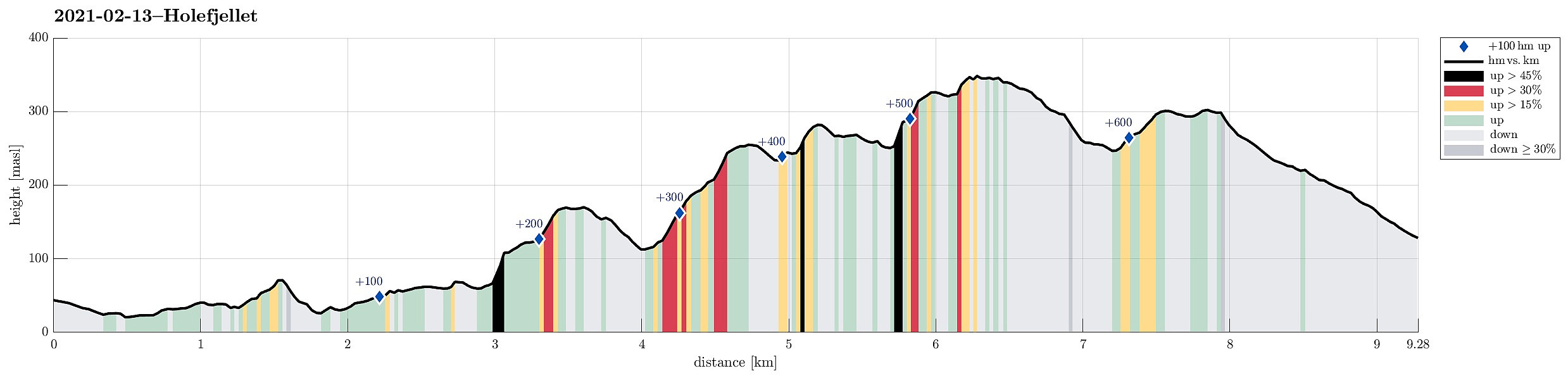
| Distanse | 9,3km |
| Høydemeter | 659m |
| GPS |
|
| Bestigninger | Allestadhaugen (78moh) | 13.02.2021 |
|---|---|---|
| Eikelifjellet i Bergen (258moh) | 13.02.2021 | |
| Gravdalsfjellet (353moh) | 13.02.2021 | |
| Holefjellet Sør (305moh) | 13.02.2021 | |
| Storhovden (174moh) | 13.02.2021 | |
| Vest for Fyllingsnipa (286moh) | 13.02.2021 | |
| Andre besøkte PBE'er | Chr. Sundts hytte (ruin) (218moh) | 13.02.2021 |
| Eikelisteinen (250moh) | 13.02.2021 | |
| Holefjellet utsikt vest (303moh) | 13.02.2021 | |
| Byste C. G. Sundt (210moh) | 13.02.2021 | |
| Nordnæsdalen parkering (192moh) | 13.02.2021 | |
| Storhovden utsiktspunkt (172moh) | 13.02.2021 |
Trip Summary
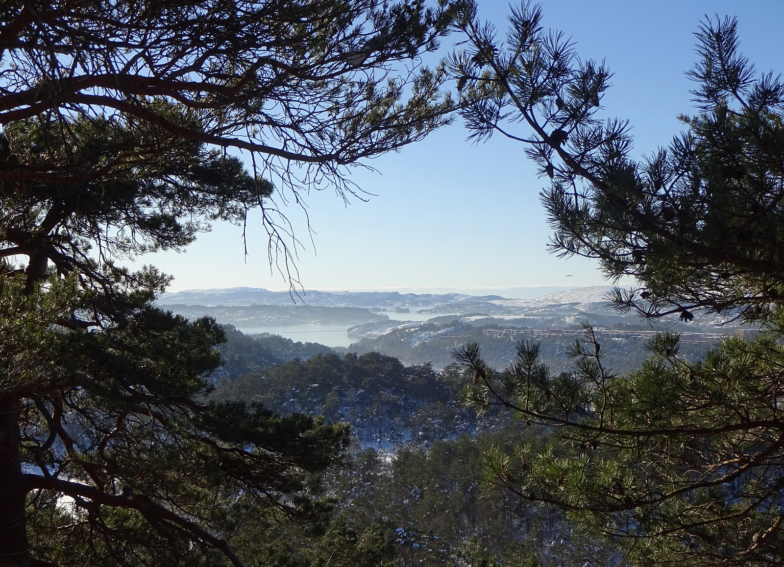
Expecting the unusually stable winter weather to end soon, we decided to get out and enjoy both sun and snow directly where we live, doing "nothing else" than a hike in Kanadaskogen. We started walking northwards from Varden, passing by Sælen church and crossing over the fotball fields in front of the FraMo sports hall, we continued into the direction of Hesjaholten, walking along the houses at Veslefrikkveien in their south. Surrounding Hesjaholten in its west (and below it, there), we entered the valley through which the waters from Krokatjørna come down as a little stream. Walking up this valley, we came to the somewhat more flat (and usually very wet) area in the west of Stora Krokatjørna. Enjoying some lovely sun and nice snow there, we walked across the (usually) boggy area (in northwestern direction) until we connected to the trail that crosses over there. Following this trail, then, for a short while (in eastern direction), we ended up in the south of Syningen, just a bit in the northwest of Stora Krokatjørna. Instead of following any of the trails there further, we ascended to Syningen (steeply, in northern direction, without a trail). After enjoying some nice views from Syningen, we continued further northwards, into the direction of Storhovden. After crossing over Storhovden, we followed a trail down to the gravel road that connects Spelhaugen and Tennebekktjørna. Once there, we only walked along this gravel road for a few meters, before leaving it again in order to proceed further towards Eikelifjellet. A few meters into this trail, we turned left (into northwards direction) and started the rather steep ascent towards Eikelifjellet. Following this trail, we connected to the long, southern ridge of Eikelifjellet. From there, it then was only a few steps to Eikelisteinen, where we enjoyed some very nice sun, together with a good view over Fyllingsdalen. After a short while at Eikelisteinen, we continued in northwards direction, crossing over the "top" of Eikelifjellet, and continuing further into the direction of Nipetjørna. In the southwest of Nipetjørna, where the trail splits, we took the left, further north-going trail, passing Nipetjørna in its west. In the north of Nipetjørna, we crossed over (into the direction of Gravdalsfjellet) and ascended steeply making good use of some spikes under our shoes (brodder). Up there, we enjoyed the nice sun, again and walked over to Gravdalsfjellet. From Gravdalsfjellet, we then, instead of following the main trail, continued in northern direction along its western cliff. Stepping through rather deep snow there, into the direction of Nygårdsnipa, we soon later reconnected with the main trail leading further northeastwards into the direction of Holefjellet. After crossing over some usually wet areas between Nygårdsnipa and Holefjellet, we ascended to Holefjellet. After first visiting the "main" "top" of Holefjellet (which is not its highest), we then crossed over to its southern "top" near the saddle that separates Holefjellet from Damsgårdsfjellet. In fact, one can enjoy quite a nice view of the area between Gravdalsfjellet, Damsgårdsfjellet, and Olsokfjellet. From there, we descended over the southern ridge into the valley that leads southwards into Nordnæsdalen. Eventually, we just connected to Vestlundveien where we rounded up our hike through Kanadaskogen for this day. Clearly, one does not necessarily need to drive far for having a wonderful day in nice sun and snow.
Photos
Selected photos are available as Google photo album.
Useful Resources
See also the related FB-page Hiking around Bergen, Norway.
Petter Bjørstad has a useful page about Gravdalsfjellet and also web page WestCoastPeaks.com provides useful information about Olsokfjellet, Gravdalsfjellet, and Damsgårdsfjellet.

Kommentarer