Nessteinen from Mundheim (25.07.2020)

| Start point | Mundheim (5m) |
|---|---|
| Endpoint | Mundheim (5m) |
| Characteristic | Hike |
| Duration | 5h 00min |
| Distance | 8.4km |
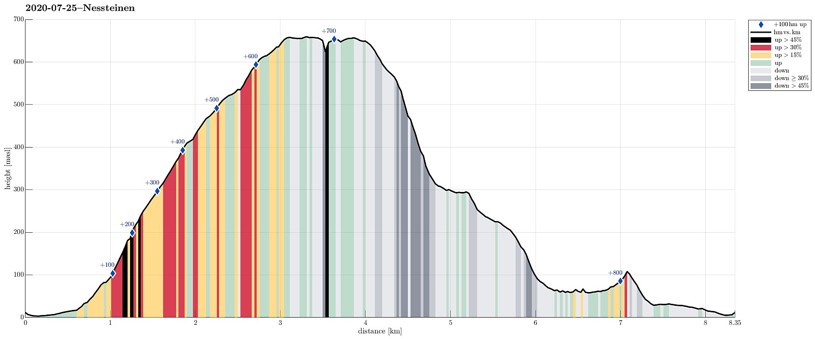
| Vertical meters | 834m |
| GPS |
|
| Ascents | Nessteinen (663m) | 25.07.2020 |
|---|
Trip Summary
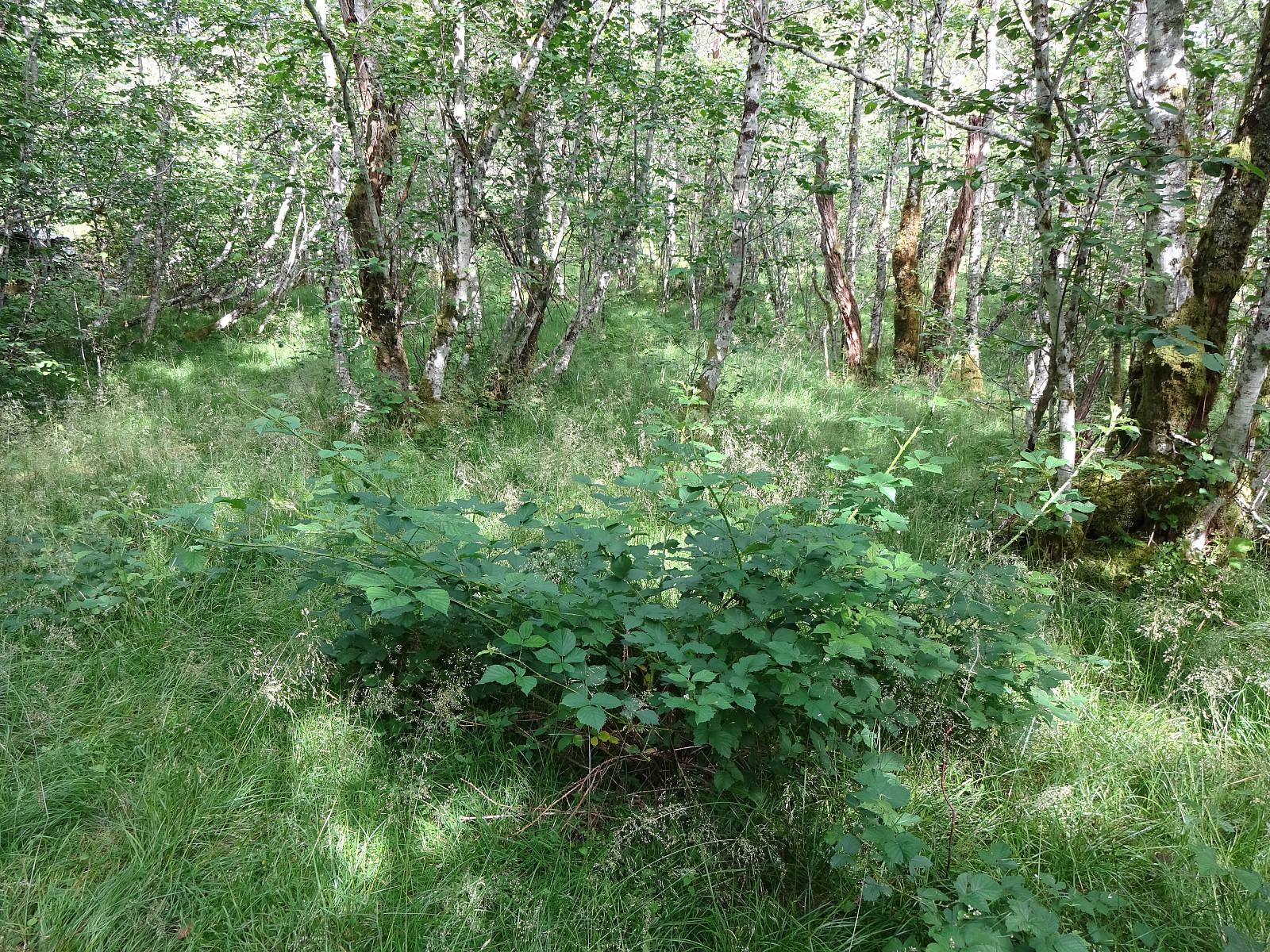
Having been "in the area", we decided to include a hike up to Nessteinen (or Steinen), expecting some nice views over Hardangerfjorden from up there. Another reason for choosing something not more extensive was the expectation of an overcast day with somewhat unstable weather. We drove the very nice road 49 from Norheimsund southwards (first around Visoldo to Strandebarm and then further southwards along Daurmålsegga to Mundheim). In Mundheim, we parked and started our hike first for a few meters northwards along road 48. At Oppheim, we crossed Storelva and walked up a simple field road to about 50mosl, where the field road meets the forest. From there, we continued along an not really used forest road, leading diagonally upwards (in eastern direction). At about 75mosl, however, the continuation became less obvious. We knew that we should surround the western cliffs of Steinen in their south, ascending at the same time to about 150mosl. Following a "diagonal approach" (both southeastwards, while also ascending), we made it to exactly this "point" (at 150mosl and south of the cliffs, just west of some stream(s), coming down "also diagonally, but from the northeast). From there, it's then relatively straight forward, again, following a minor ridge in the east of a stream that comes down "diagonally" from Steinen in its south. This ascent is really very nice, leading through some lovely, half open forest. Following this long "diagonal" up to about 525mosl, we came close to the up end of the forest, more or less exactly south of the top of Steinen. From there, we changed from "diagonal mode" into "straight up mode", finding some approrpiate spots to do so. At around 600mosl, this involved a bit of walking left and right in order to get over some crossing ridges. Soon after, however, we arrived at the top, enjoying some great views over Hardangerfjorden as well as northwards into the direction of Gjøna- and Tveitakvitingen. We then approached the northern cliff of Steinen, which drops dramatically down to Vatnadalsvatnet, some 200hm below the heights of Steinen. We then discussed whether or not to include also Vedasnerta. This idea comes with the substantial challenge of getting down from Steinen first (with basically all of its sides being steep to very steep). Having enough respect for the steep sides of Steinen, we chose to first follow a trail that connects the lower regions east of Steinen with its top. This (marked) trail leads steeply downwards, first in southern direction, then "back and forth" in southeastwards direction. At about 500mosl, we had a second thought about "cutting short" to the saddle to Vedasnerta, but did not follow this idea any further (mostly because of the very steep terrain, leaving a large portion of uncertainty regarding the complete connection to the saddle). Instead, we followed the trail down to about 300mosl, where the terrain flattens out substantially. There, we could have engaged with another ascent to Vedasnerta, or followed the the marked trail further (probably to meet a forest road a little further down). Instead of all this, we started to follow some nice forest trails in southern direction, walking smoothly through some very nice forest, descending only very slowly to about 290mosl, where the terrain again became a bit more steep. Still, walking along these forest trails continued to be very nice and pleasant. At about 225mosl, we crossed another small saddle, just to continue further down right next to a little stream. At about 150mosl, we were pretty close to the forest road, again, but did not see it (and did not have any plans of changing over it). At about 110mosl, we made a decision to try avoiding the road altogether and started a traverse parallel to the road at about 75mosl. We made it about half way to Mundheim, this way, getting into steeper and steeper terrain. Eventually, we "got trapped" between some significant cliffs on our right and the power line on our left. The power line proved to be a significant obstacle, since instead of trees some very thick low vegetation, including a lot of blackberries that REALLY shy one away from "breaking through with force". Thus, we decided to return back to the point, where we had left the trail. From there, however, it was then easy and fast to get down to the street. Eventually, we just made this short walk back along the road, concluding this interesting hike. All in all, it's remarkable, how steep basically all the sides of Steinen are, making such a "round hike" a bit of an adventure! :-)
Photos
Selected photos are available as Google photo album.
Useful Resources
See also the related FB-page Hiking around Bergen, Norway.
Petter Bjørstad has a useful page about Steinen and also web page WestCoastPeaks.com provides useful information about Nessteinen.
Web page UT.no from the Norwegian Trekking Association recommends another hike up Steinen.

User comments